Keweenaw Rift
 

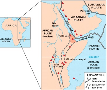
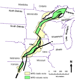
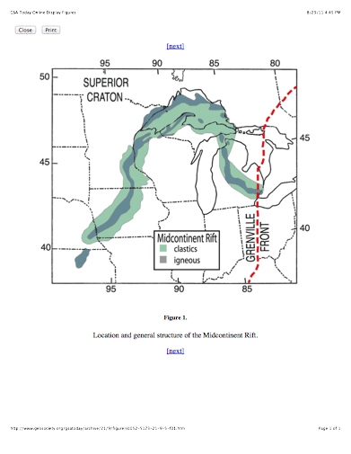
The Lavas of the Portage Lake Lava Series are the result of a continental Rift, very much like the currently active Red Sea. Existence of a rift is a way to explain how such huge volumes of lava could have been erupted. It also helps explain the syncline we already proposed. A great crack across North America formed, stretching from Kansas to the UP and then on to Detroit.

A one hour lecture about this rift can be viewed with one click!

The USGS map at left shows the East African rift zone and the Red Sea.  These are areas where rifting is occurring now.  In these places there are many black basaltic lava flows accumulating within rift basins, and there are also broad alluvial fans filling the basins from the steep flanks.


Rift Formation Links

               The East African Rift

               Keweenaw Virtual Field Trip

               Iowa’s almost ocean

               The Grenville Orogeny

               The Proterozoic

                   The Mid-continent Rift

The map at right from the Iowa Geological Survey shows the western limb of a feature called the “mid-continent gravity high” a linear feature that extends from Kansas to Lake Superior where it coincides with the Lake Superior Syncline.  This feature is mostly completely invisible, but was detected by geophysicists working with gravity meters, who showed that the gravity attraction of earth to the instrument is measurably higher, indicating dense rock underneath. The map shown here has that buried dense rock region colored green. The dense rock could be the dense black lava flows we have in the Keweenaw, and their gravity shows that the rift was hundreds of miles long.  Drill holes have penetrated the lavas in Kansas and Iowa, so we know that lavas are there--it is not just gravity detection.

A second geophysical anomaly, this one even more deeply buried, has been discovered extending from Lake Superior southward to near Toledo Ohio.  This adds to the definition of the hypothesized Keweenaw rift, which is sometimes described as a continental scale fissure, which resembles what happened in the Atlantic to separate Europe from North America.

The eruption of lavas in large volume is associated with “hot Spots” which are found all over earth now (eg Hawaii, Iceland).  Hot spots are coming from the core and mantle of the earth which are very hot. We don’t know enough about them to predict when they happen, but we do map them and keep track of their activity.  When hot spots start they can produce huge volumes of lava, like the black areas on the map.  The Keweenaw was one of these back areas--not shown in this map which covers young geological periods.

Stein et al, 2011 GSA Today