This page is a user guide to analysize TOMS data for monitoring sulphur-dioxide and aerosol emitted by large volcanic eruption. The analysis is done by using a software package TOMSPLOT to do all the image processing and data analysis and computational work. The retrival methods of aerosol and SO2 are only used when a volcanic cloud can be detected. For the below guiding, headings are blue, instructions (buttons) are red, and typed instructions are orange, links are purple and underlined

Part one - Starting the TOMSPLOT software package

The TOMSPLOT software package is writing in IDL. By opening an Xterm, you can type in tomsplot3b, the idl and TOMSPLOT will start automatically, and a window titled "Tomsplot:Image Display" will be poped up.

Part two - Loading in the data needed

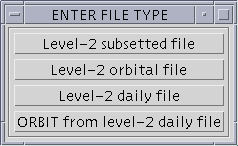
Together with the image display window above, a window titled "ENTER FILE TYPE" will also be poped up.

After clicking the type of data you will use (e.g. Level 2 Daily File), a window titled "Select N7 Level-2 Daily Data File" will be poped up.

After clicking the year and the proper subdirectory, you can select an orbit or daily file as below to load in the data.

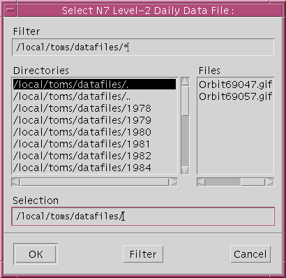
After clicking "OK" button, a window titled "MORE DATA" as below will be poped up.

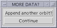
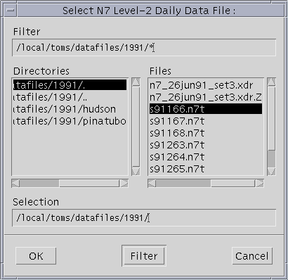
If you click "Another One" button, it will go back to the window titled "Select N7 Level-2 Daily Data File". If you click "Continue" button, then a new window titled "MAIN MENU" as below will be poped up.

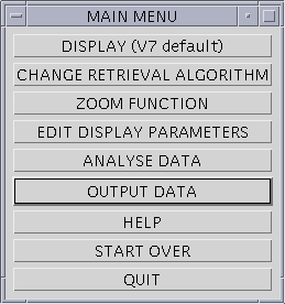
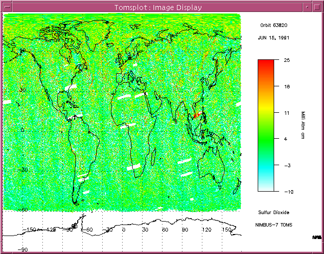
After you click the "DISPLAY (V7 default)" button, the window button will be somewhat like below.

Part Three - ZOOM FUNCTION

By clicking the "ZOOM FUNCTION" Button on the "MAIN MENU" window, a new window titled "Zoom function" will be poped up as below.

After clicking "Mouse ROI define" button, you can click on the image for the lower-left point of the area of interest (AOI) for your "zoom in" image after you view the small window filled with "please click the lower-left point of AOI" (the window will be disappeared very quickly, please pay attention to it). Then you can click on the image for the upper-right point of the area of interest (AOI) for your "zoom in" image after you view the small window filled with "please click the upper-right point of AOI" (the window will be disappeared very quickly, please pay attention to it). After these, the "MAIN MENU" window will be returned. By clicking the "DISPLAY (V7 default)" button on the "MAIN MENU", the AOI image will be displayed as below in the "Tomsplot: Image Display" window.

If you click "ZOOM FUNCTION" button again on the "MAIN MENU", and then click "Zoom out to max" button on the "Zoom function" window, you can get the original big image again in the "Tomsplot:Image Display" window.

Part Four - CHANGE RETRIEVAL ALGORITHM

By clicking the "CHANGE RETRIEVAL ALGORITHM" button on the "MAIN MENU" window, you can get the following information on the original "xterm" window: "Which algorithm (where 312 is 1, 317 is 2, 331 is 3, 340 is 4, 360 is 5, and 380 is 6): (so, eg, 1234 uses the 312, 317, 331, and 340 nm channels) :", usually we select 1234 for nimbus-7 data, then you can get the following information on the screen:
" jno_index = 13313
sat= 1
pts= 13313
alg= 1234
For old (Version 6) SO2 (Geom.path) input 6

For new SO2 (RT path) input any other integer:", here we usually select 6 for getting the results from algorithm 6 and 6a, which we think is more accurate for volcanic cloud SO2 study.

Note: Here SO2 values (as well as ozone) in all the pixels of image (daily or orbit image) will be recalculated no matter if the image in the Display window has been zoomed in or out. If you only want a part of image be recalculated with algorithm 6 & 6a, you need first to click "Analysis Data" button in the mean menu to select area of interest (AOI) with the new poping up window (reference to part five - Analysis Data section), and this will save much of time for data retrieval.

Part Five - ANALYSE DATA

By clicking the "ANALYSE DATA" button in the "MAIN MENU" window, a new window titled "ANALYSIS MENU" will be poped up as below:

If the "Keyboard ROI define" button is clicked , the keyboard can be used to select "region of interest" by typing in the latitude and longitude values of bottom-left and upper-right points of ROI. If the "Mouse ROI define" button is clicked, the mouse button can be used to select ROI by clicking the bottom-left and upper-right points of ROI on the image. After either of the above steps, by clicking the "Return to MAIN MENU" button and clicking the "Display" button in "MAIN MENU", an iamge only with ROI will be displayed in the "Tomsplot: Image Display" window as below:

The above procedure can be redone as many times as you want to get the exact ROI you want. If the "Iterative analysis" button is clicked, a new display window titled "Tomsplot: Data Analysis" will be poped up with "N value vs Wavelength" plot displayed as below:

If the "Tonnage calculation" button on the "ANALYSIS MENU" is clicked, the total tonnage of SO2 in the whole ROI will be calculated. This is the original procedure to do the tonnage calculation, the scan_area from satellite orbit scanning position instead of pixel area calculated in the code is used, and the minimum values of latitude and longitude of ROI are got from min(within_region) instead of directly from clicking point (this might cause problems some time). If the "Tonnage calculation (modified)" button on the "ANALYSIS MENU" is clicked, the total tonnage of SO2 in the whole ROI will also be calculated. The difference is that calculated pixel area is used instead of scan_area, and also the minimum and maximum latitude and longitude values of ROI are got from clicking points directly instead of min(within_region) and max(within_region). If the "Tonnage calculation (even area)" button on the "ANALYSIS MENU" is clicked, the total tonnage of SO2 in the whole ROI will also be calculated, but the ROI is divided into evenly area of pixels, the number of pixel is the same as before, the old pixel SO2 values, which is decided by the four corner values of old pixel, are used for the new pixels. If the "Tonnage calculation (smaller grid box & near nei.)" button on the "ANALYSIS MENU" is clicked, the total tonnage of SO2 in the whole ROI will also be calculated, but the box grid point value is decreased from 0.5 to 0.1, therefore, the number of pixel within ROI is increased to 25 times of original. The ROI is evenly divided, and the SO2 values of the new pixel are got from that of old pixels through nearest neighbor method. If the "Two variable retrieval/spreadsheet method output" button on the "ANALYSIS MENU" is clicked, the retrieval method can be selected as in part four, and the total SO2 tonnage is calculated using the spreadsheet method (Dr. Gregg Bluth has a note on the description of spreadsheet method, which might not be accurate enough but useful for comparsion purpose). The output will be printed on the screen. If the "Data limits and V7 stats" button on the "ANALYSIS MENU" is clicked, the below message will be appeared in the original xterm window, which should be quite easy to figure out the means:
Region of Interest :
Latitude min,max : -59.9800 89.6400
Longitude min,max : -179.270 176.600
V7 SOI min,max,av,sd : -41 43 2.14202 6.10098
Ozone min,max,av : 233.800 448.900 308.778
Reflectivity mn,mx,av : -6.32000 101.390 35.3489
SZA min,max,av : 10.2400 84.6000 47.5550
GMT min,max : 04:18:22 05:08:56
Path min,max,avg : 2.0824203 11.633355 3.3377520
Scan Posn mn,mx,av : 1 35 17.6215

If the "Show data values" button on the "ANALYSIS MENU" is clicked, the below message will be printed on the original xterm window, and you can select to save it as an ASCII text file or not.
FILE NAME : /local/toms/datafiles/Orbit 69049
DATE : JUN 27 1992 POINTS : 4
Minimum Maximum Average St-Dev
Latitude (degrees) : 67.2400 67.7900
Longitude (degrees) : 76.7200 78.7700
V7 SOI (DU) : -1 12 7.25000 5.73731
Lat Lon Ozone V7 SOI Refl AER SZA Scan Error Time
(deg) (deg) (DU) (DU) (%) (#) (deg) Posn Flag (GMT)
67.35 78.77 379.3 12 75.49 -0.30 47.28 7 0 04:56:56
67.24 77.02 369.8 -1 80.36 -0.60 47.60 8 0 04:56:56
67.79 78.52 377.1 8 82.48 -0.20 47.70 7 0 04:57:04
67.68 76.72 372.2 10 77.49 -0.30 48.01 8 0 04:57:04
Do you wish to save this table to an ASCII text file? (y/n):

Part Six - EDIT DISPLAY PARAMETERS

If the "EDIT DISPLAY PARAMETERS" button in the "MAIN MENU" window is clicked, the "Display Parameters" window will be poped up as below:

It is pretty straight forward for most of function buttons on the "Display Parameters" window. If "Change Variable" button is clicked, the below menu will be appeared in the previous xterm window as below:
(O)zone
(S)ulfur Dioxide
(R)eflectivity
(A)erosol Index
(C)ombination (V7 SOI & reflectivity)
(Z) = combination + oZone contours
(1) 312.5 nm N-Value
(2) 317.5 nm N-Value
(3) 331.2 nm N-Value
(4) 339.8 nm N-Value
(5) 360.0 nm N-Value
(6) 380.0 nm N-Value

Enter option :
Then you can select one of the above variable as the displayed variable in the display window by typing in the letter in the bracket. For Ozone and Sulfur Dioxide, you will be furture asked "(O)perational or (T)wo variable retrieval", they are correspondent to v7 and v6(v6a) retrieval results, if "(T)wo variable retrieval is selected, v6(V6a) results need have been produced by clicking "Two Variable Retrieval" button in "Analysis Data" menu (Please refer to Part V: ANALYSIZE DATA above). If "Change Projection" button is selected, the following options will be appeared in the original xterm window:
Enter projection :

(A)utomatic plot (limits & scale will be set)
(O)rthographic plot
(S)outh Polar Stereographic plot
(N)orth Polar Stereographic plot
s(T)ereographic plot
(SAT) geosynchronous satellite projection plot
a(Z)imuthal equidistant plot
(M)ercator plot
mo(L)lweide plot
(H)ammer-Aitoff plot
s(I)nusoidal plot
(C)ylindrical equidistant plot

Option letter :

The corresponding plot can be selected by typing in the letter in the different brachet. If "Change plot method" button is clicked, "(F)ootprint plot" or (N)umber plot" can be selected by typing in "F" or "N", respectly. If "Chang Scale" button is clicked, you can change the minimum and maximum scale in the display window by typing in the minimum and maximum scales in the original xterm window. If "Change Color Table" button is clicked, a "Select Color Table to Load" window will be poped up as below for you to select the color table you want.

"Chang Title" and "Change Font" button need to be clicked if the title or the font want to be changed in the display window. "Label Volcano" button need to be clicked if you want the location of volcano be labeled on the display image, and "Add/delete labels" button can be used to add or delete the labels. If the "Image per page" button is clicked, 1/2/4 images per page can be selected by tying in 1, 2, or 4. If "Resize Window" button is clicked, the below message will be appeared on the screen for you to change the display of the image.
Current display window size : 640 480

Choose from (1) 640 x 480 (workstation)
(2) 400 x 300 (macintosh or PC)
(3) 512 x 384 (video) 1

If "Change plot color bar" button is clicked, the plot color bar can be changed. If "Add boxes" button is clicked, by typing in coordinates of min & max latitudes and longitudes, a box can be added in the image. If "USA states" button is clicked, the states can be added in the image. If "Use CIA Data" button is clicked, the following message will be appeared on the screen for you to select resolution:
Enter 0 to NOT use CIA data
Enter 1 to use low resolution CIA data (fast)
Enter 2 to use medium resolution CIA data (slow)
Enter 3 to use high resolution CIA data (very slow)
Enter option :
If "Lat/Lon" grid button is clicked, the grid lines of latitude and longitude can be added. If "Edit Color Table" button is clicked, the color table can be edited. If "Help" button is clicked, the help message can be get from the original xterm window. If "Return to main menu" button is clicked, you can return to the main menu.

Part Seven - OUTPUT DATA

If "OUTPUT DATA" button in the "main menu" widget is clicked, in the pull-down menu, you can select "postscript" for postscript format output image to be saved, or "GIF" for gif format output image to be saved, or "text" for text format data output to be saved, or "print" to print out the image from the default printer.

In the "MAIN MENU" widget, if the "RESTART" button is clicked, the tomsplot software package will be restarted. If "LOAD RELATED DATA" button is clicked, another data set can be loaded in simultaneously. If "HELP" button is clicked, the help message will be appeared in the original xterm window. If "QUIT" button is clicked, tomsplot software package will be closed formally.