Getting There
So, to get to Magadi ...
There are some interesting places on the road to Magadi, and these places are presented here. However, there are some things you should watch out for on the way- like matatus. They drive like maniacs, are often brightly colored, creatively painted, and almost always stuffed full of people. I actually recommend hiring a driver as they will know how to manage the traffic in Nairobi...I certainly would not be brave enough to drive here..
The rural roads out to Magadi are pretty narrow- at least by US standards.. I’d say the entire road is about 1.5 normal US lanes, and there are only painted lines around corners and on some hills. Most people will drive in the center of the lane until opposing traffic appears. Often it can be quite close when passing a large vehicle/truck. Speed bumps are the primary form of speed control, and they are fairly serious bumps that require a significant reduction in speed. Fortunately they are often painted so you can see them in advance.
You should try to get a car with a little guts, as some of the hills are fairly long and some cars seem to lack the power to handle them efficiently..
Watch out for Maasai, and their assorted cattle, goats, donkeys, camels and dogs. You will also have to occasionally break for baboon families, tortoises, birds, and other such wildlife.
As a final note: it is often quite HOT in Magadi- you drop down ~1060m going from Nairobi to Magadi. Bring water, and for you fair types, sunscreen, hats and sunglasses are all good ideas. I’d also recommend full pants rather than shorts, especially if you want to walk around and look at rocks- some of the local plants have nasty thorns.


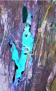
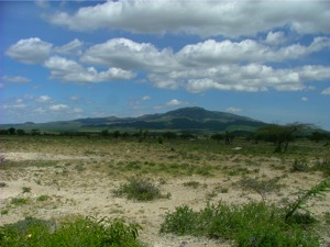
You’ll see a sign for the prehistoric site and a dirt road on the left (South). If you look to the South you’ll see Olorgesailie, an extinct volcano. Notice how flat the land is around you- this used to be a lake ~1 my ago! The volcano is about 1760m high.


1° 33.906 S

36° 26.687 E


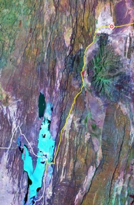
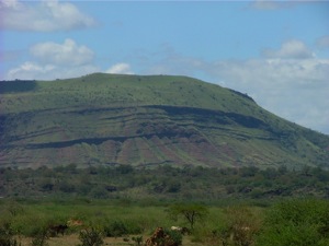
An older map I have (B.H. Baker, 1958) calls this old volcano ‘Ol Doinyo Nyegi’- Anyway, these horizontal ridges seen in the side of the volcano are obsidian flows. This mountain is ~1170m high, and is cut by several faults. The map shows where on he road this picture was taken, and the arrow is pointing to the actual volcano.


1° 48.748 S

36° 19.741 E


UTM: -9826835.61

215678.95

UTM: -9804065.43

204665.73