
Great Lakes Ice Home |
Outreach Page | Great Lakes Remote Sensing | Remote Sensing Institute |
AVHRR Thermal and Albedo Response of Mid-Lake Ice, March 12, 1997

Lake Superior albedo March 12, 1997 AVHRR band 2 (visible)
There are three mid-lake ice regions present in channel two of the AVHRR imagery. The grease ice mass (1) has notably lower albedo (2.19 to 3.04%) than the consolidated pack ice (4.0 to 6.0%). Leads are present within the grease ice mass with similar albedo (0.49 to 0.92%) as the open water in the East Basin (0.46%). The northern portion of the consolidated ice pack is distinguishable from the rest of the consolidated pack by its lower albedo (2.61 to 3.46%). This could be due to absence of snow cover, presence of fractures and leads, or flooding.
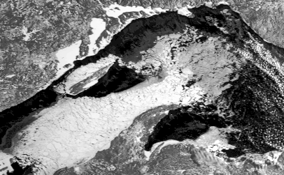
312avhrr2histeq.gif (albedo)
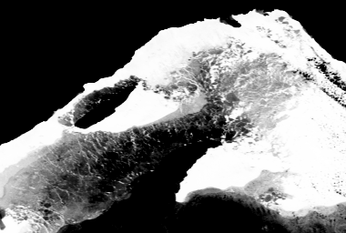
Lake Superior surface temperature March 12, 1997 AVHRR band 4 (thermal infrared)
Distinct TB in the AVHRR correspond to different ice types and ages consistent with differences in backscatter signature. Four mid-lake ice regions are evident, separated by distinct tonal boundaries. Three of these four regions (1, 2, and 3) are within the consolidated pack ice, the fourth region is the grease ice mass (4). The northern region (1) of the consolidated pack ice bordering open water is warmer than the rest of the consolidated pack ice and has relatively bright tone. Region 3 is colder than the rest of the consolidated pack ice and has relatively dark tone. An extensive network of leads in the grease ice mass have bright tone, inferring the presence of open water. No open leads or fractures can be seen in the consolidated pack ice. The SAR defined tonal boundary within the grease ice mass is not present in the thermal band.
The three brightness temperature regions within the consolidated pack ice are interpreted to be distinguished by changes in ice thickness. The ice in region 1, the warmest of the three (thinnest ice), is the same ice as the dark toned consolidated pack ice which accreted after the establishment of the consolidated brash strip in the March 11 SAR image. The position of the consolidated brash strip indicated that this ice is younger than the rest of the consolidated pack ice. This is consistent with its warm brightness temperature. Ice thickens through time, and younger ice is expected to be thinner than older ice (Barnes, 1906). The boundary between regions 2 and 3 coincides with the lateral fault found in the March 11 SAR image. Ice thickness variation is not necessarily expected across a lateral fault. The ice in region 3 is thicker than the ice in region 2. This is perhaps due to the compression of region 3 against the Keweenaw Peninsula by wind action.
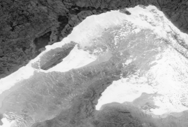
312avhrr4tera.gif
Lake Superior thermal infrared brightness temperature, March 12,
1997. In the brightness temperature image of Lake Superior, open
water (bright) has TB of 0 to 2 oC, land has
TB of -22 to -17 oC (dark), and most lake ice has
TB of -19 to -3 oC (intermediate). The ice in Thunder,
Black, and Nipigon Bays have TB of -31 to -26 oC, which
implies that it is thicker than other ice on the lake.
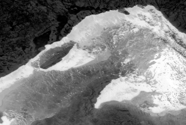
312avhrr4histeq.gif
AVHRR band 4 calibrated to brightness temperature.
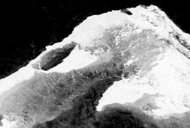
312avhrr4stretch90.gif
AVHRR band 4 calibrated to brightness temperature and linearly
stretched from -23oC (DN 90) to 15oC (DN 255) in order to emphasize
mid-lake ice brightness temperature regions.
312avhrr4stretch140.gif
AVHRR band 4 calibrated to brightness temperature and linearly
stretched from -10oC (DN 140) to 15oC (DN 255) to further emphasize
mid-lake ice brightness temperature regions.