Executive Summary
Introduction
The Eruption So Far
Volcanic Hazards on Montserrat
Gathering of Information for Volcanic Hazard Assessment
History of Soufriere Hills Volcano and Other caribbean Volcanoes
Monitoring
Empirical Data and Theoretical Models
Scenarios for Future Activity
Duration of the Eruption
Likely Scenarios
Bigger Events
After the Eruption
Hazard Assessment
Dome and Edifice Collapse Hazards
Tephra Fall Hazards
Fine Ash Hazard
Pyroclastic Surge Hazards
Lahar Hazards
Volcanic Landslide Hazards
Very Large Magnitude Explosive Events
Earthquake-Generated Volcanic Phenomena
Concluding Remarks
Appendix A: List of Attendees, Their Affiliations and Expertise
Appendix B: Terms of Reference
The terms of reference here are a summary of various correspondence between the British Geological Survey, DFID and the Foreign Office. The tasks are divided into two stages: a scientific assessment (stage 1) and a risk analysis (stage 2).
Appendix C: Glossary of Terms
Appendix D: Procedure for Probability Assignment
At the core of any quantitative risk assessment is the procedure for probability assignment. Montserrat happens to be the first volcanic crisis in which a formalised elicitation methodology for probability assignment has been applied. The reasons for this precedent are several. The methodology itself has developed to its present technical maturity and decision-making applicability over the past two decades, during which only a few volcanic crises have arisen. The prolonged duration of the Soufriere Hills Volcano crisis has allowed a sufficient window of opportunity for the elicitation methodology to be utilised, and the constructive and willing co-operation of Caribbean, British and American volcanologists has permitted its practical implementation. Not all political environs would necessarily be as conducive to such international co-operation.
It has been traditional for volcanological advice to civil authorities to be presented in essentially scientific terms, rather than expressed quantitatively in the language of risk which facilitates political decision-making. Compared with conventional volcanological deliberations, no less discussion, debate and peer-review have taken place in the current context, but a substantial volume of supplementary work has been carried out to translate volcanological judgement into risk terms.
The value of achieving a quantitative expression of risk lies in the possibility of evaluating explicitly the consequences of alternative decisions. Vague expressions such as 'unlikely event' and 'severe casualties' can be replaced by numerical estimates of event frequency and loss probability. In addition, because risk results can be traced back to original premises through an arithmetically defined event tree, the chain of reasoning is much more transparent and explicit than in a purely qualitative argument.
Quantification of risk demands a numerical representation of uncertainty. For a complex natural phenomenon such as a volcano, which is partly subterranean and beyond direct observation, uncertainty takes several forms. There is epistemic uncertainty arising from lack of knowledge of the internal geometry and dynamical characteristics of the volcano. There is aleatory uncertainty associated with inherent random variability in the dynamic evolution of a multi-state stochastic system.
The state-of-the-art in volcanology has not yet reached the stage where detailed dynamical models can be constructed to simulate many eruptive processes reliably. Therefore, the task of assessing the likelihood of alternative future event scenarios has depended on the elicitation of expert judgement of volcanologists experienced not only with the Soufriere Hills volcano, but with worldwide knowledge of volcanic eruptions. The use of expert judgement is standard practice in quantitative risk assessment pertaining to geological issues, ranging from earthquake and landslide exposure to groundwater pollution. Observational results are rarely so abundant that a substantial measure of data inference is avoidable, and the manner in which earth scientists draw these inferences is open to a certain degree of subjectivity.
The elicitation of expert judgement has been conducted with care to maximise the advantages gained from the pooling of data, the sharing of ideas and interactive discussion, whilst respecting the diversity of views and strong convictions held by individuals. Thus a meeting of principal volcanologists was convened in early December so that all volcanological issues could be addressed within the framework of a decision conference, at which an open interchange of knowledge and opinion could be encouraged and facilitated during extended periods of discussion.
But rather than narrow the outcome of any discussion topic to a consensus view, attention was paid to eliciting individual responses. These responses have then been analysed using specialist software developed for eliciting a full spectrum of expert judgements. The algorithms underlying the software are rooted in the formal mathematical theory of scoring rules.
In the formal elicitation of expert opinion, each participant is calibrated by a series of questions to ascertain his level of expertise and confidence with which he makes judgements. The calibration allows an expert's opinion to be weighted against the opinion of other experts, and the mean result of an elicitation is weighted in favour of those who demonstrate the greatest depth of knowledge and those who provide accurate opinions or assessments. As part of the calibration, experts are asked to give a range of answers or predictions to a series of questions to indicate their level of proficiency. Those who display less informativeness by providing a wider range of answers are weighted lower than those who give narrower and more accurate answers. In a full elicitation the scientific factors behind an issue are first debated before answering a question (e.g. how much longer will the Soufriere Hills eruption continue?). This prior debate ensures that all participants are as well-informed about the topic as possible. A suitable piece of information for the example question is that the global mean length of 167 historic dome eruptions like Montserrat is 5 years and that dome eruptions in other Caribbean volcanoes have lasted between 2 and 4 years. Another piece of information is that the Soufriere Hills has had 5 major prehistoric dome eruptions of about 0.5 km3 volume each. At the present rate of eruption it will take another 3 years to erupt comparable volumes.
There can be more than one elicitation cycle so that, if widely divergent views become evident from the answers, then the issue can be further debated and the elicitation revised. The debate for example might reveal that the question was misunderstood by some participants or one line of argument or evidence was not properly comprehended. This further debate might lead to consensus being achieved or to a hardening of opinions, which would be recognised in the probability assignments.
At the meeting, the formal elicitation of opinion proved to be a very useful exercise and has provided an effective mechanism for focussing debate and classifying opinions on key questions relating to the volcano. An important virtue of elicitation exercises is the effect it has of concentrating minds on new aspects of risk. Moreover, the working group of scientists were able to combine the method with some of the more traditional approaches. Having identified key issues, sub-groups were delegated to discuss particular topics and to bring their findings to the main group for discussion.
The tasks were divided on the basis of specialist expertise within the group (for example a seismologist was asked to consider the occurrence of large magnitude earthquakes in the Caribbean and their possible effects on the volcano during the eruption were they to happen). The deliberations of a sub-group were then debated by others (a form of peer-review). Elicitations require for their credibility that questions are very well understood by all respondents; a requirement which is not always so easy to achieve. Iterations of the elicitation procedure were undertaken to resolve difficulties of this kind, where time allowed, or else there was resort to more traditional approaches of open discussion.
The efforts required to ensure comprehension of all questions underscores the need for the careful structuring of an elicitation procedure. As a general principle, in so far as resources permitted, elicited variables were decomposed into primary components which might more readily be estimated. Furthermore, where numerical models were available for gauging the effects of a particular hazard, e.g. tephra fall or pyroclastic flow, they have been used in assessment. Judgement are then restricted to estimating input parameter uncertainty in the models.
The greatest difficulty for the scientific assessment comes with the estimate of probabilities of the more extreme high impact events. There is often very limited empirical data or scientific basis for estimating the probability of an extreme event and this is best illustrated by reference to a particular example: the probability of an eruption 100 times more intense and 250 times the magnitude of the largest explosive eruption so far. An eruption of this scale has not taken place on Montserrat and there have been very few eruptions which have reached or exceeded this size in the entire Caribbean over the last 30,000 years. These eruptions have only occurred on the two largest volcanoes (Dominica and St Lucia) which have extensive records of large explosive eruptions. There are also global statistical figures for eruptions of this scale (1 eruption every 25 years for about 1500 volcanoes). There is also some information on how the probability of an eruption changes with increasing intensity and magnitude. However, many in the scientific group were of the opinion that the Soufriere Hills volcano is a relatively small volcanic system with magma freely flowing to the surface and with petrological features atypical of the magma bodies that produce large plinian eruptions and typical of volcanoes which produce dome eruptions. Thus the elicitation results reflect not only constraints from global or regional data, but the opinion that it is hard to see the volcano may not be capable of having such an enormous eruption.
Respondents' answers stopped short of saying that the eruption was impossible, as the first really big eruption of any volcano will have no previous record of such large eruptions and because all the working group recognise limitations in understanding. Because singular events are a key concern of the risk assessment, the practical limits of standard frequency-based classical statistics are apparent. From an observational stand-point, silence might be maintained on the long-term frequency of events not yet recorded. However, within the current decision-making context, the framework of modern probability provides an appropriate logical basis for representing volcanological expert judgement on the degree of implausibility of extreme events.
Appendix E: Scientific Resources
It is incumbent on the scientific team at MVO to provide some basic documentation of the scientific methods and information used to make the assessment. This is done here by reference to the scientific data available at MVO and by a brief and more technical description of key scientific issues and information used in the hazards assessment.
E.1 Data and analysis at MVO
A large amount of scientific data on the volcano has accumulated through the monitoring programme. The MVO produce a weekly scientific report summarising the main observations. There have been a number of special scientific reports on particular topics such as the 17 September 1996 explosive eruption, the seismicity, the dome volume calculations and the hazards relating to pyroclastic flows. These reports are available to members of the scientific community on request. The large amount of data gathered by a modern observatory means that the detailed analysis and research work lags behind the basic data collection and immediate interpretation for assessing the status of the volcano. Thus there are few publications. Two preliminary articles summarising the scientific work have appeared in Science (Vol. 276, pp. 371-372, 1997) and the Transactions of the American Geophysical Union (Vol. 78, pp. 404, 408-409, 1997). About 26 scientific papers, largely from the work of the MVO, were submitted to a scientific journal (Geophysical Research Letters) in September 1997 for a special issue on the eruption. These papers are currently under peer-review and have been circulating freely within the scientific community.
E.2 Interpretation of the eruption dynamics
The detailed documentation of this eruption resulting from the monitoring programme and allied research work are leading to constraints and new ideas on how andesite lava dome eruptions work. The interpretations may have considerable significance for hazards evaluations, but need to be very carefully applied. Many of the ideas emerging from Montserrat are scientifically exciting, but should be seen as working hypotheses, not well established facts. Many have not yet been through the full rigour of peer review and the scientific team is well aware of the pitfalls of placing too much weight on the latest exciting idea in a hazards assessment on a dynamical system as complex as a volcano. This section draws attention to some of the issues relating to the interpretation of the eruption and draws a distinction between well established information and areas of uncertainty relevant to the scientific assessment.
Many of the most important processes in a volcano occur too deep for direct observation. The source region is known as the magma chamber and the pathway to the earth's surface is known as the conduit. Volcanic theory attributes key controls to the properties of this source region and the conduit. The volume, pressure conditions, magma physical properties and dynamical processes in the magma chamber and the geometry and dimensions of the conduit are major factors in determining eruption processes. Were all these parameters well known, much more confident forecasts and interpretations could be made. Unfortunately many of the key properties are very poorly constrained.
The depth of the source is perhaps the best known parameter. It is estimated at about 5 to 6 km on the basis of phase equilibria and solubility laws for volcanic gases and is also consistent with geophysical data (earthquake depths and ground deformation results). Experimental studies and thermo-dynamical calculations demonstrate that the minerals in the lava can only be formed at pressures equivalent to these depths and the water dissolved in melt trapped within crystals demonstrates that the amount of gas dissolved is at these same pressures. There are few good constraints on the size of the chamber. Ground deformation in principle could be used to constrain magma chamber size, but in practice the deformations are dominated by shallow processes, masking the signature of the deep source.
The chamber must have excess pressures driving the flow to the surface, but there are few constraints. It must be greater than the pressure required to create a dome of height 250 m (about 4 MegaPascals (MPa)) and probably less than the strength of the crustal rocks at depth (about 20 MPa). The changes in driving pressure as the eruption has gone on are not known. There is good evidence that the magma has been reheated recently by hotter magma derived from much deeper in the earth. However we do not know for sure when this happened or indeed if it is still happening. If this hotter material is still invading the chamber to drive the eruption then the implications for the eruption dynamics, the potential for larger eruptions and the eruption duration are quite different than would have been the case had the invasion happened a few decades or centuries ago. We simply do not know.
Tied in with these considerations are the rheological properties of the magma in the chamber and the size of the conduit. If these parameters were well-known then it might be possible to state whether a much larger eruption is possible. The viscosity of the magma may be too high and the conduit too narrow to allow a large magnitude explosive eruption. In general volcanic theory indicates that this is a major reason why lava dome eruptions like the Soufriere Hills volcano often do not develop into large magnitude explosive eruptions. However occasionally dome eruptions do evolve into significant explosive eruptions years after dome formation initiates (see below). Experimental work is being carried out to better constrain the viscosity of the Soufriere Hills magma. However viscosity is very sensitive to magma properties such as temperature, gas content and crystal content and these may never be known sufficiently well to provide definitive answers. Conduit dimensions can be constrained from flow models and there are some observational constraints. At present these models imply a conduit cross-sectional area of the order of 1,000 to 1,500m2.
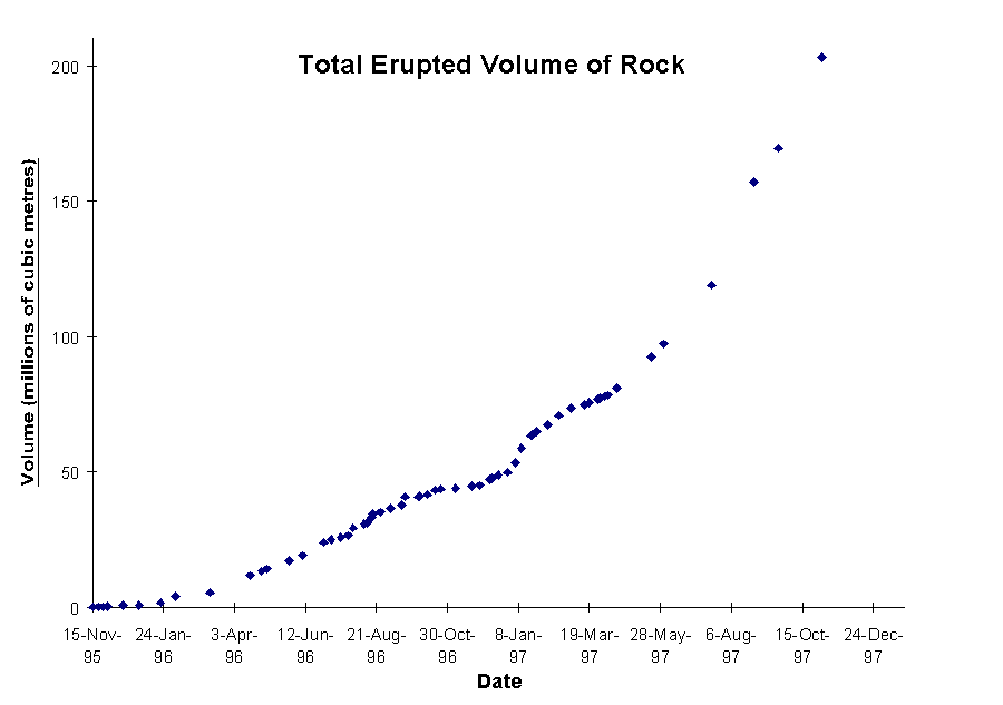
Uncertainties are as much as a factor of two however and it is still not clear whether this conduit is a cylindrical tube or a long narrow crack. The strong dependence of flow rate on the conduit width (to the third or fourth power) makes the uncertainties considerable. Furthermore the viscosity may vary by over nine orders of magnitude as it rises up the conduit, loses gas and solidifies. The flow laws for material with such very large pressure-dependent changes in rheological properties, including transitions from newtonian to highly non-newtonian behaviour, are themselves not well established. In this context for example the changes in flow rate in the eruption (Figure 2) can be explained either by driving pressure or viscosity or very small relative changes in conduit dimensions or more likely some combination of these three factors.
Considerable progress has been made in understanding the high level processes in the conduit and dome. The cyclic patterns of pressurisation that have been identified are believed to be related to the interactions between gas loss and the consequent changes of rheology of the magma. The indications are that many of the main variables being monitored are the consequence of shallow processes (within 2 km of the surface). While this progress is satisfying and exciting from a scientific perspective it has implications for the assessment. It is increasingly apparent that many of the signals and measurements relate to shallow processes and that the deeper processes are being masked or are difficult to detect.
In conclusion while scientific progress on understanding eruption dynamics has been considerable there remain a large number of unanswered questions and uncertainties.
E.3 Serious explosive events in dome-forming eruptions
A critical question on Montserrat is whether there is a possibility that much larger explosive eruptions can take place. The experts are all of the view that such eruptions cannot be excluded. Two kinds of phenomena need to be clearly distinguished: vertical eruptions and pyroclastic surges. From the point of view of hazards these two phenomena are easily distinguished but, in terms of the occurrences and circumstances of them happening, the scientific issues are a good deal more complex. The primary volcanic processes that can produce these two hazardous phenomena are such that they can occur independently (that is one occurs without the other) or they can occur together. In the case of pyroclastic surges in particular, understanding of the causes of the explosions is poor.
Sustained vertical explosive eruptions (known often as plinian eruptions) are relatively well understood. They require quite rapid flow of magma from the chamber into the conduit over the course of a few tens of minutes or hours. Plinian eruptions usually erupt predominantly low density pumice. The pumice on Montserrat is significantly denser (typically by 30 to 60%) than the pumice typically produced by plinian eruptions. World-wide, magmas that erupt in this way usually have low crystal contents, although examples with up to 35% crystals are known, compared to the 60 to 70% crystals in the Soufriere Hills magma. Thus the Soufriere Hills volcano is not typical of volcanoes where such eruptions occur.
As discussed in the main text, there is no evidence that a much larger explosive eruption has happened in the recent geological past (about the last 30,000 years). However, as discussed in E.2, we also cannot be sure that there are not suitable conditions in the volcano for this to happen this time. There are some examples of quite large magnitude eruptions happening several years after a dome has appeared. An example is Lascar volcano in Chile which had a substantial explosive eruption in 1993, 9 years after the andesite dome appeared. This eruption produced pyroclastic flows travelling to 10 km and a 25 km high eruption column, equivalent to an intensity over 10 times the reference event on Montserrat. This is a different volcano which may have different features which it make it possible to happen on Lascar, but not possible on Montserrat. However we cannot be sure. It is much more common for major explosive eruptions to happen in the first few days or weeks of an eruption and such late major explosive eruptions seem to be relatively uncommon. However they do happen.
Pyroclastic flows can occur in a number of circumstances. A minority of sustained explosive eruptions of the plinian type (perhaps 10 to 20%) produce large surges at the same time as the vertical column. Pyroclastic surges can be triggered by landslides as on Mount St Helens in 1980. They can also occur as high level explosions of great intensity lasting for a few minutes as at Mount Lamington in 1951. The surge of 1902 on Mont Pelee, Martinique is another example. In May of this year a large pyroclastic surge moving over 7 km occurred on Bezymianny volcano, Kamchatka Peninsula, 41 years after the andesite dome first started to grow. While these violent events are not common on dome eruptions, they do occur. Some pyroclastic surges are definitely triggered by large failures of a dome or volcanic edifice, but the circumstances that cause events like Mount Lamington are not understood. This lack of knowledge makes it particularly hard to estimate probabilities.
E.4 Modelling of hazards related to vertical explosive eruptions
The last 20 years has seen progress in the quantitative understanding of explosive eruptions and the tephra fall deposits. This work has recently been summarised in a book by Sparks and colleagues (Volcanic Plumes, John Wiley Press, pp. 557, 1997). The dispersal of tephra has been modelled from the fluid dynamics of volcanic plumes and their interactions with the wind field. These models predict distances that the range of rock fragments travel and have been validated by comparison with field observations. The modelling has also established a simple power-law relationship between the height of a volcanic eruption column and the intensity (mass flux) of an explosive eruption which is a major control on fragment range. Comparison of theoretical calculations with an extensive data set from historic eruptions yield similar power law coefficients from theory and from an empirical approach. The distance a fragment goes is also controlled by the wind and there is a reasonably good and validated understanding of wind effects. As a result it is possible to estimate the maximum range of fragments of interest (say 10 cm fragments of pumice) if the wind conditions and column height are known.
Estimates of thickness at a locality have to be based on a more empirical approach. Tephra fall deposits characteristically display exponential thinning away from the volcano and so can be characterised by a distance over which the thickness halves, known as the thickness half distance. There are systematic correlations between the thickness half distance and the height of the eruption column, reflecting the fact that in small eruptions most of the tephra falls close to the volcano and the deposits thin rapidly whereas in large eruptions the tephra falls over a much wider area. These relationships are supported by theory, but the theory is not sufficiently advanced to be comfortable with direct application, so that an empirical approach is preferred until the modelling work advances further. The thickness pattern is distorted by the wind with thinning occurring more rapidly normal to the wind direction and more slowly downwind. Again the degree of distortion can be established empirically and we have used unpublished data from a study of the tephra fall deposits of Mont Pelee, Martinique by G.P.L. Walker to constrain the distortion. These eruptions seem to have occurred under fairly standard Caribbean meteorological conditions. If the mass of erupted material (the eruption magnitude), the eruption intensity and the wind conditions are known then an estimate of thickness and the number of large clasts falling at a particular place can be estimated. These results can be then compared to criteria for roof collapse or injury in a risk analysis. Validation can be carried out by comparison of results with historic eruptions of comparable scale and conditions. There are of course uncertainties in such models but the parameters of interest are very strong functions of the main controlling conditions so that to first order the results stand up to scrutiny.
The hazards assessment uses the 17 September 1996 explosive eruption as a reference. From various observations column height was between 11.5 and 14 km for that eruption. Taking an average of 13 km gives an intensity of 7.5 x 10⁶ kg/s. The duration of the eruption is not well-constrained, but it lasted more than 10 minutes and the intensity decayed over about 40 minutes. A volume of 3 x 10⁶ m3 is estimated as the reference volume.
The meteorological conditions in the Caribbean provide some special conditions as the wind patterns are unusually complex with trade and anti-trade winds moving in opposite directions and seasonal reversals in direction. The high altitude wind speeds are weak compared to other parts of the world. In our models we have used data for Montserrat for the 1979 to 1995 period provided by the National Center of Environmental Prediction in Washington, USA. These data allow probabilities to be assigned to different wind directions and speeds based on the variance so that probabilities can be fed into the risk analysis. Winds are usually east and west and it is quite common for eruption columns to be split into two different directions. These complexities mean that there are some difficulties of comparison with tephra deposits from other parts of the world and that, where possible, other Caribbean examples should be used. Data from the 17 September 1996 eruption of the Soufriere Hills volcano and from Mont Pelee have helped in this respect.
A final problem is that eruptions can vary in both intensity and magnitude and each of these parameters has different influences on the level of hazard. This potentially makes a large number of permutations of conditions. However, empirically, the two parameters are not independent and a large global data set indicates a systematic increase in magnitude with intensity. Regression through this data set indicates that for every increase in intensity by a factor X the magnitude increases by a factor 2.5X.
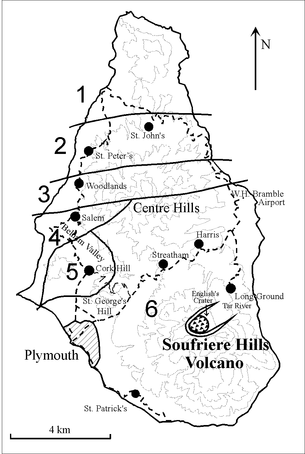
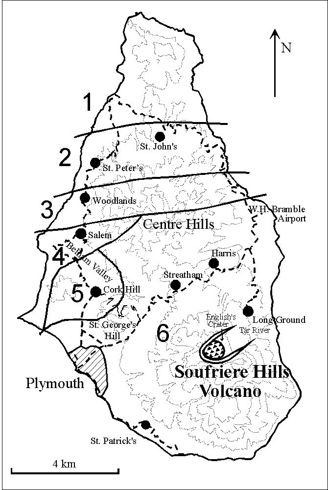
Figure 1: Key features of Montserrat and population zones (900x635 GIF, 6.5K -- 1225x865 GIF, 10K
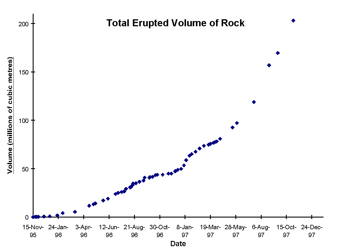
Figure 2: Volume of rock erupted from the Soufriere Hills volcano. (670x1000 GIF, 23K -- 980x1460 GIF, 38K