INTRODUCTION
Located in southwestern Guatemala, near the triple junction of the North American, Cocos and Caribbean plates, Santa María is the most notorious volcano in Central America. In October 1902 Santa María was the site of one of earth's 10 largest historic eruptions (Sapper, 1904). This eruption resulted in thousands of deaths and had global atmospheric impact. Since 1922 the explosion crater on Santa María's southwest side has been the site of volcanic dome extrusion at a vent called Santiaguito (Rose, 1972b). In 1929 pyroclastic flows, apparently resulting from the collapse of the active dome, flowed more than 10 kilometers to the south of Santiaguito, resulting in hundreds of deaths and damage to villages and plantations (Sapper and Termer, 1930). Santiaguito has remained active and is the site of vertical eruptions, avalanches, lava flows, pyroclastic flows, mudflows and other hazards, which are of concern to the rapidly growing populations that surround the volcano.
The purpose of this article is to inform the scientific community that Santa María-Santiaguito has been designated a Decade Volcano by the International Association of Volcanology and Chemistry of the Earth's Interior (IAVCEI) as part of the International Decade for Natural Disaster Reduction. We also aim to point out some of the many potential research topics that we hope will attract scientists from all over the world to work at this volcano.

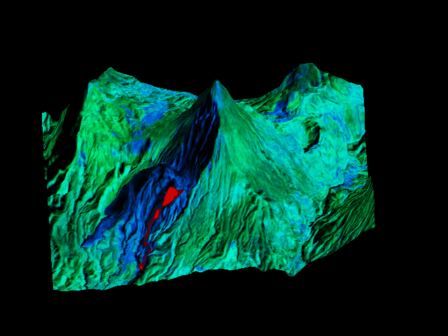
- False color composite of Thematic Mapper data showing band 6 in red, band 4 in green, and band 5 in blue for Santa María on October 25, 1987. The TM data is draped over digital elevation data for the same area, supplied by A. McEwen (USGS, Flagstaff. Because the thermal infrared data in band 6 reflects hot areas on the dome, the active lava flows at Santiaguito show up in red in this image. (Image processing by Rich Hossli, Michigan Technological University.)
(Bennett, Rose, and Conway, 1992)