The age of the edifice collapse is constrained by 5 radiocarbon ages from charcoal contained in the genetically-related pyroclastic blast and flow deposits. The radiocarbon ages range from 980 yr. B.P. to 1,440 yr. B.P. and cluster around 1,200 yr. B.P. (Conway et al., 1992). The 1,200 yr. B.P. age corrected for temporal variations in atmospheric CO2 is about 1,150 yr. B.P. (Stuiver and Pearson, 1986).
 Debris Avalanche
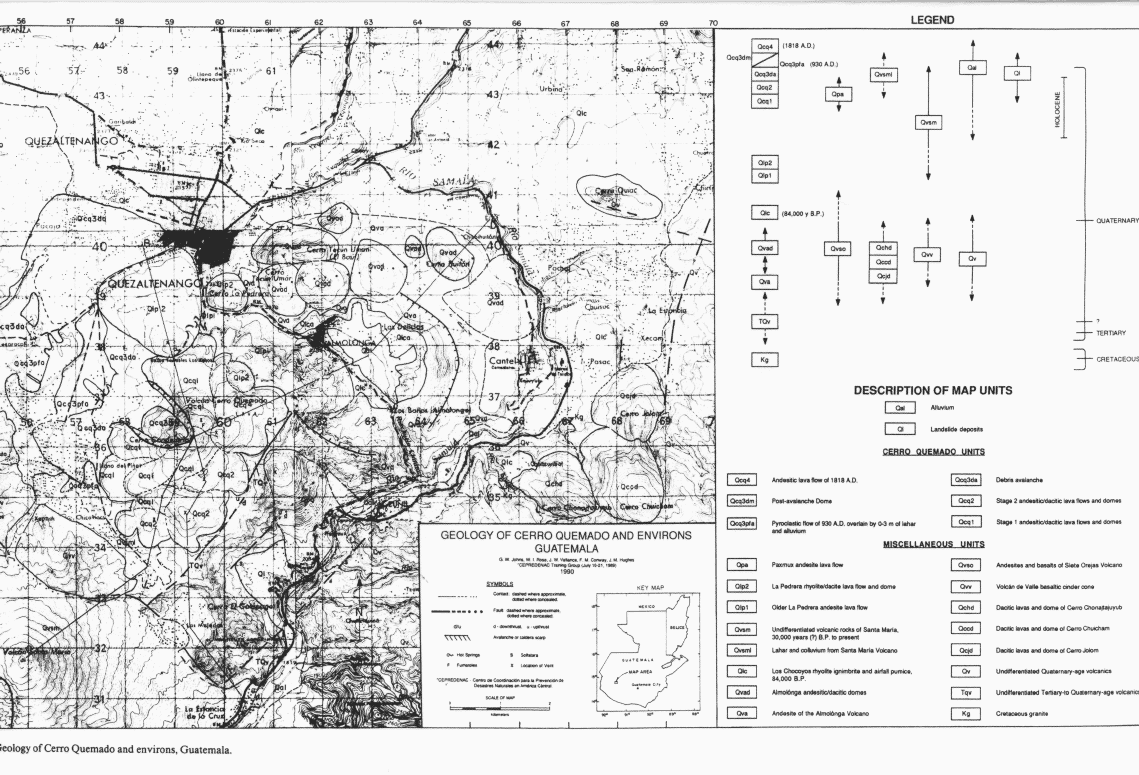
Quarrying of hummocks for road aggregate has exposed numerous cross-sections. Hummock deposits are unstratified, unsorted and massive, and comprised of subangular boulders up to 4 m in diamter in matrix of pebble-size clasts and sand. Both block and matrix include more than 95% Cerro Quemado rocks. Other inclusions are diatomite adn ripped up soil fragments. Diatomite clasts measure up to 1-2 m across and apparently were bulldozed from a dry lake bed on the floor of Llano del Pinal.
The volume of the avalanche deposit is 0.13 km³, identical to that enclosed by the scarp on Cerro Quemado (which averages 1.0 km wide, 1.5 km long, and 0.087 km deep). The distribution, composition, and morphology of the deposit are also consistent with collapse of Cerro Quemado. However, the relative timing and cause of dome collapse is uncertain. The avalanche caldera is located in stage 1 material but the fresh, uneroded appearance of the scarp zone and the absence of dense vegetation or tephra on the post-collapse dome (Qcq3dm) suggests a post stage 2 event. Moreover, the proximity of the avalanche caldera to the stage 4 event (Qcq4) indicates post stage 2 migration of the volcanism from the south to the central part of the dome complex. A possible mechanism for dome failure is shallow intrusion of magma and consequent dilation of the edifice causing oversteepening and ultimately failure of the west flank of the dome. This, however, suggests a somewhat greater role for endogenous growth at Cerro Quemado than is apparent from dome deposits.
(Conway et al., 1992)
Lateral BlastThe deposit is typically fines-deficient and contains carbonized twigs and stems and ripped-up soil. It is gray, unstratified and unsorted, and contains friable, fines deficient, openwork rock debris with angular and sub-angular blocks to 1 m in diameter. Vesicular blocks and lapilli and sparse breadcrust bombs suggests a juvenile component.(Vallance et al., in press)
These vesicular juvenile rocks and charred stems indicate that the fines-poor pyroclastic flow was hot, and its wide distribution and the absence of fine ash suggests it was energetic and highly inflated. All of this evidence suggests that the fines-poor deposit resulted from a lateral blast. (Conway et al., 1992)
The deposit is normally graded near its top, especially on hillsides further from its source. On hillsides about Llano del Pinal, the deposit generally becomes finer-grained away from the source, but nevertheless contains sparse coarser-grained bombs. In its distribution and texture, the blast deposit strongly resembles the deposit of the Sugar Bowl lateral blast at Mount St. Helens (Crandell and Hoblitt, 1986). (Vallance et al., in press)
In the valley and on opposing hillsides, the blast deposit is thin or absent on stoss sides of objects like hummocks or on ridges and thick (up to 2 m) on the lee sides of hummocks or in depressions. A thin veneer (<10 cm thick) mantles the east flank of Siete Orejas, to 3100 m. If the deposit has an average thickness of from 10 to 25 cm, than its approximate volume is 0.004 to 0.010 km³ (Conway et al., 1992).
Secondary Pyroclastic FlowsThe pyroclastic flow deposit forms a discontinuous sheet, extending from the south end of the valley to the lower north-central end, and is thickest where it abuts Siete Orejas. Thickness ranges from 22 cm to 6 m and is greatest in depressions. Llano del Pinal valley slopes northward but the pyroclastic flow is more widely distributed and thicker in the higher part of the valley. This distribution suggests a source other than the scarp zone on Cerro Quemado, because a pyroclastic flow from the scarp zone should have inundated the central Llano del Pinal and flowed north toward Quezaltenengo. We suggest that the fines-rich pyroclastic flow was derived from secondary flowage of the laterally directed blast deposit from surrounding hillslopes. (Conway et al., 1992)
A fines-rich pyroclastic flow deposit that overlies the lateral blast deposit in the Llano del Pinal valley has a distribution suggesting a source other than the scarp area. If the pyroclastic flow emanated from the crater, it should have inundated the central Llano del Pinal and then moved north toward Quezaltenango, but the deposits are principally found up valley to the south and also at the base of Siete Orejas. This distribution implies a different origin. We suggest that subsequent gravitational flow of the hot, lateral-blast debris from the surrounding steep hill slopes caused the fines-rich pyroclastic flow -- an origin similar to that of the valley-ponded pyroclastic flows associated with the 1980 lateral blast at Mount St. Helens (Hoblitt et al., 1981). (Vallance et al., in press)
Debris Flows
Deposits of small-volume debris flows crop out of the base of the avalanche scarp and in the Llano del Pinal valley near the base of the Siete Orejas. The deposits are typically unstratified, poorly-sorted mixtures of boulders and pebbles in a matrix of silt- to clay-sized particles. The deposits probably originated when loose debris from stage III eruptions moved downslope during torrential rains.
(Conway et al., 1992)
Associated Hazards
Hazards of debris avalanche
Hazards due to lateral blast, tephra fall, pyroclastic flow, and ash cloud surge
Monitoring volcanic hazards at Cerro Quemado