Directed Blast
In a typical volcanic eruption, an eruption column consisting of pyroclastic material is ejected into the atmosphere. The base of this column is known as the gas thrust zone where material is shot ballistically from the volcanic vent. Above this zone is the convective thrust zone. This zone is
where heat buoys pyroclastic material upward toward the top of the troposphere. Once the eruption column reaches the stratosphere, shearing occurs and the material is spread out in an umbrella shape (Francis, 1993).

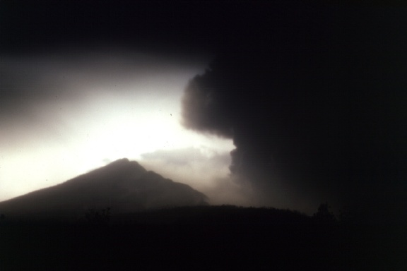
The May 18, 1980 eruption of Mount St. Helens did not initially produce such an eruption column. Instead, the initial eruption was a directed blast. This blast was a result of depressurization triggered by an earthquake initiated landslide on the north flank of the volcano. The area affected by the directed
blast extended greater than 19 miles from the volcano. Everything within eight miles of the directed blast area was either removed or destroyed. Topography in this area had no affect on the movement of material in the directed blast cloud. Between 8 and 19 miles of the volcano, trees were flattened and resembled toothpicks aligned in a uniform direction on surrounding hillsides.
 Material in the blast cloud was somewhat channelized within this zone. Greater than 19 miles from the volcano, trees were seared black due to hot gases (Tilling, 1987). Material from the initial blast cloud itself was very hot ranging between 100 and 300 degrees C
(Scott, 1989).
Material in the blast cloud was somewhat channelized within this zone. Greater than 19 miles from the volcano, trees were seared black due to hot gases (Tilling, 1987). Material from the initial blast cloud itself was very hot ranging between 100 and 300 degrees C
(Scott, 1989).
Several people were killed by the directed blast of Mount St. Helens. Mount St. Helens isn't the only volcano that has erupted with a direct blast. Its twin, Bezymianny in Kamchatka, Russia, also erupted in this way. Current research shows that direct blasts are not uncommon. The eruption of Mount St. Helens alerted scientists to the warning signs and hazards of such an eruption. Knowledge of direct blast eruptions will help in the future so
that warnings can be given to people in areas that might be affected by such a blast. Monitoring of volcanoes with seismographs and instruments that would indicate ground deformation can help identify hazardous zones and indicate areas of possible safety.
Text by C.M. Riley, MSH directed blast photo courtesy of W.I. Rose, Tree photo courtesy of the U.S. Geological Survey at CVO
 Material in the blast cloud was somewhat channelized within this zone. Greater than 19 miles from the volcano, trees were seared black due to hot gases (Tilling, 1987). Material from the initial blast cloud itself was very hot ranging between 100 and 300 degrees C
(Scott, 1989).
Material in the blast cloud was somewhat channelized within this zone. Greater than 19 miles from the volcano, trees were seared black due to hot gases (Tilling, 1987). Material from the initial blast cloud itself was very hot ranging between 100 and 300 degrees C
(Scott, 1989).