This hazard is significant in view of the high (5-15 km) columns which are typical of Fuego eruptions. The ashfalls can be spread distances of well over 100 km (Rose et al., 1973; 1978). The most notable problems that result from ashfall are destruction of crops and damage to roofs from excessive weight. Contamination of drinking-water supplies is a possible problem for Fuego, which has had significant soluble F on some of its modern tephra. Ballistic fall of blocks sometimes has occurred at distances of as much as 8 km from the summit. We have not heard of burning of roofs by Fuego's ashes, but we have found charcoal in some fall deposits.
Fallout is strongly influenced by prevailing winds. Although both the 1971 and 1974 fallout was to the West, and upper level winds blow consistently westward during the rainy season (May-October), we know that some eruptions will carry ash in other directions. In Fuego's 1932 eruption significant ashfall occurred in Guatemala City, and Radiosonde data from Guatemala City demonstrate that upper level winds frequently blow to the East and NE during the dry season.
The record of fall deposits around Fuego suggest that ash is carried Westward more frequently. Yepocapa has received fallout from Fuego especially frequently, but fall deposits were encountered East of the volcano also.
![]()
The possibility of ash fallout in Antigua Guatemala, Escuintla and even Guatemala City must be considered. Ashfall in cities is a special problem because the continual distrubances associated with human activity and remobal of the ash cause it to be dispersed into the air. Respiratory problems and general dustiness result, especially for fine ash. Only a miniscule fallout can be associated with enough ash in the air to affect aircraft, especially jets. In Anchorage, Alaska in March 1986, the airport was closed for three days due to minor ash fallout from Augustine Volcano, 300 km away. Complete obscuring of sunlight, and strong electrical fields which prevent radio communications are additional problems which should be anticipated in areas up to 30 km downwind from Fuego during eruption.
![]()
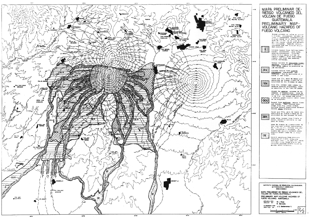
This is a zone surrounding the summit for a radius of about 3.5 km. It includes mostly places with approximately 30° slopes. It extends down farther along the principal barrancas. This area is dangerous even when the volcano is inactive, but during activity it is subject to extremely grave hazards to all living things. The area is uninhabited.
![]()
![]()
This zone occurs along principal barrancas where the slope breaks to less than 25°. Often the profile of the barranca widens and the block and ashflow materials deposit in a fan. In some barrancas, like the Río Ceniza, the channel remains constricted and the block and ashflow deposits fill the deep channel. The elevation of this zone varies, it reaches elevations as low as 800 m along the Río Ceniza, but only to 1,500 m at Quebrada San Jose. This zone appears uninhabited, except for daytime gathering and grazing.
![]()
This zone occurs downslope from III, along the same barrancas. The slope is often about 10° or less, and the lower range of elevation is variable, probably depending on the amount of material deposited in the channels upstream. The mudflows do not necessarily occur at the same time as the eruption. If the eruption occurs in the dry season, mudflows may not begin until heavy rains ensue. In the period following an eruption, the amount of block and ashflow material in a channel will indicate the magnitude of hazard down the valley. Aerial photography is suggested as a way to measure the degree of mudflow hazard in each valley. This hazard may continue for a year or more after eruptions, longer for very large eruptions.
![]()
There are large areas of laharic fans around Fuego which have not received mudflows from the most recent activity. The deposits have well-developed soils and vegetation cover. The likelihood of hazard in these areas is less than the others, but we have included them as hazard zones because only slight changes inteh pattern of pyroclastic flows could affect these areas. This is most notable in the area North of Siquinala where there is a complex fan of river valleys. It is difficult to know exactly where laharic deposition wil occur next in that area.
![]()
This includes the floodplains of rivers and the rivers they flow into. Bridges crossing these rivers are subject to wash out. The period of more frequent flooding may lat for 10 years or more following an eruption, but will eventually decline again. In some places areas may be flooded beyond floodplains and terraces, especially where one river dams another at their confluence (El Palmar Effect). Affected rivers should be periodically examined after eruptions to anticipate such problems before it is too late.
The meteorology of the area, thoroughly discussed in Flood
Control Project No. 69, indicates some specific potential damage
areas/trouble spots. These apply to the Achiguate and Pantaleon river
basins.
The most comprehensive study to date on epiclastic processes
is by Vessell and Davies (1981) on the cone
of Fuego. They divided the deposits of Fuego into four facies
associations:
(a) Volcanic core facies of lavas, air-fall deposits and colluvium breccias.
(b) Proximal volcaniclastic facies of volcanic breccias (block and ash-flow deposits, colluvium breccias) and air-fall deposits.
(c) Medial volcaniclastic facies of debris-flow deposits (lahars) and fluvial conglomerates with some air-fall deposits.
(d) Distal volcaniclastic facies dominated by fluvial sands, breccias and conglomerates, which interfaces with the coastline near Fuego.
![]()
The succession examined by Vessel and Davies (1981) was deposited in the past 20,000-30,000 years, and repeated cycles of deposits and sedimentary processes have been recognized. Three cycles, each triggered by an eruption, could be divided into four phases. These phases are presented in the following table.
![]()
From this table it is apparent that there is much more happening on volcanoes than simply volcanic eruptions. On Fuego, only eruptions producing greater than 6 x 10^7 m³ of ejecta were found to be capable of triggering large-scale sedimentary events, and the repose period between these eruptions is 80-125 yeaers. Minor eruptions with a shorter repose period do not significantly affect the sedimentary system, which proceeds as a series of short pulses. Since major eruptions betwen 1972 and 1974, at least 6 x 10^6 tonnes of volcaniclastic debris have been removed from the cone of Fuego, which at present is in a Phase 4 stage.