Connection to the Earth Science Curriculum
Essential Lessons:
1. How do you think the potholes in the
Eagle River formed?
2. What is the significance of the red
sandstone? *HINT – What makes iron rust orange-red?
Big Idea 1: Earth Scientists use repeatable observations and
testable ideas to understand and explain our planet.
Big Idea 4: Earth is continuously changing.
Glaciers were the only significant geological events to take place in Michigan.
Flooding only occurs after heavy rain.
The atmosphere, hydrosphere, lithosphere, and biosphere do not cause changes in one another; these systems operate independently on Earth.
E1.2C Develop an understanding of a
scientific concept by accessing information from multiple sources. Evaluate the
scientific accuracy and significance of the information.
E2.1B Analyze the interactions between the
major systems (geosphere, atmosphere, hydrosphere, biosphere) that make up the
Earth.
Eagle River Bridge EarthCache
Short Description:
This
EarthCache will take you to a pedestrian bridge overlooking the Eagle River in
the Keweenaw Peninsula not far from Great Sand Bay. The site has several geological features of
interest: a waterfall, a geological contact, and several potholes.
Coordinates:
Latitude: 47° 24.746'N Longitude: 88° 17.807'W
Key Earth Science Vocabulary Words:
Potholes: A
circular hole in the bed of a river produced by abrasion.
Geological
Contact: The surface along which one rock touches another. They may be
either Depositional, Intrusive, of Fault contacts.
Waterfall: A steep fall or flow of water in a
watercourse from a height, as over a precipice; cascade.
Glacier: A thick mass of ice that forms on
land from an accumulation of snow significant enough to persist through the
summer and grow year by year.
Sandstone: A sedimentary rock composed of
sand-sized particles (1/16 to 2 millimeters in diameter).
Basalt: A dark-colored fine-grained extrusive
igneous rock. It is formed when lava cools quickly on the surface.
Conglomerate: A sedimentary rock that contains
large (greater than two millimeters in diameter) rounded particles. The space
between the pebbles is generally filled with smaller particles and/or a
chemical cement that binds the rock together.
Content Explanation:
This site at Eagle River is full of interesting geological
features. The waterfall flows down a rather wide escarpment composed of a hard
dark colored basalt rock. Basalt is formed when lava cools quickly on the
surface. This area was once the site of over 400 lava flows during the
Precambrian over 1 billion years ago! (W. Rose, personal communication, July
11, 2011). Covering the basalt was a layer of red sandstone. The sandstones red
color tells us that oxygen was present in the atmosphere when the sandstone was
made. (W. Rose, personal communication, July 11, 2011) .The sandstone is more
easily eroded than the basalt and therefore much of it has been eroded by the
action of the river.
If you look closely at the bottom of the escarpment you can
see where the basalt and the sandstone layers meet. This area is called a
geological contact. Geological contacts are areas where rocks of different
formation and age come in contact with each other. On the other side of the
bridge you can see another area of geological contact between the basalt rock layer
and a conglomerate rock layer. The rock layers are tilted towards the lake. This
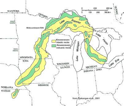
is a result of the Mid-continent rift that happened about 1.1 to 1.0 billion
years ago and caused the lava flows that formed the basalt rock. (W. Rose,
personal communication, July 11, 2011)
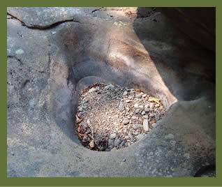
Figure
Perhaps the most interesting formation at this site are the potholes found all over the escarpment. The
formation of these cylindrical holes in the basalt is still under debate by
members of the geological community. Two major hypotheses about the pothole
formations have been proposed: 1. Bubble Cavitation and 2. Stone Scouring. (W.
Rose, personal communication, July 11, 2011). The bubble hypothesis proposes
that fast moving water contains bubbles in a vortex that smashes into the rock
forming the pothole. The stone scouring hypothesis proposes that the water used
hard rocks to scour the potholes in the parent material much like a chemist’s
mortar and pestle. Regardless of the exact method of formation it appears that
fast flowing water (most likely from glacial melt water) played a critical
role.
Figure
Logging Questions:
Q1: How many
potholes do you see that are larger than 10ft in diameter?
Q2: Standing
on the pedestrian bridge is the waterfall southeast or northwest?
Access Information:
References and Citations:
Dictionary.com (n.d.) retrieved
from http://dictionary.reference.com
Geology.com (n.d.) retrieved from http://geology.com/geology-dictionary.shtml
Hydrodynamics, Vortex, Bubble, Cavitation (n.d.) retrieved from http://video.google.com/videoplay?docid=-852140142330854418&ei=PhAvStGsAZa0-gHmjZmqCQ&q=bubble+cavitation&hl=en
Miller, M. (2010,
March 31). Geological Contacts.
Retrieved from http://pages.uoregon.edu/millerm/Srcontacts.html
Ojakangas,
R.W., G. B. Morey, J. C. Green.
2001. The Mesoproterozoic Midcontinent
Rift System, Lake Superior Region, U.S.A.: Sedimentary Geology, v. 141-142, p.
421-442. Cited in MinnesotaStuff.com ( http://www.minnesotastuff.com/Places_Maps.htm).
Rose, W. (n.d.) retrieved from
http://www.geo.mtu.edu/~raman/SilverI/MiTEP_ESI-1/Potholes.html
(Untitled photograph of pothole in coquille river falls). Retrieved August 11, 2011, from: http://www.fs.fed.us/r6/rogue-siskiyou/recreation/geology/waterfalls.shtml
Woodbury, K. (2008, Spring) Lake Superior and Keweenawan
Rift. retrieved from http://www.emporia.edu/earthsci/student/woodbury2/rift2.html