|
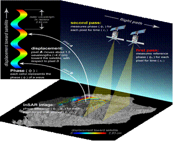
Spaceborne Interferometric
Synthetic Aperture Radar (InSAR) is a technique that slowly starting to be
utilized by the landslide community for characterizing ground movements. This technique uses SAR data from repeat
pass polar satellites (Radarsat-1, ERS-1, ERS-2, Envisat, JERS, ALOS) to
compare changes in phase that relate to ground deformations.
|