Bigger River?
Was a bigger river here once?


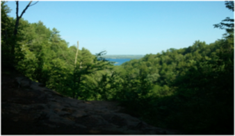
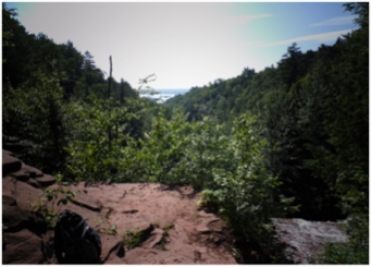
Observe the surrounding area and you get a wonderful view of the valley that has formed as the Dover Creek winds towards Torch Lake below. A valley is a depression in Earth’s surface that extends in a certain direction. Often times a valley is also referred to as a gorge or canyon. A gorge is a valley with steep cliffs and a waterway running at its base. In geology the terms gorge and canyon are used interchangeably as they are essentially describing the same basic feature. So how did this beautiful landscape come to exist? Was there a larger river found here at one point in time creating this gorge? Are glaciers the cause of this majestic view?
The Last Ice Age
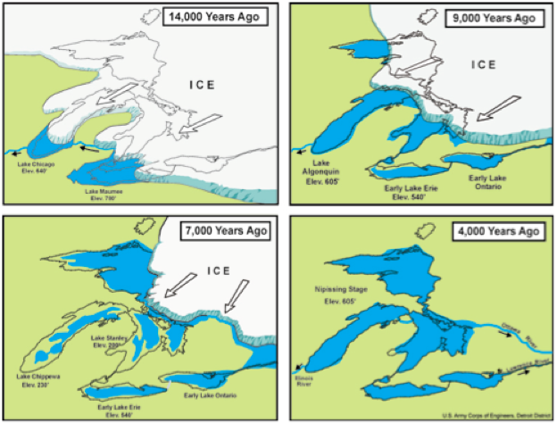
Michigan was greatly impacted and shaped by glaciers. These huge ice sheets, many times miles in thickness, covered much of Michigan during the ice age. There were four major periods when these massive glaciers advanced over the area we now know as Michigan, carving and shaping the landscape. Each time a glacier advanced over the area it would scrape and almost clear any features that were found before it. This meant each time the glacier receded it left a different looking Michigan. This is why we will focus on the last glacial period which occurred about 10,000 years ago. As this glacier receded it produced a huge amount of melt water that filled the varying waterways leading from the glacial to lower areas. Due to the Keweenaw fault that is found running through the middle of the Keweenaw Peninsula that can be observed at the upper falls the water would have flowed from the fault towards the southeast and what we now know as Torch Lake.
How a Gorge Forms
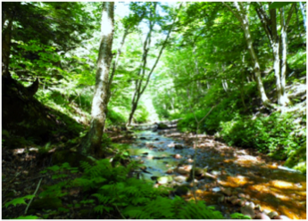
Gorges are formed through the interaction of a couple processes. The simple and most evident process is that of erosion by the moving water. As water runs through the waterway it contains a large amount of force. The energy of this moving water is continuously cutting away and deepening the creek bed. During times of increased water flow, like that which would have occurred during the glacial melting, more water is moving through the waterway greatly increasing this erosional force and thus digging the channel of the waterway much deeper. As the waterway becomes deeper the walls become steeper. These very steep slopes begin to feel the effects of gravity and erosion themselves. As rain and snow are introduced to the area the water seeps into the banks making the area softer and more susceptible to gravity. These heavier and weaker slopes then fall or slide to the waterway below creating what you see as the valley with a very distinct V-shape. This process continues to occur even during times of lower water flow; however it is occurring at a much slower rate than times of increased water flow. Erosion by both the moving water in the creek bed along with the erosion of the slopes due to rain and gravity pair together to increase or widen the gorge perpendicular to the water flow of the creek.
Waterfalls also have an effect on the migration of the gorge upstream or parallel to the water flow. As described at the middle falls the formation of a plunge pool creates a situation where undercutting weakens the base of the falls and eventually collapse of the upper layers into the creek. When this occurs it will move the waterfall upstream and thus increasing the size of the gorge. To learn more about the formation of plunge pools you may click the link found here or visit the middle falls on the Hungarian Falls Geo Tour.
Question:
What clues are there to support that erosion is a continual process?
What evidence could you use to support or refute a claim that this valley was formed by glaciers during the last ice age?
This work was supported by National Science Foundation award #0831948.
Different Shapes
So how can you know if a gorge is one produced by flowing water versus one formed by a glacial activity? To answer this in a simplified way geologist often observe the shape of the valley or gorge. When looking at the slope of the walls of the gorge you will observe an overall U-shape or a V-shape. Glaciers tend to create a U-shaped valley or gorge that is often littered with boulders and other rocks that were transported and left by the glacier as it receded. On the other hand a valley or gorge produced by flowing water has a V-shape with the sediment that has been eroded from the walls to the bottom of the gorge into the flowing water and eventually being deposited in a floodplain at the end of the waterway, in this case downstream by Torch Lake.


Stats
name Bigger Valley?, Hungarian Falls
location Hubbell, Michigan
KMZ download HungFallsGTour.kmz
subjects Misfit Stream
Author Joshua Ernstes
1. The Fault 2. Dam 3. Crossbedding 4. Potholes 5. Plunge Pool 6. Bigger River? History