Raspberry Island
 

At Raspberry Island, about 0.5 km (0.3 mi) SE of Rock Harbor Lodge, we spend the day looking at a remarkable set of exposures nearby that provide an impression of some of the solidification features of an ophitic flow (approximately 20-30 m thick). This decade, in increasing amounts, low lake levels have made these exposures more numerous and accessible.


A loop trail goes around the W half of the island, marked by informative signs about the unique ecosystem of this island, which features frequent fog and damp, moss-rich swamps. Among the unusual plants is the pitcher plant (Sarracenia puerperia), which is an insectivorous plant that flourishes in the swamp along the loop trail.

First, we will visit the W end of the island, where the regional attitude of the lava flows is seen in the view along strike toward Smithwick Island across the Smithwick Channel. The point facing the channel on Raspberry Island is underlain by the oldest of the three flows on the island. We will walk on a dip slope that shows some of the jointing pattern we observed on the SE sides of Davidson and Smithwick Islands. Next, we will head to the SE corner of the island to observe some rude columns in the uppermost Raspberry Island flow.

Smithwick I
3 flows dip SE

Here at Raspberry Island, exposures of vesicle cylinders show a regular spacing between them, 1-3 m (3-10 ft.) apart, and a marked variety of textures; some were evidently preserved almost as voids, while others are filled with material that closely resembles vesicular pegmatoid. An interesting aspect of the exposures here is the relationship between the ophitic textures of the flow and the vesicle cylinders: The grain size of oikocrysts seems to be influenced by the proximity to the vesicle cylinder.

Vesicle cylinders (Goff, 1996) are found mainly in only two areas along this shoreline. This may reflect their restricted occurrence in a thin part (less than a few meters thick) of this flow. Based on limited field examination, this thin part seems to be in the lower part of the flow. The comparisons between this occurrence and written descriptions, by Paces (1988) of the PLV on the Keweenaw, by Marsh et al. (1991) of solidification in sheet-like basaltic bodies, and those from Hon et al (1994) and Self et al 1998 are illuminating.
These descriptions show the vesicle cylinders as developing in the upper part of the lower capture front of a solidifying body and continuing upward to the liquid zone. This suggests that the segregations formed during solidification--when the region around the cylinders was mushy. The vertical movement of the cylinders was accommodated by the positive thermal gradient and by more fluid material that overlay the mush region. Also see Flow Structure Section)


Slickenside Surfaces

Featured conspicuously along the E shore of Raspberry Island are slickenside surfaces. A study of the fault slickenfibers allowed Witthuhn-Rolf (1997) to use geometrical and statistical methods to define the kinematics of the closing of the rift.


In Witthuhn-Rolf's study, Raspberry and Edwards Islands offered one of the largest populations of measurements.  The measurements revealed two consistent stress fields, for each limb of the syncline, that would satisfy the conditions envisioned for the opening and closing of the Midcontinent rift. Most of the faults on Isle Royale, including both normal and reverse faults, trend NE. This suggests that the reverse faults represent reactivated normal faults. The orientation of reverse faults at Isle Royale differs significantly from the predominately N-S trending structures measured in the PLV on the Keweenaw Peninsula.


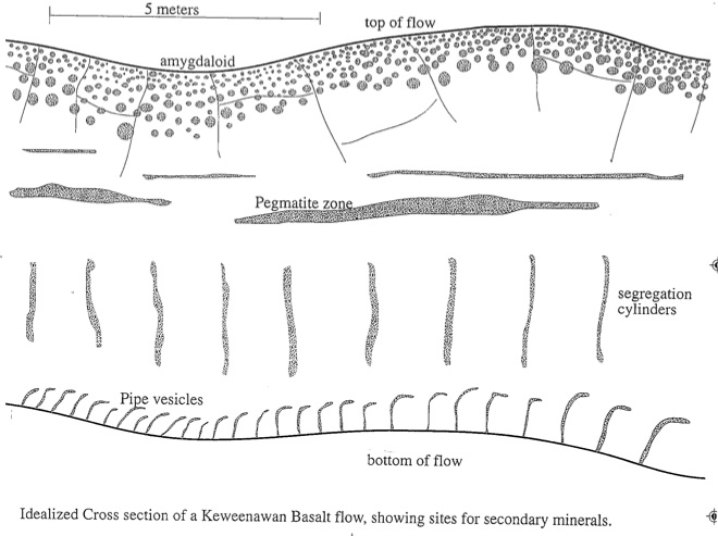
Pegmatoid Zones (see also Pegmatite)

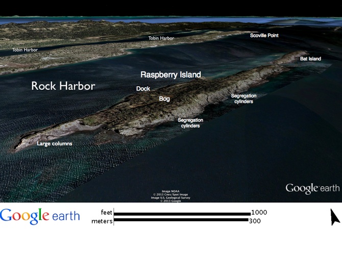
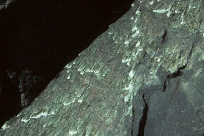
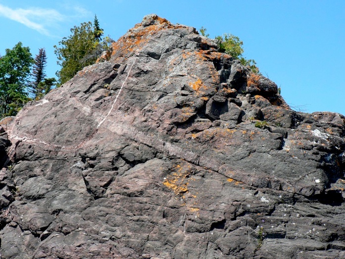
About two-thirds of the way along the shore of Raspberry Island, the exposures that occur are stratigraphically higher in the flow. Here the flow has a laminar structure that consists of fractures that are parallel to the bedding and spaced about 0.5-3 cm (0.2-1.2 in) apart. Within this part of the flow, vesicle cylinders are not seen, but small pegmatoid lenses occur. Paces (1988) describes them:

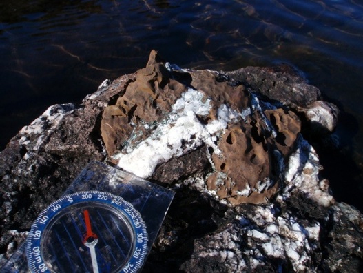
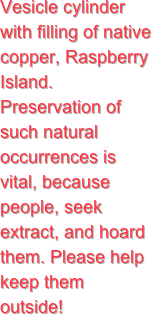
Pegmatoid horizons are similar to vesicle cylinders in that they consist of gas-rich, coarsely crystalline, granophyric material. However, they occur as discontinuous lenses and layers, typically 10 em (4 in) to several meters thick, and are usually located between the flow top and most massive portion of the flow interior. Pegmatoids are best developed in thicker flows that have cooled slowly enough to allow in situ differentiation (Cornwall 1951; Lindsley et al. 1971). This material represents the last remaining volatile-rich liquid, which is injected into fractures oriented sub-parallel to the upperflow surface. Both vesicle cylinders and pegmatoid layers contain significant void space in the form of vesicles and gas pockets and contribute to the permeability of the lava flows.

--Paces 1988

The origin of the pegmatoids is likely related to the process by which the vesicle cylinders were formed. However, for the pegmatoid origin, the rise of material in channels is limited by the thermal gradient and by the associated solidification that happens above the zone of pegmatoids, so the material is blocked and accumulates in lensoid layers (Figure 30).

It is possible that Keweenawan flows preserve the inflated nature of ponded flood basalts well because runout of inflated flows such as can occur on sloping volcanoes is prevented by the rift-filling geometry.

Vesicle or Segregation Cylinders

On the wave-washed SE shore are two zones of exposures of vesicle cylinders. Paces (1988) describes vesicle cylinders (Goff 1996) in the PLV:

Vesicle pipes are elongated, tube-like structures, 10-30 cm (4-12 in) in diameter and 0.5-2 m (1.6-6.6ft.) in length, containing somewhat coarser and more prismatic crystals compared to the adjacent groundmass. They are oriented vertically and occur predominantly in the bottom half of the flow. The origins and dynamic behavior of vesicle cylinders are poorly understood; however they appear to represent an accumulation of exsolved magmatic gas bubbles which migrate upwards through the magma during the period when the cooling magma behaves as a Bingham plastic (i.e., possesses a finite yield strength, Walker 1987).

--Paces 1988

 
Dip Slope
Anti-dip Slope

One of many small islands along the S side of Rock Harbor, Raspberry Island is three ophitic flows of the undivided PLV (pu) dipping 15° SE. The uppermost of these flows is extensively exposed on a wave-washed dip slope. This shoreline receives strong storm waves and, fortunately has wave-washed exposures about 1 km (0.6 mi) long. They expose the flow interior, the top is eroded and the base of the flow is buried.

Fraser Goff
Bat Island
Vesicle cylinder with filling of native copper, Raspberry Island.  Preservation of such natural occurrences is vital, because people, seek extract, and hoard them. Please help keep them outside!