Research and Current Projects
Main themes: Earth/climate interactions,
remote sensing of volcanic emissions, natural hazards.
|
|
|
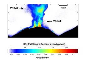
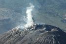
Ultraviolet image
of Santiaguito volcano and SO2 plume, taken with a new camera
developed at Michigan Tech (January, 2005). RESEARCH
ACTIVITIES Remote Sensing for Hazard
Mitigation and Resource Protection in Pacific Latin America (Project Web
Page). This
project is supported by NSF's Office of International Science and
Engineering, and will extend from September 2005 to August 2010. This project
focuses on developing remote sensing tools for collaborative hazard
mitigation and resource development in Guatemala, El Salvador, Nicaragua and
Ecuador. This project has support for post-docs, Ph.D. and M.S. students each
year. Undergraduate work in
Central America is also supported for MTU’s “Aqua Terra Tech” Enterprise and
the Remote Sensing Minor. ●Development
and Application of an SO2 Imaging Ultraviolet Camera for Volcanic
Gas Monitoring (2005-present). With support from NSF's Petrology and
Geochemistry Program, we have developed a UV digital camera system for
imaging volcanic SO2 plumes with high sensitivity, the ability to
derived plume speeds directly from sequential images, and quantify SO2
fluxes under a variety of environmental conditions. We continue this work towards developing the camera as a
practical, reliable monitoring tool. ●A New Long-Term Record of Volcanic SO2 Generated From
HIRS/2 Satellite Data. This project is supported by NASA's Solid Earth
and Natural Hazards Program, and is planned to extend from September 2003 to
August 2006. We are analyzing infrared satellite data, and developing
techniques to study volcanic clouds and a database of volcanic SO2 emissions
from this method, complementary to the ultraviolet TOMS sensor. This project
has support for 1 Ph.D. student. (full
proposal) ●Validation of TOMS Volcanic Aerosol and SO2
Products Using MODIS and AVHRR(2001-2005). This project is supported by
NASA's Earth ●IDL Programming Tutorial (2002): this is a
fairly rigorous introduction to applied science programming. This work was
supported by a 2002 ●Volcanic Hazards Products for the Pacific
Disaster Center (PDC) (1999-2002): This research focuses on the formation
and tracking of volcanic fog (vog) in the state of ●The Center of Environmental Remote Sensing
Education for Engineers and Scientists at Michigan Tech(1998): through
the ●Natural Hazards Mitigation using the Total Ozone Mapping
Spectrometer (TOMS) (1998-2001): An update of this project where we are
using TOMS SO2 data to study long term volcanic emissions, and the fates of
these emissions in the atmosphere. ●Tropospheric Aerosols (1993-1997): In this
project we used TOMS SO2 data to study the contribution of volcanic activity
to the atmospheric sulfur dioxide budget. This NASA-funded project has
supported several student projects, at both M.S. and Ph.D. levels. ●Some
of my work with NASA/Goddard can be seen on the TOMS/SO2 Volcano Group Web
page |
|
|
|