
Any use of trade, product or firm names is for descriptive purposes only and does not imply endorsement by the Government of Montserrat.
Introduction
Introduction
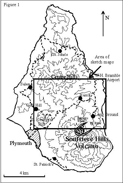
At about 12:55 (all times within this report are local time) on
Wednesday 25 June, 1997, a pyroclastic flow commenced from the lava dome
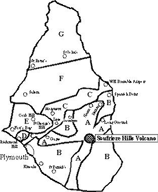
in the crater of the Soufriere Hills volcano (Figure 1). In the
following 25 minutes, a series of devastating flows swept the northern
flanks of the volcano, down Mosquito Ghaut and followed the Paradise
River almost to the sea. The flows and associated surge clouds damaged
or destroyed between 100 to 150 houses, with the villages of Streatham,
Dyers, Harris, Bethel, Bramble, Trants, Farms and Spanish Point being
severely affected. At the time of writing 8 people are confirmed dead,
and a further 11 are missing. Five people also suffered serious burns.
Figure 1 - Small GIF - Larger GIF - Postscript
The pyroclastic flows were the largest produced during the current
eruption, and the intensity of the activity exceeded that of the
explosion of 17 September 1996. An estimated 4 to 5 million cubic metres
of the lava dome were unloaded during the event, and the flows and
surges covered an area of 4 square kilometres. An ash cloud rose to
about 10 km, and ash fell over western Montserrat.
2. Precursory activity in the previous weeks
Observations
Rockfalls and rapid degradation of the north face began on 14 May after
approximately two-and-half months of relative stability. The rockfalls
intensified over a few days and by 19 May material had overspilled into
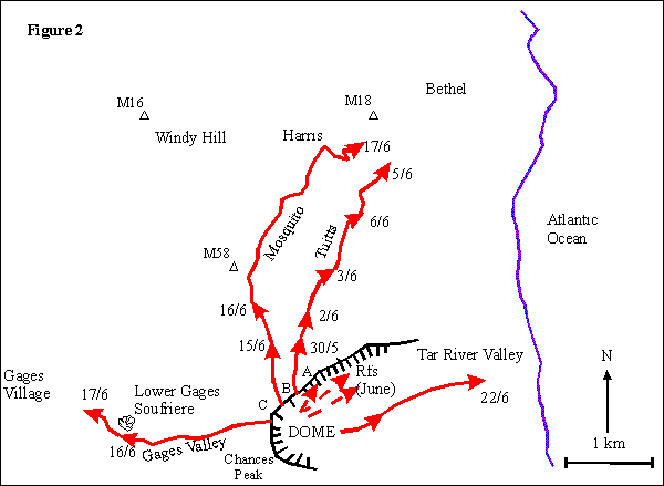
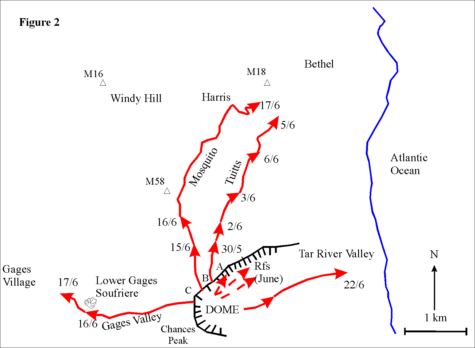
the head of Tuitt's Ghaut. Pyroclastic flows into the northern ghauts
began on 29 May with a minor flow into Tuitt's Ghaut. The size of
subsequent flows into Tuitt's Ghaut increased in early June and the
activity was followed by flows into Mosquito Ghaut and Gages Valley in
mid-June (Figure 2). Many of the rock samples collected from the 17 June
pyroclastic flow into Mosquito Ghaut were moderately vesicular and are
interpreted to be juvenile material.
Figure 2 - Small GIF - Larger GIF - Postscript
Observations in the week prior to 25 June showed that dome growth was
concentrated in the summit area.
Unfortunately, the extrusion rate for June is poorly known due to low
visibility, although it is likely to have been elevated because the
volume of the dome as determined from a survey conducted at the end of
May was higher than usual (65 million cubic metres; extrusion rate of
3.5 cubic metres per second). The dome had filled English's Crater,
threatening the northern slopes of the volcano for the first time.
Seismicity
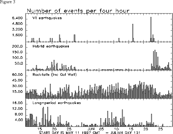
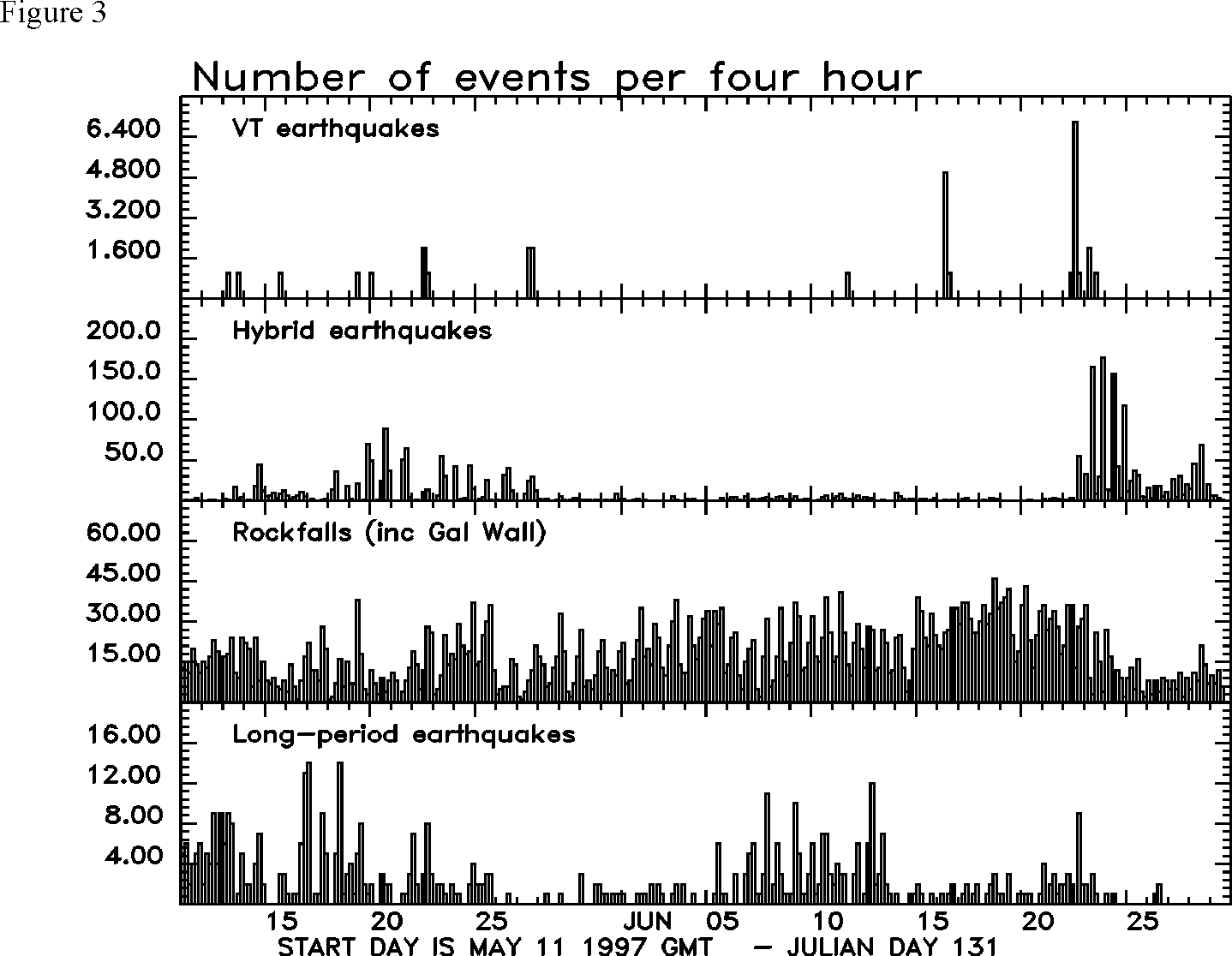
Hybrid earthquake swarms occurred during 13 to 27 May, with swarms
comprising about 100 earthquakes per day of varied sizes. Unlike
previous hybrids swarms , the activity did not consist of repetitive,
identical events. Each swarm of earthquakes was followed immediately by
a period of enhanced rockfall activity. When the earthquake swarms ended
on 27 May, the pattern of regular periods of enhanced rockfall activity
continued (Figure 3).
Figure 3 - Small GIF - Larger GIF - Postscript
Following pyroclastic flow activity on 5 June in Tuitt's Ghaut the
character of the seismicity changed slightly, with more long-period
earthquakes recorded. The number of earthquakes remained quite low, not
exceeding 40 per day, and the long-period earthquakes returned to normal
levels after 13 June.
Hybrid seismicity restarted suddenly on the morning of 22 June. This
followed a moderate pyroclastic flow in the Tar River valley, and a
small swarm of volcano-tectonic earthquakes. VT earthquakes have been
rare in recent months, usually occurring in single swarms.
There were 7 hybrid swarms between 22 and 25 June. The swarms gradually
increased in duration and numbers of earthquakes. Within each swarm, the
earthquakes were repetitive and had generally similar magnitudes, with a
few larger earthquakes in each swarm. The maximum magnitudes were
relatively small; much higher magnitudes had been recorded previously.
The swarms on 24 and 25 June showed increasing intensity, reaching a
state where repetitive events merged into continuous tremor that was
difficult to distinguish from rockfall signals on the drum records.
The tendency for enhanced rockfall activity at the end of the hybrid
earthquake swarms continued, although the intensity of these events
generally decreased.
Deformation
Deformation monitoring at the Soufriere Hills Volcano by the MVO
involves a combination of Total Station measurements (combined
electronic distance measurement (EDM) and theodolite) and global
positioning system (GPS). Crack dimensions in the crater walls are
monitored by frequent measurements between fixed points on opposite
sides of the cracks. Continuous telemetered data are collected from two
tiltmeters and one extensometer installed on Chances Peak and a
tiltmeter in Long Ground.
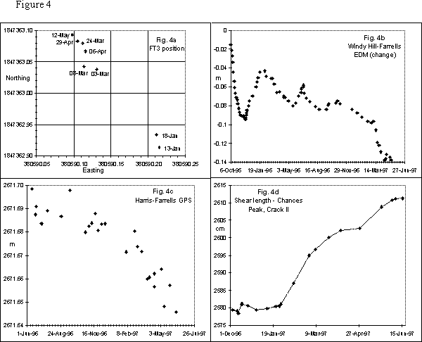
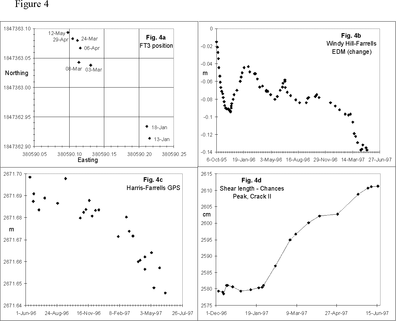
Deformation of the northern crater wall was first observed in early
March 1997 by GPS surveys. The FT3 station on the crater wall (Peak C on
Figure 2) had moved 15 cm to the north-west between 13 January and 3
March. Subsequently, more regular monitoring indicated continued motion
to the north-west, with the total displacement reaching 21.5 cm by 12
May (Figure 4a) after which the site was considered too dangerous to
visit. GPS occupations on the summit of Chances Peak (Figure 2) since
July 1996 have also shown sustained motion away from the dome. Total
displacement is currently 16 cm.
Figure 4 - Small GIF - Larger GIF - Postscript
An EDM/GPS station at Farrells has shown slow movement to the north away
from the dome complex (Figures 4b and 4c). Shortening of 5 cm occurred
in the early stages of the eruption (up to 30 November 1995). Through
1996 two lengthening and shortening cycles developed, but since Dec 1996
movement has been sustained shortening on baselines to Windy Hill and
Harris. The shortening has been at an increasing rate until the last
measurement on 10 June. Long Ground underwent a slow eastwards movement
of around 30 mm up to late April, after which it underwent a relatively
abrupt displacement to the north-north-east by 25 mm. Displacement
vectors for Farrells and points on the crater wall have been reported in
the MVO Scientific Reports series (e.g., Scientific Report 64).
Crack measurements have been made on Chances Peak and Galway's Mountain
since 4 December 1996 and March 25, 1997, respectively. The Chances Peak
cracks showed rapid shear in early December (crack I only), mid-February
and through May (Figure 4d). The total shear is currently 31 cm on
Chances crack II. The Galways crack sheared by 29 cm between 3 May and
16 June. The sense of movement indicates displacement of the Galway's
Wall region away from the dome complex and demonstrates the extreme
stress placed on the crater walls in an area of the dome that showed no
surface activity at the time.
Prior to 16 June the Chances Peak tiltmeter showed a regular pattern of
inflation and subsequent deflation, directed at the dome, with a period
between 12 and 16 hours and an amplitude between 18 and 25 microradians.
From early morning 16 June to late evening 17 June, the
inflation-deflation cycle flattened to an amplitude between 5 and 10
microradians. At approximately 16:00 on 17 June, the inflation increased
steeply, peaked at 21:00, and then rapidly deflated. This deflation
preceded a collapse at 23:30 that sent pyroclastic flows 2 km down Gages
Valley and 3.5 km down Mosquito Ghaut. The pre-16 June pattern returned
for approximately 1.5 days after this event. On 19 June, the flattened
pattern returned and persisted until the morning of 22 June.
At 05:30 on 22 June, a sharp increase in the rate of inflation occurred.
Subsequent, sharp deflation at 06:30 was coincident with sustained
pyroclastic flows which travelled approximately 1 km down the Tar River
Valley. This event marked the beginning of a new pattern in the
inflation-deflation cycles. The periodicity of the cycles shortened to 8
hours. and the amplitude increased to approximately 40 microradians. The
change was accompanied by a short volcano-tectonic earthquake swarm
which preceded the resumption of hybrid earthquake activity (see above).
The number of hybrid earthquakes varied nearly exactly in phase with the
inflation-deflation cycle, with the maximum number of hybrids occurring
at the peak inflation.
Following the 25 June pyroclastic flow activity, the inflation-deflation
cycle continued with the same period and amplitude which began 22 June
until 5 July. Thereafter the amplitude decreased and the period
increased until there was no discernible cycle after 12 July. No major
pyroclastic flows occurred after 5 July (until the time of writing, 27
July).
The overall trend of the tiltmeter, prior to 25 June, showed a general
inflation to the north or deflation to the south. Since 25 June, the
trend shows a general deflation toward the centre of the dome.
3. Events of 25 June 1997
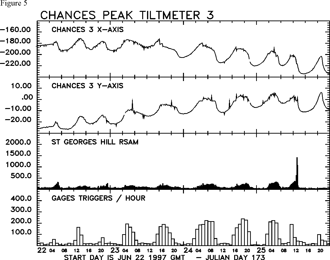
The hours prior to the Event:
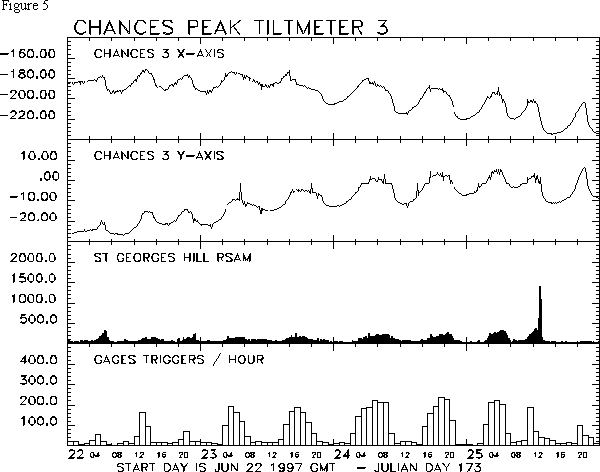
At 03:00 a hybrid earthquake swarm began, which was similar in character
to the swarms of the previous four days (Figure 5). At the maximum
intensity, 4 to 5 events occurred per minute. The earthquakes were of
moderate amplitude, reaching saturation on the Gages and Windy Hill drum
records. The Chances Peak tiltmeter continued the previous pattern, with
relative inflation of the crater area accompanying the hybrid swarm
(Figure 5). The tilt levelled out at 05:20, and the volcano started to
deflate at about 06:10. The swarm diminished gradually after about
06:15, with the hybrids giving way to low-level tremor at 07:05.
Figure 5 - Small GIF - Larger GIF - Postscript
Rock falls and minor pyroclastic flows commenced, fitting the
established pattern. Between 06:15 and 07:15 the activity was dominated
by semi-continuous pyroclastic flows travelling down Mosquito Ghaut with
run outs of ~ 1 km. There were also simultaneous rockfalls and small
pyroclastic flows from the south-east and east face of the dome.
Re-inflation of the dome area began at approximately 09:00. The seismic
activity remained at low levels until 10:50, at which time a second
hybrid swarm started. The intensity of this swarm escalated rapidly,
reaching about 6 events per minute between 11:30 and 12:30. The
earthquake amplitudes were uniform, and similar to those in the earlier
swarm. At 12:00 the inflation trend peaked. By 12:45 the seismic record
was dominated by tremor, and hybrid earthquakes were barely discernible.
A dilute steam and ash cloud issued from the summit area, which was
carried to the west by prevailing winds at an approximate altitude of
4,500 ft.
The Main Event:
Between 12:40 and 12:50 the tiltmeter registered the start of a sharp
deflation. A strong seismic signal began at 12:55, with intensified
pulses of activity at 12:57 and 13:00. At about 13:00, a dense, dark ash
cloud rose vertically from the north flank of dome above Mosquito Ghaut.
The cloud reached 30,000 feet in a matter of minutes. At 13:03 the
eastern stations of the seismic network stopped transmitting data,
because the Bethel telephone exchange (and/or the phone line across the
central corridor) was destroyed by a pyroclastic flow travelling down
Mosquito Ghaut. There was a third pulse of seismic activity at 13:08.
MVO staff positioned north of the airport witnessed the front of the
flow coming around the bend at Pea Ghaut, just up-slope of Trant's
village. At 13:15 MVO observers flying over the airport found that the
initial pulse had overrun the lower part of Harris, Farm and Trant's,
and had come to within 50 m of the sea. They also reported a final pulse
coming down Paradise Ghaut and surges continuing to spread slowly
westwards in the Spanish Point area. The final pulse of activity
advanced at approximately 30 m/s across the flat land near Trants, and
was captured on film by a time-lapse video recorder at the airport
control tower.
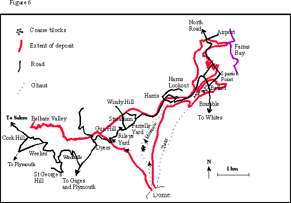
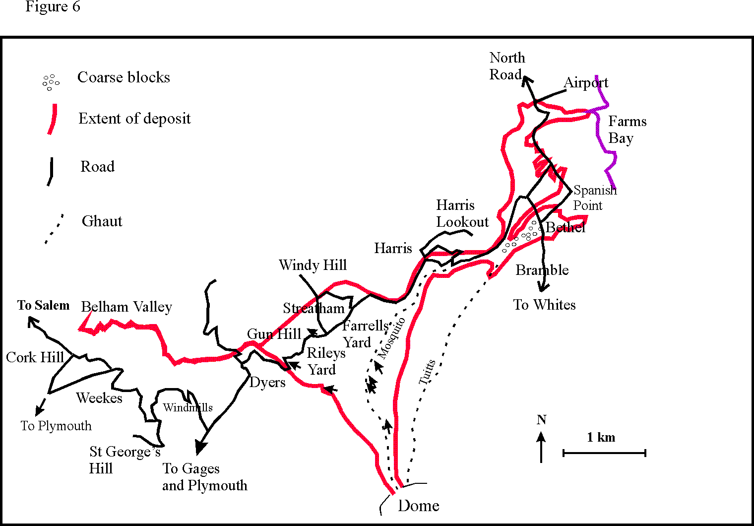
Observations of the deposits and destruction of the area (Figure 6)
include the following points:
Figure 6 - Small GIF - Larger GIF - Postscript
The elevated seismic signal persisted until 13:18, and the large
deflation recorded by the tiltmeter bottomed out at 14:30. Low amplitude
tremor with hybrid earthquakes continued until 15:00, at which time the
seismicity dropped to background levels.
The RSAM peak for the event lasted for 30 minutes, indicating shorter
but more intense activity relative to the explosion of 17 September
1996. More than 4 square kilometres were inundated by pyroclastic flows
and ash surge deposits. The estimated 4 to 5 million cubic metres of
material unloaded during the event left a steeply-dipping, circular scar
roughly 200 m across in the north-north-west face of the dome. There was
no evidence of explosive activity on 25 June. Ash fall was limited to
areas west and north-west of the volcano. Maximum accumulations reached
2 mm.
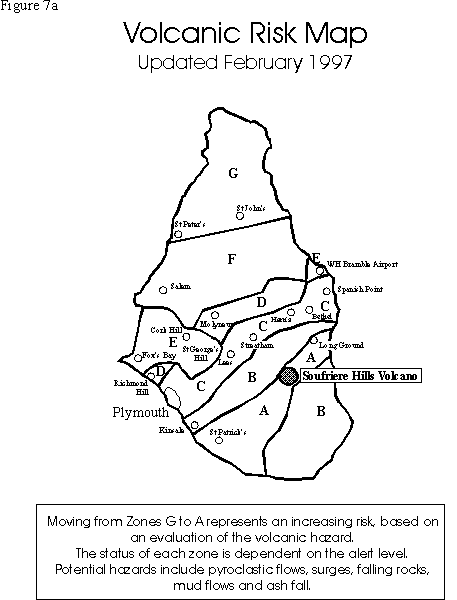
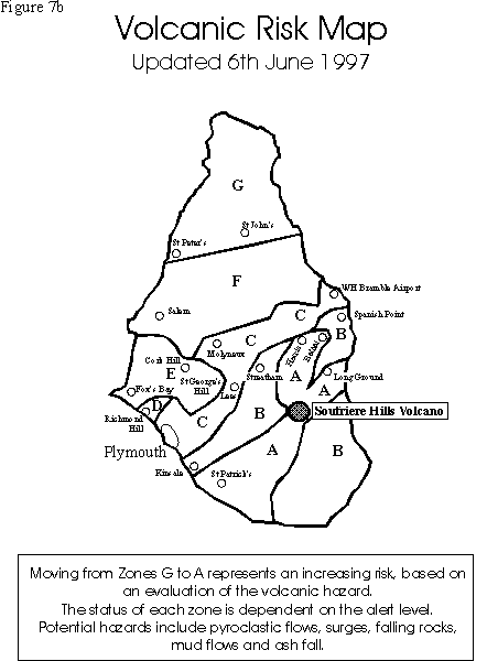
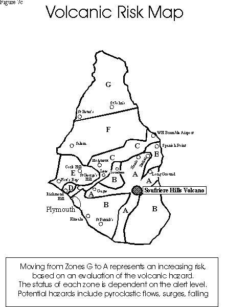
| Figure 7a | Figure 7b | Figure 7c |
| Updated February 1997 | Updated 6th June 1997 | Updated 24th June 1997 |
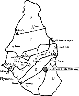 |
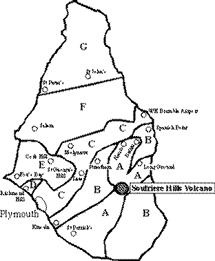 |
 |
| Small GIF - Larger GIF - Postscript | Small GIF - Larger GIF - Postscript | Small GIF - Larger GIF - Postscript |
| Moving from Zones G to A represents an increasing risk, based on an evaluation of the volcanic hazard. The status of each zone is dependent on the alert level. Potential hazards include pyroclastic flows, surges, falling rocks, mud flows and ash fall. | ||
The surge into Dyer's Ghaut and the Belham River valley was remarkable, in that a relatively fine-grained, low volume (approximately 100,000 cubic metres) flow travelled a significant distance from the main flow path.
It is interesting that the activity continued at a high level in the days following the June 25 event. This contrasts with previous periods of enhanced activity at the Soufriere Hills volcano, in which significant dome collapse events have normally been followed by a respite in activity and a change in the eruption pattern.
Appendix 1: Time line summary
Appendix 2: Emergency actions on 25 June
Figures
Appendix 1: Time line summary

3 March Displacement of point in north crater wall (FT3) of 15 cm since 13 Jan.

12 May Displacement of FT3 of 21.5 cm since 13 Jan.

14 May Beginning of rock fall activity on north face of dome.

19 May First rockfall spills into Tuitt's Ghaut.

29 May First pyroclastic flow activity in northern ghauts

2 June Pyroclastic flow down Tuitt's Ghaut travelling 1 km from the crater.

3 June Pyroclastic flow in Tuitt's Ghaut travelling 1.4 km.

4 June Pyroclastic flow in Tuitt's Ghaut travelling 1.8 km.

5 June Pyroclastic flow in Tuitt's Ghaut travelling 2.9 km, reaching to
250 m above where the ghaut joins Paradise River.

7-14 June Rockfall and pyroclastic flow activity concentrated in Tuitt's
Ghaut.

15 June Significant changes in Mosquito Ghaut. Pyroclastic flow material
advanced 500 m down the ghaut. Debris from a small rockfall in Gage's Valley.

16 June Pyroclastic flows in Gage's Valley travelling 1.6 km from the crater
rim. Smaller pyroclastic flows occurred in Mosquito and Tuitt's Ghaut.

17 June Significant pyroclastic flow activity in Mosquito Ghaut to a
distance of 4 km. Lesser activity in Gage's Valley with pyroclastic
flows travelling 200m further than previously.

22 June Moderate pyroclastic flow in Tar River followed by a short
volcano-tectonic earthquake swarm and resumption of hybrid earthquake
swarm activity

24 June Small pyroclastic flows down Mosquito Ghaut for the first time
since 17 June, travelling 1 km from the crater rim. Focus of dome growth
confirmed at top of Mosquito Ghaut.

25 June
	03:00 Start of hybrid earthquake swarm
	06:00 to 08:00 Deflation accompanied by small pyroclastic flows in Mosquito Ghaut
	10:50 Start of hybrid earthquake swarm
	12:00 Crater inflation peaked
	12:45 Volcanic tremor, steam and ash production
	12:55 Start of pyroclastic flow activity
	12:57 First pulse in seismic activity
	13:00 Second pulse in seismic activity
	c. 13:00 First pyroclastic flow observed in Mosquito Ghaut from MVO
	13:02:12 First flow seen from airport around Harris Hill (didn't get much further than Farms)
	13:03 Seismic signals from eastern stations lost
	13:07:40 Second pulse seen from airport (probably reached furthest run-out distance)
	13:08 Third pulse in seismic activity
	13:13:49 Third pulse seen from airport (distinct pulse of co-ignimbrite ash through cloud of second pulse)
	13:20 End of seismic activity
07:00 to 08:00 Heightened concerns about possible pyroclastic flow
activity. MVO observer at airport alerted. Police HQ contacted, advised
to keep checkpoint to Plymouth closed for the time being (it later
transpired that essential services were already working in Plymouth,
without the knowledge of the duty scientist). MVO observers deployed at
Windy Hill to observe small pyroclastic flows in Mosquito Ghaut.

08:20 Police Commissioner advised that checkpoints into Plymouth can
open, and essential services allowed access.

12:30 Police Commissioner visits MVO, briefed by Chief Scientist (CS).
Check points into Plymouth closed.

12:45 Deputy Chief Scientist (DCS) arrives at MVO. CS / DCS discuss
situation. Duty scientist at airport put on alert.

12:45 to 12:55 Essential services in Plymouth advised to evacuate. Port
Authority, Monlec, Montserrat Mills contacted successfully but direct
contact with Texaco fuel tanker not made (the tanker later cut the fuel
lines to the port and successfully withdrew). Plymouth siren sounded.
Live update of situation broadcast on Radio Montserrat. Field team at
Whites advised to speed up operation. Field team requests permission to
enter central corridor area, refused by CS and advised to withdraw to
airport.

12:55 Start of pyroclastic flow activity

c. 12:58 Phased evacuation of airport recommended by MVO.

c. 13:00 Immediate evacuation of airport initiated. Staff clear of
airport in less than 5 minutes, plane on ground takes off. HE the
Governor at airport, accompanies MVO scientists to safe viewing position
north of the airport.

c. 13:00 Acting Governor, Chief Minister, Minister for Education and
Health, Minister for Agriculture, Trade and Environment arrive at MVO
for briefing.

c. 13:00 Two MVO staff members take off from Vue Pointe in helicopter.

c. 13:10 All MVO staff accounted for and confirmed safe.

c. 13:15 Acting Governor, etc. leave MVO for Emergency Operations Centre
(EOC), accompanied by DCS and Dr Baxter.

13:16 Helicopter reconnaissance over the airport picks up survivors in
the Trants area.

13:20 Ash advisory issued by MVO. Due to phone line problems, fax
reached only 2 of 5 intended recipients.

14:00 Helicopter searches for survivors in Spanish Point area.

14:45 Survivors sighted in Harris, evacuation initiated by MVO
helicopter.

15:06 Search and Rescue team approaching from west by road report hot
ash at Dyers.

15:14 Hot ash reported by Police in Bellham Valley near Cork Hill

16:00 CS briefs authorities at EOC of current situation
The figures are available in a small image format (usually 600x400 GIF), a large image format (usually 1200x800 GIF), and Postscript