MVO LOGO

Montserrat Volcano Observatory, Montserrat, West Indies


Special Report 02
Deformation of the Galway's Wall and Related Volcanic Activity,
November 1996 to March 1997

Simon R Young, Jenni Barclay, Angus D Miller, R Steve J Sparks,
Rod C Stewart, Mark A Davies and MVO staff

Individual author affiliations

Any use of trade, product or firm names is for descriptive purposes only and does not imply endorsement by the Government of Montserrat.


  1. Summary
  2. Visual Observations
  3. Seismicity
  4. Deformation
  5. Volcanic Hazard and Alert Levels
  6. Discussion
    List of Tables
    List of Figures

1. Summary

Between October 1996 and March 1997 the Galway's Wall, part of the southern confining wall of the crater of the Soufriere Hills volcano, underwent deformation and erosion which resulted in the gradual collapse of the upper part of the wall and overtopping by the lava dome. Between mid-October and mid-December 1996 the wall showed signs of denudation and increased instability, characterised by the development of fractures across the wall and landslides from its outside face. The visible signs of deformation were accompanied by intense, shallow earthquake activity, with the peaks in deformation and seismic activity occurring when dome growth slowed or stopped. At the peak of deformation in early December there was about 100 m of endogenous uplift of the south part of the lava dome, adjacent to the Galway's Wall, and this was followed by the extrusion of a new dome starting on about 11 December. Thereafter the volcano entered a phase of rapid dome growth, with the highest sustained rates of extrusion experienced during the eruption, while the deformation of the Galway's Wall slowed. In late January 1997, the rate of deformation increased again as dome growth slowed, accompanied by more intense shallow seismicity and periods of volcanic tremor, and the rapid erosion of the top of the wall. Material from the lava dome fell over the wall in gradually increasing amounts from 1-2 February, until 30 March when the first significant pyroclastic flows occurred in the White River valley, which drains the base of the Galway's Wall. The deformation and partial collapse of the Galway's Wall was probably caused by a shallow intrusion behind the base of the wall during periods when the lava was unable to reach the surface.

2. Visual Observations

Introduction and geology

The Galway's Wall is located on the south side of English's Crater (Figure 1). The geology of the wall is quite complex with interleaved pyroclastic breccias from the Chance's Peak and Roche's Mountain domes, intrusive sheets and stratified tuffs. These overlapping sequences are cut by at least three faults or large fractures. Some of the older pyroclastic deposits have been either weathered or altered by hydrothermal activity, particularly at the top of wall and in gullies that may be associated with faulted contacts (Figure 2).


Special Report 02, Figure 1

Small GIF - Larger GIF - Postscript

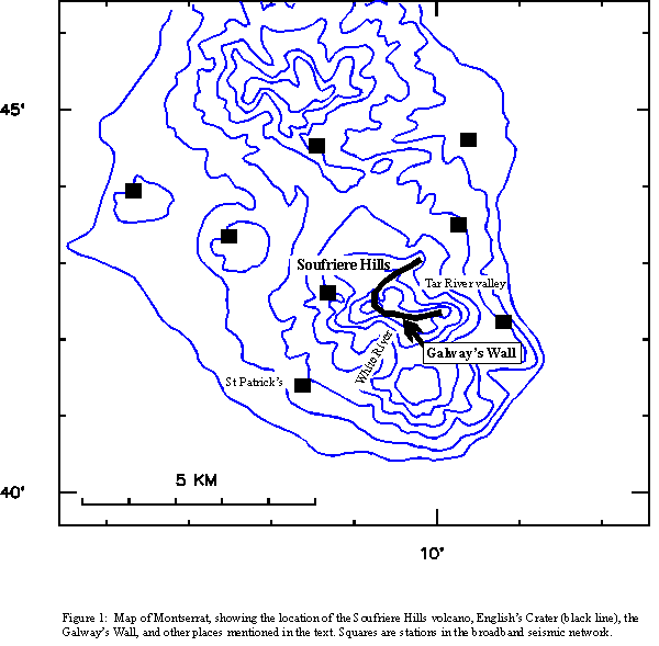
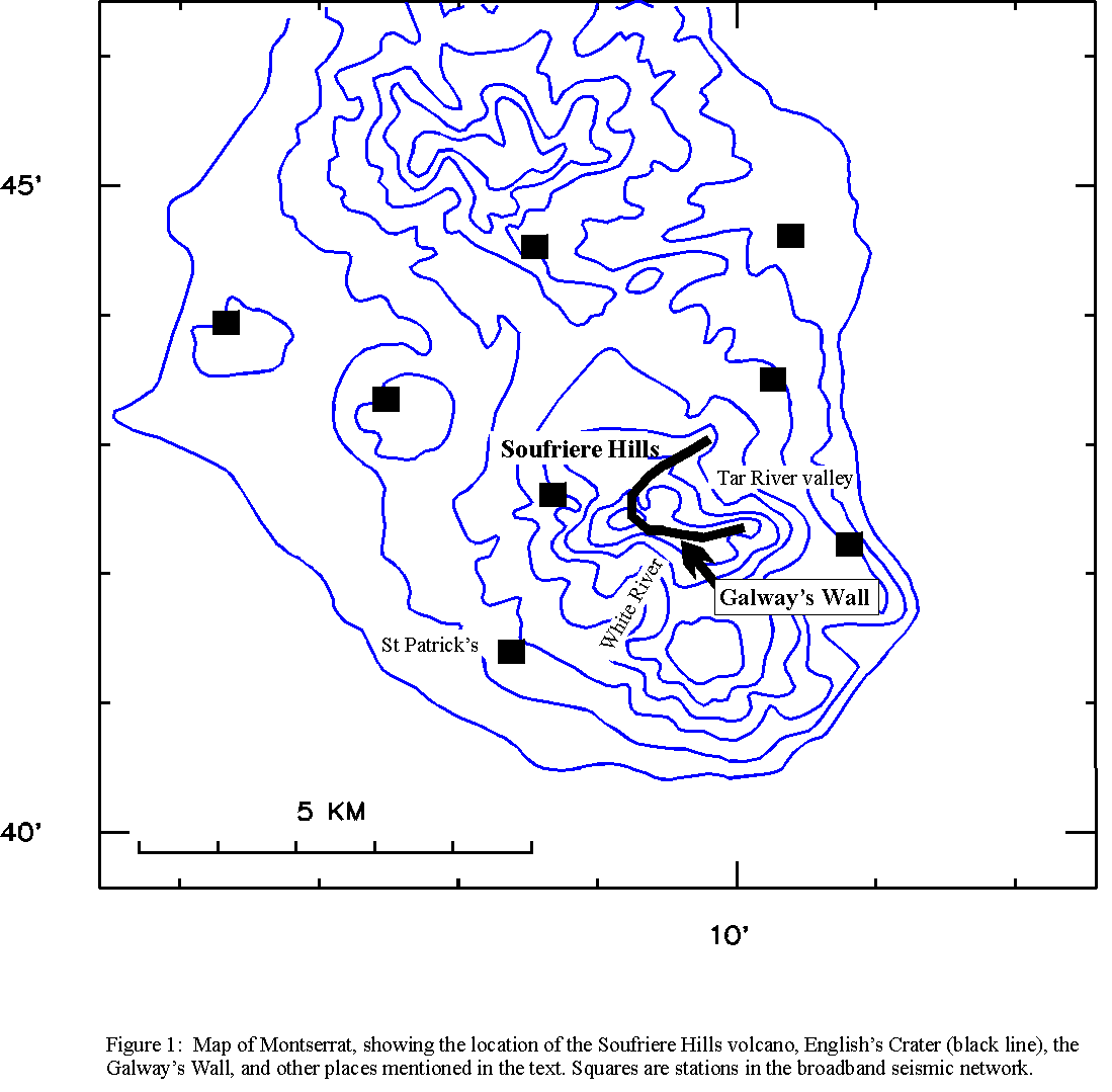
Figure 1. The location of the Soufriere Hills Volcano.


Special Report 02, Figure 2

Small GIF - Larger GIF - Postscript

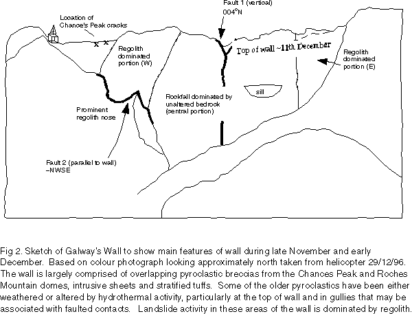
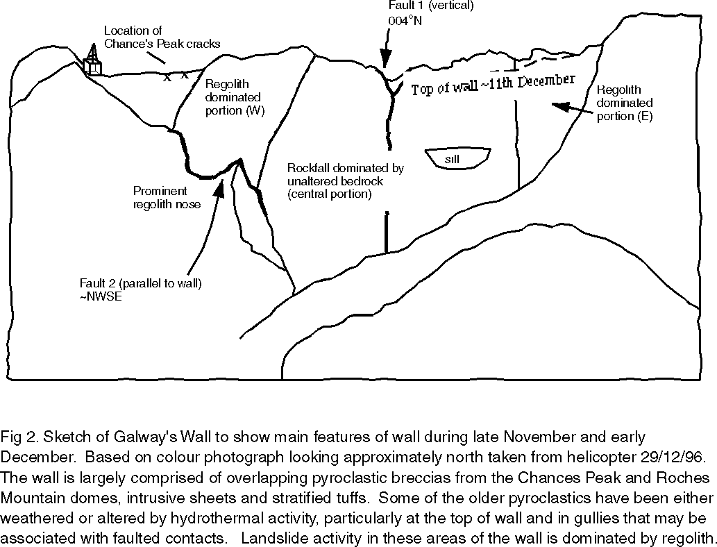
Figure 2. Sketch diagram of the main geological features of Galway's Wall.

Table 1: Chronology of deformation of the Galway's Wall, November-December 1996

Date Visual observations Seismic monitoring Dome volume survey Deformation
4/11/96 - Strong landslide signal (identified retrospectively) - -
6/11/96 Landslide debris observed - - -
26/11/96 large landslide - - -
26/11-10/12/96 Cessation of dome growth and rockfall activity Shallow earthquake activity Dome surveys 26/11, 1-3/12/96. Cessation of dome growth -
1/12/96 - - - Large cracks on Chances Peak
4-10/12/96 - - - Rapid opening of Chances Peak cracks
4-13/12/96 - - Uplift of pre-September dome -
10/12/96 - End of shallow earthquake swarms - -
11/12/96 - - - Decrease in the rate of crack opening
12/12/96 Cessation of Galway's landslide activity Cessation of Galway's landslide activity - -
11-19/12/96 Extrusion of December 11 dome - Dome surveys on 13 and 19/12/96 -
19/12/96 Collapse of December 11 dome and generation of pumiceous pyroclastic flows - - -


Degradation of the Galway's Wall

Evidence for large-scale landslides was first observed on 6 November, probably the result of landslides on 4 November that were retrospectively identified from the seismic record. Prior to this, some limited denudation of the wall through loss of regolith had been noted. Extensive avalanching of regolith material was noted around 23 November along with the re-activation of pre-exisiting fault planes (Table 1; Figure 2). There was a range of landslide types, from almost-continuous streams of loose debris derived from the more friable and weathered pyroclastic strata, to discrete avalanches of large, solid sections of the wall. Fractures in the wall were observed to develop and enlarge over periods of a few hours to days, eventually resulting in rock failure that produced some of the larger landslides. There was a clear relationship between earthquake activity and landslides, with several examples of landslides being triggered by strong shaking by earthquakes. In some cases ground shaking triggered several landslides simultaneously in different places across the wall.

On the morning of 26 November field teams observed a large landslide from the wall. From the strength of the seismic signal, this landslide was estimated to be smaller than the 4 November slide. This sudden slip involved about 100,000 cubic metres of material, excavating a large amount of unaltered bedrock for the first time and producing talus to a depth of 1.5 m at the base of the wall. Following this, there was a higher level of landslide activity, with the development of more fractures throughout the wall. Poor visibility hampered observation between 26 to 30 November. On 1 December two large cracks were observed on the south-eastern flank of Chance's Peak (Figure 2). These cracks were at least 35 cm wide at the surface and could be traced laterally for 100 m, and vertically through the wall, visible to at least 60 m deep. The trace of the cracks (020o to 030o) was approximately perpendicular to the crest of the Galway's Wall. Throughout early December these cracks continued to open and segment, as described in the deformation section below.

Landslide activity from the outside of Galway's Wall peaked around 6 and 7 December. Avalanching from the central portion of the wall comprised unaltered bedrock, whilst detritus from the western and eastern portions comprised mainly regolith and altered bedrock (Figure 2). This material had a maximum runout distance of about 600 m, and reached almost to the Galway's Soufriere. The fractures observed earlier propagated further down the wall and a network of new fractures were noted. Some of these fractures ran parallel to the wall, suggesting some outward bulging of the wall. When the top of the wall became visible again, on 10 December, about 20 to 30 m of material had been lost from the top as the result of continued attrition. An estimate of the volume of avalanched material in the talus slope at this time was 600,000 cubic metres.

Activity on the Galway's Wall decreased significantly after 13 December, with little new material added to the talus slope throughout the period of rapid dome growth between mid-December and late January. Re-activation of landslides occurred in late January, with rapid erosion of the top of the wall and the flank closest to Chance's Peak.

During heavy rains on 1-2 February, a prominent notch was cut through the low point on the wall and thereafter, cool and then hot dome material avalanched over the wall and gradual denudation of the remainder of the wall continued. Pyroclastic flow activity on 30 March rapidly excavated the notch into a well-defined chute, marking the effective end of the Galway's Wall as a retaining feature.

Dome Growth

During most of November, dome activity was largely confined to the northern and eastern sectors of the crater, with the "October 1" dome filling the scar caused by the explosive event of 17 September 1996. This period was characterised by a declining growth rate, from about 15,000 cubic metres per day at the beginning of the month to 5,000 cubic metres per day at the end. The level of rockfall activity, and thus probably the extrusion rate, varied over periods of a few days. The number of rockfalls was lowest during shallow earthquake swarms. After 26 November dome growth and rockfall activity essentially ceased, with dome growth between 26 November and 10 December confined to a region of endogenous growth in the southern portion of the October dome.

During clear conditions at the beginning of December a series of dome surveys was completed, and these were repeated on 13, 16 and 17 December. The later surveys showed that a significant area of uplift had occurred at the same time as the longest earthquake swarm (1-11 December). This zone of uplift was located in the area of the pre-September dome closest to the Galway's Wall (Figure 3). The maximum uplift was over 100 m and this attenuated rapidly to less than 20 m at 200 m from the focus. This uplift represents an additional 2.5 million cubic metres of dome material. Resurveying of similar points on 13, 16 and 17 December showed that the uplift had ceased by 13 December. The pre-September dome was locally incandescent and produced large volumes of steam and SO2 in the uplifted region throughout early December.


Special Report 02, Figure 3

Small GIF - Larger GIF - Postscript

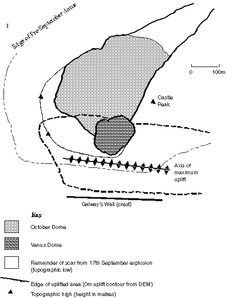
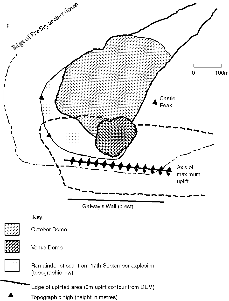
Figure 3. Map of English's Crater, showing areas of dome growth and uplift in November and December 1996.

On 13 December a new area of vigorous exogenous dome growth was observed in the south western portion of English's Crater, about 150 m north of the centre of endogenous dome growth. This new growth probably started two days earlier, coincident with the cessation of shallow earthquake swarm activity, and so was called the "December 11" dome. This dome filled the topographic low between the October 1 dome and the edge of the September explosion scar (Figure 3). The rate of dome growth was initially high (2.9 m3/s or 250,000 m3/day), with the dome gaining about 40 m in height between 13 and 15 December. Rockfalls occurred from the south and east flanks of the new dome (the other flanks of the dome were not visible at this time). After 16 December the growth rate slowed slightly, and the dome spread laterally rather than gaining height.

The eastern flank of the December 11 dome became increasingly unstable and over-steepened, with material overtopping the September explosion scar and avalanching into the upper Tar River valley from 16 December onwards. Although growth appeared to have slowed, the dome remained active with discrete pulses of rockfalls and small pyroclastic flows occurring throughout 17-19 December. The maximum runout distance of these flows was 1 km.

At 5:06 pm on 19 December, a period of major pyroclastic flow activity started. These pyroclastic flows appeared to be unusually mobile and occurred in several pulses of activity, with the furthest travelled reaching the delta at about 5:46 pm. Visual observations suggested that material was instantaneously spalling at the time of extrusion, indicating a relatively rapid ascent rate at that time. Drifting of cloud across the strongly incandescent dome gave the impression of fountaining at source. Flows and associated ash clouds were tracked down the Tar River valley by a FLIR (Forward Looking Infra Red) instrument, but changes in source temperatures could not be deduced. Later sampling of these deposits showed that the majority of juvenile material produced at this time was pumiceous with signs of shear stress in the fabric (stretched, shattered and vesiculated hornblendes). Part of the pre-September dome was also involved in these collapses, exposing incandescent material immediately below the surface.

Rockfall activity and growth essentially ceased on the December 11 dome following these collapses. Around 21 December rockfall activity switched to the northern and eastern portions of the October dome. Although small pyroclastic flows were observed, no new exogenous growth was visible until 26 December with the rapid extrusion of dark, rubbly lava, capping the NE sector of the October dome.

Dome growth through late December and much of January continued at a high rate (e.g., 6 m3/s in early January) and a large sector of the eastern flank of the dome was active throughout this period, showing strong incandescence even in daylight. Large collapses punctuated growth at this time, the most significant ones on 8, 13, 16 and 20 January. Dome growth slowed to about 2 m3/s in late January and through February, with talus material eventually reaching the top of the Galway's Wall on 29 January, after filling and overtopping the January 20 collapse scar.

The focus of dome growth switched back to the south, adjacent to the Galway's Wall, on 11 March, and the first major collapse of dome material over the Galway's Wall into the White River valley occurred on 30 March.

3. Seismicity

Monitoring Networks and Event Classification

The seismicity of the Soufriere Hills volcano has been monitored by a temporary network of 8 short-period instruments. Most of these instruments have only vertical components. In October 1996, a new network was installed, designed to be the permanent monitoring network for the volcano. The network consists of five broadband, three-component stations and three one-component, short-period stations. Throughout the period of this report, both networks were in operation, and data from both networks is described here.

Seismic events are classified in 5 main categories (Table 2; Figure 4). Using data from the short-period network, which has a low dynamic range, it is difficult to distinguish between hybrid and volcano-tectonic earthquakes, and many events were wrongly classified during this period, and reported in MVO daily and weekly reports. Data from the broadband network show that VT earthquakes are rare, with only occasional discrete earthquakes and one significant VT swarm on 2 November.


Special Report 02, Figure 4

GIF - Postscript

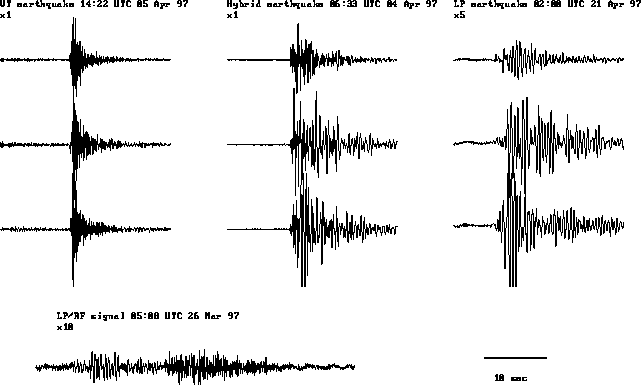
Figure 4. Example seismograms from the MVO broadband network.

Table 2: Seismic signals recorded at the Soufriere Hills Volcano

Type Description Frequency Typical duration
Volcano-tectonic earthquake Short, high-frequency signal with impulsive arrivals and clear P and S waves. Broadband, 3-10 Hz 10 to 150 s
Hybrid earthquake Short signal, usually with impulsive arrival. Initial high-frequency signal (especially at close stations) followed by lower-frequency coda. Non-existent S waves. 1-5 Hz, dominant ~2 Hz 10 to 150 s
Long-period earthquake Short, usually near-monochromatic signal with emergent arrival Strongly peaked spectra at 1-2 Hz, very little energy >2Hz. 10 to 60 s
Banded tremor Continuous signal, often composed of closely spaced, repetitive hybrid earthquakes 1-5 Hz, dominant ~2 Hz 0.5 to 2 hours
Dome rockfall Emergent signal, usually cigar-shaped Broadband 30 s to several minutes


The main earthquake class recorded during this period were hybrid earthquakes. More analysis of these events is underway, using data from the broadband network. The hybrids usually occurred in swarms, with irregular event spacing within each swarm. They have poorly developed P arrivals, with most of the energy on the horizontal components. The waveforms are complex from shortly after the initial P arrival. The azimuths of the first half-cycle at different stations (presumed to be the P arrival) have been calculated for a few earthquakes, and are consistent with a shallow source beneath the crater region. Standard hypocentre locations from the first arrival times give depths at around 2 km beneath the top of the dome, but the depths are very poorly constrained because of the network configuration and the lack of S arrivals.

Following positive correlation of a Galway's Wall landslide with a seismic signal on 26 November, it was possible to distinguish routinely between wall landslides and rockfalls/pyroclastic flows from the dome. The wall landslides had higher amplitudes at stations in the south (St Patrick's and Galway's Estate) relative to stations in the east (Long Ground and Bethel). October to 11 December 1996 - shallow earthquake swarms and deformation of the Galway's Wall

This period was characterised by swarms of hybrid earthquakes, located at shallow depths beneath the crater. Shallow swarm activity began on 21 October. In the 8 days before then, there was diffuse VT activity at depths down to 4 km, located slightly north of the crater. From 21 October until 20 November, there were 11 swarms which lasted between 5 hours and 3 days, with the time intervals between the swarms varying from 20 hours to 2 days. The swarm characteristics changed with the swarm on 1-2 November (Figure 5). Before then, swarms were small, of short duration and with short intervals between them; both less than one day. After 1 November, the swarms had many more events, were much longer and had longer inter-swarm intervals.


Special Report 02, Figure 5

Small GIF - Larger GIF - Postscript

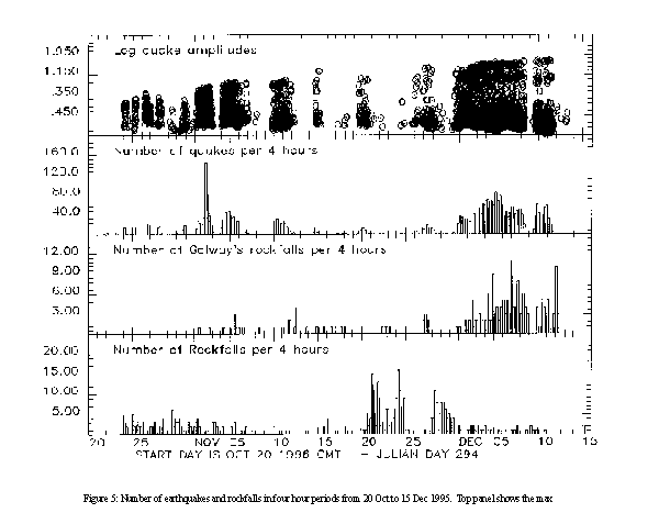
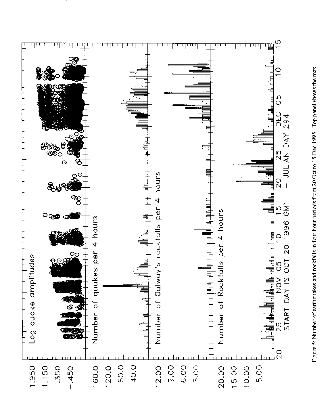
Figure 5. Number of earthquakes recorded by the broad-band network in 4-hour periods. Top panel shows the maximum amplitude of earthquakes, averaged from the vertical components of all broadband network stations.

With the exception of a short period on 2 November, all the earthquakes in these swarms were hybrids, and mostly located at shallow depths (0-2 km) beneath the crater. Throughout the swarm activity, there was no detectable migration of the locations in either depth or horizontal position. The swarm on 1-2 November was the only swarm which had VT earthquakes, and those mostly had hypocentres deeper than 3 km. The swarm was, at first, similar in intensity to the previous swarms, with up to ten hybrid earthquakes per hour. Deeper VT activity started almost 24 hours later at 00:06 on 2 November. This only lasted about four hours, but was very intense, with up to 38 earthquakes per hour. The depths of these events were mainly between 2 and 4 km and the signals showed clear S phases. Almost immediately after the VT activity there was an increase in the intensity of the shallow hybrid activity, with the rate increasing to up to 20 per hour.

The magnitudes of these swarm earthquakes have not been calculated. Instead, an estimate of the event size has been obtained from the maximum amplitude (averaged over a 2-second moving window), for the vertical component of all the broadband stations in the network (Figure 5). This can be assumed to be related to the magnitude if the earthquake hypocentres are in approximately the same place, and if there is no variation in radiation pattern. The plot of amplitudes shows that the size of the largest events increased slowly through November and early December. During early December, some of the earthquakes were felt strongly by MVO staff on Chance's Peak and at the Galway's observation post. A few larger events were reported as felt by residents of Weekes, on the western side St George's Hill. The amplitudes are plotted on a logarithmic scale in Figure 5, which is equivalent to plotting magnitudes. It is clear that there is a bi-modal pattern to the magnitudes, with small earthquakes dominating and few earthquakes of intermediate size. The largest earthquakes were estimated to have a magnitude of 3.5.

An analysis of rockfall signals recorded on the broadband network showed that cold landslides from the outside of Galway's Wall occurred since at least 24 October. The largest of these by far occurred on 4 November, and probably resulted in the debris that was noted on 6 November during a helicopter observation flight. The most intense Galway's landslide activity was during the earthquake swarm between 30 November and 11 December (Figure 5). Many of the observed landslides in this period were triggered by shaking by hybrid earthquakes.

Rockfall activity from the dome was at a low level during October and early November, as the area of active dome growth was contained within the September explosion scar. A period of significant rockfall activity started on 21 November. This activity peaked in the early morning of 24 November, with the highest amount of rockfall activity since the start of growth of the October 1 dome. Rockfall activity declined after that and had returned to a low level by 26 November. Another period of rockfalls lasted from 27 to 30 November.

There was a strong inverse correlation between dome rockfalls and the shallow swarm activity between October and mid-December (Figure 5). The periods of highest rockfall activity in late November occurred during gaps between hybrid swarms. Dome rockfalls were not completely absent during the swarms, but many of these rare dome rockfalls were caused by shaking of the dome surface by the larger hybrid earthquakes. 11 December 1996 to March 1997 - rapid dome growth

Following the abrupt end of the longest hybrid swarm on 11 December, the seismicity was at a much lower level, with occasional long-period earthquakes and rockfalls from the growing December 11 dome (Figure 6). The number of rockfall signals gradually increased up until the dome collapse in the evening of 19 December.


Special Report 02, Figure 6

Small GIF - Larger GIF - Postscript

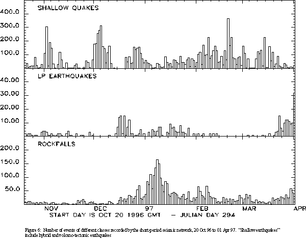
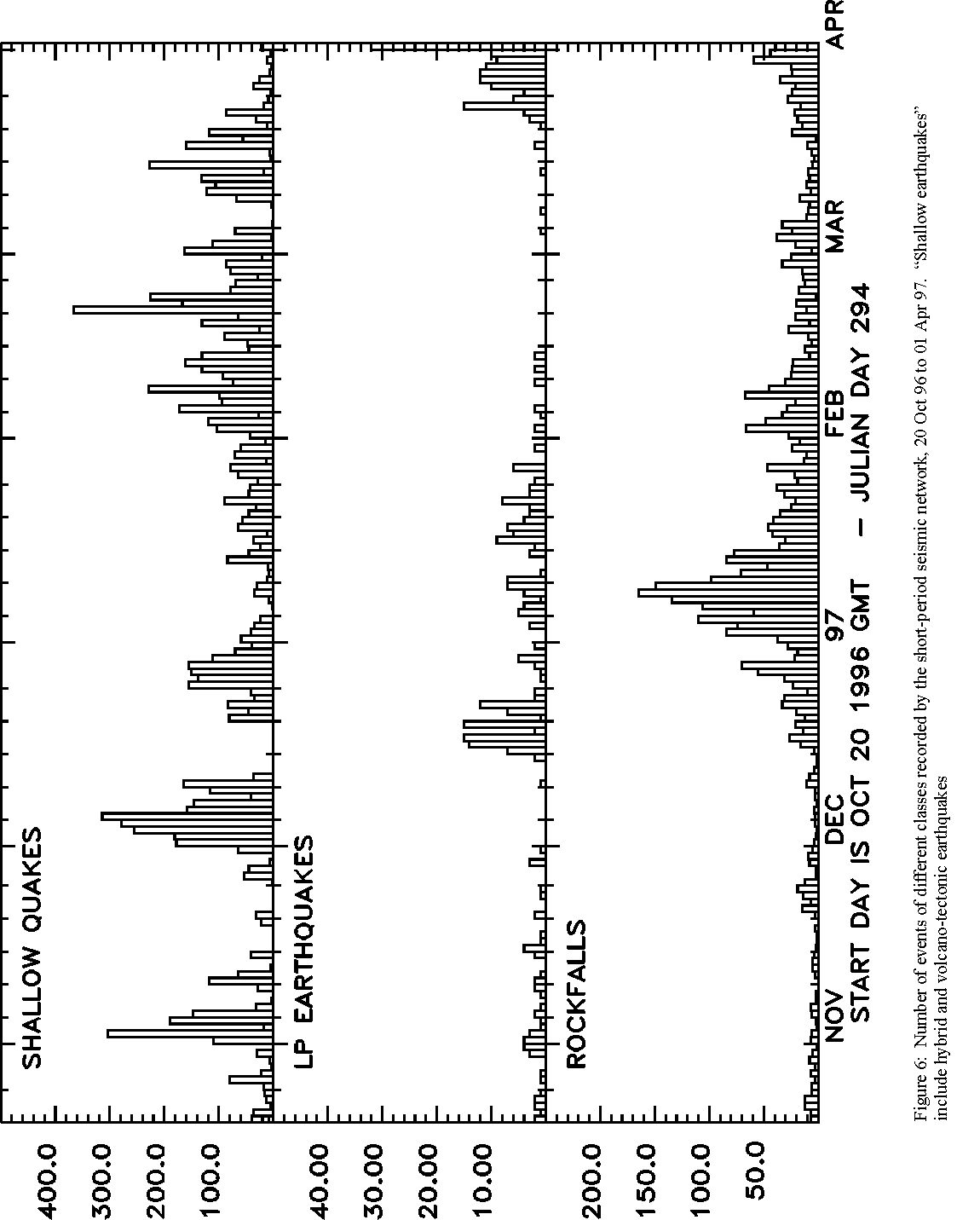
Figure 6. Number of earthquakes and rockfalls recorded by the short-period network, October 1996 to April 1997.

Extrusion of a new lobe on top of the October dome at the end of December was accompanied by repetitive hybrid seismicity and volcanic tremor. The level of rockfall activity gradually increased as the new extrusion became more unstable, and there were several dome collapses during January 1997. Shallow hybrid swarm activity restarted on 13 January, at about the same time as the deformation rate of the Chances Peak cracks began to increase (see Deformation section). Many of the swarms of hybrid earthquakes in February graded into repetitive hybrids and periods of tremor, lasting for about 1 hour. Although the rate of occurrence of non-repetitive hybrids did not reach the levels seen in November and early December, the magnitudes of the largest earthquakes gradually increased, and by late January exceeded the maximum magnitudes recorded in December. The number and intensity of the earthquake swarms gradually diminished during early March.

From mid-March, the number of long-period earthquakes and rockfalls increased, accompanied by dome growth in the south of the crater.

4. Deformation

The methods of deformation monitoring already in place at the Soufriere Hills volcano, which comprised GPS and EDM surveys of the east, north and west flanks, were unable to provide quantitative information relevant to the wall deformation during November and December. The observation of new cracks on Chance's Peak led to a crack-monitoring program and the deployment of more instrumentation, including a tiltmeter and a real-time crack extensometer.

Mapping of fracture development on the Galway's Wall itself proved impossible due to the rapidity of the changes between 26 November and 11 December. Regular shedding of material revealed new surfaces, and only the major fracture features survived this continual degradation. The major, near-vertical, wall-perpendicular fractures in the wall showed opening in the narrow upper part of the wall, and were often the focus of the small-scale landslide activity, probably due to the less resistant weathered material associated with the fault plane. Some or all of these faults could be crater-wide faults, and at least one showed a thin fault breccia within it. No major displacements across these features were seen. In addition to vertical cracks normal to the wall, many wall-parallel fractures developed as peels from the wall. No water seepage was noted at any of the Galway's Wall fractures, indicating a lack of groundwater within the wall itself.

A landslip occurred in the Galway's Soufriere area in late November. The central part of the soufriere region slipped down about 1.5 to 2 m along an arcuate slip plane adjacent to the steep slopes above the soufriere. However, the Soufriere area has shown signs of instability throughout the current volcanic crisis, and it is unclear whether or not the strain exerted on the Galway's Wall resulted in additional deformation in the soufriere area, almost a kilometre away. New monitoring equipment was installed on Chance's Peak to measure the deformation close to the wall after through-going cracks were observed around the Chance's Peak area in early December. Real-time information came from a high-gain tiltmeter (installed 9 December) in the Cable and Wireless hut on Chance's Peak and from a low-gain tiltmeter and an extensometer located at Crack 2 (installed 21 December), the western of the two main cracks from the Galway's Wall. Frequent manual measurements were made of distances between fixed points across both Cracks 1 and 2 from 4 December and provided additional information during the peak of activity and after loss of the electronic instruments at the end of February (Table 3; Figure 7).

Table 3: Movements on Cracks 1 and 2 near Chance's Peak.

Units are cm and cm/day

		Crack 1 - Opening	Crack 1 - Shear
Date 		Displacement	Rate	Displacement	Rate
9 December 	33.3		6.66	7.4		1.48
10 December	4		4.00	1.1		1.10
15 December	2.9		0.58	11.5		2.30
21 December	1.2		0.20	-9.6		-1.60
31 December	1.3		0.13	0.9		0.09
12 January	2.9		0.24	1.1		0.09
22 January	7		0.70	3.1		0.31
26 January	6.5		1.63	3		0.75
28 January	4.1		2.05	1.4		0.70
11 February	45.7		3.28	23.9		1.71

		Crack 2 - Opening	Crack 2 - Shear
Date		Displacement	Rate	Displacement	Rate
9 December 	0.9		0.18	-0.3		-0.06
10 December	0.4		0.40	-0.6		-0.60
15 December	0.9		0.18	-7.3		-1.46
21 December	0.3		0.05	9.6		1.60
31 December	0.9		0.09	8.3		-0.13
12 January	1.1		0.09	0.4		0.03


Special Report 02, Figure 7

Small GIF - Larger GIF - Postscript

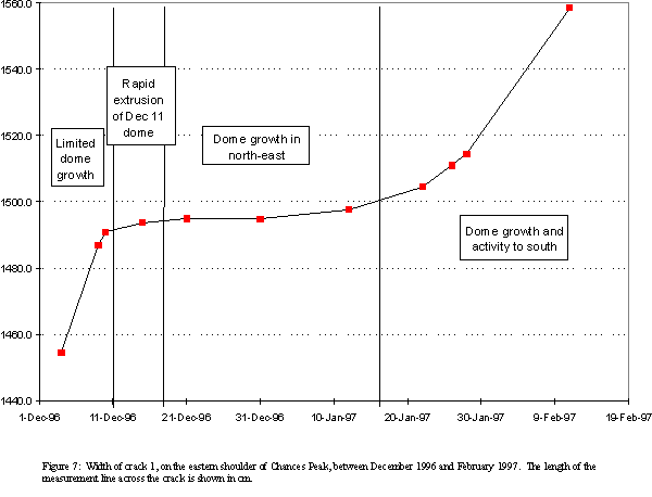
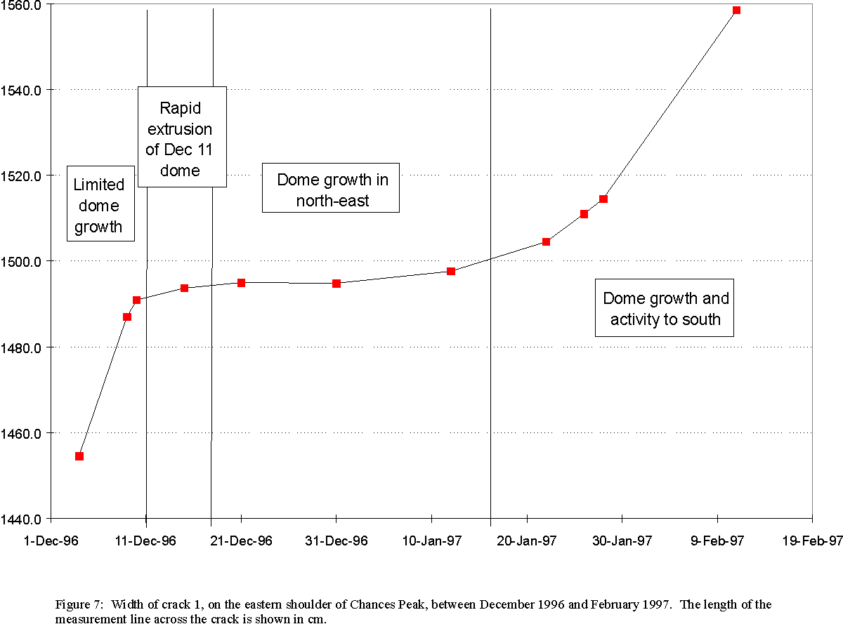
Figure 7. Distance across crack 1 on Chances Peak.

Crack 1, which showed the higher rate of deformation of the two measured cracks, showed rapid opening and right-lateral shear between measurements made on the 4, 9 and 10 December (Figure 7). The rates of crack deformation prior to 4 December is unknown, but it is thought that the rapid rate of crack movement was probably sustained between 1 and 10 December. Opening on Crack 2 at this time was an order of magnitude less. No shear was measured on Crack 2.

Between mid-December and mid-January, crack deformation dropped markedly, but increased again following the collapse of the dome on 20 January. Crack 2 showed increased shear and crack fragmentation, with a switch from normal to shear tension occurring in mid-February. Rate of shear was constant at about 3 mm/day from this time until the end-March dome collapse. The extensometer showed minor opening events coincident with hybrid earthquake swarms during mid-February (MVO Scientific Report 54). Crack 1 showed a rapid acceleration in shear and opening from 20 January to 14 February, after which no more measurements were possible due to the encroaching backwall of landslides from the Galway's Wall. Total opening of more than a metre occurred on Crack 1 during the 10 weeks of measurements.

Tiltmeters provided information on two processes related to deformation in the Chance's Peak area. A vector set from the high-gain tiltmeter on the northern side of Crack 2 and the low-gain tiltmeter on the south side of Crack 2 suggested small-scale tilt (few tens of microradians in 30 days) in opposite directions across the crack, with azimuths of 105 (on the north side) and 285 degrees. A second vector set from the high-gain tiltmeter occurred in a cyclic nature, with a periodicity of 6-8 hours and with opposite direction radial to the dome. This periodicity showed a strong correlation with RSAM peaks, especially in late December and early January, and is thought to indicate pulsatory dome growth and/or pressurisation during this period.

The short occupation GPS equipment was used to occupy each of the wide-area networks twice during the peak of activity. The occupations revealed no significant deformation across the volcanic edifice at this time. EDM measurements on the northern and western networks showed a similar lack of deformation. EDM measurements to more proximal reflectors on Chance's and Castle peaks showed higher rates of deformation, although neither showed marked changes in rate during the period of the peak of activity. Outward movement of the Chance's Peak reflector totaled 2.7 cm between 19 October and 2 December. Thereafter the reflector was covered by ash and difficult atmospheric conditions prevented measurements being taken routinely. The same problems prevented the use of temporary reflectors installed on 4 December at the top of the Galway's Wall itself.

Movement of the Castle Peak reflector actually slowed during the largest seismic swarm, with a rate of line length shortening between Castle Peak and White's Yard of 0.5 cm/day between 23 October and 20 December compared with a rate of c. 0.7 cm/day for the period before that. A rate of 3 cm/day was recorded immediately prior to the renewal of exogenous growth on the NE area of the dome on the 26 December. Short term increases of deformation rate prior to major increases in extrusion rate have been observed before in mid-November 1995 and late July 1996.

Gravity measurements were made in July and December 1996 along a network which consists of four radial lines in the Whites, Farrells, Amersham and Chances Peak areas with intermittent stations dispersed between these traverses. Figure 8 shows height and gravity changes along a profile from Brodericks to Chances Peak. Gravity measurements and height changes of all field stations are relative to a base station at DOS mark M24A situated at Plymouth Clock Tower. Errors on gravity measurements are +/- 10microGals whilst errors on the elevations of stations are to within 8cm as triangulation of points is not made. The data indicate overall inflation, although elevation changes seen in the six-month period are small, this is associated with a slight gravity decrease. The gravity decrease could be explained by decreasing density and / or mass of source, but again changes are small. The results, coupled with gravity measurements at Galway's Estate and Galway's Soufriere, indicate that in the six month period between June and December 1996, no large sub-surface intrusion has occurred directly under Galway's Wall, as all stations in figure 8 would show a grater gravity increase. Therefore the changes occurring to Galway's Wall must be a result of near-surface processes (i.e. above or at the base of the dome).


Special Report 02, Figure 8

GIF - Postscript

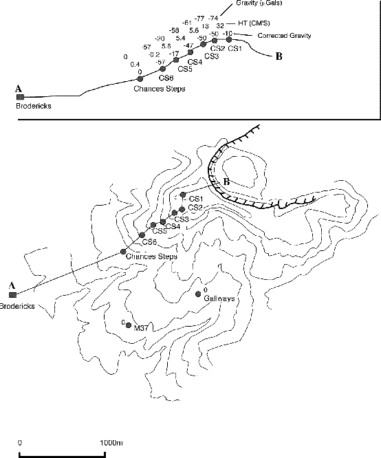
Figure 8: Plan and cross section of the Chances Peak radial micro-gravity line. Once relative gravity observed between July and December 1996 is corrected for elevation changes observed over the same time period, the corrected microgravity changes are very small. Given that errors are +/- 10microGals the overall changes are no greater than 40microGals.

5. Volcanic Hazard and Alert Levels

The hazards presented by the activity associated with deformation of the Galway's Wall meant that much of the pre-existing alert-level criteria, based largely on continued dome growth and collapse into the Tar River Valley, had to be re-assessed as the situation progressed. The changes in alert level and the hazard map are summarised in Table 4.


Table 4: Summary and Chronology of Changes in Hazard Assessment.

Date Change in Hazard Map / Alert Level Main activity Earlier record of similar activity
1 November Amber ->Orange Intense earthquake swarm late July 1996
September 1996
19 November Orange ->Amber decrease in intensity of swarms activity as at Oct 1996
26 November St. Patrick's and surrounding area rezoned to A landslide activity from Galway's wall heightened swarm activity unprecedented
28 November Amber->Orange heightened landslide activity, building seismic activity unprecedented
3rd December closure of zones A to D intensifying swarm coupled with increasing landslide activity and opening of cracks near Chance's Peak unprecedented
5 December Temporary risk map; Zones A to D became Zone A/B as above as above
19 December Orange -> Red Alert Continuous dome collapse, fed by new material July-September 1996 with variations
21 December Red-> Orange Alert Activity at lower level as above
late January removal of temporary risk map landslide activity on Galway’s Wall ceased, low level of seismic activity activity at same level as mid-November
17 February Orange ->Amber chances of major dome collapse subsided activity at same level as October


A high level of concern was expressed about the stability of the Galway's Wall at a scientific meeting on 25 November, following visual observations made from the helicopter between 23 and 25 November. A new risk map was issued on 26 November to account for the possibility of a sudden collapse of the Galway's Wall causing a lateral blast to the south. The St Patrick's area was moved to Zone A and the area between Gingoes and Aymer's ghauts redefined as Zone B.

After a sizeable landslide from the Galway's Wall occurred on 26 November, scientific teams withdrew from the area between St Patrick's and Galway's, and later field visits to this area were made only by helicopter. The landslide also provided the final incentive to encourage almost all of the remaining population within the new Zones A and B to leave. The increased instability of the Galway's Wall prompted the increase from amber to orange alert on 28 November.

At this point the consensus interpretation was that the Galway's Wall landslide activity was probably not simply due to erosion, and that an intrusion behind the wall was deforming the wall, resulting in the formation of cracks throughout the wall. Hazard assessments were based on the possibility of there being fresh, pressurised magma immediately behind the wall, so that a lateral blast might occur if the wall failed catastrophically.

The most likely scenario envisaged by MVO scientists was that the wall would gradually crumble, with the possibility of dome material forming pyroclastic flows if the top of the wall was lowered substantially. The rapid rate of opening of the cracks on Chance's Peak, combined with the intensifying seismic swarm and increasing Galway's landslide activity led to fears that the situation was approaching a climax, with an enhanced probability of a lateral blast which might develop into a sustained vertical eruption, putting Plymouth and environs at risk from pyroclastic flows, ash cloud surge and aerial fallout. This worst-case assessment resulted in the recommendation for a complete closure of zones A to D on 3 December. A temporary revision of the risk map was published on 5 December, which formalised this recommendation.

The possibility of an wholesale collapse of the wall resulting in material reaching the sea and generating a tsunami was considered. Initial information concerning this newly-identified hazard was given by the authorities on Montserrat to CDERA on the advice of MVO on 30 November. Scientists from IPGP in France, in conjunction with MVO, were able to provide rapid initial estimates of the tsunami threat, and this was followed by more detailed analysis by a team of visiting scientists from BRGM and IPGP, based on data provided by MVO.

Major pyroclastic flows on 19 December, caused by the collapse of the December 11 dome, prompted an increase in the alert status to red. There was a reduction to orange alert after 36 hours when the level of activity returned to normal levels.

The temporary revision to the risk map was lifted on the recommendation of MVO in late January, and this was followed by a reduction in alert level from orange to amber on 17 February.

6. Discussion

The deformation of the Galway's Wall and the subsequent erosion and pyroclastic flow production represents one of the most restless phases during the current eruption of the Soufriere Hills Volcano. Intense seismic activity was recorded, there was rapid switching in the location and style of dome growth, and the wall deformed visibly with large fractures forming across the crater rim and landslide activity from the outside face of the wall.

The main feature of the seismicity of this period was the sometimes intense swarms of hybrid earthquakes, which are thought to be due to a shallow magma-related process, probably beneath the dome. Preliminary studies show that there is sometimes high correlation of waveforms between different earthquakes, indicating a repetitive source. The hybrid earthquakes probably occur when magma pressure in the upper conduit increases. The correlation between the Galway's Wall landslides and the swarms suggests that somehow the stress on the wall was increased during the swarms, although ground shaking by the earthquakes is also thought to have played a part in increasing the landslide activity.

This is consistent with the intrusion of a body of magma at the base of the dome. The pre-September dome responded in a plastic manner, because most of the dome in this area was extruded only 6 months earlier in June 1996 and the high temperature of the dome material prevented a brittle response. The cold Galway's Wall, however, was stressed and fractured by the extension associated with the intrusion.

Dome surveys showed that the intrusion and uplift had halted by 13 December, consistent with the cessation of earthquake swarms and landslide activity from the Galway's Wall. A general slowing of the extension and shearing of the cracks on Chance's Peak suggested a lessening of the stress on the crater wall, and this accompanied rapid dome growth. Enhanced incandescence and levels of SO2 degassing from the pre-September dome adjacent to the Galway's Wall at this time indicated that a fresh, hot magma body was close to the surface. During the collapses of 19 December, tapping of this hot material produced pumiceous pyroclastic flows, prompted by collapse of the December 11 dome. The rapid ascent of this material resulted in rapid exsolution of volatiles and consequent expansion of the magma immediately prior to eruption. The relatively short ascent path to the surface of the material may have prevented initiation of a vertical eruption column at this time.

Following collapse of the December 11 dome, growth switched to the eastern and central parts of the dome and rate of extrusion increased significantly. It is not clear what prompted the switch in growth activity on the dome, but the central focus was sustained throughout the period of rapid growth until late-January and it is likely that a different part of the upper feeder system was being utilised at this time. A switch back to growth in the south in mid-March preceded by increased hybrid earthquake activity and crack deformation appears to represent a repeat of the pattern of November and early December.

The activity at the Galway's Wall shows that the confining crater walls are vulnerable to intrusive activity, which can cause deformation and collapse and allow pyroclastic flows to exploit new routes from the crater. During this period, there were several rapid switches in the locus and style of dome extrusion, and this seems to be a characteristic of the current eruption. In this instance, the wall deformation and eventual erosion proceeded in slow and predictable stages. However, it is a cause for concern that the northern and western crater walls could be affected in similar ways, and any pyroclastic flows in these directions would have far greater human impact.

List of Tables

List of Figures The figures are available in a small image format (usually 600x400 GIF), a large image format (usually 1200x800 GIF), and Postscript


Montserrat Volcano Observatory