MVO LOGO

Montserrat Volcano Observatory, Montserrat, West Indies


Special Report 01
Report Of The Explosive Event Of September 17-18, 1996

W. J. McGuire, G. E. Norton, R. S. J. Sparks, R. Robertson and S.R. Young (with a contribution from A. D. Miller)

    Abstract
  1. Introduction
  2. Precursive Activity
  3. The Explosion and Related Events of 17-18.9.96
  4. Post-eruption Observations
  5. Constraining the Eruptive Mechanism
  6. Implications for Future Activity
    List of Figures

Abstract

By the morning of 17.9.96, the dome complex in English's Crater (Soufriere Hills volcano) had reached its largest volume (27-28 x 106 m3) since growth began late in 1995. Between 11.30 and 20.30 on the 17.9.96, semi-continuous pyroclastic flow production into the Tar River valley progressively unroofed the eastern flank of the dome. Following a period of reduced activity which lasted until 23.42, explosive dome collapse was initiated, triggered by further mass removal associated with possible pyroclastic flow formation between 23.42 and 23.53. From 23.53 to 00.00 there was at least one directed explosion, probably linked to unroofing of the conduit feeding the dome complex, followed by further pyroclastic flows and an eruption column which deposited pumiceous tephra over much of the southern half of Montserrat. Post-eruption observations suggest that between 20 and 30 % of the dome volume was removed during the eruption. Variations in the numbers of volcano-tectonic earthquakes in the run-up to the eruption suggest a link with Earth tides, and a combination of a large, unstable dome and high tidal stresses must be regarded as providing the optimum conditions for future dome collapse. Surface deformation associated with dome growth prior to 17-18.9.96 indicates that significant deformation is confined to the dome and its immediate surroundings, with only minor changes observed at distances of a few kilometres from the dome. The pattern of pumice and lithic clast sizes has been used to estimate the height of the eruption column. This proves to be around 14 km, a figure in agreement with the reported aircraft encounter with the ash plume at 10 km. The events of 17-18.9.96 have provided invaluable data for better constraining the nature of future activity. Most importantly, it is now clear that dome collapse can involve the significant explosive ejection of debris, and that a similar event in the future is likely. Account of this has been taken, in the preparation of a new series of hazard and risk microzonation maps, and in a reassessment of the alert level.

1. Introduction

In this report, information is summarised about the activity of the Soufriere Hills volcano, Montserrat, prior to an explosive eruption on 17-18.9.96. The precursive activity is assessed and the events of the night 17-18.9.96 are described. The deposits from this phase of activity are then detailed and an attempt is made to constrain the eruptive mechanism. The information presented in this report has already proved invaluable for the recent re-assessment of hazard microzonation and alert levels on the island and, it is hoped, has provided some predictive indicators for the recurrence of this type of event in the future.

2. Precursive Activity

2.1. Observations

Following the first extrusion of juvenile material between 14.11.95 and 16.11.95, activity at the Soufriere Hills volcano has involved the construction of an endogenous lava dome complex within English's Crater to the north-west of the old Castle Peak dome. Periodic collapse of the unstable new dome complex led to rockfalls and the generation of pyroclastic flows (PFs), the latter resulting in the progressive filling of the Tar River valley, which drains the breached eastern side of English's Crater, and the growth of a delta at the valley mouth. The dates of the main PF events are as follows: 27.3.96, 30.3.96, 1-2.4.96, 5-8.4.96, 12.4.96, 21.4.96, 26.4.96, 28.4.96, 11-12.5.96, 15.5.96, 20.5.96, 31.5.96, 1.6.96, 13.6.96, 16.6.96, 29.7.96, 31.7.96, 11.8.96, 21.8.96, 2-3.9.96, 17.9.96. Until 17.9.96, PF production had been non-explosive, and driven purely by gravitational collapse of oversteepened dome flanks. Both the average and maximum lengths of PFs has progressively increased, and on 12.5.96 flows reached the sea for the first time.

Since the end of March 1996, and prior to the events of 17.9.96, instability of the growing dome has triggered four significant dome collapses on the 29 - 31.7.96, 11.8.96, 21.8.96, and 2.9.96. The estimated dome volume at 17.7.96 was 25 x 106 m3, with an estimated 4.2 x 10⁶ m3 of dome-collapse derived material deposited in the Tar River valley. The most recent (27.8.96) estimate of the dome volume, prior to the 17-18.9.96 collapse, was 27-28 x 106 m3, the largest since dome growth began.

After the episode of dome collapse and PF production on 2.9.96, rock falls and PFs continued to be generated, although at a relatively lower level. Few PFs were produced over the period 7.9.96-15.9.96, over which time the seismic record was dominated by shallow (<2 km depth) volcano-tectonic (VT) earthquakes and rockfalls, probably associated, respectively, with the entry of fresh magma into the high-level magma system and dome growth. On 15.9.96, vigorous steam and ash venting was noted at the dome and small PFs were generated. Activity reached a higher level on 16.9.96, with the near-continuous generation of rock falls and/or PFs during the middle of the day. The activity increased further on 17.9.96 with rock-fall formation near-continuous at times, and a phase of dome collapse and large pyroclastic flow formation which began at 11.30. Significant ashfall affected Richmond Hill, Plymouth and its environs from this time probably until the early hours of the following morning. The level of PF activity dropped between 20.30 and 23.42, after which time the eruption entered the explosive phase (see section 3). 2.2 Seismic activity

The earthquake activity leading up to the events of 17.9.96 showed a marked increase in all types of seismic signals for a period of approximately 6 months, over which time the activity consisted of a cyclical series of dome building and subsequent collapse episodes. The seismic signals show marked variation in their rate of occurrence throughout this period. Variations in four types of seismic signal (rockfalls; volcano-tectonic: VT; long period: LP; and hybrid) are considered here, firstly over the time period since 1.10.95 and then in the 2 months preceding 17.9.96. The results presented here are based on near real-time classifications by a number of different, and variously-experienced operators. Thus the detailed patterns of earthquake distributions should be considered as being preliminary.

Rockfall signals were first recorded by the network on 16.1.96. There was then a gradual increase in the number of rockfalls per day to the onset of the PF activity on 27.3.96. The number of rockfalls was intimately associated with the PF events, with a gradual increase before PF activity and a sharper decrease after the activity. PFs were generated by successive collapses of the dome at 10-14 day intervals from 29.7.96 to 17.9.96. Each episode of dome collapse was preceded by an increase in rockfall signals and then succeeded by a gradual decrease in the number of rockfall signals. The maximum number of rockfalls in this later time period was observed on 20.8.96 when 157 rockfalls were recorded.

The number of rockfall signals is clearly associated with the collapse of the dome and formation of PFs, since all these phenomena are generated primarily by instability of the dome. The 10-14 day periodicity of the dome collapse during this period is probably a function of the extrusion rate. There is a possibility that this periodicity is related to tidal influence, but it is not exactly in phase with the tidal cycle, suggesting some as yet undetermined time-lag in the response of the system to tidal stresses.

VT earthquakes show a very interesting pattern. From 1.10.95 to 11.11.95, there were high numbers of VTs with a mean rate of 30 per day and a maximum count of 94 on 18.10.95. There were then very few VT earthquakes (maximum 5 per day) until 20.7.96. Between 0 and 88 per day were noted from 20.7.96 to 5.9.96 with a daily mean of 30. An further increase in the number of VTs per day was then seen, with a maximum of 211 per day on 11.9.96, before a gradual decrease to only 33 on 17.9.96.

In the four weeks immediately leading up to the activity of 17.9.96, a number of VT swarms were experienced. From 15.8.96 to 4.9.96, their occurrence was sporadic and had no apparent trend. After 4.9.96, however, the swarms occurred at between 400 to 1000 min intervals with a median interval of 684 min, and the time interval between swarms decreased over this time, particularly in the 2 days before the explosion (FIGURE. 1). The duration of the VT swarms is extremely variable, but between 12.9.96 and 17.9.96, the duration of these swarms was consistently below 150 min. The mean periodicity (approx 11.5 hours) of these swarms suggests that there may be a tidal influence on their generation. The highest tide in the previous two months was on 28.8.96 which corresponds to the onset of the enhanced VT activity. The next highest tide was on 12.9.96, which corresponds to the maximum number of VTs prior to this period of activity. This broad relationship to the tidal cycle may represent a useful predictive tool in the future, and the coincidence of high tidal stresses and a large, unstable dome may provide ideal conditions for future eruptions.

The daily number of long period (LP) earthquakes has been low and did not show any consistent pattern between 1.10.95 and 20.7.96. In the two months prior to 17.9.96, however, there were two distinct peaks in the number of LPs counted: on 22.7.96 (40 per day) and on 12.9.96 (43 per day). In the intervening period there was a lull in the number of LPs with generally no more than 15 per day. In this later period, this pattern follows that of the VT counts per day, and is probably related to shallow movement of magma.

The number of hybrid earthquakes varies considerably throughout the period since 1.10.95. Hybrid events tend to occur in repetitive swarms, often at a rate of one or more per minute with a regular repeat rate. These swarms often lasted for several days, and occurred in September 1995, November to December 1995, January 1996 and April to May 1996. The most significant numbers were observed in the period from 10.4.96 to 3.5.96 when up to 1128 (15.4.96) were counted. These partly coincide with the first dome collapse and PF generation episode. There is a second peak in hybrid counts between 30.7.96 and 14.8.96 with a maximum of 178 counts per day on 31.7.96, but then this count decreases to less than 40 per day for the remainder of the period up to the explosive episode.

2.3 Surface deformation

Four Electronic Distance Measurement (EDM) networks, and a number of independent baselines, were occupied during the period leading up to the events of 17-18.9.96, one of which (White's - Long Ground - Castle Peak) was unusable directly following the eruption and the loss of the Castle Peak reflector. This reflector was replaced on 2.10.96 by SY and BD. Prior to this, the Long Ground - Castle Peak baseline had shown a pattern of progressive shortening characterised by two distinct trends (FIGURE 2): a linear shortening of about 1mm per day between early January 1996 and June 1996, and a period of accelerating shortening until 11.9.96, the last time the network was measured. Between the end of August and 11.9.96, the baseline length reduction was of the order of 1 cm/day. Comparable accelerating trends were also shown by EDM baselines from White's to Castle Peak and Tar River to Castle Peak. The other networks showed smaller changes or none at all during late August and the first part of September. The O'Garra's - Galway's - Chance's Peak network confirmed the pattern of shortening along two baselines (Galway's - Chance's Peak and O'Garra's - Chance's Peak) broadly radial to the growing dome, as did radial baselines from Amersham to Gages and Dagenham to Gages. The rate of movement was, however, an order of magnitude smaller than that observed on the Long Ground - Castle Peak line, with a 17 mm shortening over the 20 days up to 13.9.96 of the Galway's - Chances Peak baseline. At the Windy Hill - St. George's Hill - Farrell's network, the St. George's Hill to Farrell's line shortened by 28 mm between 22.8.96 and 16.9.96. No changes were recorded on either the Amersham - Chance's Peak or Lower Amersham - Amersham lines between 23.8.96 and 20.9.96.

The EDM results can be simply interpreted in terms of baseline shortening due to dome growth. The much larger distance changes to the Castle Peak reflector clearly reflects the proximity of the benchmark to the growing dome, together with the preferential growth of the dome complex towards the east. The progressively increasing shortening which began in June may have reflected localised dome expansion or the accelerated increase in dome volume which started about that time. The much smaller to negligible movements along other radial baselines located further from the dome (e.g. Amersham - Chance's Steps, Lower Amersham - Amersham, and Windy Hill - Farrell's) throughout the build-up and course of the eruption argue for major deformation associated with dome growth being highly localised.

This confinement of major deformation to the immediate vicinity of the dome complex is also supported by both tiltmeter and Global Positioning System (GPS) data gathered prior to the eruption. The complete absence of tilt at the Long Ground tiltmeter during it's entire operation supports the idea that significant deformation is confined to the dome itself and its immediate surroundings. GPS baseline measurements provide evidence for smaller scale and more ambiguous movements in the run-up to the eruption, particularly at benchmarks more distant from the dome. GM and the Puerto Rican GPS team, for example, report a 1 cm shortening of Tar River - St. George's and St. George's - Radio Antilles lines between December 1995 and May 1996. This is accompanied by extension of around 2 cm on baselines between Roche's Yard and Reid's Hill, and Roche's Yard and Harris between October 1995 and May 1996. Measurement of the MVO "Bignet" GPS network (four stations located within 2 to 4 km of the dome) before (23.8.96-15.9.96) and after (15.9.96-18.9.96) the events of 17.9.96 show small changes within the error margins of the method. The observed GPS movements to date can thus be summarised as being either insignificant or, where significant, not showing an easily interpretable pattern.

3. The Explosion and Related Events of 17-18.9.96

The start of the explosive episode is timed at 23.42, 17.9.96, on the basis of saturation of all seismometers. The event lasted for approximately 48 minutes and involved the collapse of a major part of the dome, including that part overlying the conduit. This triggered the release of pressurized magma in the form of intense explosive activity directed to the north-east and the generation of a substantial eruption column.

Further details are provided below, and evidence for the order of events in sections 4 and 5.

3.1 Observations and personal experiences

Most MVO staff not already at the observatory were alerted to the start of the eruption just before midnight by a combination of the sound of the eruption itself - akin to a remote jet engine rumble - thunder and lightning associated with the eruption column, and howling dogs. Staff who were not awakened by this activity were rapidly contacted and reached the MVO within about 20 minutes.

Three MVO staff (AML, BM, CH) were dispatched to the east of the island soon after the start of the explosive episode. The team sampled centimetre-sized tephra fallout from a road near Trant's Yard before establishing an observation point on higher ground about 1 km north of the airport. From the time of arrival of the team at around 01.00 until about 03.00 a glow was almost continuously visible over the Tar River valley indicating the continued passage of successive PFs, and rising ash clouds from the flows were occasionally discernable against the darker sky. From Trant's Yard, discrete faint red glows were visible in the vicinity of Long Ground and interpreted as marking the positions of buildings ablaze.

Three other MVO staff (BD, GS and LL) went to Harris' Lookout, Harris Police Station and Long Ground at the same time, arriving at the latter at approx. 01.30. From Harris Lookout and Harris Police Station hot deposits in the upper reaches of the ghauts to the north of the crater could be seen. In Long Ground impact craters, downed power lines and burning buildings were observed. There were many small lithic and pumice fragments on the ground. These observations were confirmed by inhabitants of Long Ground moving north who said that buildings were on fire in the settlement. They also reported the presence of ejected blocks which had damaged buildings and caused craters in the ground. Displaced persons from Streatham, Harris, Bramble, and Bethel reported falling stones' and fire coming from the volcano', and numerous centimetre-sized pumice clasts, with some smaller lithic fragments evident in the open back of a pick-up truck from Harris.

Reports from the inhabitants of Long Ground on the night of 17-18.9.96 have been sketchy. The most important observation, however, describes how buildings were pushed' as if by the impact of a very strong wind. Although the precise timing of this event remains to be established within the overall chronology of the eruption, its occurrence does support the generation of an atmospheric shock wave, presumably associated with sudden unroofing of the more pressurised interior portion of the dome and its feeder conduit.

3.2 Associated seismicity

The beginning of the explosive episode was marked by a seismic signal at 23.42, which saturated all four seismometers for 48 minutes. Signals from the Hermitage and Chance's Peak seismometers stopped just before midnight due to the impact of ballistic projectiles at Hermitage (11.53) and power failure at Chance's Peak (at or very near to midnight). Four distinct phases of the eruption can be recognised in the RSAM record (FIGURE 3):

  1. 11.30 to 20.30: the beginning of dome collapse and the successive formation of many PFs in the Tar River valley; continuous ash fall in the Plymouth area,
  2. 20.30 to 23.42: a period of reduced activity, probably associated with continued lower frequency PF production or rockfalls,
  3. 23.42 to around 00.30: saturation of all four seismometers during the period of intense explosive activity with asymmetric projection of large ballistic projectiles to the north-east, the production of further PFs, and the formation of a 14 km high eruption column, which dispersed pumiceous and lithic tephra-fall over much of the south of the island, and
  4. 00.30 to around 03.30: diminishing production of pyroclastic flows in the Tar River valley. Seismicity had largely returned to quiet background levels by 04.00.

3.3 The eruption column

The 17-18.9.96 event generated an eruption column which produced tephra fall over much of the southern half of the island (FIGURE 4). Although observations were difficult due to darkness, the rapid obscuration of the stars at Old Towne, together with intense thunder and lightning indicate significant column growth within minutes of the start of the explosive episode. Questioning of the local population suggests that dispersal of coarse ejecta appears to have taken place over a time period comparable to the duration of the explosive event (less than an hour), while ash had ceased to fall by 06.00 on the morning of 18.9.96.

The finer component of the column formed an ash plume which spread rapidly beyond the island, and the Satellite Analysis Branch (SAB) of NOAA/NESDIS issued a Volcanic Hazards Alert (VHA) during the early hours of 18.9.96. This followed an ash encounter at 10 km within 3 hours of the explosive episode, by a civilian aircraft between 30 and 80 miles south of Antigua. The pilots reported smoke (fine ash?) in the cockpit together with engine compression problems. Examination of the windscreen after landing revealed evidence of pitting. By 07.30 on 18.9.96 (all times local), SAB were reporting two separate ash clouds; the higher one moving east at around 40 knots and the lower traveling more slowly west at 15 knots. A later report timed at 14.07 relates an encounter between a civilian aircraft and volcanic ash at 3 km between 60 and 80 miles west of Montserrat, and reports the closure of Guadeloupe airport due to ash covering the runway markings. At this time, satellite imagery reports a reduction in the areal coverage of the ash plume, which appeared to be much thinner to the east of the volcano. The plume width is given as between 60 and 100 km, extending about 525 km to the east of Montserrat and 270 km to the west. The plume was barely discernable in infrared imagery, suggesting low- to mid-level altitude. By early evening on 18.9.96 the SAB reported no visible plume on the satellite imagery, and the Alert was ended at mid-morning on 19.9.96.

An estimate of the column height determined from the examination of the size distribution of ejected fragments, is approximately 14 km (see section 4). This is in agreement with the aircraft encounter at 10 km reported above.

4. Post-eruption Observations

A dawn-flight over the site of the eruption at 06.00 on 18.9.96 by RR, SY, and BM revealed that both PF and tephra-fall production had ceased. A field of large (decimetre to metre scale) blocks extended north-east from the dome across the Hermitage estate and the settlement of Long Ground and beyond. Over 50 % of the buildings in Long Ground appeared to have sustained damage due to the impact of ballistic projectiles, and at least one roof had buckled as a result. Blocks resting in metre-scale impact craters were common throughout the area. Several buildings were ablaze as a result of ignition caused by hot blocks. Examination of the Hermitage seismometer revealed that it had also been damaged by falling blocks, and the recovered continuously-recording Trimble GPS was partly melted and charred.

The Tar River Estate building proved to have sustained major damage, and only the shell remained. The burnt state of wooden fittings and of the surrounding vegetation suggested that the building had been caught in a pyroclastic surge cloud, associated with a PF in the Tar River valley during or prior to the explosive activity. Although not perfect, visibility was sufficiently good to reveal a significant change in dome morphology. A large, elongated U-shaped collapse scar was evident on the eastern flank of the dome, separating the remaining portion from the old Castle Peak structure, which also seemed to have been eroded to some extent. An independent source confirms that a large horseshoe-shaped crater had formed towards the southern end of the new dome behind the old Castle Peak structure, probably extensive enough to have exposed the feeder conduit. A tentative estimate of the amount of removed dome rock lies between 25 and 30 %. An additional significant volume of material had been deposited in the Tar River valley, and no vegetation remained. The growing fan at the mouth of the Tar River had increased in surface area overnight, and steaming along the entire margin of the fan suggested that many of the PFs associated with the explosive episode had reached the sea. Significant ash-fall in the Plymouth area was evident, and deep enough to cause the collapse of a number of corrugated-iron roofs.

On the morning of the 20.9.96, a team (RR, CH, BM and GR) visited Long Ground and the Tar River Estate building on foot. At Long Ground decimetre-sized lithic blocks had excavated impact craters up to 5 m across and 1.5 m deep in the soft earth, and decimetre-sized holes were also observed in the roofs of many buildings. In one case, a projectile had entered a building through the roof and exited via a wall. The aftermath of fires in a number of buildings provided evidence for high block temperatures. Proceeding south towards the Tar River valley, the zone of burnt vegetation was encountered about 100 m north of the Tar River Estate building. A deposit of pale grey, loose, extremely fine-grained pumiceous material in the vicinity of the building was interpreted as having been emplaced by a pyroclastic surge cloud, although the timing of this relative to the events of 17.9.96 remains to be firmly established. Impact craters within the deposit confirm at least, however, that it was deposited prior to the directed explosion(s). Measurements using a thermocouple probe at the southern edge of the road entering the Tar River valley gave temperatures of 67 C at 30 cm depth, and 97 C at 45 cm. A second visit to the Tar River on 22.9.96 by SY, PB, GM, and NS, encountered temperatures of 373 C at 45 cm depth about 200 m down the Tar River road to the west.

The sampling of tephra-fall material, begun during the night of 17-18.9.96, continued during the following day, allowing determination of the spatial distribution of ejecta and the variation of maximum fragment size away from the volcano. The survey revealed that pumiceous clasts (mean density 1116 kg m-3) of greater than 10 cm in diameter had been transported to distances of 3 km from the dome, including Chance's Steps, the area above Upper Amersham and the south end of Farrell's road. Clast sizes between 5 and 10 cm were found at distances of nearly 5 km from the dome, including at Tuitt's, Harris, Dyers, Gingoes, St. Patrick's, and south of Cork Hill. Clasts in the 1-5 cm range reached as far as 2 km north of Bramble airport in the east and the outskirts of Old Towne in the west. The lithic component of the tephra fall, some of it juvenile, largely followed the distribution pattern of the pumice, but clasts are generally smaller than the pumice. The lithic clasts are, however, about 30 % larger, on average, than the theoretical size for aerodynamic equivalence of the pumice. This can be interpreted in two ways; first, the initial column for the lithic ejecta was higher than for the pumice eruption, or second, the instantaneous explosion cloud spread faster by a factor of 2 than the sustained plume, so that clasts are more widely dispersed. The latter interpretation is favoured. There are no published models for the dispersion of clasts from explosion clouds, so no attempt has yet been made to model the lithic data. Lithics are comparable in size to pumice clasts in some localities (e.g. Harris, O'Garra's, Cork Hill, and Morris), and exceed pumice-clast sizes within the ballistic area at Long Ground. Clast shapes are often angular to sub-rounded, and commonly present as thin flakes.

Ash from the eruption, including that from the PFs generated before the explosive episode covered the south-western part of the island from St. Patrick's in the south to the mouth of the Belham river in the north to a depth of over 5 mm (4 cm in and around Plymouth), reflecting the prevailing easterly low altitude winds.

The dispersal pattern of pumice and lithic clasts from the explosive eruption has been used to calculate the maximum height of the eruption column and the peak discharge rate. The method is based upon measurements of the five largest clasts at each locality and application of maximum dispersal models by Carey & Sparks (Bull. Volc. 48, 109-125, 1986). Plotting observations on a diagram of maximum pumice size versus isopleth area yielded a column height of between 14 and 15 km using pumice data, and an average clast density of 1116 kg m-3. These heights indicate peak discharge rates of 3.4 to 4.3 x 10³ m3 s-1.

A visit to the Hermitage estate, within the field of large ballistic fragments, on 27.9.96 by RSJS, CH, and GN revealed the presence of dense, juvenile lithics up to 1.3 m in diameter and pumice clasts up to 0.5 m across. Small shrubs and young banana plants were not disturbed or bent, indicating that a lateral blast involving a ground-hugging flow component (as at Mount St. Helens, 18.5.80) had not occurred. The concentration of blocks toward Long Ground did confirm, however, that the explosion was directed towards the north-east. Some blocks showed evidence of explosive disintegration on impact, spraying fragments several metres, in some cases in directions towards the volcano and unrelated to the impact direction.

Some of the EDM stations were occupied on 20-21.9.96. Unfortunately, no measurement was possible to the Castle Peak reflector due to its loss during the eruption. Baseline lengths from Amersham to Chances Peak and Lower Amersham to Amersham showed no change since before the eruption (23.8.96), providing further evidence for the very spatially-limited nature of the surface deformation. Other more distant baselines did, however, show significant changes, and the lines between St. George's and Farrell's and Windy Hill to Farrell's extended by 4 mm and 9 mm respectively. This may be explained by a relaxation of the north-west sector of the volcano following the loss of a substantial part of the dome.

Since the eruption, the original GPS networks (Bignet, Traverse A, and Traverse B) have been combined and expanded to form a single island-wide network (VOLCANO) to look for changes associated with forthcoming activity. This consists of 8 benchmarks, two of which (St. George's Hill and Lower Amersham) are also EDM stations, and 17 baselines. The network was fully occupied between 18.9.96 and 23.9.96, and the second survey will be undertaken within the next few days.

Seismicity following the eruption was at a significantly lower level than in the run-up, and consisted primarily of rockfalls reflecting the small-scale collapse of the unstable sides of the eruption scar. Some VTs and hybrid events were also recorded, although these were few in number.

5. Constraining the Eruptive Mechanism

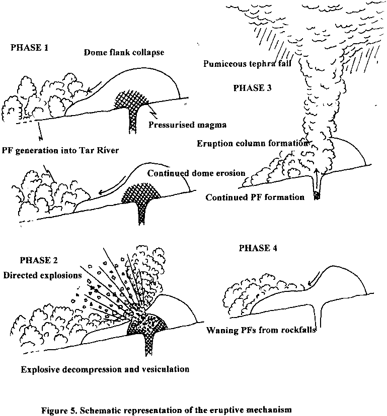
As indicated in section 3.2, the eruption of 17-18.9.96 can be considered to have started at around 11.30 on the morning of 17.9.96 with the semi-continuous production of PFs which traveled down the Tar River valley. This activity clearly represented the start of an initial dome-unroofing phase which ended at around 20.30 on the evening of 17.9.96. The seismic record for the period between this time and the onset of saturation of all instruments at 11.42 indicates a period of relative inactivity, within which episodes of stronger seismicity probably reflect the lower frequency (relative to earlier in the day) production of large rockfalls or further PFs. Comparison of the timing of the onset of instrument saturation with the loss-of-signal from the Hermitage seismometer suggests that the explosive ejection (or ejections) of dome-rock, which put the Hermitage out of action, did not coincide with the onset of this phase of activity. One interpretation that can be placed upon these observations, is that the activity which saturated the instruments at 11.42 involved a final phase of PF production that removed more dome material and reduced confining pressures to values which permitted explosive dome disruption. The outcome was the vesiculation of the unroofed, relatively gas-rich dome material, and probably the feeder conduit itself, and the triggering of a small pumiceous eruption which ended after 48 minutes of instrumental saturation. The observation that maximum lithic clasts in the deposit are larger than the aerodynamic equivalence of the pumice is consistent with an initial powerful lithic explosion column followed by a more sustained but less powerful pumice eruption. After this, activity was confined to the waning production of further PFs in the Tar River valley until around 03.30 on 18.9.96. A schematic reconstruction of the eruption is shown in FIGURE 5.

The depression made by the major collapse and explosion indicates removal of about 100 to 150 m of overburden. This is equivalent to a decompression of about 2.5 - 3.75 MPa (25 to 30 bars). Several observations are consistent with the internal pressure of the dome being close to its mechanical strength. First, VT earthquakes appear to be triggered by small stress changes associated with tidal forcing, suggesting that the system has very high pore-fluid pressures and is critically poised for fracturing. Second, the range of ballistic clasts at Long Ground require an internal dome pressure exceeding 5 MPa. Third, the vulcanian explosion requires pressures that exceed the tensile strength of the rock (about 20 MPa for cold rock, although hot, microcracked rock might be much weaker). Fourth, samples of dome rock from Long Ground contain tuffisite injection veins that require hydraulic fracturing of the interior of the growing dome for their formation.

6. Implications for Future Activity

Data gathered during the events of 17-18.9.96 will be invaluable in better constraining the type of future activity that can be expected at Soufriere Hills volcano. Most importantly, the eruption has shown that dome collapse can involve an explosive component, and that the recurrence of a similar event in the future is likely. This has important implications for hazard microzonation, particularly if the dome growth switches to another location, and account has already been taken of the events of the night of 17-18.9.96 in the preparation of the new series of hazard microzonation maps. The eruption also has important implications in terms of determining which are the critical observed phenomena on which the volcano alert levels should be based. In this context, for example, a sustained period of PF production - such as that recorded during the afternoon and early evening of 17.9.96 - would now trigger evacuation of the area south of the Belham Line before the potential for an explosive event was reached.

In terms of how often an event of the type produced on 17-18.9.96 can be expected in the future, it may be that several more dome-destruction episodes will need to be observed before this can be constrained. It is possible that explosivity will prove to be positively correlated with the volume of the dome, such that the confining pressures required to trigger an explosive phase of activity need a certain critical depth of overburden to be removed. In terms of forecasting future explosive dome collapses, the coincidence of a large, unstable dome and a period of high tidal stresses may, as suggested in section 2.1, provide the optimum conditions.

Key to MVO staff and associated researchers mentioned in report
PB Peter Baxter
CH Chloe Harford
AML Anne-Marie Lejeune
GM Glen Matteoli
BM Bill McGuire
BD Billy Darroux
LL Leroy Luke
GS George Skerrit
GN Gill Norton
RR Richard Robertson
GR Graham Ryan
RSJS Steve Sparks
NS Nicki Stevens
SY Simon Young

List of Figures

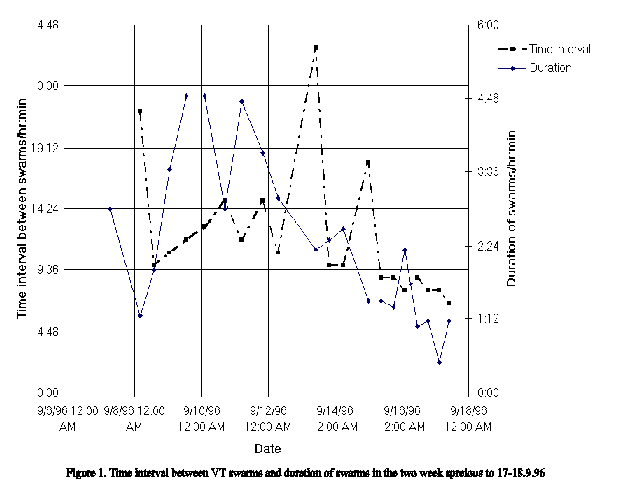
Figure 1. Time and duration of VT swarms in the days prior to the eruption of 17-18.9.96. (640x480 GIF 8K)

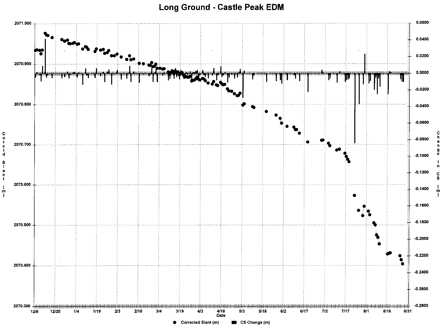
Figure 2. Long Ground-Castle Peak EDM since 12.6.96. (Reduced - 930x685 GIF 14K Large - 1800x1325 GIF 37K)

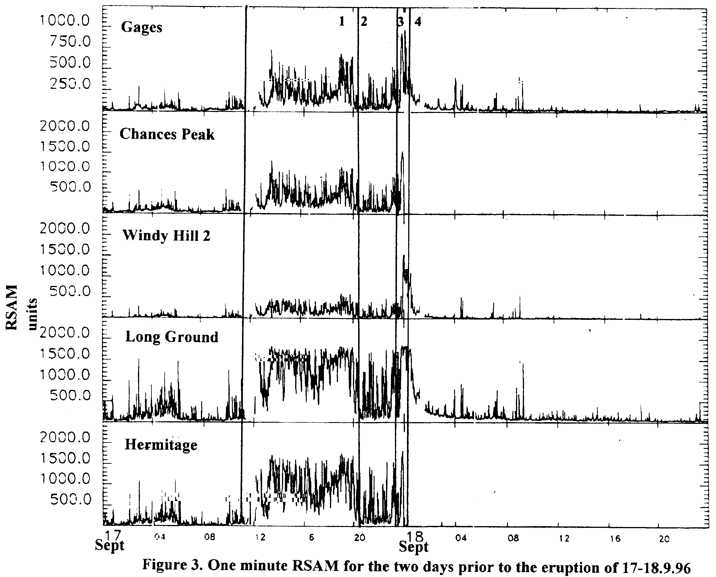
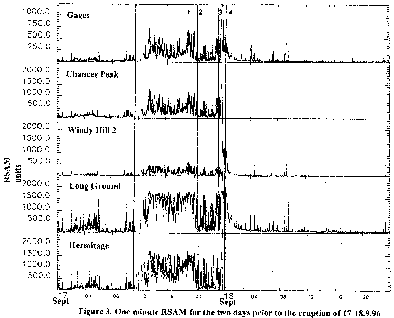
Figure 3. 1 minute RSAM for the two days prior to the eruption of 17-18.9.96. (Reduced - 765x620 GIF 19K Large - 2500x2010 GIF 104K)

Figure 4. Map showing tephra distribution following the eruption of 17-18.9.96. (305x395 GIF 68K)

Figure 5. Schematic representation of the eruptive mechanism. (Reduced - 770x830 GIF 19K 2270x2450 GIF 84K)


Montserrat Volcano Observatory