
Summary
Dome growth and pyroclastic flows have continued during the last two weeks, with pyroclastic flows descending the northern slopes of the volcano for the first time, with the longest flow reaching to almost 3 km from the crater. The flows were contained within Tuitt's Ghaut. Due to the shift in the activity, the volcanic risk map was revised, and several areas of the northern flanks moved into the zones of higher risk.
Visual Observations
Visual observations in this period have again been hampered by low cloud, with the whole dome being visible only on 30 th May and 8 th June. Dome growth has remained concentrated at the summit region and the northern flanks, with pyroclastic flows mostly on the northern flank into Tuitt's Ghaut and also eastwards into the Tar River valley.
At the beginning of the period much of the dome was actively shedding small volumes of material, and during a helicopter inspection on 27th May fresh deposits were noted on the northern, eastern and southern flanks. However the activity became more concentrated in subsequent days, with no new activity noted on the south and south-east sides. On 26th May, limited views of the south side of the dome were possible during a visit to Chances Peak. This area was also viewed on 1st June, during a 5-hour long occupation of the Galway's Observation post on the north-west ridge of South Soufriere Hills, and no rockfalls were seen during this time.
Moderate pyroclastic flows occurred in Tuitt's Ghaut for the first time. On 27th May, the dome was flush with the top of the crater wall at Tuitt's Ghaut, and pyroclastic flow deposits reaching 400 m down the ghaut were observed on 29th May. Further small pyroclastic flows occurred on subsequent days, and activity on the morning of 2nd June deposited fresh material to about 1 km from the crater rim, this was extended to 1.4 km on 3rd June. For about an hour on 4th June there was continuous pyroclastic flow production down Tuitt's Ghaut, with distinct pulses of higher velocity flows which travelled up to 1.8km down the ghaut.
The largest flows in Tuitt's Ghaut occurred on 5th June, when one flow at 12:07 pm extended about 2.9 km from the crater rim, it stopped only 200 m from the junction with Paradise River. A shorter flow, extending about 2 km from the crater rim occurred immediately afterwards. The upper reaches of the ghaut were shrouded in cloud at the time, but the flows in the lower part of the valley were observed and video taped from Harris Lookout.
The flows were confined to the narrow ghaut, and were quite slow moving, taking about three minutes to travel down the valley. All vegetation was stripped from the sides of the ghaut in the upper 500m. Lower down, the flows had been less destructive, with some trees still standing within the deposits. In straight parts of the ghaut, the surge did not extend more than 10 m from the edge of the deposit, but on corners the surge had ridden up the banks of the ghaut (the so-called bob sleigh effect). The front of the flow was marked by a pile of burned logs and coarse debris, and a finer-grained surge had travelled about 100 to 200 metres further down the ghaut. In the upper 1 km of the deposits there was evidence of several small, lobate flows. A single flow at 18:45 on 6th June travelled approximately 2km from the crater rim and observations of the deposits showed that the flow front was composed of particularly large boulders. There was significant widening of the notch in the crater wall through which the flows had travelled, with rockfall talus from the dome forming a smooth slope down into the top of the ghaut. For the remainder of the period only occasional small pyroclastic flows and rockfalls were observed in the ghaut.
Pyroclastic flows also occurred in the Tar River valley. On 27th May, a remarkable flow was generated high on the eastern side of the dome and it travelled all the way to the delta at the bottom of the valley. This flow reached the Tar River Estate House, a distance of 1.6km, in 20 to 25 seconds, i.e., a speed of 60 to 80 m/s. This is the fastest flow documented during this eruption. In the lower part of the valley the flow slowed considerably, and on reaching the delta stopped about 150m from the sea. Samples collected from this flow are pumiceous and contained hydrothermally altered clasts. Samples of the pyroclastic flow generated on 13th May are similar.
By 31st May talus slopes across the eastern and north eastern flanks of the dome had covered over the chutes that were formed by pyroclastic flows in mid-May, and the upper part of the eastern face looked more blocky. This side of the dome was relatively inactive.
Seismicity
The first part of this period showed a significant reduction in the number of hybrid and long-period earthquakes and the number of rockfall signals recorded by the seismic network. The hybrid earthquake swarms described in the previous report continued until 27th May, but each swarm lasted longer than the previous week's swarms, and there were longer time intervals between the swarms. The number of long-period earthquakes dropped to the lowest levels since mid-March, and at 0 to 4 events per day were back at normal background levels for this volcano during the present eruption. After 4th June, however, the number of both long-period and hybrid earthquakes increased again, and well over 50% of these triggered rockfalls.
For the first time since 15th May there were seismically detected rockfalls on the south side of the dome. However, the number of events in the south remained low, at a maximum of three per day. The number of rockfalls increased from 1st June, and for the rest of the period were exclusively concentrated on the northern and eastern sides of the dome.
There were regular periods on enhanced rockfall and pyroclastic flow activity, with about 16 to 20 hours between the start of each pulse. The pulses typically lasted for about 4 hours. In the lull periods, rockfalls continued although at greatly reduced levels.
Table 1: Earthquake types
These earthquake counts are of events that triggered the broadband network's event recording system between 0000 and 2400 each day (local time).
Date		VT	Hybrid	LP	Dome RF	LPRF*	HYRF*
25 May 97	0	32	11	121	9	3
26 May 97	1	86	1	49	0	0
27 May 97	4	78	0	63	0	4
28 May 97	0	9	2	90	1	1
29 May 97	0	9	3	76	3	2
30 May 97	0	4	5	72	3	2
31 May 97	0	12	4	57	2	1
01 June 97	0	4	3	106	1	3
02 June 97	0	0	6	111	3	0
03 June 97	0	8	5	126	5	5
04 June 97	0	3	1	148	0	2
05 June 97	0	5	9	144	7	4
06 June 97	0	14	11	100	5	8
07 June 97	0	13	22	84	10	4
*LPRF: LP earthquake followed by rockfall signal. HYRF: Hybrid earthquake followed by rockfall signal. The LPs, hybrids and rockfalls in these signals are also counted in their respective columns.
Table 2: Earthquake swarms (times are UTC)
Date		Strt	Stop	Durn 	#vt 	#hy 	#Gap to next (hrs)
25 May 97	11:33	15:36	4.05	0	28	21.35
26 May 97	08:54	17:31	10.62	1	86	25.56
27 May 97	10:28	23:15	12.78	4	72
Ground Deformation
A GPS occupation of Chances Peak was made on 4 June, running base stations at Harris and Windy Hill. The pin had moved a further 2cm to the west since the last measurement on 23 May. Crack 2 was measured on 4th and 8th of June showing continued dextral shear of 2.5cm since 23 May. Four separate, single-prism reflectors were installed on the southern flank of Chances Peak between the summit and Galways wall. Two reflectors were put on either side of the Crack 2. The reflectors point towards the South Soufriere Hills observation post and returns were obtained with the MVO Total Station as soon as the reflectors were in place.
A GPS occupation of EASTNET was made on 26 May. There were no dramatic changes since the previous occupation on 11 May. EDM measurements of the Northern triangle were made on June 3 and 7. There were no significant changes since the previous measurements on 24 May, although the Windy Hill - Farrells line has shown a slow shortening since January '97.
The tiltmeter on Chances Peak continued to show small inflation and deflation cycles, superimposed on a general trend of slight inflation. The cycles correlate with the observed pulses in rockfall activity, with the rockfalls occurring during the deflation phase.
Dome Volume Measurements
Dome volume surveys have been severely hampered by poor visibility however a set of static photos were obtained on the 31 May and 1 June during brief clear windows. Profiles traced from these photos show continued growth of the northern side and summit region of the dome. Points on the southern side of the dome obtained from the last dome survey were incorporated in this survey as it is considered that this area has been inactive during the reporting period. The photos were used to calculate the volume of the dome using the manual technique and yielded a volume of 64 57 x 106 m3. This indicates that the dome has been growing at a mean rate of 3.5 m3s-1 since the last dome survey on 19 May. As with the last survey this represents a rate considerably above the mean extrusion rate of 2.1 m3 s-1.
Environmental Monitoring
The pH of rainwater at sites north of the volcano remained very low until 28th May. During this period the fluoride content of the rainwater was also elevated. The pH and fluoride content returned to more normal levels when the wind direction changed to a west - northwesterly direction at the end of May (Table 3). Pipe water remains unaffected by the low pH of the rainwater (Table 4).
Table 3 Rainwater geochemistry
17th May to 25th May.
Location		pH	Cond.	TDS	Flrd	Chlrd	Slpht
				mS/cm	g/l	mg/l	mg/l	mg/l
Weekes			2.61	1.286	0.644	>1.50	133	5
Upper Amersham		1.96	7.24	3.62	0.20	1000	93

25th May to 28th May 97
Location		pH	Cond.	TDS	Flrd	Chlrd	Slpht
				mS/cm	g/l	mg/l	mg/l	mg/l
Weekes			2.52	1.557	0.778	>1.50	126	nd
Molyneux		2.57	1.312	0.657	>1.50	94	7
Dyer's			2.84	0.702	0.351	1.40	80	3
Lawyer's		3.03	0.46	0.23	1.25	52	nd
M.V.O			2.76	0.863	0.432	>1.50	80	3

27th May 97
Location		pH	Cond.	TDS	Flrd	Chlrd	Slpht
				mS/cm	g/l	mg/l	mg/l	mg/l
Hope			2.81	0.739	0.37	>1.50	70	nd

28th May to 1st June 97
Location		pH	Cond.	TDS	Flrd	Chlrd	Slpht
				mS/cm	g/l	mg/l	mg/l	mg/l
Weekes			3.45	0.257	0.128	1.20	*	3
M.V.O			5.33	0.066	0.033	0.35	*	nd
Dyer's			6.74	0.092	0.046	0.20	*	3

25th May to 1st June 97
Location		pH	Cond.	TDS	Flrd	Chlrd	Slpht
				mS/cm	g/l	mg/l	mg/l	mg/l
Upper Amersham		2.82	0.914	0.458	>1.50	*	12
Lower Amersham		3.11	0.533	0.267	1.15	*	18

Table 4  Pipe water geochemistry

17th to 25th May 97
Location		pH	Cond.	TDS	Flrd	Chlrd	Slpht
				mS/cm	g/l	mg/l	mg/l	mg/l
Amersham cattle trough	7.72	0.335	0.168	0.55	56	nd
(standing water)
Trial's reservoir 	7.86	0.827	0.414	0.35	112	42
overflow

25th May to 1st June 97
Location		pH	Cond.	TDS	Flrd	Chlrd	Slpht
				mS/cm	g/l	mg/l	mg/l	mg/l
Amersham cattle trough	8.89	0.32	0.16	0.35	*	nd
(from the tap)
Trial's res. overflow	7.80	0.845	0.423	0.30	*	38
nd: not detected
*: no chloride reagent available
Ash was collected from sites around the volcano on 1st June. The ash is noticeably fine compared to the last reporting period and small accretionary lapilli were common at the Plymouth sites. The ash was widely distributed from Brodericks to Dyers with the thickest ash fall (2mm) at Upper Amersham, Dagenham and Plymouth Police HQ.
Diffusion tubes measuring the averaged background SO2 since 17th May were collected on 1st June and have been sent to the UK for analysis. Results for the two week period up to 17th May show an increase in the background levels of SO2 particularly at Upper Amersham (Table 5). This relates to the increase in the level of volcanic activity at this time.
Table 5
SO2 concentrations (in ppb) from diffusion tubes at sites around the volcano. Recommended action level is 100 ppb.
Location			4th May to 17th May
Plymouth Police HQ			17.15
Upper Amersham				81.1
Lower Amersham				32.05
Weekes					4.3
Whites landfill				1.2
The miniCOSPEC is now being used daily, often both in the morning and afternoon to measure SO2 flux from the volcano. Daily averages during the reporting period are as follows:
Table 6: Daily average SO2 flux using miniCOSPEC
26th May		940 tonnes/day
27th May		971 tonnes/day
28th May		616 tonnes/day
29th May		770 tonnes/day
30th May		510 tonnes/day
2nd June		475 tonnes/day
3rd June		475 tonnes/day
4th June		2129 tonnes/day (helicopter)
5th June		2242 tonnes/day
6th June		642 tonnes/day
7th June		505 tonnes/day
The SO2 flux measured by the helicopter was exceptionally high on 4th June giving rise to doubts as to its reliability. However, a run through the central corridor using the normal COSPEC methods on 5th June gave very similar results suggesting that these values are realistic. This increased SO2 flux correlates with increased pyroclastic flow activity between 4th and 6th June.
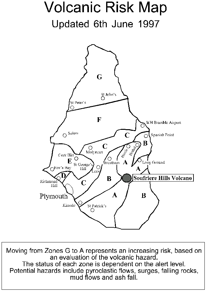
The Risk Map
A new risk map was presented to the local authorities on the morning of 5 June, and officially released on 6 June. Zone A has been expanded from the crater to the north as far as (and including) the village of Harris, and also includes Bramble and Bethel villages. The areas next to the new part of zone A were designated zone B, and include Tuitt's and Spanish Point on the eastern side and Streatham and Farrell's on the west. WH Bramble Airport, located about 5 km to the north-east of the volcano, was moved into zone C.
Staff Changes
Arrivals:
None
Departures:
Ouchi Osuji
Lloyd Lynch
Dr Willy Aspinall is the current chief scientist.