
Summary
A significant increase in activity occurred during this period involving collapse of the southern portion of the dome over the Galway's wall beginning on the 30 March and continuing through the Easter weekend. Pyroclastic flows travelled up to 3.6 km down the White river. A large scar was formed in the January dome and a significant portion of the pre-September scar material was removed.
Visual Observations
Activity increased at around 1:30pm on 30 March with large ash clouds (10,000 ft) associated with pyroclastic flows generated from the SE summit of the dome over topping the Galway's wall. Observations from the helicopter of the Galway's Soufriere region at around 2:30 - 3:00pm showed continuous or semi-continuous pyroclastic flow cascading over the Galway's wall. The formation of flows could clearly be seen to be pulsatory, with higher velocity flows surging through the smaller, slower-moving flows. Vigorously convecting, co-ignimbrite-type ash clouds rose to heights of >10,000 ft. Pyroclastic flow activity waned at around 4:30 pm. Observations before dusk on 30 March indicated flows had eroded a 30 m deep gully into the Galway's wall, and had travelled 3.6 km down the White River causing some burning of vegetation in the upper regions of the valley. Trees in the distal portion of the flows remained standing suggesting sluggish movement of flows in the lower part of the valley. Although considerable pyroclastic flow activity occurred during the early hours of 31 March these flows only travelled ~50 m further down the White river than the flows formed on 30 March. Further observations from the helicopter on 31 March showed that generally the pyroclastic flows were valley-confined, with very little pyroclastic surge component associated with them in the lower part. On the western side of the Galway's Soufriere region fine-grained deposits and tree flattening associated with pyroclastic surges was evident. Considerable ponding of pyroclastic flow deposits has occurred up to the level of the end of the road at the soufriere, and in the White river the Great Alps falls (originally 50m high) are now only ~10 m high.
A remarkable feature of this phase of activity is the erosive power of the pyroclastic flows which cut a gully up to 80m deep and 50m wide into the Galway's Wall. Growth of the dome since collapse and rockfall debris has rapidly begun to fill the scar. Observations of the collapse scar, termed the "Easter scar", formed in the dome complex showed to be composed of two scallops, one in the January dome with a near vertical headwall and the second cut into the pre-September dome forming about 40% of the material removed.
At around 3:00 pm and 3:15 pm on 31 March, two relatively large pyroclastic flows also occurred in the Tar River Valley sourcing from the NE summit of the dome. The first of these flows reached ~200 m past the first break in slope while the second larger flow reached to within ~50 m of the fan. Temperature patches positioned down the track leading into the Tar River valley were engulfed by the surge clouds of the latter flow, and indicated temperatures of 99-149C for distances of 60 m inside the pyroclastic surge.
Several relatively large pyroclastic flows occurred over the Galway's wall on 1st April beginning at 12:30pm producing large ash clouds to 14,000 ft which drifted NW producing ash fall over large part of the island including St Peters and St Johns in the north. None of these flows reached as far as those on the 30 and 31 March although considerably more tree flattening occurred in the area directly west of the Galway's Soufriere. This indicates that these flows had a larger surge component, probably due to the earlier valley filling allowing lateral spreading of the latter flows. Further pyroclastic flows over the Galway's Wall generated ash clouds to ~10,000 ft on 2 April.
Dome growth since the collapse has been confined to the Easter scar with upward and southward growth of the steep headwall. The actively growing area has a smooth, slabby, arcuate upper surface with local fractures and NS running striations indicative of extrusion. Vigorous, brown gas jets were seen emerging from cracks in the upper surface. Rockfall debris began to fill the chute carved by the pyroclastic flows into the Galway's wall toward the end of the reporting period.
Mudflows during the night of 3 and 4 April in Fort Ghaut and Aymer's Ghaut left debris on roads and close to houses.
Seismicity
The new broadband network, installed in October 1996, is now fully operational and is being used for routine monitoring. The network consists of 8 stations (Table 1), with 24-bit, 75 sps digital data telemetered to MVO. The 5 three-component seismometers are manufactured by Guralp, and have a frequency range of 30 seconds to 100 Hz (the sample rate restricts the upper frequency range to 30 Hz). Processing is carried out at MVO in near real-time, by trained local staff working in collaboration with visiting seismologists. Both continuous data and triggered events are recorded and archived.
Table 1: Locations of the stations in the broadband network
Station	Name			Type	No. of comps	Latitude	Longitude	Altitude (m)
MBGB	Garibaldi Hill		BB	3		16:43.94N	62:13.67W	253
MBGH	St George's Hill	BB	3		16:43.35N	62:12.52W	350
MBGA	Gages			BB	3		16:42.61N	62:11.32W	479
MBGE	Galway's Estate		BB	3		16:41.40N	62:11.62W	183
MBBE	Bethel			BB	3		16:44.61N	62:09.61W	102
MBWH	Windy Hill		SP	1		16:44.53N	62:11.45W	407
MBLG	Long Ground		SP	1		16:43.50N	62:09.74W	287
MBRY	Roaches Yard		SP	1		16:42.23N	62:09.19W	355
BB: Broadband; SP: Short-period.
Previous MVO reports contained event counts made from the short-period network, and future reports will use the broadband network data. There are some differences in the number of earthquakes recorded by each network (Table 2). On the whole, the broadband network is more sensitive, and records more events. There are also differences in the way that hybrid and volcano-tectonic (VT) earthquakes have been classified, and from now on MVO will adopt a new classification, based on analysis of the broadband data, and described below. The main other difference is that hypocentres from the short-period network are given with reference to sea level, whereas the broad-band analysis system gives hypocentres relative to 1 km above sea level (approximately the height of the top of the dome). In any case, the configuration of the networks restricts the hypocentre accuracy. Both networks will continue to run side-by-side at least for another few months.
Table 2: Earthquake types
These earthquake counts are of events that triggered the seismic networks
event recording systems between 0000 and 2400 each day (local time).
Date		VT		LP		Hybrid		Dome RF	LPRF*
		SP	BB	SP	BB	SP	BB	SP	BB	BB
30 MAR 97 	4	2	9	14	7	19	59	83	7
31 MAR 97 	2	3	10	22	3	13	44	75	12
01 APR 97 	4	0	32	42	18	21	39	73	9
02 APR 97 	10	0	11	40	32	41	58	85	18
03 APR 97 	56	27	12	4	39	68	15	30	1
04 APR 97 	15	6	2	3	23	22	28	41	0
05 APR 97 	27	28	4	3	0	2	27	25	2
*LPRF: LP earthquake followed by rockfall signal. The LPs and rockfalls in an LPRF signal are also counted in their respective columns.
In July 1996 there was a resurgence of shallow, so-called VT earthquake activity beneath the crater. Subsequent analysis has shown that there were two distinct event types (Table 3). Hybrid earthquakes are characterised by a low dominant frequency, with an impulsive onset and initial high-frequency component, especially at close stations. On the short-period system, these earthquakes were mostly classified as VT, with the hybrid classification reserved for small, low-frequency earthquakes that tended to occur repetitively. It is now recognised that many of these so-called VTs have a significant low-frequency coda, and should properly be called hybrids. True VT earthquakes have been rare since July 1996, and have occurred mostly in short swarms, in particular on 2 November 1996 and 3 April 1997 (see below).
Table 3: Classification of shallow earthquakes
Type		Frequency	Phases			Typical depths		Occurrence

VT		3-10 Hz		Clear P and S		2 to 4 km		Rare, with occasional swarms
Hybrid		1-4 Hz		Clear P, 		0 to 3 km		Common, in swarms.  Sometimes
				no discernible S	(poor constraint)	occur repetitively.
Long period	c. 1 Hz		No clear phases		Unknown,		Rare
							assumed shallow
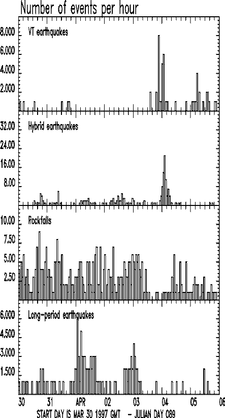
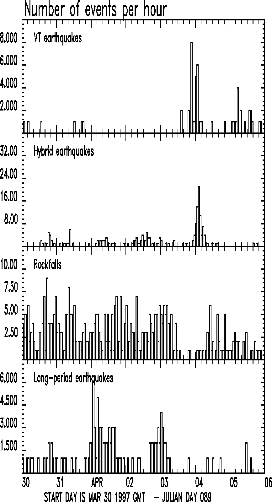
The week's seismicity was varied, comprising rockfall and pyroclastic flow signals due to the collapse of the southern section of the lava dome, and long-period, VT and hybrid earthquakes (Figure 1 440x820 GIF 870x1600 GIF). The beginning of the period was characterised by dome collapse signals. This was followed by an earthquake swarm, during which the number of dome rockfalls was dramatically reduced.
Between 31 March and 2 April, the dominant seismicity was related to dome collapse, with many rockfall and pyroclastic flow signals. Moderate pyroclastic flow signals were recorded at 14:35 on 30 March and at 03:34, 04:18 and 05:00 on 31 March. The close association of long-period earthquakes and rockfall signals continued, with typically the LP earthquake preceding the rockfall signal by about 5 seconds. On 30 and 31 March, the number of LPs maintained about the same level as the previous week. On 1 April, the number of LPs increased, with a maximum of 6 per hour recorded. The level of rockfall and long-period activity decreased abruptly on 3 April, and returned to normal levels of less than five earthquakes per day. Throughout the week, the proportion of earthquakes that triggered rockfalls varied, but averaged to 40%, similar to the previous week.
The LP signals are interpreted as a shallow source, probably within the dome. Large hybrid earthquakes have been observed to trigger rockfalls and Galway's Wall landslides in the past, due to direct shaking of volcanic edifice. However, the amplitudes of the LP earthquakes are much smaller than the hybrids, and therefore must be much shallower to cause rockfalls by direct shaking. Alternatively, the source of the LP earthquake may directly push the surface of the dome, causing a rockfall.
Shortly after the decline in rockfall and LP activity on 3 April, an earthquake swarm started. The swarm consisted of two sub-swarms, starting with VT activity, which subsided and was followed by hybrid earthquakes (Figure 1 440x820 GIF 870x1600 GIF). This swarm was very similar to a swarm recorded on 2 November 1996. VT earthquakes have been rare in recent months. They had clear S phases, especially at the closest station (MBGA), and hypocentre depths were about 3 to 4 km beneath the crater. The hybrid earthquakes were generally shallower, with hypocentres around 2 km, although these depths are poorly constrained due to the lack of S phases. Four of the hybrid earthquakes were relatively large, with estimated magnitudes around 3.
Following the earthquake swarm, rockfall activity increased again, although it did not reach the previous level. During 4 and 5 March, the number of rockfalls gradually decreased. There were few long-period earthquakes, and a few VTs.
Table 4: VT / hybrid earthquake swarms.
Date		Start time	Durn (hrs)	VTs	Hybrid
03 APR 97	17:10		4.72		21	0
03 APR 97	18:31		8.50		0	79
Ground Deformation
EDM measurements were made on the northern triangle (Windy Hill - St. George's Hill - Farrells). The point-to-point slant distances between Windy Hill to Farrells and St. George's Hill to Farrells continue to show very slow shortening. Changes in height are poorly resolved by this technique but there is some suggestion that there is some vertical movement taking place. Attempts are currently being made to clarify this.
The GPS network EASTNET was occupied on March 30th and 31st. The Farrells site has moved almost 4 cm to the north since the measurements began last June and the rate of movement appears to be increasing. A 20-hour occupation between Harris and Farrells on April 4th confirmed this result.
Both the GPS and EDM techniques indicate that there is slow deformation of the northern crater wall in the Farrells area. Examination of both sets of data indicates that the amount of deformation drops rapidly with distance from the dome. Neither technique is currently detecting any significant widespread deformation around the volcano.
Dome Volume Measurements
Although rockfall production and ash clouds from the region of the scar hampered surveying a GPS dome survey was carried out on the 2nd and completed on the 3rd April. This included a thourough survey of the new collapse scar. Results indicate that the collapse removed ~ 1.6 x 10⁶ m3 of material of which roughly 40% was pre-September 1996 scar material and 60% new dome material.
Environmental Monitoring
Measurements of sulphur dioxide flux were made using the MiniCOSPEC on 4 April (537 t/d). This value is over 3 times higher than the values for the previous week and reflects the increase in activity at the volcano.
Rain water samples was collected at 4 locations on 31 March, and results are shown in Table 5. The pH of the samples could not be measured since the electrode of the pH meter is broken. However, the samples will be stored, and the pH will be measured.
Table 5: Rain and surface water geochemistry, 31 Mar 97
Units: conductivity (mS/cm), total dissolved solids (g/l),
sulphate (mg/l), chloride (mg/l), fluoride (mg/l), nd (not detected)
Location	pH	Cond.	TDS	Slpht	Chlrd	Flrd
Upper Amersham	-	1.566	0.784	39	16.2	1.5
Lower Amersham	-	1.394	0.698	50	158	1.4
Police HQ	-	1.553	0.727	20	16.6	>1.5
Weekes		-	0.058	0.028	nd	10.3	0.2
Ash was collected at several sites to the west of the volcano after the pyroclastic flows on 31 March, and to the north and west of the volcano on 4 April. In Plymouth the maximum thickness of ash on 31 March was 16 mm at the American University of the Caribbean, and the total erupted airborne ash volume on 30-31 March was calculated to be 0.1 million cubic metres (dense rock equivalent).
Dust sampling in Plymouth and its surroundings continues with pumps at Cork Hill School, the port, Kinsale checkpoint, Monlec and various other sites. The samples have been sent to the UK for analysis.
Staff Changes
Arrivals
Mr Brian Baptie (BGS)
Departures
Mr Godfrey Almorales (SRU)
Figure 1: (440x820 GIF 870x1600 GIF). Number of seismic events of different classes per hour recorded by the broadband network. Note that time is UTC (local time + 4 hours). All other times in this report are local time.