
Summary
The level of volcanic activity has been low, and characterised by continued dome growth on the eastern side and periodic swarms of volcano-tectonic and hybrid earthquakes. The alert level was reduced from Orange to Amber on 17 February.
Visual Observations
Good views of the dome have been possible at times during the week, and the general picture is of continued growth in the south-eastern part of the dome, with few pyroclastic flows. The eastern face of the dome is steep.
Some changes to the top of the active face were observed, with large blocks moving slowly outwards. At night, some incandescence was observed from the active face. Towards the end of the week, deep gullies developed at the top of the face, and these glowed more intensely than the rest of the face. These gullies were the main source of rockfalls.
Several small pyroclastic flows were observed during the week, most of which were from the south-east part of the dome into the Tar River valley. The largest flows were on the night of 17 February, but did not reach as far as the break in slope, the position of the old road across the valley. The north-east part of the dome was more active, with some small pyroclastic flows on 18 February travelling towards the Farrell's wall.
Galway's wall continued to degrade slowly, with the three gullies in the top of the wall becoming more pronounced. A fresh rockfall deposit observed on 17 February extended as far as the previous longest flows (about 1 km from the dome).
Seismicity
The level of seismic activity has been moderate, with a continuation of regular swarms of earthquakes. No episodes of continuous tremor were recorded.
Table 1: Earthquake types
These earthquake counts are of events that triggered the short-period
seismic network event recording system between 0000 and 2400 each day.
Date		VT	LP	Hybrid	Dome RF
16 FEB 97 	89	0	1	9
17 FEB 97 	26	0	0	27
18 FEB 97 	95	0	36	8
19 FEB 97 	32	0	32	21
20 FEB 97	130	0	237	11
21 FEB 97 	28	0	139	20
22 FEB 97	125	0	100	2
Seismicity has been dominated by swarms of volcano-tectonic and hybrid earthquakes, with VTs dominating the first half of each swarm, and hybrids occurring mainly in the second half. Often, the hybrids were repetitive, particularly towards the end of each swarm, when earthquakes commonly occurred every 1-2 minutes. Unlike some of the swarms in previous weeks, these swarms did not culminate in periods of continuous tremor, although on occasion the hybrids joined together to form short periods of high-amplitude tremor.
The swarms have occurred regularly, with the time interval between the start of succeeding swarms decreasing from 24 to 14 hours, and then increasing again to 18 hours. The number of volcano-tectonic earthquakes in each swarm has fluctuated, while the number of hybrids generally increased through the week.
Table 2: VT / hybrid earthquake swarms and tremor episodes
Date		Start 	Durn	VTs	Hybrids	Gap* (hrs)
16 FEB 97	10:01	6.97	87	0	24.75
17 FEB 97	10:41	3.66	24	0	21.0
18 FEB 97	07:02	7.80	54	36	14.0
18 FEB 97	21:01	5.72	46	7	13.75
19 FEB 97	10:43	5.46	18	27	14.0
20 FEB 97	00:41	7.20	58	99	15.0
20 FEB 97	15:44	7.98	71	129	17.0
21 FEB 97	08:45	5.77	21	140	16.25
22 FEB 97	01:03	6.93	86	78	18.0
22 FEB 97	19:00	9.80	41	83
* Gap is time interval between start of swarms
Ground Deformation and Gravity Measurements
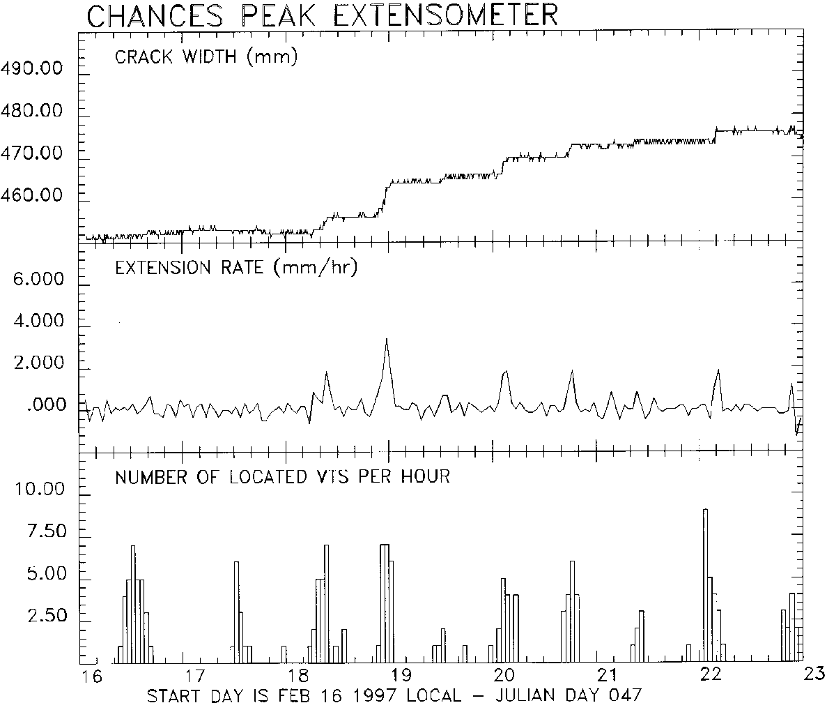
One of the cracks on Chances Peak (crack 2) showed increased deformation associated with some of the volcano-tectonic earthquake swarms.
Figure 1 (1190x1010 GIF 26K) Extension of crack near Chances Peak, recorded by a telemetered extensometer. Top panel: crack width; middle panel: rate of extension; bottom panel: number of located volcano-tectonic earthquakes per hour.This crack trends north-east and is located about 100 m from the hut on top of Chances Peak. An extensometer has been in place since mid-December and continuous data have been telemetered to the observatory. Five periods of increased deformation occurred, coincident with VT swarms. The maximum deformation rate was 8 mm in under 4 hours.
EDM measurements were made to the Chances Peak reflector on 17 February. The line from Galway's Plantation to Chances Peak had shortened by 18 mm since the last measurement on 2 December. This represents a slight decrease in the rate of movement of Chances Peak. Measurements were made on the western lines on 19 February. The line from Amersham to Chances Steps continues to show no significant deformation.
The GPS network BIGNET was occupied on 19 February. All baseline lengths were within two standard deviations of their longterm means.
Dome Volume Measurements
Dome surveys were carried out on 17 and 18 February by using both the kinematic GPS and the fixed location photographic methods. Data from these surveys were combined with data from the survey of 15 February in order to obtain a complete set of points with good coverage over the whole surface of the dome. The DEMs produced show that nearly all growth since 11 January (the last 'complete' survey) has been confined to an area in the SE of the dome that is within the scar of the January 20 collapse. This area is now over 60m higher than it was before the January 20 collapse and, as there have been no large pyroclastic flows or collapses in the recent period, it is evident that material is accumulating here faster than it is being shed. A small amount of material (<10m) has been lost from the northern face of the dome, where over the last few days occasional rockfalls have been generated which have reached the base of the talus apron on the northern side. Although at present there does not appear to be any active growth in this area, the persistent generation of small rockfalls suggests that this area is not totally inactive.
Dome volumes from this survey have been estimated by two methods: The volume increase since the survey of 11 January is 8.64 million cubic metres (this includes material added to the talus fan as far east as the break in slope which separates the talus from pyroclastic flow deposits of the Upper Tar River valley). This gives an extrusion rate between then and 17 February of 2.7 m3/s. As a check of this figure, and to help constrain errors, a second volume estimate was obtained by subtracting the current topography from the original English's crater topography. This method gave a total volume of 42 million cubic metres and hence an extrusion rate since 11 January of 3.2 m3/s. The survey from February 6 which covered only the actively growing area within the January 20 scar gave an extrusion rate of 2.9m3/s for the period January 28 - February 6 and so is consistent with the above results.
In conclusion, between 20 January and 22 February all dome growth has been confined to the area on the SE face of the dome within the January 20 scar. The extrusion rates vary from 2.7 to 3.2 m3/s which is slightly above 'baseline' extrusion rates as established since June 1996. The recent lack of large collapse events means that material is accumulating on the dome and its proximal talus apron. Dome profiles from two observation points show that since the end of December the dome has reached an approximately constant height (900 m) and is now spreading east into the Tar river valley.
Gas Measurements
COSPEC measurements were not made during this period as the COSPEC machine has malfunctioned.
Three sets of results from sulphur dioxide diffusion tubes were received. These are presented in Table 3 and show that levels of this gas are similar to those measured since the beginning of December. The levels measured at the airport continue to be low.
Table 3: Sulphur dioxide diffusion tube analyses (levels in ppb)
Location		Upper		Lower		Police HQ	Weekes	Airport	Control
			Amersham	Amersham	Plymouth

29.12.96 to 12.1.97	45.00		13.90		3.80		0.00	1.00	0.00
12.1.97 to 26.1.97	45.95		19.60		16.55		0.00	4.30	0.00
26.1.97 to 9.2.97	40.85		13.90		8.75		1.65	1.65	0.00
Environmental Monitoring
Rain water samples were collected at 4 locations around the volcano on 16 February, and results are in Table 4. One sample was also collected from run-off water by the side of the road to Upper Amersham on this date.
These results show that the rainwater directly west of the volcano continues to be highly acidic and has high concentrations of certain anions. Despite having high chloride concentration and high conductivity, the sample from the run-off water has near neutral pH.
Table 4: Rain and surface water geochemistry, 16 Feb 97
Units: conductivity (mS/cm), total dissolved solids (g/l),
sulphate (mg/l), chloride (mg/l), fluoride (mg/l),
		pH      Cond.   TDS     Slphts  Chlrds  Flrds
Upper Amersham	2.29	3.26	1.630	87	570	nd
Lower Amersham	2.58	1.327	0.665	52	194	1.40
Police HQ, 	2.59	1.135	0.568	22	335	>1.50
Plymouth
Weekes		5.89	0.152	0.075	nd	30	0.30
Amersham 	6.47	3.03	1.51	nd	900	1.25
Stream
No results on ash analyses were received during this period.
Staff Changes
Arrivals
Wilkie Balgobin, SRU
Visitors
Kenmuel Spence, Soufriere Monitoring Unit, St Vincent and the Grenadines Brian Baptie, BGS
Figure 1 1190x1010 GIF 26K: Extension of crack near Chances Peak, recorded by a telemetered extensometer. Top panel: crack width; middle panel: rate of extension; bottom panel: number of located volcano-tectonic earthquakes per hour.