
Summary
Dome growth continued in the south-east crater, above the Castle Peak area, although at a slightly lower rate than before. The new extrusion grew vertically at first, and then spread laterally. The number of rockfalls and pyroclastic flows increased during the period although it was at a low level generally. Seismic activity was dominated by swarms of volcano-tectonic earthquakes at shallow depths beneath the crater. Many of the swarms were followed by episodes of volcanic tremor. Hybrid earthquakes were also common, particularly towards the end of the period.
Visual Observations
Growth of the "January 20" dome continued, within the scar left by the dome collapse on 20 January. The new extrusion grew fast at first, and was composed of large blocks. The pre-existing radial cracks in the extrusion were filled in, and covered by fresh blocks. During the first week of growth, the extrusion was contained within the scar, and there were only a few rockfalls into the Tar River valley. The largest rockfall on 26 January reached only to the foot of the dome. On 28 and 29 January, rockfalls were more common to both the north and south of Castle Peak, and occasional small pyroclastic flows were observed. The vertical dome growth slowed, with the dome instead expanding laterally to the east and north-west. The remaining stump of the south section of Castle Peak gradually crumbled, with a large fallen block from the top of the peak seen alongside the stump on 29 January.
During the remainder of the period, frequent small pyroclastic flows occurred, often during episodes of tremor. Flows on the morning of 1 February caused an ash cloud that drifted to the north-west, depositing ash in Corkhill, Salem and Old Towne. The largest pyroclastic flows during the two-week period were on 6 February, when material just reached the sea at the bottom of the Tar River valley. Two flows on 7 February reached about half-way across the delta but not to the sea. The second flow was observed from the air and from Whites. During this flow, collapse of material caused four pulses of small-scale decompression, resulting in ash jetting and the generation of small projectiles from the south-east face of the dome. It was not possible to estimate the projectile size, but they were clearly visible from the helicopter about 1.5 km away.
During a dome inspection late on the afternoon of 2 February, coincident with an episode of tremor, small, glowing flows of fluidised ash and lava were seen from the area above Castle Peak, accompanied by fountains of ash. By 3 February, the remains of Castle Peak had been completely removed by pyroclastic flow activity. During the tremor episodes (see the seismicity section), there were no visible signs of increased activity.
Evidence of further landslides from the Galway's Wall, the southern part of the crater rim, was seen on 26, 27 and 28 January, with gradual crumbling of the top of the wall. A block fell from the western end of the wall, close to the eastern-most crack near Chances Peak, on 28 January, resulting in a mobile cold landslide that travelled about three-quarters of the way down the debris left by previous landslides. By 29 January, the centre part of the top of the wall was flush with the talus of the pre-September dome, and a small amount of dome material had fallen over the wall, leaving a small scoop in the dome.
The most significant development of the Galway's Wall during the period occurred sometime around 1-2 February, perhaps associated with the heavy rain at that time. A notch was cut through the upper wall at the western end, along one of the near-vertical zones of weakness in the wall. Dome material funnelled through the wall, and fell on top of the landslide deposits in the upper Galway's area. The notch was first seen on 4 February, and the volume of material involved did not seem to increase significantly during the rest of the week.
The weather conditions were very poor on 1 and 2 February. Heavy rain caused flash flooding in Fort Ghaut, with rocks, soil and ash washed down the ghaut, filling the lower reaches with thick deposits, damaging the upper bridge in Plymouth, and damaging or destroying four wooden buildings on the north bank. Much of the vegetation on the western slopes of the volcano has been destroyed by months of heavy ash fall and acidic rain. This has left the slopes exposed and vulnerable to heavy rain.
Seismicity
The main seismic activity has been regular swarms of volcano-tectonic and hybrid earthquakes, and episodes of high-amplitude tremor. The number of long-period earthquakes (dominant frequency 1 Hz) remains low, and the rockfall activity was low and fairly constant throughout the period.
Table 1: Earthquake types: 19 to 25 January 1996
These earthquake counts are of events that triggered the short-period
seismic network event recording system between 0000 and 2400 each day.
Date		VT	LP	Hybrid	Dome RF

26 JAN 97 	61	0	3	22
27 JAN 97 	54	6	25	47
28 JAN 97 	12	0	1	13
29 JAN 97 	67	0	4	11
30 JAN 97 	49	2	11	24
31 JAN 97 	 9	0	5	17
01 FEB 97 	38	0	4	27
02 FEB 97 	57	2	46	66
03 FEB 97 	92	0	28	48
04 FEB 97 	16	1	11	33
05 FEB 97	101	2	71	29
06 FEB 97 	52	0	43	21
07 FEB 97 	70	0	29	67
08 FEB 97 	15	0	213	45
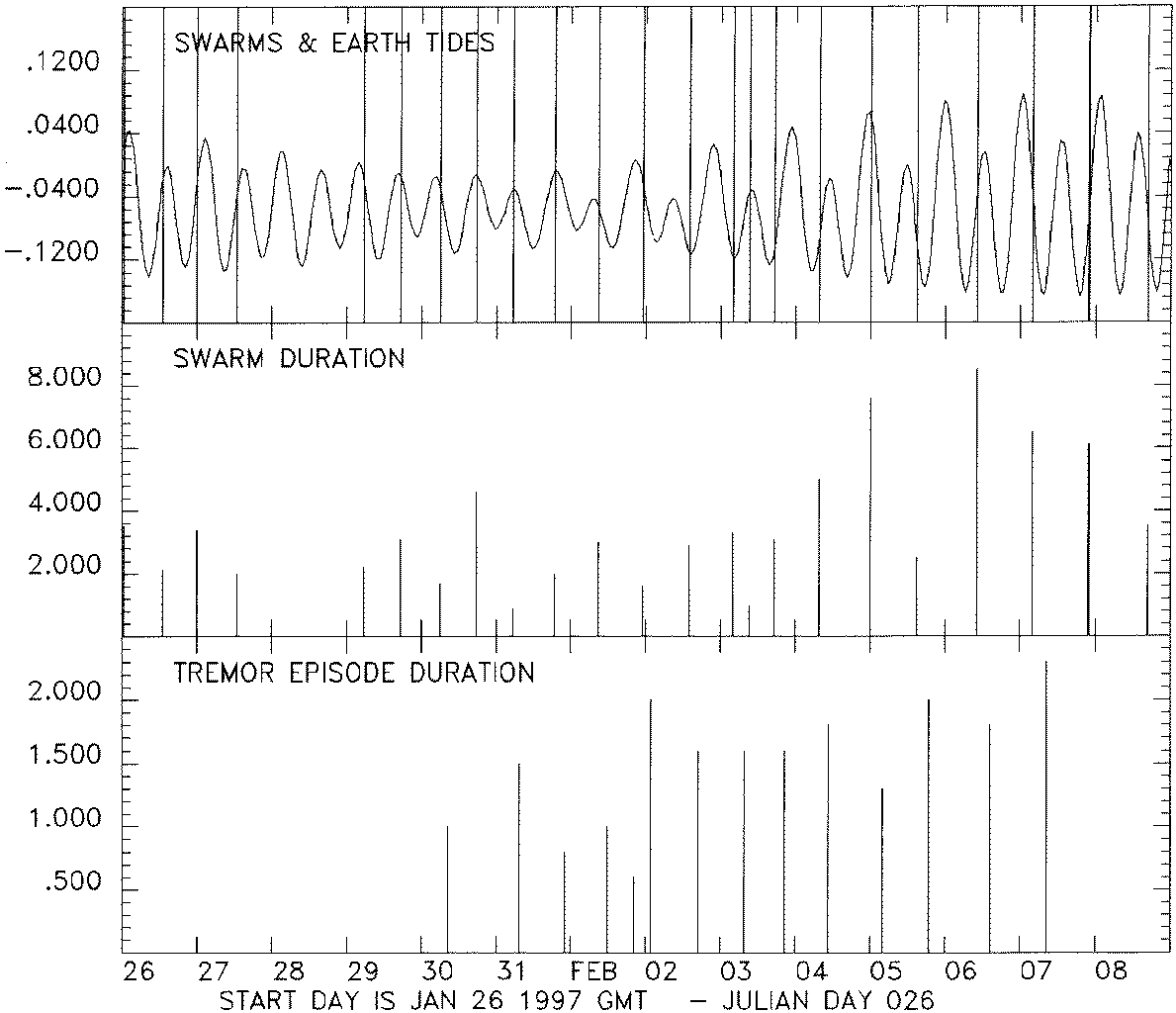
Figure 1 (Large 3290x2835 GIF 140K) (Small 1190x1024 GIF 36K) shows the start times of the earthquake swarms, and they are also tabulated below. For the first part of the period, from 26 January to 1 February, the swarms were regularly spaced, with approximately 12 hours between each swarm, apart from a gap on 28 January. The duration of the swarms was variable, but generally 1 to 2 hours. The swarms started at or just after the peak in the theoretical solid earth tide (Figure 1).
The pattern changed on 2 February, coinciding with an increase in the level of tremor. The tremor episodes increased in amplitude and duration between 30 January and 2 February, and were always preceded by earthquake swarms (Table 2). The episodes lasted for between 40 and 140 minutes, and usually showed a gradual increase in amplitude, followed by an abrupt decay. Sometimes the tremor built up gradually from background noise levels, but more often (particularly in the latter part of the period) the tremor started as individual hybrid earthquakes that grew in number until they formed a continuous signal. For about half of the episodes, pyroclastic flows occurred at or shortly after the peak in tremor.
The time between the earthquake swarms gradually increased between 2 and 7 February. The maximum tremor amplitude also increased, with the highest amplitude on 6 February. Thereafter the maximum tremor amplitude decayed, and no tremor was detected following the swarm on 8 February.
The tremor was generally non-harmonic, with frequency in the range 1 to 2.5 Hz. However, harmonic tremor was recorded during a short interval close to the peak intensity of a tremor episode on 6 February, and may have been present for short periods during other episodes. The dominant frequency of this tremor was 1.25 Hz.
Table 2: VT / hybrid earthquake swarms and tremor episodes
Date		Start	Durn	VTs	Hybrids	Trem strt Durn (hrs)

26 JAN 97	00:32	3.53	38	3
26 JAN 97	13:10	2.12	20	0
27 JAN 97	00:04	3.48	12	24
27 JAN 97	12:53	2.05	41	1
29 JAN 97	05:31	2.26	27	0
29 JAN 97	17:18	3.12	39	3
30 JAN 97	06:01	1.78	40	0	08:40	1.00
30 JAN 97	17:49	4.62	16	10
31 JAN 97	05:27	0.95	7	0	07:20	1.50
31 JAN 97	18:49	2.05	20	0	22:00	0.84
01 FEB 97	08:40	3.02	25	2	11:50	1.00
01 FEB 97	23:06	1.67	27	22	20:30	0.67
02 FEB 97	14:01	2.97	34	21	17:10	1.67
03 FEB 97	04:08	3.30	47	2	07:40	1.67
03 FEB 97	09:24	1.00	13	3
03 FEB 97	17:19	3.12	28	25	20:40	1.67
04 FEB 97	07:29	5.03	16	11	10:30	1.84
05 FEB 97	00:09	7.63	43	33	04:00	1.33
05 FEB 97	15:04	2.53	57	38	19:00	2.00
06 FEB 97	10:17	2.93	51	44	14:20	1.84
07 FEB 97	03:45	3.13	55	54	08:30	2.33
07 FEB 97	21:43	5.45	10	162
08 FEB 97	16:51	3.58	15	75
Ground Deformation and Gravity Measurements
A total of 52 new static gravity readings were made with 12 stations doubling as micro-gravity stations. Measurements were made along the western radial line, extending it from Lower Amersham to Plymouth shoreline and along the central corridor incorporating St George's Hill. On 1 February a Nettlton Profile across Whites Ghaut yielded a density of 2.1 Mgm-3.
The WESTNET and EASTNET GPS networks were occupied on 30th January and 4th February. All slope lengths were within 2 standard deviations of the long term means since June 1996.
Dome Volume Measurements
Volume measurements were made of the January 20 dome on 26 and 28 January, giving volumes of 1.46 and 1.52 million cubic metres respectively. An accumulation of 150 000 cubic metres of talus blocks developed at the base of the new extrusion in this period.
Poor visibility and difficult flying conditions hampered subsequent measurements. Visual observations suggest that collapse from the dome kept pace with the extrusion of new lava resulting in minimal net gain to the dome. A major talus field extending 1 km to the east of the dome developed in this period which obliterated the pre-existing topography in the upper reaches of the Tar River valley. A survey on 6 February indicated that around 2.3 million cubic metres of deposit formed in this region in 9 days, giving an extrusion rate between the 28 January and 6 February of 2.9 m3/s. The average extrusion rate for the January 20 dome up to 6 February was 2.7 m3/s.
Helicopter surveys of the delta at the mouth of the Tar River were carried out on 5 and 7 February. The total volume of the delta deposits is 14.9 million cubic metres, of which 7.4 million lies above sea level. The previous delta volume measurement made on 27 September 1996 gave a total volume of 11.6 million cubic metres with a sub-aerial volume of 4.9 million. The delta now extends 600 metres out to sea and is 1.3 km across at its widest point. The delta has not extended significantly since late-September, but has widened by 150 m and gained 10 m in height at the central point.
Gas Measurements
Measurements of sulphur dioxide flux were made with the COSPEC instrument from the road to the south-west of the volcano. The daily average for these days were:
29 Jan	796 t/d
31 Jan	495 t/d
4 Feb   323 t/d
6 Feb	446 t/d
7 Feb	652 t/d
During one set of runs on 7 February, the sulphur dioxide flux was highest during periods of volcanic tremor and pyroclastic flow activity (up to 871 t/d).
Environmental Monitoring
Sulphur dioxide diffusion tubes were collected on 26 January, and have been sent to the UK for analysis. No new results have been received.
Rain water samples were collected at 4 locations around the volcano on 26 January and 2 February, and results are in Table 3. In addition samples were collected at three locations on 28 January immediately after heavy rainfall. One sample was collected from Amersham Pond on 26 January. This pond has since been filled with ash and therefore it is not possible to collect any further samples from this location.
These results show that the rainwater directly west of the volcano continues to be highly acidic and has high concentrations of certain anions.
Place/Date	pH	Cond.	TDS	Sulphates	Chlorides	Fluorides
Upper Amersham
26-Jan-97	2.68	1.503	0.753	93		31.5		0.25
28-Jan-97	2.69	1.148	0.575
2-Feb-97	2.64	1.271	0.637	13		140		>1.5

Lower Amersham
26-Jan-97	3.09	1.983	0.994	nd		1000		nd
28-Jan-97	2.73	0.905	0.453
2-Feb-97	2.91	0.639	0.320	nd		66		1.45

Police HQ, Plymouth
26-Jan-97	3.19	1.01	0.506	nd		232		0.65
2-Feb-97	2.96	0.483	0.241	3		33.5		1.15

Weekes
26-Jan-97	4.83	0.186	0.093	14		50		0.4
28-Jan-97	6.29	0.06	0.029
2-Feb-97	2.74	0.894	0.447	3		78		>1.5

Amersham Pond
26-Jan-97	3.38	4.78	2.38	>1.5		500		850
Staff Changes
Departures
John Shepherd, Lancaster University / BGS
Rob Watts, BGS
Arrivals
Gill Norton, BGS
Joan Latchman, SRU
Eliza Calder, Bristol University / BGS
Figure 1: (Large 3290x2835 GIF 140K) (Small 1190x1024 GIF 36K) Distribution of earthquake swarms and tremor episodes during the reporting period. Top panel shows the start times of the earthquake swarms (vertical lines) and the magnitude of the theoretical solid earth tide, in arbitrary units. The bottom two panels show the duration of the individual earthquake swarms and tremor episodes.