
Summary
Surface activity during this fortnight was concentrated on the October 1 dome, initiated by increased rock fall activity, slight endogenous growth and then the appearance of new lava extruding at a markedly increased rate. By the end of the reporting period, the lava dome was once again approaching the size that it was prior to large-scale collapses during July to September 1996. Newly extruded material was markedly darker in colour than most material extruded during the current eruption, and also appeared hotter and less viscous. Over the reporting period the extrusion has formed a new cap of lava on the October 1 dome and a voluminous apron of talus in the Upper Tar River Valley. Seismic activity was dominated by swarms of hybrid earthquakes which coalesced to form continuous banded tremor, and by signals generated by rockfalls and pyroclastic flows. Measurable deformation was limited to the Castle Peak EDM reflector and the cracks on Chance's Peak. COSPEC measurements of SO2 gas flux were restarted for the second week of the reporting period. GPS and micro-gravity surveys continued around the flanks of the volcano.
Visual Observations
The reporting period started with no particular focus of growth on the October 1 dome. Rockfalls and small pyroclastic flows were sourced from a variety of areas on the dome, with no well-defined active front. Infra-red imagery confirmed day and especially night-time observations of active areas being distributed across the northern through to south-eastern sectors of the dome, although activity may have been more widespread. Theodolite and helicopter surveys of the dome during the early part of the reporting period both showed consistent inflation of its northern flank corresponding to 20 to 30 metres of uplift distributed across a zone 100 to 150 m in diameter. However there was little surface manifestation of this apart from the expression of weak lineaments on the flank which are possibly talus-covered fractures. The inflation was subordinate in scale compared to that noted in the southern part of the dome in early December.
New lava forming a thin lobe at the top of the October 1 dome was first seen on 26 December, and must have reached the surface sometime after 15:00 on 25 December. On 26 December the thickness the "Santa lobe" was about 20 m and its diameter about 100 m. It grew by thickening and spreading rapidly over the next few days, doubling in thickness and radius by 28 December. This growth was accompanied by the rapid accumulation of talus to the north, northeast, and east of the extrusion. The new lobe of lava spread predominantly to the north, northeast, east and southeast, although its front at first moved mainly eastward over its own talus. The new material on the dome appeared darker and less viscous than previous lava, with a marked absence of spines and large blocks either on the dome or in talus. However, the dome took on a more blocky appearance from 31 December. Incandescence both at night and during the daytime indicated higher surface temperatures at this time than during previous dome growth spurts.
During the initial period of extrusion, identifiable features on the October 1 dome northeastern margin responded by moving outward and downward, probably due to a combination of loading from above and swelling from within. Daily theodolite measurements on one feature showed a fairly consistent motion of about 15 m per day along a vector trending almost directly northeast (radial to the dome) and plunging about 25 degrees down, from 26 to 29 December. Such features were soon covered by the accumulating talus or lava of the new extrusion.
By 27 December, rockfall and pyroclastic flow activity had increased to such an extent that there was a continuous ash plume to a distance of c. 100 km to the west-southwest of Montserrat. Rockfall and pyroclastic flow activity increased somewhat on 1 January and continued at an elevated level for the remainder of the reporting period. Activity at this time began to focus in the area of Castle Peak, with material being shed from the eastern flank of the dome. The upper flanks of the Santa lobe were over-steepened in a number of areas, especially on the eastern side, and by 1 January had a distinctive coarse, slabby appearance. The arrangement of slabby lava near the flow front defined a spherically concentric or "onion-skin" structure. A 70 m-thick local accumulation of lava in a col over the Castle Peak dome generated the majority of ash through the spalling of dense slabs which disintegrated into block and ash flows. Most of these reached no farther than the base of the Castle Peak dome but sporadic larger flows commonly reached as far as the Tar River Soufriere. The increased dome activity led to a continuous ash plume travelling 200 miles or so from Montserrat at an altitude of c. 4,000 ft. The Castle Peak dome itself is under threat from erosion and burial by rockfalls passing by and over it. Rock falls and pyroclastic flows moved over the Castle Peak dome, to the north of Castle Peak itself and south of the shoulder of Castle Peak where the EDM reflector is mounted. This behaviour initially cut a deep erosional gully into the older rock which was later largely in-filled with fragmental material. Relatively little material has been shed into the gully south of Castle Peak (location of 19 December collapse) although lava has been banking against the remainder of the 11 December dome. The rock fall and pyroclastic flow activity was observed to occur in pulses which correlated well with peaks in seismic energy release and tiltmeter inflations. The peaks in surface activity appeared to occur shortly after the seismic energy and tiltmeter peaks. These peaks appear to reflect small pulses in lava eruption rate.
The Santa lobe remained confined on its western margin within the scar left in the pre-September dome after the events of 17/18 September 1996 and material mainly spilled out from the crater in north-easterly and south-easterly directions and only into the Tar River valley. The rapid dome growth was focused on the eastern flank of the dome, and the entire eastern side of the dome grew upwards and outwards by several tens of metres so that it overran Castle Peak.
No major changes to the Galway's Wall were noted during this period, although some small rock avalanches occurred from its thin upper part.
Heavy rainfall during 23 December caused small lahars in Fort Ghaut and White River, draining respectively the Gage's and Galway's crater walls. Renewed ash accumulation and vegetation damage in the catchment of Fort Ghaut provided sufficient sediment to the generate lahars lower in the valley, whilst continued rock avalanches and re-mobilisation of talus from the base of Galway's Wall provided sediment for the lahars in White River.
Seismicity
Seismicity during this period was highly variable in nature and at times reached very high levels. Table 1 shows the daily counts of the different types of earthquake recorded. These earthquake counts are of events that triggered the short-period seismic network event recording system between 0000 and 2400 each day.
Table 1: Earthquake types: 22 December 1996 to 4 January 1997
Date		VT	LP	Hybrid	Dome RF	Galway's Wall landslides

22 DEC 96	1	12	82	33	0
23 DEC 96	0	2	35	31	0
24 DEC 96	1	2	40	10	0
25 DEC 96	2	0	153	23	0
26 DEC 96	0	1	138	31	0
27 DEC 96	1	1	149	55	0
28 DEC 96	0	2	155	70	0
29 DEC 96	6	5	105	22	0
30 DEC 96	10	0	60	19	0
31 DEC 96	2	2	37	28	0
01 JAN 97	7	0	52	37	0
02 JAN 97	1	0	40	84	0
03 JAN 97	17	3	18	74	0
04 JAN 97	22	0	2	110	0
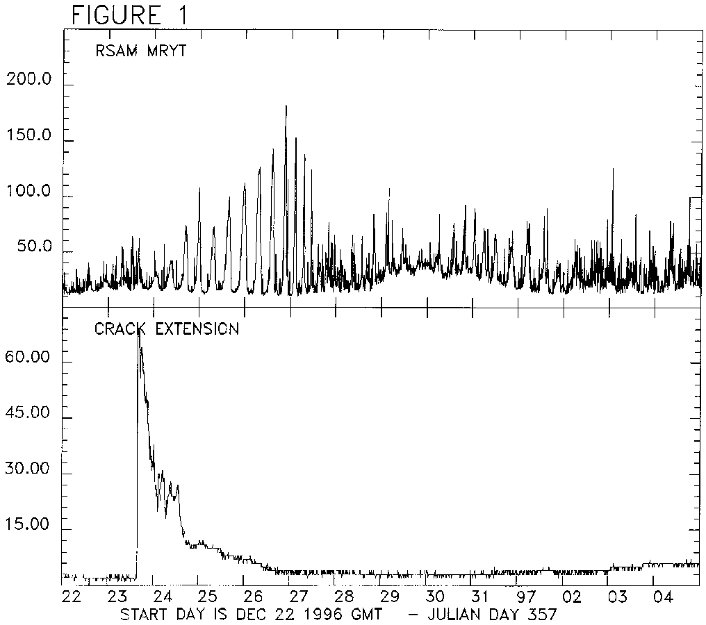
Up until 28 December, the seismicity was dominated by hybrid earthquakes and continuous seismic tremor. The tremor appears to be made up of numerous hybrid earthquakes which coalesce to give a continuous signal. The tremor was banded, i.e. occurring in short regularly-spaced bursts. Figure 1 (Large 2160x2435 GIF 77K Small 1015x900 GIF 23K) shows the RSAM data from the short-period station MRYT (Roaches Yard) for the reporting period. RSAM measures the average amplitude of a seismic signal in 10-minute windows and has proved effective in tracking variations in continuous signals. At first, the bands of tremor occurred at very regular intervals of approximately 8 hours. The tremor started at a very low level, emerging from the noise on 22 December. It slowly built up in amplitude over the next five days and by 26 December, it was very strong. The activity peaked in amplitude shortly before midnight on 26 December. The tremor changed character at this point. The time between the bands dropped to approximately 5 hours and successive bands were smaller in amplitude. Banded tremor had stopped by the end of 27 December.
The causes of this tremor are not known. Banded tremor was recorded in late July and much of August 1996. The period of tremor appears to have coincided with the opening and closing of one of the cracks on Chance's Peak discussed below. Figure 1 (Large 2160x2435 GIF 77K Small 1015x900 GIF 23K) shows the data from an extensometer deployed across the crack. The crack opened up suddenly at a time close to the start of the tremor and closed gradually, returning to its starting position by the end of 26 December, when the tremor changed character. The end of the tremor episode also seems to coincide with the extrusion of the Santa lobe (see above).
Hybrid seismic events continued to be recorded after the end of the tremor activity, in poorly-defined swarms. The banded tremor returned on 30 December, although much lower in amplitude than the first episode. The interval between the bands was 5 hours at first, although this lengthened to 10 hours on 31 December. The hybrid events at this time did not appear to be associated with the tremor. The tremor was very poorly defined after 2 January.
Signals from rockfalls, including pyroclastic flows, occurred throughout the fortnight. The level of rockfall activity was particularly high on 1,2 and 3 January, when the dome was growing at a fast rate.
Volcano-tectonic earthquakes were low in number until 3 January. Shallow VT swarm activity resumed at this point, with three short swarms of earthquakes. Between 1.5 and 4 hours long. The signals from these events were very similar to those that dominated the seismic records during November and early December. The January activity is also located under the crater area, but at slightly deeper depths, 2 to 3 km. The level of activity was much lower than that recorded during the peak of activity in mid-December.
The numbers of long-period earthquakes were low during this period, apart from a small swarm on 21/22 December. No Galway's Wall landslides were recorded.
Ground Deformation
A number of techniques are utilised for detection of ground movements at the Soufriere Hills volcano. EDM measurements to the Castle Peak reflector from White's Yard and Long Ground showed a 3 cm/day shortening rate early in the reporting period, which had lowered to 1.2 mm/day by 28 December. The high rate of deformation appears to have immediately preceded the increase in dome growth rate around 27 December, and this repeats a pattern seen on a number of occasions during the current dome-forming phase of the eruption. No reflections could be obtained from the Castle Peak reflector after 28 December due to heavy ashing; erosion of Castle Peak may mean the permanent loss of this reflector. Other measurements were attempted to the Chance's Peak reflector, but ash in the atmosphere and on the reflector prevented completion of measurements.
Occupations of the 'westnet' and 'bignet' GPS networks were undertaken during this period - the trend of no discernible deformation on the lower flanks of the volcano above the error of the technique continues.
Gravity data continues to be collected on a number of lines around the volcano. Changes in gravity have been noted in areas close to the summit crater - these changes are consistent with the added mass of the lava dome since the last surveys in June and early July 1996.
The extensometer and tiltmeters on Chance's Peak provided continuous data to MVO on the status of deformation close to the Galway's Wall throughout the reporting period, and physical measurements of the cracks on Chance's Peak were made on 31 December. The faster-opening crack closest to Galway's Wall showed an opening of 2 cm in 10 days. The extensometer on the crack further from Galway's Wall (see Figure 1 (Large 2160x2435 GIF 77K Small 1015x900 GIF 23K)) showed an instantaneous opening of c. 6 cm during a rain storm on 23 December and then returned back to its original width over the next 3 days; since that time it has shown a very slow opening of the crack at less than 1 mm per day. Physical measurements on the crack support the opening rate of less than 1 mm per day. The tiltmeters put in place close to the extensometer showed little change through this period.
The tiltmeter on Chance's Peak showed a general trend of tilting of c. 4 microradians per day toward the dome, up until 1 January, after which the rate of tilting slowed considerably. This is consistent with the microgravity results and again suggests that the crater rim is subsiding due to loading by the dome with possible slight superimposed deflation. There are also small but significant superimposed oscillations of about 2 microradian magnitude which correlate with rock fall activity peaks and RSAM peaks. The frequency of the oscillations varied but was on the scale of hours. The Long Ground tiltmeter showed no changes.
Dome Volume Measurements
Monitoring of the growth of the lava dome during the reporting period comprised a combination of theodolite measurements, fixed photographic surveys and heli-binocular-GPS surveys. A combination of all three of these techniques along with visual observations enabled a detailed dome surface map to be drawn and dome volume to be calculated. The total volume of dome material as calculated on 28 December was almost 28 million cubic metres, and the total extruded volume (dense rock equivalent) during the current eruption passed 50 million cubic metres during this period. The extrusion rate over the period from 25/26 December to 28 December, calculated from combining dense rock equivalent volumes of talus and lava on 28 December (approximately 1.8 million cubic metres), was about 8.3 cubic metres per second. This rate is similar to the previous highest rate of extrusion exhibited by this eruption, in the summer of 1996.
Gas Measurements
Measurement of sulphur dioxide in the gas plume was undertaken on 4 days during this period with a COSPEC machine on loan from the USGS. Measurements are taken along a road traverse from the Cork Hill area through Plymouth towards St Patrick's at an average distance of 4 km from the volcano. The results of these surveys are given in Table 2.
Table 2: Average daily SO2 flux (tonnes per day)
27 DEC 96	348
28 DEC 96	326
02 JAN 97	308
04 JAN 97	403
These values of SO2 in the plume are consistent with measurements taken during October but are markedly higher than values during May to mid-July and in November 1996. There were no marked variations in SO2 level related to changes in the level of seismic tremor beyond those normally seen during a series of daily runs.
Due to safety considerations, no sampling of the Galway's Soufriere is currently being undertaken.
Environmental Monitoring
Routine collection of water, ash and gas samples continues. Rainwater beneath the plume has a pH of between 3 and 4 and it and other parameters are varying little from week to week.
Other Work
Sampling of both the December 11 dome pyroclastic flows of 19 December and talus from the most recent phase of dome growth was undertaken on 31 December. The flows from the December 11 dome comprised mainly pumice in an ash matrix, with relatively few dense blocks or non-juvenile clasts. They are therefore markedly different from previous pyroclastic flows and were probably considerably more mobile. Preliminary analysis of the material from the new growth on the October 1 dome (the Santa lobe) suggests that it is compositionally the same as all of the previous material erupted so far; its darker colour may be due to oxidation. Further work on these samples is in progress.
Staff Changes
Arrivals
Sharon Teebenny, SRU
Uchi Osuji, SRU
Departures
Willy Aspinall, SRU
Sayadul Arafin, SRU
Lutchman Pollard, SRU