
This report covers the month of July 1996. It was written in February 1997, based partially on reports "Montserrat Volcanic Activity July 4 - August 11 1996, Report prepared for HE the Governor of Montserrat" by John B. Shepherd and Mark V. Stasiuk, "Banded tremor at Soufriere Hills Volcano" by Glenn Thompson, and on reports by Eliza Calder and Jane Toothill.
Summary
At the beginning of the month activity was at a low level. Seismic activity consisted mainly of rockfalls, with hybrid and long period events reported intermittently. The number of volcano-tectonic earthquakes remained low throughout the first half of the month.
Poor visibility considerably hampered views of the crater and dome volume estimates. Until about 20 July the growth of the dome was predominantly to the south with talus building against Galway's Wall. On the evening of 20 July a period of intense shallow earthquake activity began. Thereafter the area of dome growth and most of the visible rockfall activity was confined mainly to the eastern flank to the north of Castle Peak.
Visual Observations
On 1-3 July there was generally poor visibility; no significant rockfalls were observed from the previous area of active dome growth (check??) on the southern flank. A huge slab with a vertical crack down the middle had extruded at the top of the south-eastern section of the dome by 4 July. Also, fresh dome material, mainly in blocks, appeared in the upper reaches of Fort Ghaut. Between 4 and 7 July activity was concentrated on the southern flanks of the dome, and the huge slab first seem at the beginning of the month had developed into a second peak. This material was being extruded from a cleft region which ran east-west through the top of the dome dividing the active southern portion from the northern relatively inactive dome. Blocks being extruded southwards out of the cleft had smooth curved surfaces on their northern side and were bound by steep blocky areas on the southern edge. This distinctive symmetrical structure at the top of the dome was described as a 'crease' structure however it must be noted that no active extrusion from the cease was occurring in the northern side. Rockfalls continued to be concentrated on the southern side of the south peak, with material now building behind Galway's Wall so that the top of the wall was only about 10 metres above the talus. Considerable fumerolic activity was noted in the cleft between the two peaks.
By 10 July the activity had spread, with rockfalls noted down the east to south-east sector of the dome. Fresh material accumulated on the south side of Castle Peak indicating continuing active growth. The area behind Castle Peak was seen to be steaming vigorously with fumerolic activity coming from the summit of the south-east peak and from the cleft between the two peaks.
At least one minor phreatic explosion occurred about 10 July. The ash deposits on Chances Peak were showered with small hydrothermally altered fragments on about that date, to a distance of about 500 m from the crater rim. One blast was witnessed from Old Towne on 10 July, and apparently occurred on an inactive flank of the dome.
A small amount of new material appeared over Gage's Wall and up against Galway's Wall on 16 July. Most of the rockfall activity was concentrated on the south-western flank of the dome with small pyroclastic flows on the eastern flank.
Between 16-20 July the visibility was again poor, with frequent rockfall activity heard descending the north-east flank. Fresh deposits were seen in the southern and northern sections of the upper Tar River valley on 21 July. A few rockfalls were observed from the eastern, north-eastern and northern flanks of the dome. There was a low level of steam emission from the lower sections of the dome.
From approximately 20 July onward, the area of growth on the lava dome shifted to the east, close to Castle Peak. At about that time the dome growth rate increased dramatically. The change was signalled by increasing numbers of hot rockfalls from the steepening, blocky surface of the dome in the eastern and north-eastern sectors. On 24 July the volcano showed a clear increase in its level of activity with a sharp increase in rockfalls off the NE dome flanks and in the level of seismic activity (see below).
On 26 July, brief glimpses of the eastern sector of the dome through breaks in cloud cover revealed a new spine with an upward tapering form, about 50 m high and 50 m in diameter at its base. Clear conditions during the night of 27 July allowed extensive observation of the actively extruding spine. Incandescent rockfalls of metre-sized blocks were produced by almost continuous spalling from the spine shoulders.
Throughout 28 July almost continuous rockfalls and small pyroclastic flows were generated in the upper Tar River valley. During the early part of the day the small pyroclastic flows did not travel further than the disused north-south road in the valley but they generated moderate-sized ash clouds which were blown to the west and resulted in moderate ash fall in most regions to the west of the volcano. From about 17:45 onwards the pyroclastic flows appeared to increase in size although they were not under direct observation. A continuous series of ash columns was generated which drifted to the west and resulted in light ash fall in Plymouth and surrounding regions.
During the period 25-29 July the rate of growth of the dome was estimated to have risen to 10-15 cubic meters per second, amongst the highest sustained rates recorded in historical dome-growth eruptions. During this period the vigour of collapsing material from the dome escalated. Small, regular rockfalls were observed to have runouts of perhaps 200 metres and to generate minor, dilute ash clouds at the start of the period, but these progressed to nearly continuous block and ash flows having runouts of 800 metres, velocities of about 70 km/h, with associated active surge clouds and generated columns about 1 km high.
A major series of pyroclastic flows generated ash columns from 05:30 on 29 July. During the morning of 29 July the new intrusion through the eastern flanks of the dome was observed briefly. The shape had changed from a truncated cone to a flat-topped plateau. Beginning at about 12:00 and again at 16:00 major periods of pyroclastic flow activity generated major ash columns which were carried by the wind in a south-easterly direction and deposited ash to a thickness of a few centimetres in St.Patricks. The period of 16:00 produced flows which reached the sea and were observed from the helicopter. These flows moved much more rapidly than the shorter flows observed earlier, and were much more mobile. The associated ash clouds clung to and followed nearly vertical cliffs.
The pyroclastic flows which reached the sea at the mouth of the Hot River built a fan which, by 4 August, when it was surveyed in detail, extended about 400 meters into the sea and was about 550 meters wide at its base. The fan was built by a long series of pulsed flows, rather than one major event, but include blocks up to several meters in diameter. The flows caused extensive denudation of the Tar River valley in a swathe which was 500 meters wide in places. None of the pyroclastic flows over-topped the rim of English's Crater nor the main valley wall of the Tar River Valley, although significant surge deposits over-topped at the head of White's Ghaut and proceeded about 50 metres down the ghaut, leaving scorched vegetation and knocking down small trees. Vegetation was scorched to the top of the north Tar River Valley wall in almost all locations. Almost all vegetation was removed from the Tar River Valley by the flows, and only minor scorched trees on steep leeward slopes and blown down or bent, charred trees high on the valley walls were left rooted. Brief views at night revealed that the north-east sector of the dome continued to grow and showed a similar behaviour to that on 27 July, with nearly continuous incandescent rockfalls from the upper margins of the extruding material. On 30 July partial clearing allowed helicopter observations of the north-east sector and revealed that the collapses of the previous day had not removed the entire spine (or it had been replaced by continued extrusion). The north-east sector appeared to be only the jagged root of the recently extruded spine and was composed of a thick sheaf of dark-coloured slabs about 1 metre thick, with intervening scoriaceous material. This material was surrounded by fresh talus ridges which joined at the spine base and led continued rockfall material to a new erosional gully in the talus along the south margin of the Castle Peak. The helicopter altimeter indicated that the top of the new material was at a height of 2800 feet above sea level.
The rate of extrusion continued at the elevated rate established around 24 July until the end of the month. Again the rockfall behaviour escalated rapidly in vigour and on 31 July at about noon there were more large pyroclastic flows which reached the sea, extended the pyroclastic fan, further denuded the Tar River Valley and generated ash plumes up to about 15,000 ft with associated lightning. The entrance of the flows into the sea generated vigorous boiling of the sea, and a large steam plume which mixed with the ash plumes from the pyroclastic flows. It appeared that this mixing of steam produced rains of accretionary lapilli and hence premature ash deposition. The collapses removed a major part of the dome, including more than the recently extruded spine and probably much of the material which began to be extruded in early July. The collapses left a spoon-shaped depression which cut mainly through the eastern talus slopes but extended upwards above and behind the old Castle Peak dome. The volume of material lost was estimated to be in the range 3-5 million cubic meters. Profiles across the Upper Tar River Valley show that very little material was deposited except along the narrow axes of the deep gullies. The surge deposit thickness reached local maxima of 70 cm and the blocky pyroclastic flow deposits in the gullies had thicknesses up to about 15 m. The greater changes to the valley were a planing off of pre-existing material. Some small ridges, hills and irregularities were removed, and in one location the pre-existing ground surface was eroded down by about 25 m. These observations are consistent with preliminary volume estimates of the pyroclastic fan at the shore which have reasonable maxima somewhat greater than 5 million cubic metres of dense rock on 4 August. That is, as much or more material reached the sea than collapsed from the dome. The implications are that the pyroclastic flows were very mobile, probably stopped by entrance into the sea, and were highly erosive.
Seismicity
Until 20 July the level of seismic activity was low. Volcano-tectonic earthquakes were very rare, and there were occasional long-period and hybrid earthquakes. The activity changed substantially on 20 July, and the seismic activity was at a high level for the rest of the month, with repetitive earthquake swarms and episodes of tremor.
Table 1: Earthquake types: 1 to 31 July 1996
These earthquake counts are of events that triggered the short-period
seismic network event recording system between 0000 and 2400 each day.
Date		VT	LP	Hybrid	Dome RF
01 JUL 96	1	9	12	61
02 JUL 96	2	9	26	64
03 JUL 96	0	1	21	35
04 JUL 96	0	5	10	24
05 JUL 96	0	8	20	27
06 JUL 96	1	8	5	32
07 JUL 96	0	11	4	10
08 JUL 96	1	3	4	4
09 JUL 96	3	3	5	18
10 JUL 96	4	5	2	27
11 JUL 96	2	7	3	26
12 JUL 96	4	9	14	9
13 JUL 96	2	11	20	14
14 JUL 96	2	24	2	14
15 JUL 96	2	11	13	17
16 JUL 96	2	12	15	20
17 JUL 96	0	12	15	23
18 JUL 96	0	11	15	13
19 JUL 96	4	8	13	25
20 JUL 96	43	13	21	28
21 JUL 96	56	34	87	45
22 JUL 96	49	40	125	44
23 JUL 96	8	14	9	25
24 JUL 96	16	3	7	24
25 JUL 96	83	4	38	21
26 JUL 96	64	10	18	37
27 JUL 96	5	3	9	47
28 JUL 96	13	4	8	85
29 JUL 96	23	3	34	115
30 JUL 96	11	0	104	58
31 JUL 96	88	0	178	93
The first 20 days of the month were characterised by low-level seismicity, with less than 50 earthquakes recorded per day. The number of long-period earthquakes increased prior to the increase in other types of activity, then declined towards the end of the month. These long-period earthquakes were large enough to be recorded by most stations on the network, and had a magnitude of about 1 (duration 20 seconds). The number of rockfall signals was low.
In the evening of 20 July, the seismic network recorded a swarm of impulsive events (VTs), the first since November 1995. Most of these earthquakes were too small to trigger the recording system, but about 560 events were visible on the Gages helicorder on 20-21 July. Between 21 and 25 July the seismic activity continued at an elevated level, with increased numbers of all types of events. VT earthquake swarms occurred on 25 and 26 July.
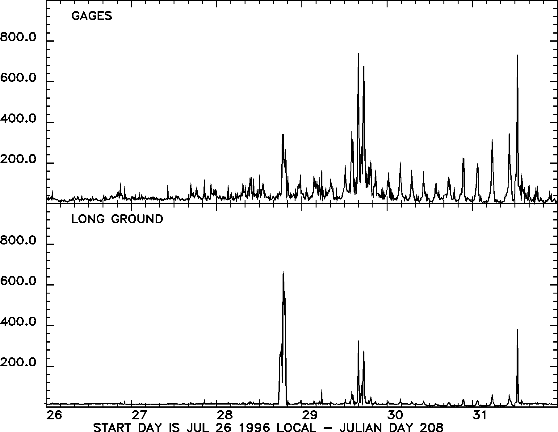
Between 25 and 27 July, faint episodes of low-amplitude banded tremor were visible on the helicorder records. On 27 July, an unprecedented period of enhanced seismic activity began, with episodes of continuous high-amplitude tremor. Between 27 and 31 July, the tremor episodes typically lasted for about one hour and recurred with a four-hour repeat interval (Table 2). Relatively quiet periods were punctuated by increasing numbers of repetitive hybrid-type earthquakes which eventually merged into periods of continuous tremor before settling back to background level. On 30 and 31 July, the tremor episodes were preceded by volcano-tectonic and hybrid earthquake swarms (Figure 2 1350x1630 GIF), and this pattern continued into August.

The amplitude built up gradually to a maximum amplitude and decayed either symmetrically or sharply. The maximum amplitude of the tremor episodes increased between 27 and 29 July, and thereafter was approximately uniform, before increasing again prior to the pyroclastic flows on 30 July (Figure 1 (1810x1400 GIF). From 29 July until early August, the tremor was strong enough to saturate all the high-gain, short-period stations in operation. Major collapses occurred coincident with tremor episodes on 28, 29 and 31 July (see Visual Observation section).
Detailed analysis of the frequency of banded tremor episodes has not been possible. Limited SSAM data for the end of July and beginning of August shows that tremor at that time had a broad spectral peak between 2 and 5 Hz. Some of the helicorder records show periods of tremor that appear harmonic with a dominant frequency of 1.5 Hz, although it is impossible to confirm this, because the records are clipped.
Table 2: Tremor episodes 1 to 31 July.
Date		Start	Duration (hrs)
27 JUL 96	18:00	1.33
28 JUL 96	22:39	1.18
29 JUL 96	03:00	1.17
29 JUL 96	07:25	1.15
29 JUL 96	11:38	0.70
29 JUL 96	13:21	1.07
29 JUL 96	15:20	2.52
29 JUL 96	23:50	0.68
30 JUL 96	03:10	1.00
30 JUL 96	06:25	0.95
30 JUL 96	09:28	1.17
30 JUL 96	13:17	1.47
30 JUL 96	16:40	1.07
30 JUL 96	20:50	0.72
31 JUL 96	00:30	1.07
31 JUL 96	04:40	1.22
31 JUL 96	09:30	1.53
Ground Deformation and Gravity Measurements
Total Station (EDM) measurements continued on the eastern and northern triangles whenever visibility permitted. The reflector at Chances Peak (the southern triangle) was obscured by mist and a constant light drizzle of ash throughout the month.
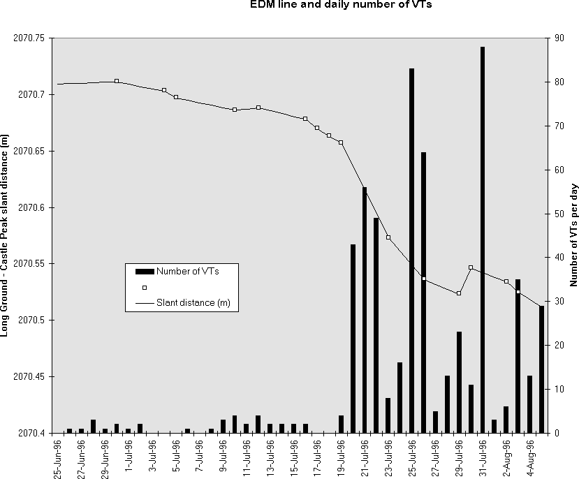
The shortening of the lines from Castle Peak to Whites and Long Ground continued at an accelerating rate but no significant changes were detected on the northern triangle. Between 16 and 19 July, the rate of shortening on the Castle Peak lines increased to 6-8 mm per day, and rates about 18 mm per day were recorded between 19 and 26 July. This was is about one order of magnitude greater than the mean rate measured since December 1995. The change in rate of deformation correlates with the resumption of VT earthquake activity (Figure 3).
Two complementary programmes of GPS measurements were continued throughout this period. The University of Puerto Rico programme which began in August 1995 measures baseline lengths on a number of lines which are of order 5-6 km long and which cross the whole volcanic edifice. Previously measurements on these lines were made at irregular intervals but two continuously-operating stations were established.
The MVO GPS program measured baseline lengths over shorter distances (average 2 - 3 km) using the Rapid Static method. In terms of deformation of the volcanic edifice, the results of the two programs were in agreement. Some baseline lengths show generally incoherent short-term variations of the order of a few centimetres. It is not yet clear whether these short term variations are of instrumental origin or whether they have a genuine volcanic origin. When the results are averaged over more than a few days there are no long-term deformation trends at levels greater than one standard deviation of the measurements. One exception to this general result involves the UPR measurements to the Chance's Peak site which continue to show displacements above the one sigma level indicating continued outward movement. Taken in conjunction with the continued displacements on the Total Station lines to Castle Peak (and absence of significant displacements on other lines) these results strongly indicate that deformation associated with this eruption is confined to a region not more than one kilometre from the growing dome.
In conjunction with the MVO GPS programme, a comprehensive gravity survey of the volcano was carried out between 12 and 27 July. A total of over one hundred new gravity stations were occupied and simultaneously located by GPS. These stations are mainly in a number of lines radial to the volcano passing up the steps to Chances Peak, through Plymouth to Gage's Soufriere, from Farrells to the crater rim, from Whites to Hermitage, and from Perche's Estate to Roaches Mountain. A preliminary gravity map of the volcano is in preparation. Twenty-three of these stations were selected as microgravity monitoring stations and will be re-occupied.
Dome Volume Measurements
Dome volume estimates were made using the fixed location photographic method on the 30 June, 7 July and 17 July. However poor visibility during much of this time period, and growth in the southern sector of the dome which was difficult to constrain with the photographic method, made the development of a new technique necessary. This new "Kinematic survey" method involves using the helicopter, GPS and laser range-finding binoculars. The range-finding binoculars allow the observer to estimate the distance, azimuth and declination of a point on the dome while the helicopter remains in a fixed position, and the GPS obtains a position relative to a fixed station on the ground. These co-ordinates can then be transferred into a software package which constructs a three dimensional surface and calculates volumes.
Unfortunately the kinematic survey method was not fully operational until the survey of the 9 August and so the volumes estimated for the 24 July and the 29 July were constrained using visual observations, simple geometric calculations and other information.
Table 3: Dome volume measurements, 30 June to 9 August 1996
Date		Dome vol		Total vol extruded	Extrusion rate
		(DRE)	(DRE)		m3 / day		m3 / second
		M m3	M m3
30-JUN-96	20.93	24.91		200000			2.3
07-JUL-96	22.03	26.01		137500			1.59
17-JUL-96	22.99	26.97		96000			1.11
24-JUL-96	23.62	27.64		96000			1.11
29-JUL-96	27.55	31.48		768000			8.88
09-AUG-96	26.42	33.51		169000			1.96
Until 20 July the growth rate was similar to the previous weeks, averaging around 2m3/s. Growth maps between 9 June and 30 June showed major areas of growth to be on the top of the dome to the south (where the large block had been extruded) and filling of the moat in the south against the Galway's Wall, the north west against the Gages Wall and in the west against Chance's Peak.
A substantial amount of material was shed from the dome on the southern side of Castle peak due to the main focus of the activity switching to this side. Only the tip of the massive block on the southern side was visible from Harris Lookout and although a larger portion of it was visible from Whites it was difficult to accurately constrain the full extent of this volume using the photographic method, and many points for the survey in that region had to be extrapolated.
By 7 July the massive protruding block on the southern side had developed into a 'second peak'. The cleft running between the two peaks separating the actively extruding material in the south from the inactive northern part had a depth of 30 m. Talus had built up significantly in the region next to the Galway's Wall and the growth since the previous survey was concentrated in the region of the second peak. Again the active growth area on the south was largely obscured and the photographs from the fixed position site had poor coverage of this part of the dome.
For the survey of 17 July fixed position photographs were also taken from Roche's mountain and the Tar river EDM point in order to better constrain growth in the southern region of the dome. Visual observations after that time suggest the growth rate increased dramatically with the growth switching back to the north and north eastern part of the dome. The volume estimate of 24 July is very poorly constrained but the estimate of the 29 July reflects the exceptionally high extrusion rate for that time period and represents the highest rates since the eruption first began, between 4 and 5 times higher than previous estimates. The volume of the scoop taken out of the dome on the collapse of 29 July was estimated to be 8.5 million cubic metres (roughly a third of the dome). By 9 August this volume had been filled in. By 9 August the rate had settled back to the baseline figure.
Gas Measurements
Table 4: Daily sulpur dioxide flux measured using the COSPEC instrument
Date		Average flux (t/d)
10 JUL 96	91
20 JUL 96	137
21 JUL 96	112
22 JUL 96	172
23 JUL 96	103
24 JUL 96	225
26 JUL 96	411
27 JUL 96	136
28 JUL 96	282
Environmental Monitoring
The sampling program of fumarolic gases at Galways Soufriere continued.
Sulphur dioxide diffusion tubes were installed at locations in and around Plymouth. Tubes are collected and replaced approximately every 14 days. The sampling periods through July were from 30 June to 7 July and from 8 July to 22 July. Results are shown in Table 5, and show values within acceptable levels for human health. Another set of tubes were put at the same locations on 22 July.
Table 5: Sulphur dioxide diffusion tube results for July. Levels are in ppb.
			30.06.96 to	08.07.96 to
Location		07.07.96	22.07.96
Upper Amersham		14.25		42.95
Lower Amersham		7.65		12.45
Police HQ, Plymouth	2.80		3.90
Observatory		0.40		0.00
Weekes			0.00		1.45
Water samples taken at four sites around the volcano were tested for pH, conductivity, total dissolved solids, sulphate, fluoride and chloride and show no significant changes. Results are shown in Table 6.
Table 6. Chemistry of rainwater from 4 sites around the volcano
Units: conductivity (mS/cm), total dissolved solids (g/l),
sulphate (mg/l), chloride (mg/l), fluoride (mg/l)
Date		Location	pH	Cond	TDS	Slphts	Chlrds	Flrds
					(ms/cm)	(g/l)	mg/l	mg/l	mg/l
24.06 to 01.07	Upper Amersham	2.70	1.028	0.515	21	109	1.2
01.07 to 07.07	Upper Amersham	3.10	0.438	0.219	0	64	1.2
07.07 to 15.07	Upper Amersham	2.93	0.582	0.292	5	83	1.35
15.07 to 22.07	Upper Amersham	3.16	0.502	0.252	39	100	1.45
22.07 to 28.07	Upper Amersham	3.10	0.785	0.393	116	126	0.95
24.06 to 01.07	Parsons		2.84	0.632	0.315
01.07 to 07.07	Parsons		3.03	0.409	0.204	5	66	1.2
07.07 to 15.07	Parsons		3.26	0.240	0.122	3	23.2	0.6
15.07 to 22.07	Parsons		3.60	0.262	0.131	25	41	0.97
22.07 to 28.07	Parsons
24.06 to 01.07	Plymouth	2.78	0.690	0.346	0	94 ?	1.6
01.07 to 07.07	Plymouth	3.47	0.188	0.094	3	42 ?	0.65
07.07 to 15.07	Plymouth	3.39	0.176	0.090	5	16.6	0.6
15.07 to 22.07	Plymouth	3.02	0.492	0.247	3	70	1.35
22.07 to 28.07	Plymouth	3.59	0.152	0.076	0	24.5	0.7
24.06 to 01.07	Weekes		6.77	0.067	0.033	0	6.2 ?	0.55
01.07 to 07.07	Weekes		6.49	0.094	0.046	0	10.6	0.25
07.07 to 15.07	Weekes		3.83	0.075	0.039	0	14	0.2
15.07 to 22.07	Weekes		6.84	0.043	0.085	7	10.9	0.25
22.07 to 28.07	Weekes		3.39	0.227	0.113	0	26	0.7
Observatory Staff During July
William Ambeh, SRU
Eliza Calder, Bristol University / BGS
Paul Cole, Luton University
Mark Davies, Open University / BGS
Peter Francis, Open University
Mike James, Lancaster University / BGS
Jean-Cristophe Komorowski, IPGP
Anne-Marie Lejeune, Bristol University / BGS
Lloyd Lynch, SRU
Glen Matioli, UPR
Mick Murphy, Bristol University
Clive Oppenheimer, Cambridge University
Lutchman Pollard, SRU
Stephan Sol, SRU
John Shepherd, Lancaster University / BGS
Alan Smith, UPR
Mark Stasiuk, Lancaster University / BGS
John Stix, University of Montreal
Rod Stewart, BGS
Jane Toothill, Lancaster University
Simon Young, BGS
Figure 1: Seismic amplitude measurements (RSAM) from the Gages (top) and Long Ground low-gain (bottom) seismometers for the period 26 to 31 July 1996. The episodes of repetitive tremor at the end of this period show clearly in the RSAM at Gages. The main pyroclastic flows on 28, 29 and 31 July are visible on the Long Ground record.
Figure 2: Example of the helicorder record at the Gages seismometer on 31 July 96. Tick marks are one minute apart, and each line is 10 minutes apart. The episode is preceded by a swarm of volcano-tectonic earthquakes.
Figure 3: Correlation between line shortening on eastern EDM triangle (Long Ground to Castle Peak) and the number of volcano-tectonic earthquakes. A sudden change in the rate of line shortening on about the 19 July was accompanied by a sudden increase in the number of earthquakes.