MVO LOGO

Montserrat Volcano Observatory


Preliminary Assessment of Volcanic Risk on Montserrat

Montserrat Volcano Observatory in conjunction with
Dr. P. J. Baxter, Dr. G. Woo & Mr. A. Pomonis

January 1998


Executive Summary

  1. At a meeting in Antigua, 2 to 5 December 1997, a scientific reappraisal of the Soufriere Hills eruption and its hazards was made for the Governments of Montserrat and the UK. The findings of that meeting have been used to undertake a preliminary risk assessment which is intended to inform and assist decision-making and planning for Montserrat. The quantitative assessment provides estimated probabilities of fatalities for comparative purposes for various scenarios, based on population data valid in November 1997. This report also discusses factors that affect risk, including warnings, public response, mitigation and health implications. Time constraints have not allowed the results to be reported back to the whole scientific group for appraisal of the volcanological balance of the results, feedback and further iteration of the modelling procedure. This assessment is for the next six months only and the dynamic properties of the volcano make regular updates necessary.

  2. For the present population distribution, the risk analysis indicates that the probability of no further fatalities from direct volcanic hazards on Montserrat in the next six months is about 90%; thus there is a 1 in 10 chance of there being some new fatalities. The chances of suffering 10 or more fatalities in the next six months are estimated to be between 1 in 70 and 1 in 100. Exposure risk could be cut by more than an order of magnitude by strict implementation of the present Exclusion Zone boundary and made lower still by full relocation to northern Montserrat (north of Lawyer's Mountain).

  3. Estimates under the current conditions suggest that the annualised individual risk is less than 1 in 100,000 in northern Montserrat, or minimal on the Chief Medical Officer (England and Wales)'s individual risk scale. People living south of Nantes River (in the Exclusion Zone) are at a moderate to high level of individual risk, increasing towards the volcano.

  4. If activity continues at the same level, or escalates slightly, large pyroclastic flows from dome collapses are the principal hazards. The risk of incurring 5 to 10 fatalities from pyroclastic flows can be significantly reduced if the present Exclusion Zone is strictly adhered to. With a significant escalation in activity, larger explosive eruptions could give rise to multiple fatalities. Specific risk-reduction measures depend on hazard type. For pyroclastic surge eruptions or large dome-collapse flows, the only effective mitigation is to move the exposed population further away from the volcano. For heavy tephra falls, taking shelter in robust buildings or strengthening roofs can reduce risk.

  5. In terms of societal risk, the expected number of deaths from volcanic events with probability exceedance levels of 1 in 100, 1 in 1,000 and 1 in 10,000 (in 6 months) could be greater than or equal to 10, 120 and 200, respectively, with the present population distribution. The comparative figures if the whole population were residing in northern Montserrat are greater than or equal to 0, 1 and about 40 respectively.

  6. The MVO has learnt to anticipate signs of more elevated or threatening behaviour, although warnings of the onset of dangerous eruptions may be very short (days to only minutes) and cannot be guaranteed. Improvements in anticipating the volcano are offset by difficulties in sustaining the level of monitoring while the volcano is so active. Crisis fatigue in the population and familiarity with the volcano can reduce the response of the public to warnings and advice. Thus the best prospects for risk reduction involve governmental action on zoning and zone enforcement.

  7. There is a risk of developing silicosis, a chronic lung disease, from long-term exposure to the respirable volcanic ash as it contains 10 to 25% cristobalite, a form of crystalline silica. Communities close to the volcano have been exposed in the past to airborne ash concentrations above the equivalent industrial safety standards. Children may be more susceptible to the toxic effects of the ash than adults and, like certain outdoor workers, they may receive higher exposures than the general population as a result of their activities. As a precaution, in September 1997, official advice was given to relocate communities which experienced prolonged periods of heavy ashfalls and re-suspension of ash. Exposure in the impacted communities has not yet been long enough to lead to the development of silicosis and it was considered very unlikely that anyone would be adversely affected if exposure to ash were then to cease. The north of the island usually has good air quality because the ash is dispersed there infrequently; in addition, the ash falling there has had a lower respirable component and a markedly lower cristobalite content. Air quality is being routinely monitored.

  8. In summary, certain implications of the preliminary quantitative risk assessment are evident, despite the inherent uncertainties in the analysis. People currently residing in Salem are at moderate individual risk. The societal risk indicates, for example, that there is a higher than 1 in 100 risk of taking 10 or more fatalities in the next six months. Occupants in Woodlands are at a low individual risk, whilst those living north of Lawyer's Mountain are at minimal individual risk according to the CMO scale. Relocation of all the population to northern Montserrat would reduce the societal risk by a factor of 10 or more to 1 in 1,000 (for 10 or more fatalities). Both individual and societal volcanic risk for habitation of just northern Montserrat over the next six months are probably less than, or no worse than, the risk from other major natural hazards in the region, such as hurricanes and earthquakes.

Introduction

  1. This first full assessment of the risks caused by the eruption of the Soufriere Hills volcano was undertaken during and directly following a meeting of scientists in Antigua on 2 to 5 December 1997. Work on the risk assessment continued in the UK and at the Montserrat Volcano Observatory (MVO) thereafter, with input from the scientific team and risk professionals.

  2. This report on the risk assessment is a companion to that which describes the scientific assessment of the eruption and hazardous phenomena (Assessment of the Status of the Soufriere Hills Volcano, Montserrat and its Hazards, 18 December 1997). Readers are assumed to have access to, and be familiar with, the hazard document and also to have some knowledge of volcanic hazards and the history of the eruption of the Soufriere Hills volcano. The executive summary of this report is given as Appendix A and a glossary of terms to assist the reader is included as Appendix B.

  3. Systematic methods of risk assessment are commonly used in many engineering situations and in applications to some natural hazards. For instance, risk assessment for hurricane impact in south-eastern USA is very well established and incorporates the significant uncertainties in the natural hazard itself. However, a formal quantitative risk assessment for a volcano in eruption has not before been undertaken to our knowledge.

  4. The need for a comprehensive risk assessment for the population (and infrastructure) of Montserrat has become increasingly evident since the activity of the volcano escalated in June 1997. A hazard evaluation performed by the MVO in August/September indicated the level of hazard was increased, highlighting the potential for impacts in the area from Salem through Woodlands. In addition, in September, HMG informed the Government of Montserrat (GoM) that long-term exposure of the population to respirable volcanic ash, which was then becoming frequent in some areas, had the potential to cause silicosis, a chronic and sometimes fatal lung disease.

  5. In addressing the need for a reappraisal of current risk, we have used standard methods for the quantitative assessment of risk under the guidance of Dr W.P. Aspinall and Dr G. Woo. These methods use the probabilities of occurrence of events, the conditional probabilities that the events effect particular places and various assumptions about population distributions to estimate risk. The probabilities are input from the results obtained during the scientific meeting in Antigua and from numerical models of the harmful effects to those exposed to the hazard. Some preliminary work had also been completed by Dr P.J. Baxter, Dr W. Gilks and Mr A. Pomonis (Cambridge University) on estimating risks from loading of roofs by ash and impact of projectiles. We also summarise recent investigations relating to the potential chronic respiratory health risks of the volcanic ash.

  6. We draw attention to the very short time available to complete this risk analysis. The findings of the analysis must be regarded as preliminary, because of the brevity of the exercise. Nevertheless the results appear to be sufficiently robust that they can be used as a basis for decision-making.

Background

  1. There has been an incremental escalation of volcanic hazard through the eruption. The dangers were demonstrated in an eruption on 25 June 1997, when at least 19 people lost their lives, all of whom had entered the Exclusion Zone against official advice. The current Exclusion Zone extends to over half of the island's area. It includes the capital, Plymouth which, with its port and key infrastructure, has been devastated by pyroclastic flows and ashfalls. The disruptions to the social and economic fabric of the island have been considerable. For example, out of an original population of about 12,000 less than 4,000 remain, and this number is reportedly continuing to fall.

  2. The island is tear-shaped, about 17 km long and 8 km wide, with its most northern point about 13 km from the volcano (Figure 1). The small size of the island is a critical factor in the volcanic risk management as it places limits on the options for relocation of the population and infrastructure to safer areas. In addition, the only airport on the island ceased to be usable after 25 June 1997 (although the runway remains effectively intact). An emergency jetty at Little Bay became operational at that time, but the present helicopter and sea links are prone to disruption.

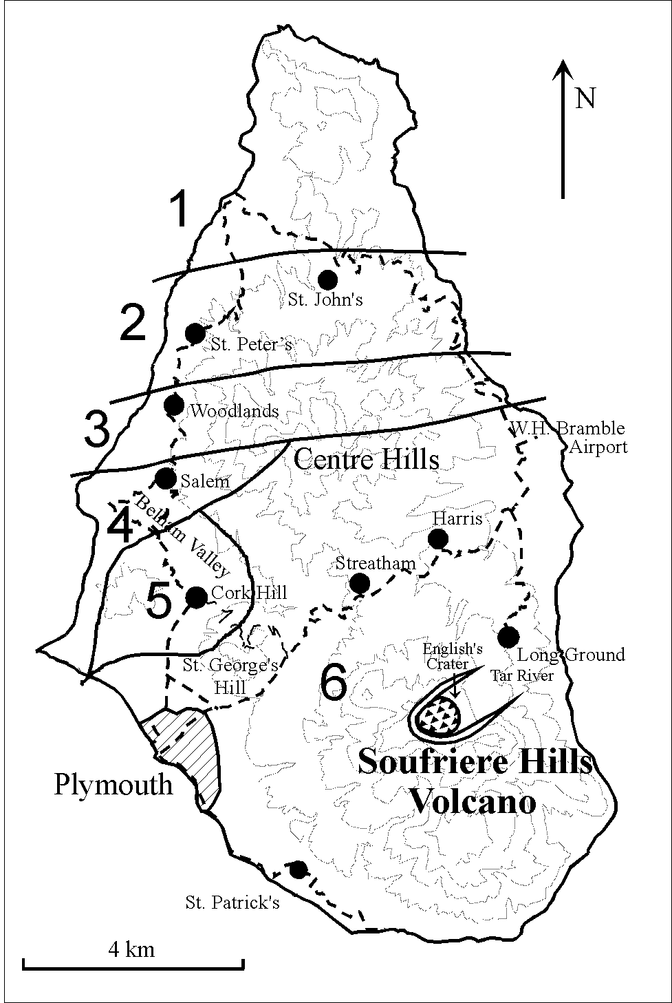
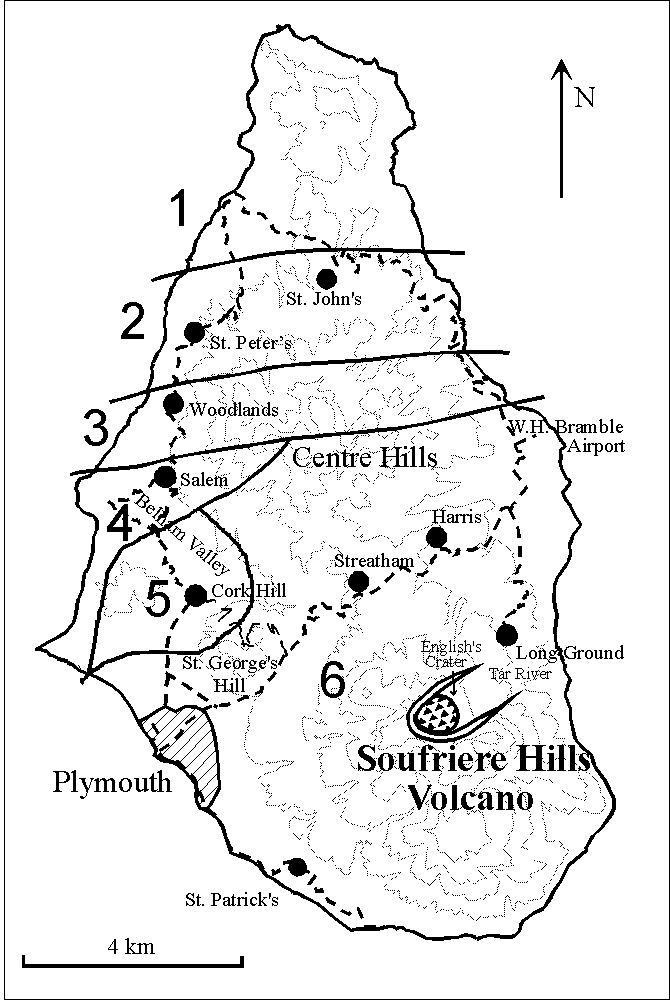
    Figure 1: Key features of Montserrat and population zones (900x635 GIF, 6.5K -- 1225x865 GIF, 10K

  3. The participants at the Antigua meeting could not identify any volcanic crisis where a detailed risk assessment had been previously performed during an eruption. Hazard evaluations including estimates of probabilities have been used by MVO during the crisis to provide information to the civil authorities to guide decision-making.

  4. The elicitation exercise and hazard reports in August/September 1997 raised concerns over the interpretation of the probabilities of casualties being sustained in the north from the two scenarios of a sustained explosive eruption and an explosive surge (see Glossary (Appendix B) and companion report for definitions and further details). In particular, there was doubt amongst decision makers over whether or not the figures meant the north was 'safe'. At this time, Salem was identified as 'unsafe' and full evacuation was recommended. It was also recommended that northward relocation of key infrastructure and group housing be started from the Woodlands/Olveston area (MVO report to GoM, 3 September 1997).

The Concept of Risk

Definitions

  1. Definitions of hazard, risk and vulnerability proposed by UNESCO (Fournier d'Albe 1979; J. Geol. Soc., Vol. 136, p. 321-326) have been used. Risk is defined as the probability of a specified loss, as indicated by the relation risk = value x hazard x vulnerability. Value is the number of lives, property or productive capacity threatened. Hazard is the probability of occurrence of a given area being affected by some harmful or dangerous event within a given period of time, and vulnerability is the proportion of the value likely to be lost in a given hazardous event. Individual risk is the probability level at which an individual may be expected to sustain a given degree of harm from a specific hazard. Societal risk is the probability at which specified numbers of people in a given population, or the population as a whole, sustain a specified level of harm from the realisation of a specified hazard. In general, these latter risks are measured in terms of the chance of the individual's death, and the chance of a number of deaths within a population or group, respectively. Each kind of hazard usually carries an additional risk of injury.

  2. In this study, casualties refers to fatalities or victims with life-threatening injuries. In any of the eruptive scenarios some survivors with severe injuries can be expected, a small proportion in pyroclastic surges and a higher proportion in tephra falls with roof collapse. A more detailed investigation would be needed than was possible here to model survival rates according to each scenario, but it is assumed here that any death/casualty figure greater than 5 would exceed the local emergency response capacity.

Classification of Risk

  1. A classification of levels of individual risk has been published by the UK Chief Medical Officer of England and Wales (CMO) (Appendix C, Table C.1). On the basis of this scheme, a LOW annual risk of death (between 1:10,000 and 1:1,000) might be deemed tolerable to individuals for at least a limited period of time so long as some important benefit was being received and assuming that the risk was being properly controlled, while a MODERATE risk (between 1:1,000 and 1:100) is perhaps only marginally tolerable to most individuals under more exceptional circumstances. A HIGH annual mortality risk (greater than 1:100) appears to go beyond what most individuals would be comfortable with. Most individuals are more prepared to accept voluntary risks than involuntary ones.

  2. For the purposes of communicating risk to decision-makers and to the public on Montserrat, results of the present assessment are expressed in terms of the broad bands within the CMO's scale, rather than placing emphasis on calculated numerical probability values of uncertain precision.

  3. Societal risk is more problematical as there is no clearly-established scale. The probability of a certain number of people being killed is important as a measure of the risk of a major disaster, with all its political implications. Moreover, as an indication of the expected sizes of mass casualty events, it is also essential for emergency medical planning.

Quantitative Risk Assessment

  1. A major objective of the risk assessment is the calculation of the probability of fatality figures resulting from the different types of eruptions that could occur within the next six months. The analysis does not include estimates of injuries (which, for emergency planning purposes, might be inferred from fatality numbers by medical specialists and volcano emergency specialists) or long-term health risks from ash, which are discussed below.

  2. Because many eruptions are short-lived, Quantitative Risk Analysis (QRA) techniques have not been widely used in volcanic hazard mitigation and crisis management. QRA provides a formalised basis for assimilating the many and varied scientific uncertainties which exist in a volcanic eruption. Mitigation in volcanic crises has usually been achieved by evacuation in short order of populations from extended geographical areas; however, the size of Montserrat militates against this approach and something akin to crisis micro-management has developed. Detailed quantification of risks can be used to provide a rational and consistent basis for decision-making.

Approach and Method

  1. The approach has been to assemble all plausible volcanic scenarios for the Soufriere Hills volcano on a logic-tree framework with branching to accommodate a hierarchy of related hazards (Figure 2). A Monte Carlo technique has been used to sample the probability distributions for each branch of the logic-tree and for a variable population distribution.

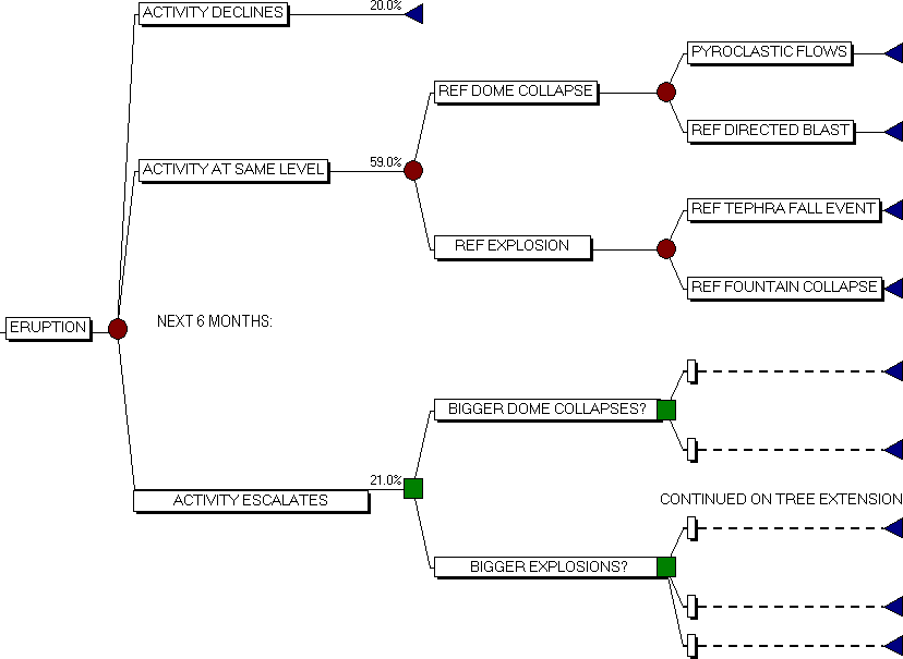
    Figure 2a Logic tree for relationships between future activity, events and hazards. Ranges for the event probabilities not shown are given in Table F.2. (830x605 GIF, 8.2K)

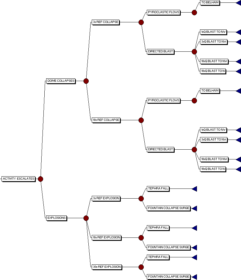
    Figure 2b Continuation of logic tree (above) for scenarios involving an escalation in activity. Ranges for event probabilities are given in Table F.2. (790x915 GIF, 10K)

  2. Particular hazards are modelled by specific scenarios (known as piece-wise parameterisations). Continuous distributions of hazards would be more exhaustive but, considering time restrictions, the procedure used here represents adequately the possible range of levels of activity in increasing impact, from the benign (e.g. a decline in activity) to a maximum plausible magnitude of each type of eruptive event.

  3. The risk analysis is based on the current scientific assessment. If activity escalates to a new peak, an important unexpected event occurs or other significant new information arises (e.g. from monitoring) then the probabilities of hazardous events can change. Regular updates of the risk analysis should therefore be part of the planning process and crisis management.

  4. Uncertainty is accommodated in the analysis as follows. For each initiating volcanic event, the elicited or assessed modal probability of occurrence and the plausible range of probabilities which encompass that best estimate are transformed into a simple Beta probability distribution function (pdf). This form of pdf can represent the central tendency, the extremes and the skewness of the collective scientific view. Conditional probabilities that determine whether the events impact a particular place (e.g. wind direction; blast intensity; preferential collapse direction, etc.) are also represented by Beta pdfs, the parameters of which are determined from elicited or calculated estimates of minimum, mode and maximum values. The product of the probability distribution for the initiating event with the conditional probability distribution(s) defines the likelihood of a hazard happening in a particular place.

  5. In order to take account of the variability of population density, the most recent population count data for Montserrat (reported by GoM in early November 1997) has been used to estimate population aggregates in five broad geographical zones (see Figure 1). According to this count, the present total population of Montserrat is 4089 souls, comprising: 1088 people in population zone 1; 2248 in zone 2; 619 in zone 3; 134 in zone 4; 0 in zone 5. (In partitioning the population into crude geographical subgroups, it may be noted that although some of the population zones are drawn to extend across the whole island, the sub-populations comprising population zones 4 and 3, and to a lesser extent population zone 2, are almost exclusively restricted to western coastal areas).

  6. Next, a view was taken on the impact each volcanic event might have on each affected population. The number of people impacted depends on the spatial extent of pyroclastic flows and surges, tephra and ash falls etc., which in turn depends on the scale of the eruptive events. The distribution of population within each zone has also been taken into account. In the present assessment, this principle has been generalised by the assembled experts by ascribing ranges (to incorporate uncertainties) of population impact factors for each identified population by each event scenario, expressed as impact percentages (which are again turned into equivalent Beta pdfs, as with other variables).

  7. However, in attempting to assess the impact of a specific volcanic hazard on an identified population, a further additional factor has to be introduced to take some account of the vulnerability which may arise from varying circumstances: e.g. daytime or night-time occurrence of the event; any alert or warning lead-time which might be possible (rapidity of event onset, or scientists warning, for instance); proximity to or occupation of houses (especially for tephra fall), etc. These vulnerability factors have been set to range from 1.0 to 0.5, depending upon the scenario in question, where the higher figure indicates that no effective reduction in vulnerability is allowed.

  8. In the case of most hazards it is possible (and generally preferable) to undertake semi-deterministic numerical modelling and a detailed probabilistic assessment of consequences, rather than rely on expert judgement. For example, the transport of clasts and the dangers to the public of bombardment by clasts have been so modelled for the purposes of the present assessment (see Appendices D and E). Numerical models for runout of flowage phenomena are less well constrained at present but may be utilised in future risk assessments.

  9. By Latin hypercube sampling (see Glossary, Appendix B) from these probability distributions, the overall probability of casualty figures can be enumerated in a Monte Carlo simulation of possible loss scenarios. Computer implementation of this simulation has been carried out using the commercial program "@Risk". The numerical error introduced through finite sampling is limited to a few per cent by executing ten thousand iterations per simulation, the undertaking of many more iterations than these being time-consuming without providing any real improvements in the solution.

  10. The robustness of the output from the Monte Carlo simulation is subject to the stability of the input parameterisation. Thus, results for the next period of six months should not automatically be presumed to be extendable to the subsequent six month period. The probability distributions elicited are not necessarily stationary, but could be subject to future amendment if conditions change.

  11. The main numerical inputs to the QRA in terms of volcanic event probabilities and population impact estimates, as determined, assessed or elicited by the scientific group at their meeting, are recorded in Appendix F, along with a detailed description of the methodology of input parameterisation. The causal sequences which form the basis of the QRA are summarised on the logic tree of Figure 2.

Results of the Monte Carlo simulation of casualty rates

  1. Two simulations have been run with alternative upper probability bounds on the tails of the occurrence distributions for each of the initiating events (with unchanged middle and lower values and conditional probabilities). This acts as a test of sensitivity to uncertainty in the upper bounds of the probabilities. The results given in Table 1 for the probability levels for various numbers of casualties are given as spans (except where the answers from the two simulations converge to the same value), and are shown as probability of exceedance curves on Figure 3.

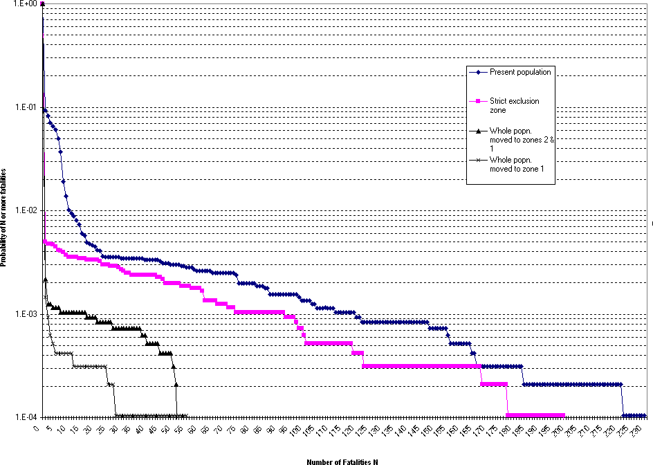
    Figure 3: Cumulative probability for fatalities in the four population scenarios. (945x670 GIF, 12K)

    Table 1 Probability of N or more fatalities (for six months) for different population distributions.
    Population model N = 1 N = 5 N = 10 N = 50
    Current situation 9 - 13% 2.5 - 5% 1.0 - 1.5% 0.3 - 1.0%
    Strict exclusion 0.35 - 0.5% 0.32 - 0.45% 0.26 - 0.35% 0.2%
    North of Lawyer's 0.18 - 0.22% 0.12% 0.10% 0.03%
    All in area 1 0.12 - 0.15% 0.04% 0.04% 0.02%

  2. This analysis indicates that the current situation provides an almost 90% probability of not incurring any new fatalities from eruptive activity on Montserrat in the next six months (see Figure 3). However, there is therefore a one in ten chance of there being less than five fatalities from the activity in that time, if the present population distribution remains unchanged. The exposure could be cut to about 1 in 250 by strictly enforcing the exclusion zone or to 1 in 500 by a more complete relocation to northern Montserrat (north of Lawyer's Mountain). The chances of suffering mass casualties (i.e. 5 or more) for the current situation are 2 to 5 times lower, for a strict exclusion they are very similar and for everyone north of Lawyer's Mountain, odds for mass casualties are about half of those for a single fatality.

  3. The annualised individual risk for the different areas, under the current conditions, are given in Table 2. For an individual in one of the areas north of Lawyer's Mountain, the annualised individual risk for death by eruption is less than one in one hundred thousand, which would be classified as MINIMAL under the CMO's scale. People remaining in Salem full-time are accepting a MODERATE level of personal risk, while allowing residents to return to Richmond Hill/Cork Hill would imply accepting a HIGH risk situation. For each of these cases there is a concomitant risk of injury, which may involve a significantly greater risk exposure in probability terms.

    Table 2 Annualised individual risk of death by volcano in each population area. The CMO's scale is given in Appendix B.
    Individual risk Area 5 Area 4 Area 3 Area 2 Area 1
    Numerical odds 1:100 1:450 1:5,000 1:120,000 1:200,000
    CMO scale HIGH MODERATE LOW MINIMAL MINIMAL

  4. A common way to illustrate societal risk is to show how many people are expected to die at set probability levels. Table 3 shows the numbers of deaths for probability exceedance levels of 1 in 100, 1 in 1,000 and 1 in 10,000.

    Table 3 Approximate number of deaths for given probability exceedance levels.
    Population model 1 in 10,000 1 in 1,000 1 in 100
    Current situation >= 200 >= 120 >= 10
    Strict exclusion >= 180 >= 90 >= 1
    North of Lawyer's >= 50 >= 20 >= 0
    All in area 1 >= 40 >= 1 >= 0

  5. These results are only approximately equivalent, numerically, to the results above (Table 1) because eruption event sizes are piece-wise scaled in the simulation and because, for practical reasons, only a limited number (i.e. 10,000) of re-sampling iterations were used in each Monte Carlo analysis. The latter constraint means that the tails of the various distributions will have received only restricted sampling under the Monte Carlo scheme.

  6. The robustness and conservatism of the QRA results have been provisionally examined by performing repeated simulations (10 in number) using different seeds for the random number generator. These indicate that the presented results for the 'current situation' scenario, as given on Table 1 and Figure 3, are at the conservative end of the spectrum, close to or exceeding the estimated 95%ile level obtained from the 10 repeat runs, for fatality exceedances in the range from N >1 to N >50. The spread of results from these repeat runs is such that differences between the reported results for the four separate population scenarios (again, see Table 1 and Figure 3) are expected to be statistically significant at any rational confidence level, and can therefore be taken as meaningful for comparative purposes.

Qualifications

  1. The present QRA exercise is a preliminary risk assessment of the volcanic activity in Montserrat, using inputs from a single meeting of scientists. Because of time constraints, the opportunity has not existed to report the results back to the same group for appraisal of the volcanological balance of the results, feedback and further iteration of the modelling procedure, such as would normally be done in a risk assessment.

Ranking Hazards and Implications for Risk Mitigation

  1. The hazard scenarios which may have the potential to cause 5 or more fatalities are ranked by their probability of occurrence in Table 4, and discussed in following sections in terms of possible mitigation. Fatality figures refer to the present distribution of the population, and do not include implementation of mitigation measures.

    Table 4 Hazard scenarios with risk of 5 or more casualties in the next six months,
    ranked in probability order and assuming the current population distribution.
    Hazard scenario Approximate
    probability of event
    Expected
    number of
    fatalities
    10 million m3 dome collapse, pfs down Belham 1:10 5
    30 million m3 dome collapse, pfs down Belham 1:125 15
    10 times power ref. explosion - fountain collapse surges 1:500 100
    10 times power ref. explosion - tephra fall in E-W wind 1:1,000 10
    30 times power ref. explosion - fountain collapse surges 1:2,000 190
    100 million m3 dome collapse, pfs down Belham 1:2,000 115
    30 times power ref. explosion - tephra fall in E-W wind 1:3,000 40
    Collapse with 3 times power ref. explosion causing blast to NW 1:4,000 40
    10 times power ref. explosion - tephra fall to N and NW 1:8,500 40
    Collapse with 10 times power ref. explosion causing blast to N 1:10,000 80
    Other collapses followed by lateral blast 1:10,000 to 1:1,000,000 190 plus

  2. If activity continues at about the same level, or escalates slightly, pyroclastic flows from big dome collapses are the hazards which have an elevated likelihood of occurrence (i.e. about 1 in 10 to 1 in 100) compared to other types of activity and could give rise to more than one or two fatalities. Their potential impact area is assessed to be predominantly within population zones 5 and 4, so the southern boundary to population zone 3 defines the extent of this particular danger, and the risk of taking several casualties can be significantly reduced if the present Exclusion Zone is rigorously enforced.

  3. For a significant escalation in activity levels, next in a lower order of likelihood of occurrence (at about 1 in 1,000 to 1 in 10,000 probability), are a number of different scenarios each of which could give rise to multiple casualties under the present population distribution. Those which involve fountain-collapse surges or dome-collapse flows could threaten population zone 3, and the only effective mitigation against these particular hazards would be to significantly reduce the exposed population in population zone 3. In the case of the more extreme surge scenarios, there is only a marginal degree of confidence that all parts of population zone 2 would escape impact, and increasing the margin of safety there could only be achieved by moving people further north within population zone 2 or over into population zone 1. Also in this range of likelihoods of occurrence are heavy tephra falls during a major vertical explosion, and directed blasts and airfall following a big dome collapse; getting people to shelter only in stronger buildings, or taking steps to strengthen weaker structures, would reduce the risk to people of the airfall hazards. Within the hierarchy of reasonably foreseeable hazards, the lowest probability event (i.e. below 1 in 10,000) is a sustained directed blast triggered by large-scale dome collapse. In this circumstance, reduction of risk again implies a requirement to have as many people as possible as far away from the eruptive centre as is achievable (i.e. in population zone 1).

Warnings

  1. Risk can be reduced if the scientists at the MVO are able to anticipate the signs of impending hazardous activity and provide timely warnings that keep the public alert, and result in precautionary evacuation or taking shelter against fallout.

  2. Understanding of the volcano has improved. There has also been retrospective analysis of the larger eruptions, such as the major pyroclastic flows and the explosions, to look for precursors in the monitoring data. The ability of the MVO to anticipate the volcano has consequently improved so that there is an increasing likelihood of being able to give warnings when the volcano moves into a more dangerous state. Close monitoring of the activity has provided abundant information which has allowed significant changes in the volcano to be detected prior to some hazardous events. Changes of state and onset of dangerous eruptions can however be very rapid and the time for warning may be very short (minutes to hours) and the MVO will never be able to guarantee fully the forecasting of dangerous events given the inherent dynamic variability of the volcano and incomplete understanding of the controlling processes. Appendix G provides a more detailed account of the ability to give warnings.

  3. The warning system developed at MVO during the crisis has been a vital component of the risk management system on Montserrat. The state of the volcano is described to the public on a daily basis and changes that might herald more vigorous or hazardous activity are communicated to the civil authorities.

  4. On several occasions it is the volcano that gives the warning with large pyroclastic flows or explosions visible to all. Activity at the volcano, however, has limited effect due to the longevity of the eruption. People become used to the activity and start to accept it. It can also be difficult to persuade people that the volcano is moving into a dangerous state when it has appeared benign for weeks on end.

  5. Set against the improvements in understanding are a number of factors that reduce the ability of the MVO to make warnings. Monitoring has become more difficult and dangerous as the activity has elevated and key sites have been destroyed or have become impossible to access for safety reasons. Maintenance of the monitoring network is increasingly difficult and risky and key parts of the monitoring network are highly vulnerable in times of major volcanic activity. Loss of the tilt-meter close to the volcano, reduction of the sites available for study of ground deformation and difficulties with obtaining data on SO2 flux are examples of recent problems. The MVO is currently addressing these problems, but reduced monitoring capability inherently hinders MVO's ability to provide short-term warning, and counteracts risk reduction measures.

Effectiveness of Warning Communication

  1. Much effort has been expended by MVO in improving the effectiveness of its warnings. Detailed alert systems were in place for much of the eruption and the high profile of MVO has enabled close interaction with the public and with crisis management officials. However, there is some evidence to suggest that warning communication will become more difficult as the crisis continues, due to population fatigue and degradation of some of the infrastructure necessary for implementation. The lack of sirens in the central and northern parts of Montserrat is an example of infrastructure development which has been recommended but not acted upon. Effective short-term warning of the onset of serious eruptive activity would enable the population to take personal action to reduce risk but the concept of false alarms must be highlighted in advance.

Implementation of appropriate action

  1. This is a key element of any discussion of risk reduction. Implementation of measures to reduce risk in the light of warnings must be effective. Appropriate action may be implemented by individuals to reduce their own risk or by relevant authorities to reduce the societal risk. The evidence on Montserrat suggests that reduction of individual risk has been an important driving force for actions following warnings. However, the actions of the authorities to reduce societal risk by zoning have greatly reduced fatalities during the eruption to date.

  2. The events of 25 June 1997 illustrate this point. Interviews with survivors who were within an area which had been declared highly dangerous (the warning) show that the individual's decision was to increase their personal risk for some benefit to themselves. The reduction of societal risk was through declaration of an exclusion zone, which ensured that loss of life was minimal.

  3. Since those events, implementation of action after warnings (on whatever time scale) has become more difficult as the volcano has impacted on wider areas. More and more individuals are affected, and each undertakes a personal risk assessment. In many cases, these assessments may lead to the conclusion that the personal risk is worth taking, given the benefits of continued occupation of homes and land. This means that authorities must take firm action through enforcement of zoning in order to address increasing societal risk.

Mitigation

  1. Mitigation measures are those which reduce risk in the medium to long term through a variety of means including engineered protection, improved warning, public education, land-use planning and effective emergency planning. Mitigation has been implemented to some extent on Montserrat, but there is great potential for improvement of mitigation measures to reduce risk.

Engineered Mitigation

  1. Mitigation from pyroclastic flow and surge phenomena requires highly complex engineered structures such as air-tight underground concrete bunkers, which are clearly impractical as a general solution for Montserrat.

  2. Hazards due to falls of fine ash can be reduced (mitigated) in several ways. Sprinkling of water on main roads during periods of high ash accumulation would curtail the circulation of ash in the atmosphere, and more extensive washing off of ash periodically would increase the effectiveness. Wearing of ash masks in dusty conditions is a very simple and widely used personal mitigation measure and has been the topic of extensive education programmes on Montserrat.

  3. The effects of thick tephra falls on roofs of houses can be mitigated against in a number of ways. Roofs can be strengthened by adding corrugated iron sheeting over existing weaker roofing, and new housing should be built to higher standards. A steep pitch on roofs of any new housing is preferable to avoid ash loading. Adapted steel containers could be placed to act as shelters during tephra fall events. Adjustable wooden or metal props can also be provided to support key structural members of the roofs in vulnerable buildings. Ash can be removed from roofs, although great care is required to avoid the risk of accidents. Ash removal may not be practical in the case of long-duration or heavy fallout.

  4. Infrastructure development can assist in reducing risk by ensuring that zoning is strictly adhered to and by providing benefits to individuals to move out of dangerous areas. Measures such as withdrawal of services can be implemented to ensure enforcement of an Exclusion Zone, and providing housing and facilities away from dangerous areas acts as an incentive for non-occupation of dangerous areas.

Improved Warning

  1. Much of the impact of warning on risk reduction is through communication and implementation. Long-term or short-term warnings based on scientific monitoring can possibly be improved by new technologies etc., but improvements are likely to be small and indeed the current trend has been a reduction in capability due to the increased risk and difficulty of working near the volcano. As stated above, even maintaining monitoring near the current level will require additional equipment and improvement in operations.

  2. Monitoring of feedback from the public to warnings given by scientists and authorities would assist in ensuring the most effective methods of warning were utilised. Such feedback monitoring has not occurred thus far on Montserrat so that the effectiveness of existing warning procedures is largely unknown.

Public Education

  1. A well trained and organised society can significantly reduce individual risk through public education and training. Examples such as air-raid precautions in wartime London and the management of volcanic risk at Sakurajima volcano in Japan illustrate this point. Education for hazard perception is already high on Montserrat, but a culture of civil defence is not well established for the volcanic crisis. Effective use of engineered structures and effective reaction to improved warnings are important in risk reduction. These come about through concerted public education programmes and through the continuing commitment of the authorities.

  2. There is some evidence to suggest that the high level of education for volcanic hazards is now having a negative impact on reducing risk on Montserrat. The perception of the public remaining on Montserrat is that they know a lot about the volcano. This has a tendency to reduce the effectiveness of warnings from MVO unless warning signs from the volcano itself are obvious. As the crisis continues, this effect will increase due to the inherent difficulties in forecasting volcanic activity (the public perception will be that warnings issued by MVO are predictions and that these 'predictions' will more often be wrong than right).

  3. The challenge for public education programs is thus to help the public to understand the problem of so-called "false alarms", and the limitations of forecasting ability of MVO, such that compliance with zoning regulations is seen as the most appropriate way of vulnerability reduction.

Emergency Planning

  1. Effective emergency plans can reduce risk by increasing the value of warnings and public education. Two means of reducing risk of death following the occurrence of a severe event are an effective search and rescue infrastructure and a comprehensive mass casualty plan. Through these two mechanisms, the proportion of deaths resulting from a given number of casualties can be lowered, although the scale of this reduction depends largely on the type of hazard. There are also limits on response capability for a small island.

  2. The types of casualties seen in pyroclastic flows and surges would tax the hospital services of the most advanced countries. Injuries in survivors of pyroclastic surge clouds are mainly 2 and 3 degree burns over large percentages of surface body area, which are often sufficient to cause death; mortality is greatly increased in the presence of inhalation burns, which are common. Impact trauma from flying fragments within the surge clouds may also occur. Even small area burns (e.g. to the feet) can be serious and very deep due to the high temperature of deposits; such burns require urgent and specialised treatment. Experience of the 25 June 1997 event showed that all survivors with burns would need further urgent evaluation and appropriate treatment off-island, though stabilisation of patients in preparation for helicopter evacuation was feasible with the island's hospital facilities.

  3. Scenarios of the larger explosive eruptions with fallout of tephra will carry a risk of trauma from large fragments of pumice unless shelter is obtained before the onset of fallout. Fragments of 10 cm diameter will have sufficient impact energy to cause lacerations and severe, often lethal, head injuries. Impacts of 10 - 20 cm fragments could cause pulmonary contusions, fractured ribs, haemothorax, pneumothorax and even penetration of the chest wall. Impacts to the abdomen could cause internal haemorehage involving the liver, spleen or kidneys. Similar injuries, including fractured limbs, would result from collapses of roofs laden with tephra, as well as asphyxia from burial by tephra.

  4. Treatment for most multiple trauma is not possible with the hospital facilities on Montserrat and severe cases would require urgent surgical intervention to save life. Helicopter evacuation is not so feasible as for burns cases, as transporting patients carries additional risks.

  5. The larger eruptions affecting Woodlands with surges or large-scale tephra fallout would be major incidents for the island and its emergency capabilities. Impacts further north would seriously impede any response capability which was able to continue functioning, and the large-scale events of low probability would be major disasters which could not be adequately responded to even with external assistance. An important factor in the latter would be the inability of naval craft to use the jetty facilities and helicopters could not land if ash remained suspended in the air; and on-island transport could be hindered by thick fallout deposits. A wide margin of safety must therefore be adopted to ensure that the risk of the population encountering any of the impacts of the scenarios shown in Table 4 is reduced to a level that was well within the very limited bounds of practical emergency planning for the island.

  6. The off-island evacuation plan as last seen by the MVO has many flaws and a radical rethink was required for such a plan to impact significantly on reducing risk levels for the population of Montserrat. Views of the MVO scientists on this plan have been given directly to those responsible for planning. Modifications to the plan are now in preparation with the full involvement of the scientists. The existence of such a plan does not, of course, diminish the need for on-island hazard mitigation measures.

Health Effects of Volcanic Ash

  1. The potential risk to health from the fine respirable ash (PM10 or particles less than 10 mm diameter) has been the subject of a number of reports and ongoing investigations. The most recent health risk assessment was summarised in a report by Dr. P.J. Baxter and Prof. A. Seaton to the UK Department of Health on 5 September 1997 (Appendix H). The assessment was incorporated into the advice given by the Chief Medical Officer (England and Wales) which was passed to the Government of Montserrat. There is also an on-going investigation of this issue by the Institute of Occupational Medicine (Edinburgh), the Department of Community Medicine (Cambridge University), the Department of Geology (Bristol University) and the British Geological Survey. This section summarises the key points pertaining to the health risk from volcanic ash.

  2. The respirable ash derived from the pyroclastic flows contains between 10 and 25% cristobalite, a form of silica known to be a cause of silicosis after prolonged periods of exposure. The volcanic ash from explosions on the other hand contains significantly less cristobalite and fewer respirable ash particles.

  3. Air quality is monitored on Montserrat by measurements of the concentration of suspended respirable dust (PM10) and is reported to the public by MVO. Air quality is described in accordance with hourly average bands agreed with the Department of Health (England and Wales).

  4. Exposure to the ash is strongly variable across Montserrat. Prevailing low-level winds (less than 6 km) blow the plumes of fine ash generated by the pyroclastic flows to the west and west-northwest and thus the ash mostly affects communities close to the volcano (areas 4, 5 and 6). Northern Montserrat (areas 1 and 2) has received very little ash, except for a few weeks from 22 September to 21 October 1997 when some of the explosions deposited significant ashfalls under relatively uncommon wind conditions. Area 3 has received moderate amounts of ash, and becomes vulnerable to ashfalls whenever pyroclastic flows run down the northern flanks of the volcano.

  5. Ash exposure also depends on the weather and eruptive behaviour. At present, the volcano is erupting to the south, producing modest amounts of ash which is blown out to sea well away from the populated areas. The rains in the wet season have also removed much of the ash in the currently populated areas and air quality is good. For several months earlier in 1997 the volcano was erupting towards the north and air quality was moderate to poor in area 4 (Salem) with frequent ash falls. Air quality is particularly poor where human activity (e.g. vehicles, sweeping and shopping) re-suspends ash many days or weeks after ash has fallen. Air quality further north (areas 1, 2 and 3) has generally been good and the main ash falls from the recent explosions contain substantially less cristobalite.

  6. Comparison of exposure levels has been made with published studies of the occurrence of silicosis in industrial settings (e.g. workers in mines and quarries). There are no comparable studies of silicosis available in communities exposed to volcanic ash or dusts of similar composition to this eruption and estimates of risk have therefore to be extrapolated from the findings of occupational studies. The available information indicates that if exposure of communities to the measured levels in the strongly impacted areas (area 5 before evacuation and area 4 earlier this year) continued for six or more years then approximately 10% of the population from these areas might be expected to develop fine nodules seen on chest X-rays. In a small proportion of the affected individuals the condition could become progressive and lead to a reduction in lung capacity, with symptoms of breathlessness on exertion, but is unlikely to be severe enough to shorten life. There is a risk that previous pulmonary tuberculosis could be reactivated in some individuals, and most evidence points to silicosis being associated with a small increase in lung cancer risk (very small in relation to cigarette smoking). The fine ash is known to aggravate symptoms in asthma sufferers, such as wheezing and tightness of the chest.

  7. More severe silicosis, leading to impairment of lung capacity, and symptoms of breathlessness, could develop in individuals exposed regularly to substantially higher cristobalite concentrations of around 0.5 mg/m3 over 24 hours in a matter of only 2 - 3 years. This would amount to a high exposure to the ash, but it could occur in some sectors of the population, (e.g. those living and working close to busy roads, outdoor workers and others under conditions of very frequent ashfalls in dry weather). Exposure to the lower concentrations estimated for workers in area 4 and 5 might be anticipated to lead to the same consequences if exposure were to continue for a further 8 - 10 years.

  8. In a small proportion of the population, including children, the consequences of frequent exposure may be less predictable and some could develop enlargement of the hilar glands detectable on chest X-ray after only two or three years, a condition which would lead to a raised susceptibility of developing progressive silicosis on exposure to lower levels of crystalline silica in the future. Children may be more susceptible to the toxic effects of the ash than adults and, like certain outdoor workers, they may also receive much higher exposures than the general population as a result of their activities.

  9. The duration of exposure to the cristobalite in the ash in the strongly impacted communities so far is not regarded as long enough to lead to silicosis and it is very unlikely that anyone would be adversely affected if their exposure to ash were now to cease. The northern part of Montserrat (areas 1 and 2) has not received sufficient ash to be a concern.

  10. Ash has accumulated to depths as much as 20 cm in Cork Hill (area 5) and towards Plymouth. The amount of ash would make it impossible to advise reoccupation of these areas on health grounds until the ash had been removed by natural processes and human activity, and the large deposits of ash on the volcano will also be blown by prevailing winds towards this sector. Exposure levels could therefore remain unacceptable for at least many months after activity declined.

  11. In September 1997, the Chief Medical Officer advised that communities should relocate from areas heavily impacted by ash, at that time Salem and Frith. There is no reason to deviate from this precautionary advice for other areas impacted during future activity of the volcano, but the composition of the respirable fraction of the ash will need to regularly monitored along with ambient air quality to ensure that the health risk to people living on Montserrat is kept as low as is reasonably practicable.

Discussion and Conclusions

  1. Individual risk to members of the population on Montserrat can be compared with the tables presented in Appendix B. Probabilities can be doubled to make them into annualised probabilities, although it should be noted that the risk assessment is only made for the next six months.

  2. The present quantitative risk analysis indicates that the current situation provides an almost 90% probability of not incurring any further fatalities on Montserrat in the next six months. However, there is therefore a one in ten chance of there being some additional fatalities from volcanic activity in that time, if the present population distribution remains unchanged. The exposure could be cut to about 1 in 250 by strictly enforcing the exclusion zone or to 1 in 500 by a more complete relocation to northern Montserrat (north of Lawyer's Mountain). The chances of suffering mass casualties (i.e. 5 or more) are about a factor of 2 lower for the current scenario. The above analysis does not include potential loss of individuals from time to time due to illegal entry within even a strictly enforced exclusion zone.

  3. Individual risk for the different areas, under the current conditions, suggest that for an individual north of Lawyer's Mountain, the annualised individual risk is less than about one in one hundred thousand, which would be classified as MINIMAL under the CMO's scale. People remaining in Salem full-time are accepting a MODERATE level of personal risk, while allowing residents to return to Richmond Hill/Cork Hill would imply accepting a HIGH risk situation. Occupancy of Woodlands carries a LOW risk, which might be deemed tolerable to individuals for at least a limited period of time so long as some important benefit was being received and assuming that the risk was being properly controlled. For each of these cases there is a concomitant risk of harmful injury, which may involve a significantly greater exposure risk in probability terms.

  4. In terms of societal risk, and considering the available medical facilities and the fact that 5 or more casualties would constitute a major disaster situation in Montserrat, the assessed chances at present are about 1 in 20 to 1 in 40 for five or more fatalities in the next six months, but this could be reduced to about 1 in 1,000 by relocation of all population to areas north of Lawyer's Mountain.

  5. There is therefore a range of threats with diminishing probabilities of occurrence over the next six months, against which some steps can be taken to reduce overall exposure risks. While the extent to which such actions should be taken depends on what the authorities regard is a tolerable risk, the implications of the exploratory QRA are clear: under present conditions, the Exclusion Zone line at Nantes River represents a demonstrable boundary for risk of incurring casualties from dome collapse pyroclastic flows, and extending the exclusion line further north to Lawyer's Mountain would decrease risk from fountain-collapse surges and blasts with lower probabilities; for the whole range of volcanic threats, distance from the volcano engenders a significant reduction in risk, such that the present level of risk in the north of the island (i.e. in population zone 1) is probably comparable to, or less than, the risk from other existing natural hazards.

  6. In the Caribbean region, earthquakes are a common natural hazard, and it is estimated that societal risk levels of around 1 in 250 (for hundreds of fatalities) are present in Kingston, Jamaica. The individual risk for someone living in a vulnerable area of Kingston (e.g. on a steep hillside) is estimated to be about 1 in 25,000. The risks from earthquakes in Montserrat are not quite as high as those in Kingston but still represent a significant threat which is tacitly deemed acceptable and are almost certainly higher for people living north of Lawyer's Mountain than the risk from the present volcanic activity.

  7. As far as societal risk is concerned, there is no deducible or commonly applicable upper level of acceptable or tolerable societal risk; variations depend upon judgement involving other factors specific to each case. The UK Health and Safety Executive has indicated that the maximum tolerable frequency for a wide range of disastrous incidents that could occur in the UK chemical and nuclear industries and lead to 100 or more casualties seems to lie below 1 in 10,000. However, estimated probabilities of flooding (the most common natural hazard in the UK) in east London (100 to 1,000 casualties), after the building of the Thames Barrier, are regarded as tolerable at better than 1 in 1,000. The individual risk for people living in the likely area of inundation is less than 1 in a million.

  8. The present QRA exercise is a preliminary risk assessment of the volcanic activity in Montserrat, using inputs from a single meeting of scientists. Because of time constraints, the opportunity has not existed to report the results back to the same group for appraisal of the volcanological balance of the results, feedback and further iteration of the modelling procedure, such as would normally be done in a risk assessment. However, we consider it provides a rational and sufficiently robust quantitative basis for informing the decision-making process at the present time.

  9. The inherent uncertainties over the activity of the volcano and the potential impacts of its hazardous phenomena should be considered when comparisons are made with more familiar or better-known natural hazards. A margin of safety should be included to allow for these uncertainties in any decision-making process.

  10. This assessment is made only for the next six months and a re-assessment will be required either in six months time or if the volcano shows activity outside of its historical precedent.

Addendum: Error Analysis for QRA

Dr W P Aspinall, 16 February 1998

The conclusions of the preliminary QRA rely on fatality probability-of-exceedance curves for a single set of simulations for four population scenarios (Tables 1 & 3, Fig. 3). Each simulation uses a generated sequence of random numbers to perform Monte Carlo re-sampling. The stability of the results of a particular scenario can be estimated by multiply repeating the simulation using different sequences of random numbers. In the case of the "Present population" distribution (see Fig. 3), an additional 10 simulations have been run, varying only the seed number for the random number generator: the outcomes are summarised on the accompanying figure (Figure Addendum-1)by their average, and 5%ile and 95%ile spreads.

Figure Addendum-1. (925x680 GIF, 17K)

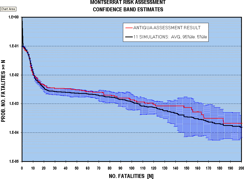
These curves indicate that uncertainty on the probability-of-exceedance values increases at low probabilities, such that the expected exceedance number of fatalities at the 1 in 1,000 level would be no less than 90, and may be high as 165 (cf. Table 3). The lower bound on this curve would just overlap the upper bound on a similar family of curves for the next scenario ("Strict exclusion zone", Fig. 3), making the difference in average values marginal in strict statistical terms (depending on the significance level chosen), but could not be intersected by the bound on the third scenario ("Pop. to zones 2 & 1"). This confirms that the differences in the scenario simulation results presented on Fig. 3 are meaningful, and that substantial reductions in risk could be achieved by moving the population progressively further north, as concluded.

The original single simulation result obtained from the preliminary QRA for the "Present population" scenario is also plotted on the accompanying figure, for comparative purposes. This curve can be seen to fall generally on the high side of average behaviour, near the 84%ile of the spread and, as an expression of the estimated risk, is therefore suitably conservative.

Appendix A: Hazard Report - Executive Summary

  1. The eruption of the Soufriere Hills volcano, Montserrat has continued for over two and a half years. A large volume of lava has been extruded, forming a sequence of summit domes. Activity has slowly increased in vigour and has been at its highest levels over the last six months. The scale of the eruption combined with the small size of the island and the desire to maintain a population presents unprecedented challenges for volcanological monitoring and risk assessment. Compared with other volcanic crises, there is reduced scope for including broad safety margins in delineating areas of different degrees of hazard.

  2. The principal hazards are pyroclastic flows, and fragments of volcanic rock ejected by explosions. Pyroclastic flows are avalanches of hot lava fragments and volcanic ash which can move at speeds of over 100 kph and are highly destructive and invariably fatal to people in their path. Explosions cause rock fragments to be dispersed around the volcano and can cause damage to property and injury to people.

  3. Fine respirable volcanic ash poses a potential long-term health hazard wherever large amounts of volcanic ash accumulates. The ash contains a component of toxic silica known as cristobalite. The geographical distribution of cristobalite-rich ash is not uniform because of prevailing wind directions and volcanic factors. The north of the island has very much lower exposure to fine ash than communities closer to the volcano.

  4. The most likely outcome of the present crisis is that the eruption will progress at levels of activity comparable to those observed so far. This scenario allows for some further modest increases in activity which, if not exceeded, would pose no additional significant safety problems for those living outside the current official exclusion zone north of the Nantes River. This assessment is based on improved understanding of the dynamics of the volcano through the monitoring programme; current understanding of the geological history of this volcano; and comparison with other volcanoes, particularly in the Caribbean. The eruption has not yet stepped beyond the boundaries indicated by the recent geological record of past eruptions of the Soufriere Hills volcano.

  5. The outlook is that the eruption will continue for at least several more months and more likely a few more years. Continuation for more than 15-20 years is considered unlikely. This suggests that scientific input to planning for the island might recognise two stages: one relating to the period while the volcano is active and the second relating to the period when activity is either clearly in decline or stops. It is not feasible to place specific time constraints on the active period and it could take up to a year after the cessation of manifest activity for scientists to feel assured that the eruption had finished. The volcano will then need to be monitored closely for the foreseeable future in order to detect signs of reawakening and to identify hazards that can occur after the eruption.

  6. Larger magnitude and more hazardous eruptive events are possible that would widen the areas affected. The area north of Nantes River through to Woodlands could be affected by such more powerful eruptions, although their probability is believed to be low.

  7. An important issue is the occurrence of eruptions that are sufficiently large that they could affect the north of Montserrat. While this possibility exists, the likelihood is very low and should be viewed in the context of other natural hazards to which the island is continuously exposed. For example, in terms of annual probabilities of occurrence, the chance of such a large magnitude eruptive event during the next six months is probably less than that of Montserrat being struck by a devastating major regional earthquake in the same period.

Appendix B: Glossary of Terms

Fountain collapse: A process by which a violent explosion does not produce a vertical eruption column but instead feeds pyroclastic surges.

Latin hypercube sampling: This is a distribution sampling technique known as "stratified sampling without replacement" [Iman R.L., Davenport J.M. and Ziegler D.K., 1980. Latin Hypercube Sampling (a program user's guide). Technical Report Sand79 - 1473, Sandia Laboratories, Albuquerque, NM]. In tests, it can be shown to consistently produce values for the statistics of an input distribution which are closer to the theoretical values than those produced by random Monte Carlo sampling. It does this by stratifying the input distribution into intervals of equal probability and then making sure each interval is selected so that the overall distribution is uniformly sampled across its full range. These intervals get progressively wider in the tails of a distribution where the probability density drops away. With true random Monte Carlo sampling, the tails of the distribution may be inadequately sampled for defining its true shape, with possible un-conservatism for low probability events in a risk assessment.

Lava: Once magma gets to earth's surface and extrudes it can be called lava. Below ground it is always called magma. A lava dome forms when lava is too viscous to flow easily away from the vent. As the lava dome grows, it becomes unstable (like a pile of sand), and may collapse (hence dome collapse).

Magma: The material that erupts in a volcano is known as magma. It is not simply a liquid, but a mixture of liquid, crystals and volcanic gases. Magma must contain enough liquid to be able to flow upwards to the surface.

Pumice: Pumice is bubbly frozen magma. Fragments of pumice are common on Montserrat and are essentially frothy light rock with a density similar to water (about 1 g/cc).

Pyroclastic flow: These are the most serious hazardous phenomena so far encountered. Pyroclastic flows have been formed both by avalanches from the dome and explosions. The flows consist of three parts. First the main avalanche of hot boulders and ash is confined to valleys and totally destroys most structures and kills people. Second the flows are forced to mix with air as they move and thus form an expanded turbulent hot cloud of ash and air above the main avalanche. These clouds are usually lethal to most people caught in them (typical mortality rates of 90%). They can move at hurricane speeds (about 100 kph), have measured temperatures of 150 to 250°C and badly damage most buildings. People that survive suffer severe burns. The clouds are up to 200 m high and so can spill out of valleys and more energetic clouds can move uphill. Third a pyroclastic flow forms buoyant plumes of very fine ash and hot air that rise above the flows to heights typically between 1 and 6 km. The ash plumes drift in the wind to deposit fine layers of ash.

Pyroclastic surge: These are a flowing mixture of turbulent hot gas with suspended volcanic ash. They form by particularly intense volcanic explosions that cause the hot mixture to move at speeds of up to 400 kph. Large pyroclastic surges are relatively rare and their causes are unfortunately rather poorly understood. They are exceptionally destructive and far less constrained by topography than normal kinds of pyroclastic flow. Large magnitude surge eruptions that have occurred on other volcanoes (e.g. Mont Pelee on Martinique, 1902 and Mount Lamington in Papua New Guinea, 1951) can cover large areas and the more extreme events of this kind are known to have surmounted topographic barriers as high as the Centre Hills (Figure 1). The deposits from these events are thin and are easily eroded, making it hard to prove that such events have never happened at the Soufriere Hills volcano.

Tephra: A general term for all fragmented volcanic materials, including blocks of rock, pumice and volcanic ash. Fallout of tephra from eruption columns and clouds may be called airfall, ash fall or tephra fall.

Volcanic ash: Ash particles are defined as less than 4 millimetres in diameter. Respirable ash consists of particles less than 10 microns (a micron is one thousandth of a millimetre) in diameter.

Appendix C: Risk Comparison Tables

Table C.1 Chief Medical Officer's Risk Scale

Negligible: an adverse event occurring at a frequency below one per million. This would be of little concern for ordinary living if the issue was an environmental one, or the consequence of a health care intervention. It should be noted, however, that this does not mean that the event is not important - it almost certainly will be to the individual - nor that it is not possible to reduce the risk even further. Other words which can be used in this context are 'remote' or 'insignificant'. If the word 'safe' is to be used it must be seen to mean negligible, but should not import no, or zero, risk.

Minimal: a risk of an adverse event occurring in the range of between one in a million and one in 100,000, and that the conduct of normal life is not generally affected as long as reasonable precautions are taken. The possibility of a risk is thus clearly noted and could be described as 'acceptable' or 'very small'. But what is acceptable to one individual may not be to another.

Very low: a risk of between one in 100,000 and one in 10,000, and thus begins to describe an event, or a consequence of a health care procedure, occurring more frequently.

Low: a risk of between one in 10,000 and one in 1,000. Once again this would fit into many clinical procedures and environmental hazards. Other words which might be used include 'reasonable', 'tolerable' and 'small'. Many risks fall into this very broad category.

Moderate: a risk of between one in 1,000 and one in 100. It would cover a wide range of procedures, treatment and environmental events.

High: fairly regular events that would occur at a rate greater than one in 100. They may also be described as 'frequent', 'significant' or 'serious'. It may be appropriate further to subdivide this category.

Unknown: when the level of risk is unknown or unquantifiable. This is not uncommon in the early stages of an environmental concern or the beginning of a newly recognised disease process (such as the beginning of the HIV epidemic).

Reference: On the State of Public Health: the Annual Report of the Chief Medical Officer of the Department of Health for the Year 1995. London: HMSO, 1996.

Table C.2 Risk of an individual dying (D) in any one year or developing an adverse response (A)
Term used Risk estimate Example
High Greater than 1:100 A. Transmission to susceptible household contacts of measles and chickenpox5 1:1-1:2
A. Transmission of HIV from mother to child (Europe)2 1:6
A. Gastro-intestinal effects of antibiotics4 1:10-1:20
Moderate Between 1:100-1:1,000 D. Smoking 10 cigarettes per day1 1:200
D. All natural causes, age 40 years1 1:850
Low Between 1:1,000-1:10,000 D. All kinds of violence and poisoning1 1:3,300
D. Influenza3 1:5,000
D. Accident by road1 1:8,000
Very low Between 1:10,000-1:100,000 D. Leukaemia1 1:12,000
D. Playing soccer1 1:25,000
D. Accident at home1 1:26,000
D. Accident at work1 1:43,000
D. Homicide1 1:100,000
Minimal Between 1:100,000-1:1,000,000 D. Accident on railway1 1:500,000
A. Vaccination-associated polio3 1:1,000,000
Negligible Less than 1:1,000,000 D. Hit by lightning1 1:10,000,000
D. Release of radiation by nuclear power station1 1:10,000,000
References

  1. The BMA guide to living with risk. Penguin Books, 1990
  2. Peckham C. and Gibb D. N. Engl. J. Med. 1995, Vol. 333, p. 298-302
  3. Immunisation against infectious disease. HMSO, 1992
  4. Neu et al. J Chemotherapy 1993, Vol. 5: p. 67-93
  5. Harrison's Principles of Internal Medicine, 9th edn., 1975

Table C.3 Community risk scale
Risk Risk magnitude Risk description:
(unit in which one
adverse event would
be expected)
Example (based on
No. of deaths
in Britain per year)
1 in 1 10 Person
1 in 10 9 Family
1 in 100 8 Street Any cause
1 in 1,000 7 Village Any cause, age 40
1 in 10,000 6 Small town Road accident
1 in 100,000 5 Large town Murder
1 in 1,000,000 4 City Oral contraceptives
1 in 10,000,000 3 Province or country Lightning
1 in 100,000,000 2 Large country Measles
1 in 1,000,000,000 1 Continent
1 in 10,000,000,000 0 World
Reference: B. Med. J., 1997; Vol. 315. P. 939-942

Appendix D: Volcanological Input to Airfall Tephra Risk Assessment

The scientific aspects of modelling the tephra fall have been outlined in Appendix E.3 of the Hazards report. Models of tephra fall were developed for sustained explosive eruptions that are 3 times, 10 times and 30 times the intensity of the reference explosive eruption of 17 September 1996. It is assumed that increase in the intensity by a factor X corresponds to an increase in the magnitude of the eruption by a factor 2.5X. Model isopach (tephra thickness) and isopleth (maximum fragment size) maps were prepared for a small number of critical scenarios involving different assumptions about the wind speed and direction. The same principles could be applied to large numbers of permutations using a computer, but this option was not available to us in the short time given for the study. Such an investigation will require many months of work. The scenarios were selected for average meteorological conditions in the Caribbean and for conditions of a wind with the average regional wind velocity blowing to the northwest, which would maximise the impact on the currently populated areas. The probabilities of events which would maximise impact are much less than the event itself, because regional data over the last 14 years implies that winds blowing to the north-west or north only occur about 10% of the year. We note that winds here refer to those between 6 and 18 km altitude.

Preliminary inspection of the 3 times case indicated that even with unusual and disadvantageous wind conditions such an eruption would not have serious impact on the populated areas and so the study focussed on the larger events.

The combined isopach and isopleth map for each scenario was placed over the map of Montserrat and the thickness and proportions of 10 and 20 cm pumice fragments of density 1,000 kg/m3 were estimated at the main population centre in each of the population areas. Thickness estimates were given a formal error of 20%, based on comparisons of the models with real examples where the column height (proportional to intensity to about the 1/4 power) and wind conditions are known. The number of large clasts falling per unit area per unit time was estimated. 10 cm diameter pumice clasts were chosen because they are large enough to cause injury and 20 cm diameter clasts were chosen because they are certain to penetrate most roofs. The estimates of rates of large clast fall out are estimated on a limited data base as we know of only two studies where the proportions of large clasts in tephra deposits have been estimated. These studies suggest that the isopleth contours, commonly constructed as a measure of the range of large fragments, represent the one percentile of the distribution of all clasts depositing at a site. The uncertainty in this estimate is high and is given a formal value of 50%.

Only three scenarios were investigated in detail. In Scenario I a 10 times eruption occurs in a direction of 280° (the mean wind direction in the Caribbean in the 6 to 18 km range) and the mean wind velocity. In Scenario II the same eruption occurs with wind blowing to the northwest at the mean wind velocity. This event has an estimated probability of over 1 in 8,500, but the impact of such an event would be maximised. Variations of wind speed have the following qualitative effects. Wind speeds well below average would not have as great an impact, because more of the tephra would fall outside the populated areas closer to the volcano. Increasing the wind speed well above average would increase the impacted areas, but would produce slightly thinner deposits and would be a less probable event. In Scenario III a 30 times intensity eruption occurs under the average wind conditions. Wind conditions in such a very powerful eruption are less important, because the ejecta are spread significantly both cross-wind and upwind.

Effects are marginally greater than this scenario if the wind blows to the north at speeds greater than the average, but high altitude winds blow to the north much less than 10% of the year so the probability of both the event itself and adverse meteorological conditions is very low (over 1 in 50,000). Winds above 18 km predominantly blow to the east for much of the year. The eruption column for such an event is estimated at 34 km so the higher level winds will tend to further reduce the likelihood of the worst case.

Qualitatively the results indicate that the 3 times intensity eruption should not be a serious problem. People in all population areas would be advised to wear helmets and go indoors, but there appears little danger of roof collapse except in area 5 which is currently evacuated. The 10 times eruption would not pose problems for roof penetration by projectiles except in area 5 and large clast fall out is not considered a serious threat provided people go indoors promptly and wear protective head gear. The casualty figures for this scenario analysed by Mr. A. Pomonis thus largely relate to roof collapse. Scenario II has more impact than scenario I because the tephra fall is focused over the populated areas. The 30 times event will certainly create serious problems in areas 3, 4 and 5 and will impact areas 1 and 2 more marginally.

Appendix E: Engineering Input to Airfall Tephra Risk Assessment

This appendix is forthcoming.

Appendix F: Input Parameters for Monte Carlo Simulation

Input parameters for all hazard scenarios follow a similar pattern in terms of construction of the Monte Carlo event probability trees used for this risk assessment. Initiating event probabilities are taken directly from the companion report on volcanic hazards, with various conditional probabilities on different hazardous phenomena being produced for certain of these events. Except in the case of airfall tephra hazards, percentage impact on each of the population areas has been estimated by a working group for every scenario. These estimates for flow hazards take into account local topography and distribution of population within the zone. It was felt that this approach was superior to any more formal modelling approach, although models were used to assist in determining general areas of impact for flow hazards. For each event scenario, a further estimate is include of a population vulnerability factor which accounts for limited protection which might be gained from buildings etc. The vulnerability factor could be reduced by mitigation measures (see below).

For the tephra fall hazards, a more numerical approach has been adopted for assessing percentage impact on each of the population areas. Estimates of clast sizes and accumulation rates of tephra from numerical models have been used in conjunction with studies of roof resistance to both loading of material and clast impacts. The number of roof collapses can then be calculated based on a knowledge of building stock distribution for each area, and casualty rates then estimated. Further information is given in Appendices D and E. A constant vulnerability factor and fatalities factor have been used for all airfall hazard scenarios.

As discussed above, the present population distribution is represented by five population zones, each with a local total count. To test the dependence of population risk exposure on location relative to the volcano, and to investigate the effects of extending (or reducing) the size of the exclusion zone, three additional variations have been devised. The four configurations have been used in the simulation to highlight the benefits of movement of the population into areas of lower risk. Population model 1 is for the current situation, model 2 for a strictly enforced exclusion zone, model 3 for a strict exclusion zone extended to include Woodlands and model 4 for the entire population within area 1. Population distribution in these models is given in Table 1; data are the most current available from GoM (early November 1997).

Table F.1 Population distribution for four models as used in the risk assessment.
Population model Area 5 Area 4 Area 3 Area 2 Area 1
Current situation 0 134 619 2248 1088
Strict exclusion 0 0 664 2288 1137
North of Lawyer's 0 0 0 2622 1467
All in area 1 0 0 0 0 4089

Table F.2 gives the actual probabilities and factors used in the Monte Carlo simulation, with uncertainty ranges where appropriate.

IMAGE IMAGE IMAGE

Appendix G: Ability to Give Warnings

The Soufriere Hills volcano has continued to erupt for two and a half years and the MVO scientists are learning some of the empirical rules that govern its behaviour. The reasons for particular kinds of behaviour pattern are not fully understood so it is often a matter of recognising sequences of events or styles of behaviour that lead into the larger and more hazardous eruptions. It would be exaggerating to describe this as prediction, but rather a process of recognising features in the volcano's activity which can lead to more dangerous eruptions and thus being more alert to the dangers during these periods.

Major pyroclastic flows by dome collapse are generally preceded by growth of the dome into an unstable configuration. As the dome grows larger and taller in general the greater the chance that that a large-scale collapse will occur. On several occasions, including before the 25 June 1997 eruption, the dome has grown over one of the flanks and a large collapse has been anticipated several days or weeks before it happened. Some large collapses have also been preceded by significant changes in ground deformation patterns and earthquake activity. There was for example a major and abrupt change in tilt behaviour coupled with reinvigorated earthquake activity four days before the major collapse of the dome on 25 June. A similar change occurred before the major late July pyroclastic flows and explosive activity in early August. Earlier changes deeper in the plumbing system were indicated by significant changes in wide-area ground deformation during mid-March 1997.

All major periods of explosive activity have occurred following major dome collapses, so the chances of explosive volcanism a few hours or days after a major collapse period are much increased. The dome grows in pulses with the locus of dome growth remaining stable and generating rock falls and pyroclastic flows in particular sectors. After several days or weeks in a stable configuration the dome can switch to a new place. There are often premonitory signs of a switch, such as renewed fumarolic activity and changes in earthquake patterns. Once the switch has happened then the chances of, for example, pyroclastic flows threatening particular places, changes. For example the dome is currently (12 December 1997) growing in the south-west sector and pyroclastic flows are going down the White River valley. The threat to area 4 and the Belham Valley is thus currently reduced.

MVO has recognised remarkable cyclic patterns of ground tilt and earthquake swarms which are intimately related to dome growth activity. Cycles range from a few hours to a few days with periods of 6 to 14 hours being most common. Inflation of the volcano is accompanied by shallow earthquake swarms and reduced or no dome growth. Deflations coincide with one or more of the following phenomena: reduced earthquake activity or aseismic periods, invigorated dome growth, pyroclastic flow production, episodes of vigorous gas production and explosions. The cycles can be quite regular so that periods of reduced and enhanced danger can be recognised. The patterns, however, eventually break down after a few days or weeks so the forecasting ability that the pattern recognition provides cannot be extended far into the future.

Longer term changes that might lead into far more serious activity are more difficult to identify. There is a general view amongst the scientists that major eruptions (that is much larger than hitherto seen) would require a significant change in eruptive pattern and would likely be detected by monitoring, with ground deformation likely to play a key role.

Appendix H: Report on Long-Term Health Impacts of Volcanic Ash

Health risk assessment of exposure to ash emissions from the Soufriere Hills volcano, Montserrat

Dr Peter J. Baxter MD FRCP, University of Cambridge and Prof. Anthony Seaton CBE MD FRCP, University of Aberdeen

5 September 1997

1. Exposure assessment

1.1 This health risk assessment is based on the results of the surveys of exposure to volcanic ash made by the Institute of Occupational Medicine, Edinburgh, in September 1996 and June 1997. The surveys were undertaken as part of an evaluation of the risk of silicosis in the communities exposed to ashfalls. Laboratory tests suggest that the respirable fraction of the ash in the air (PM10) contains 10 to 20% cristobalite, a form of crystalline silica, which is considered to be more toxic to the lungs than quartz.

1.2 Ashfalls have impacted on inhabited areas west of the volcano as a result of pyroclastic flow activity that began in April 1996. In subsequent months ashfalls became more frequent as the volcanic activity increased, culminating in the eruption on 18 September, 1996 when there was the heaviest ashfall on the evacuated capital, Plymouth. For the next few months ashfalls in Cork Hill and the Salem area including Frith and Old Towne were intermittent, but they built up again as the dome building and pyroclastic flow activity increased until the largest event so far occurred on 25 June 1997, when a moderate ashfall occurred in the same communities. Since then, the filling of the ghauts on the northern flanks with pyroclastic deposits and ash has meant that, even without pyroclastic flows coursing down the northern or eastern flanks, the winds are more likely to blow clouds of ash re-suspended from the deposits towards the Cork Hill and Salem areas. With the growing threat of death and injury from volcanic activity, Cork Hill was evacuated on 27 June 1997 and the central area, including Salem, Frith and Old Towne, was relocated on 16 August 1997. The north of the island has so far escaped significant ashfalls.

2. Summary of silicosis risk

2.1 The average levels of respirable ash, and hence cristobalite, measured in the ambient air are comparable to exposure levels in metal mines where workers have developed silicosis from inhaling crystalline silica and are therefore of concern. The 24-hour exposure levels in the affected communities regularly exceed the equivalent occupational standard for cristobalite adopted in the United States.

2.2 The human lung is able to remove inhaled dust, and adequate amounts of silica have to build up before the disease process known as silicosis starts. In the circumstances found in most mines, this takes several decades of exposure on a regular basis. This process may be accelerated if individuals are exposed to particularly high concentrations or if the silica is in an especially toxic form, and in these circumstances the disease may take an aggressive and fatal form. The circumstances pertaining to Montserrat suggests that those exposed will come into the former category and their lungs will be in the process of retaining some of the inhaled silica. The toxicity of this silica has not yet been established. Cristobalite is probably more toxic than quartz, but the toxicity of crystalline silica in general varies and is very dependent upon the surface activity of the crystal. This is affected by other minerals. particularly silicates, present in the dust and it may be wrong to assume that exposure to a given concentration of cristobalite is the same when the mineral is alone as when it forms only 10-20% of the inhaled dust. In the latter circumstance it would be very likely to be less toxic.

2.3 The duration of exposure to the cristobalite in the ash at these levels in the impacted communities has not been long enough to lead to the development of silicosis, and it is very unlikely that anyone would be adversely affected if their exposure to ash were now to cease.

2.4 If exposure to the measured levels continued for approximately six or more years, silicosis in the form of fine nodules seen on chest x-ray could develop in approximately 10% of the population. In a small proportion of these individuals, the condition may become progressive and lead to a reduction in lung capacity, but it is unlikely to be fatal. There is a risk that previous pulmonary tuberculosis could be reactivated in some individuals, and most evidence points to silicosis being associated with a small increase in lung cancer risk (very small in relation to cigarette smoking).

2.5 More severe silicosis, leading to impairment of lung capacity and symptoms of breathlessness, could develop in individuals exposed regularly to cristobalite concentrations of around 0.5 mg/m3 over 24 hours in a matter of only 2 to 3 years. Exposure to the lower concentrations (c. 0.1 mg/m3) estimated for workers in the central area might be anticipated to lead to the same consequences if exposure were to continue for a further 8 to 10 years. This assumes that cristobalite is twice as toxic as quartz and that 10 to 20% cristobalite in a mixed dust is as toxic as pure cristobalite at the same concentration. In the longer term some subjects who developed severe silicosis could die as a consequence.

2.6 In a small proportion of the population, including children, the consequences of frequent, high exposures may be less predictable and some could develop enlargement of the hilar glands detectable on chest X-ray after only two or three years, a condition which would lead to a raised susceptibility of developing progressive silicosis on exposure to lower levels of crystalline silica in the future.

3. Recommendations

3.1 As it is impossible to ensure that exposures to ash can be maintained at acceptably safe levels to protect against the development of silicosis in the general population, as well as the majority of outdoor workers, people should be advised to relocate in the event of heavy ashfalls and if there is no immediate expectation of a decline in volcanic activity.

3.2 Families with young children should be especially advised to relocate from areas impacted by ashfalls

3.3 Ashfall on the northern parts of the island have been too light, or the deposits have been too short lived, to pose a silicosis risk to the communities there. The probability of the north being impacted by ash has been low, but it is likely to increase with new and more vigorous pulsations of the volcano.

3.4 Measures such as advising the population to wear masks when exposed to dusty conditions, avoiding work such as shovelling ash off roofs or cutting ash-coated grass, and staying indoors during periods of heavy re-suspension of ash, are either being widely ignored or are impracticable. Exposures in young children are especially difficult, if not impossible, to control.

3.5 The Montserrat Volcano Observatory (MVO) is equipped with a DustTrak instrument which would enable the scientists to quickly evaluate conditions in future ashfalls by measuring PM10. Guideline levels of PM10 would be 1 mg/m3 (short term = days) and 0.3 mg/m3 (long term = weeks); above these levels temporary relocation would need to be considered as a precautionary measure. Elevated levels of PM10 will also exacerbate symptoms in asthma sufferers and others with chronic lung disorders.

3.6 At least weekly DustTrak measurements should be made by the MVO at representative sites in inhabited areas in an air monitoring regime. The frequency of monitoring will need to be increased during periods of deteriorating air quality due to the ash.

3.7 This health risk assessment will need to be reviewed when the results of toxicological tests on the ash are completed by the Institute of Occupational Medicine, Edinburgh, in the next few months.

Appendix I: Discussion of 'Hazard' and 'Risk'

Definitions of hazard, risk and vulnerability, proposed by UNESCO (Fournier d'Albe, 1979: J. Geol. Soc., Vol. 136, pp321-326) have been used previously elsewhere in assessing and stating potential detrimental consequences of volcanic activity. Under that scheme, Risk is defined as the probability or likelihood of incurring a specified loss or injury within a specified time period or in specified circumstances. It comprises three components, indicated by the equation risk - hazard x value x vulnerability. Value, for example, might be number of lives, value of property or loss of productive capacity threatened. Hazard is defined as the probability of occurrence of a given area or location being affected by some harmful or dangerous event within a given period of time, and vulnerability is the proportion of the value likely to be lost in a given hazardous event.

Individual risk is the probability level (or chance odds) at which a particular individual (or perhaps a family unit) may be expected to sustain a given degree of harm from the occurrence of a specified hazard. For the individual person, the important question is "What is the risk to me (or to my family)?" This question forms the main part of a basis for his personal decision-making, the principal balancing consideration being the perceived benefit obtained from ignoring the risk, which again is specific to that individual (or family unit). Ideally, in attempting to quantify individual risk, for whatever purpose, account should be taken of the particular circumstances, pattern of life and other factors which may affect his (or their) exposure. The perception of risk by the individual introduces another important judgemental factor which is the degree to which the particular risk exposure is voluntary (as in pursuing dangerous sports) and to what extent it is involuntary (e.g. living near a petro-chemical plant) - at similar probability levels of exposure, this distinction can give rise to very different degrees of risk tolerance or aversion. The purpose of calculating a generalised estimate of individual risk is to be able to say things like "a person who lives at such and such a location and follows a particular pattern of life has a chance of x per annum of being killed by a given volcanic hazard", so that x in this case can be considered in relation to other comparable types of risk exposure (see, for instance, Table C.2 in Appendix C). In principle, the individual can then make an informed choice on the issues, maximising his own personal interest. This sort of assessment might be helpful, for instance, in circumstances when the risk is deemed to be of only marginal concern officially, and the position of the relevant authorities is one of precautionary advice (as in FCO advisories concerning travel to potentially hazardous locations), rather than mandatory action.

On the other hand, the consequences of a major public disaster go much wider than injury to particular people, and large numbers of individual accidental deaths (e.g. in road accidents) are commonly taken much less seriously by society at large than a single-event killing many people all at once. Any large-scale disaster raises questions of responsibility for public safety and, increasingly, criminal accountability, in ways that accidents to individuals do not. This introduces the concept of societal risk, which can be quantified by the chance (or probability) of specified (large) numbers of people in a given population (or the population as a whole), sustaining a specified level of harm in a single incident or closely-linked sequence of incidents. It is necessary to be armed with some quantified measure of societal risk of this sort, so that political decisions can then be made to accept, tolerate or reduce exposure for the benefit and future well-being of the population as a whole, and so that judgements can be made on mitigation steps, disaster relief and medical response capabilities, and so on. What constitutes a large-scale disaster is a function of the size of the population involved, its ability to cope with the effects and, to some extent, a matter of cultural perception. In the case of Montserrat, just a handful of simultaneous casualties from volcanic action would be likely to overwhelm available medical resources and, in a total population of only a few thousand, number of fatalities at this level would constitute a severe societal trauma (c.f. Table C.3 in Appendix C for a comparative scale of community risk probabilities). It is for all these reasons that quantitative estimates of both individual and societal risk are required for decision-making, planning and mitigation purposes in respect of the present volcanic activity and its potential impact on the people who live on Montserrat.

WHAT ABOUT TABLE F.2

Table F.2 Initiating event, consequent hazard, population impact and vulnerability factors for risk assessment. Note: values in [x,x,x] indicate min, mode and max values.


Montserrat Volcano Observatory