| Michigan Tech Home | Department of Geological Engineering & Sciences | Remote Sensing Institute | MTU Volcanoes Page | Volcanic Clouds Web Site | Total Ozone Mapping Spectrometer (TOMS) | Volcanic Ash Advisory Centers (VAAC) | Smithsonian Institution | Alaska Volcano Observatory |
Kluchevskoi, 1994 from the space shuttle
Volcanic
Clouds sensed from Meteorological Satellites--an initial
exploration
Purpose and Overview
Weather satellites are made to map and measure clouds. The view from above helps us see the full dimensions of eruptions that are hard to see from any point on the ground. So it is logical that we use them for volcanic cloud studies and for mitigating the hazards that volcanic clouds pose for jet aircraft. The satellite data used in this exercise comes from the AVHRR instrument aboard a Polar-orbiting Environmental Satellite operated by NOAA and used by the National Weather Service and the US Geological Survey, through such offices as the Alaska Volcano Observatory. Very similar instruments are on Geostationary satellites that stare down on the US and collect data almost constantly. The moving images you see on the weather channel come partly from the same meteorological satellites. These satellites use infrared remote sensing to detect clouds, and the process works because the clouds are higher and colder that things below. In this exercise we demonstrate using this familiar data in a different way. It will give you an idea how we actually track and measure volcanic clouds.
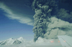
Explosive eruptions
One common type of volcanic cloud contains volcanic gas, air and particles of ash--pieces of the magma that have formed in the explosive eruption. The ash particles are silicate minerals and glass which cool from very high temperatures when they come in contact with the air during eruption. That cooling results from exchange of heat with the air, which, because it is heated so dramatically, expands and rises, carrying the ash with it. The ash can rise high in the atmosphere, often up to 10 km or more and then can persist in the atmosphere for several days or more.
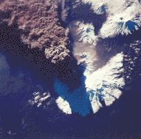
Crater
Peak, Mount Spurr, Alaska--eruption of August 1992
(based on text from the Alaska Volcano Observatory)
In 1992 Crater Peak at Spurr Volcano erupted during three short lived (3 hrs duration) explosive events. The second eruptive phase of 1992 began on the afternoon of August 18 preceded by only a short tremor burst. C-band radar data indicates the ash plume rose to about 14 km (Rose and others, 1995) (pilots estimated the plume height at about 18 km) and small pyroclastic flows again descended the east and southeast flanks of Crater Peak. The eruption lasted 3.5 hours and produced about 52 x 106 m3 of ash. Westerly winds carried the tephra eastward over Anchorage, across the Chugach Mountains and northern half of Prince William Sound, and southeastward toward Yakutat. Up to 3 mm of sand-sized ash fell in Anchorage and coastal communities 1200 km downwind reported dustings of fine ash (Neal and others, 1995). Anchorage International Airport was closed for 20 hours because of the ashfall.
AVHRR Remote Sensing of the August Spurr clouds
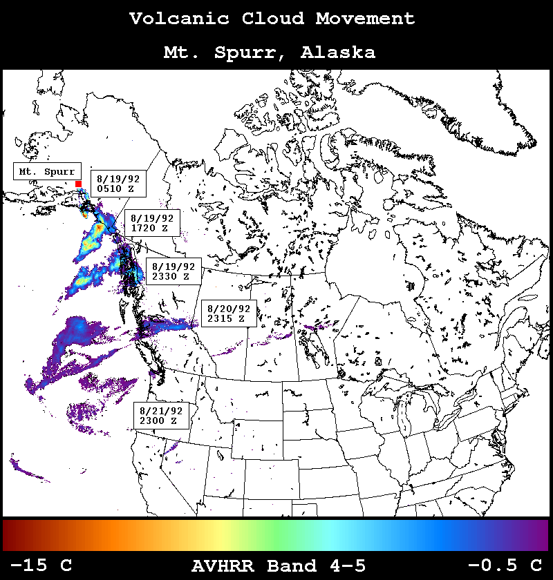
In
this tutorial we use data for about two days following the August
Spurr eruption, during which the volcanic cloud moved steadily to
the SE, along the Pacific coast toward Seattle. The map above
shows views of the cloud as mapped with the satellite. The color
scale bar below shows the brightness temperature differences of
the volcanic clouds, which range from -15 to 0 degrees C. These
are determined from the two thermal infrared channels of the
AVHRR: channel 4 (~10.7 microns) and Channel 5 (about 11.5
microns).
Let's get going!
| Michigan Tech Home | Department of Geological Engineering & Sciences | Remote Sensing Institute | MTU Volcanoes Page | Volcanic Clouds Web Site | Total Ozone Mapping Spectrometer (TOMS) | Volcanic Ash Advisory Centers (VAAC) | Smithsonian Institution | Alaska Volcano Observatory |
http://www.DOMAIN/PATHNAME.HTM -- Revised: DAY MONTH 2000Copyright © 2000 MTU Department of Geological Engineering and Sciences. All Rights Reserved.
Email questions about the content of this Web page to:raman@mtu.edu