Home
Main Topics
Subtopics
Model Description
The Volcanic Ash Forecast Transport and Dispersion Model (VAFTAD) was developed by the Air Resources Laboratory (ARL) of the National Oceanic and Atmospheric Administration (NOAA) for forecasting the visual transport of volcanic ash clouds. The operational use of VAFTAD has been transferred to the National Weather Service to support operations at the Anchorage and Washington Volcanic Ash Advisory Centers (VAAC). VAFTAD results are used to alert aircraft and avoid aviation encounters with volcanic clouds.
VAFTAD is a 3-dimensional Eularian model that calculates the advection and dispersion of volcanic ash
using meteorological and volcanological data. Incorporated into the model are an ash distribution function,
vertical and horizontal advection, gravitational settling of ash, ash diffusion, and ash-air concentrations.
The model computes a "visual" ash cloud that has been calibrated by comparing model-calculated concentrations
with satellite images. The magnitude of the eruption (calculated using user-input of ash column height) is
also utilized in the model. A detailed description of the model can be found on the
VAFTAD Information page.
Model Input
The meteorlogical data used by VAFTAD is generated by the National
Center for Environmental Prediction daily runs that include surface pressure and horizontal and vertical
wind components at 13 pressure levels. NCEP data are downloaded to ARL in 6-hour forecast fields four times
a day. The VAFTAD model utilizes NCEP AVN 191 km formatted data. More information on gridded meteorological
data can be found here.
A list of user-defined input is located on the VAFTAD
Information page. Most input is volcanological information such as the volcano location, height of the
eruption column, and the date of the eruption. The location of the volcano can be specified using latitude/longitude coordinates,
picking a location on a map, or selecting a volcano name from an extensive database.
Model Output
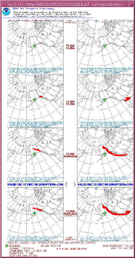
An example of VAFTAD output is shown below. Results consist of 8 panels (four panels in each of two columns). Each
column represents a specified forecast time (hours after eruption). Individual panels illustrate a visual ash
cloud for a particular flight level. Three flight levels are represented (surface-20,000 ft, 20,000-35,000ft,
and 35,000-55,000 ft). The fourth panel in each column is a composite of visual ash cloud results from the
surface to 55,000 ft. These charts do not provide information about ash concentrations. The forecast charts can be
run for 6 and 12 hour forecasts, 12 and 24 hour forecasts, and 24 and 48 hour forecasts. A complete description
of the charts can be viewed on the
VAFTAD Information page.
VAFTAD results may also be posted for current eruptions
within the Washington and Anchorage VAAC areas of responsibility. VAFTAD results are also posted on the web
for hypothetical eruptions of certain volcanoes
within the Washington and Anchorage VAAC areas of responsibility.
Can I run this model myself?
The VAFTAD model can easily be run on-line here. An
enormous database of volcanoes exist to choose from, or the lat/lon can be specified or chosen from a clickable
interactive map. If everything works right, results can be viewed within a minute.
References
All contents on this page were summarized from the VAFTAD
Home Page and subsequent links.
Copyright ©2000 MTU Department of Geological Engineering and Sciences. All Rights Reserved.
Email questions about the content of this Web page to: