|
| Michigan Tech Home | Department of Geological Engineering & Sciences | Remote Sensing Institute | MTU Volcanoes Page | Volcanic Clouds Web Site | Total Ozone Mapping Spectrometer (TOMS) | Volcanic Ash Advisory Centers (VAAC) |
|||
Main Topics Tools
Subtopics Tools Miniature DOAS |
Education and the mini-DOAS Dr. Matthew Watson has incorporated
the use of the mini-DOAS into his Introduction to Remote Sensing course, in
order to provide students with the opportunity to learn more about this new
technology. A current Master’s
student of his, Alex Matiella
has written the following proposal as a project for this course: Using DOAS for Plume Detection in the
Lower Atmosphere Proposal
As gaseous chemicals are emitted
into our atmosphere instruments are needed to measure the amount and
composition of these chemicals. One
relatively new instrument currently being used for measuring gaseous plumes
emitted from different sources is the Differential Optical Absorption
Spectrometer (DOAS). This instrument
indirectly measures the absorption of UV, visible, and near IR radiation by
various gases and aerosol particles in the troposphere. As certain rays are absorbed by a plume,
DOAS records which wavelengths are transmitted through the plume.
Understanding the transmission of these wavelengths can give us a lot of
information about the plume, like its thickness and chemical composition. The DOAS will be used to measure the
absorption of UV, visible, and near IR rays by the plume produced by the
smokestack to the northwest of the Dow Environmental Sciences building. Measurements will be taken at different
distances from the smokestack to evaluate the diffusion of the plume and the
reliability of data taken at increasing distances from the source. The effects of the field of view (FOV) of
the DOAS will also be assessed. This
will help to determine the impact of taking measurements of the same point
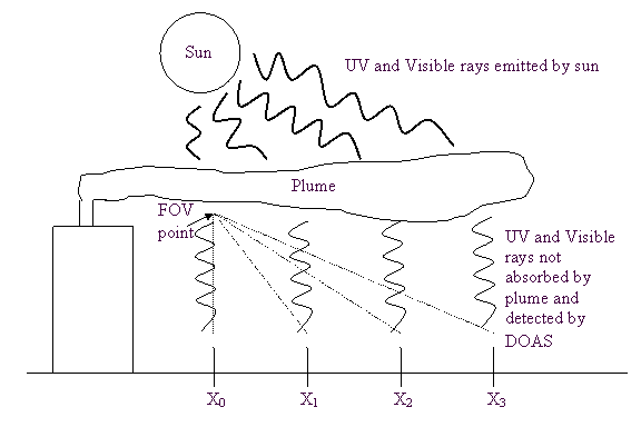
areas of the plume but from different distances. Figure 1 shows the basic experimental
setup. Measurements will be taken at
intervals of 3 to 5 meters from the source, with the DOAS pointing directly
vertical towards the sky to measure the absorption of rays by the plume as
the distance from the source increases and the plume diffuses. Also, measurements will be taken at the
same 3 to 5 meter intervals from the source with the DOAS pointing to an area
of the plume that is within one distance interval from the source. These DOAS measurements will be taken
within the month of April and will be taken over a series of days. The days should have clear weather with
little or no cloud coverage, to minimize the chances of rain during the
experiment, and a strong enough wind to carry the plume away from its
source. The wind should also be at a
constant speed and direction so that measurements are consistent and an
artificial “back-up” or thinning of the plume does not occur. The source of the UV, visible, and near IR
rays will be the sky and the DOAS will be positioned looking upwards so that
it can detect the transmission of radiation through the plume. The results produced will most
likely show that DOAS does accurately measure the diffusion of the plume over
a certain distance. The results of studying
the different field of views of the DOAS are not certain, but they will most
likely show that DOAS measurements do depend on the field of view of the DOAS
relative to the plume and there is a variable of “distance
sensitivity” for the instrument. It is necessary to understand the
limitations of the DOAS instrument so that measurements can be taken under
the most favorable conditions.
Understanding these limitations can help us to collect better data and
use it more efficiently. The broader impacts of this project
will be to show whether the DOAS instrument does work accurately and can be
relied upon when using this instrument in the field for larger plumes, for
example those produced by volcanic explosions and emissions.
meters |
||
|
| Michigan Tech Home | Department of Geological Engineering & Sciences | Remote Sensing Institute | MTU Volcanoes Page | Volcanic Clouds Web Site | Total Ozone Mapping Spectrometer (TOMS) | Volcanic Ash Advisory Centers (VAAC) | Smithsonian Institution | Alaska Volcano Observatory | Copyright © 2002 MTU Department of Geological Engineering and Sciences. All Rights Reserved. Email questions about the content of this Web page to: Yvonne Branan, Lizzette Rodriguez, Alex Matiella or Matt Watson |
|||