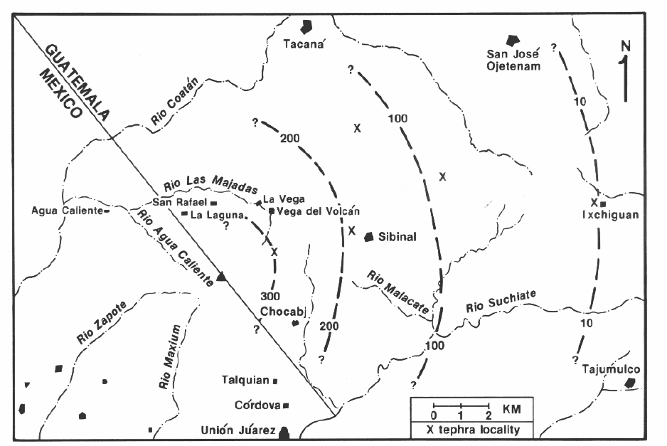
Ash fall deposits were observed up to 20 km away from the summit. The observed occurrences of ash deposits are plotted in the following figure.

- Isopach of Tacaná volcano fall deposits.
Discontinuous plinian fall deposits 3+ m thick are observed on basement at La Haciendita. This ash unit predates the surfical cone lavas, but it can be assigned to an eruption of Tacaná because it thickens considerably toward the volcano and is compositionally similar to Tacaná's lavas. The same unit is about one meter thick at Sibinal and can be traced to Ixchiguan (19 km) where it is 15 cm thick. Tacaná has had at least 3 plinian eruptions in the past as evidenced by observed sequential fall deposits outcropping on the roads from Sibinal to the towns of Tacaná and Ixchiguan.
The areas adjacent to the volcano potentially threatened by accumulation of 1+ m of ash, based on past eruptions, is shown in the pyroclastic flow, mudflow, and flood hazard map on the following page. Ashcloud hazards are of special concern on the Mexican side of the volcano due to greater population density. Many of their population centers can be affected by ash fall in excess of 1 m.
The prevailing wind directions at the time of the eruption will play a crucial role in the determination of areas threatened by ash deposits. Upper level (10,000-50,000 ft) wind directions data provided by INSIVUMEH (Guatemala) indicates that during the rainy season months of June to October winds are predominantly from the east to northeast, and only about 40% of the time does the wind blow from some direction other than 40°-90&3176;. During the dry season months of December to April winds are predominantly from the W to SW, and only about 35% of the time does the wind blow from a direction other than 220#176;-270°.

- Dominant wind directions at 10,000-50,000 feet.
Ashclouds will most likely drift toward Mexico should an eruption occur between June and October. The westerly winds will probably carry the ash plume toward Guatemala should an eruption occur between November and May. These are statistical relationships and winds on a particular day can differ from the averages. For example, the February 1973 Fuego eruption carried ash mainly to the southeast. Well-mapped historic ash falls in Guatemala, such as the 1971 and 1974 Fuego eruptions and the 1902 Santa Mariá event have all carried ash to the west, possibly due to the fact that each of these three examples occurred in the dry season.
(Mercado and Rose, 1992)