IV. Concluding remarks
A. Preliminary statements-why remote sensing should be used
The rapid population growth of the world and the associated changes in the distribution of people have resulted in a rapidly rising toll of deaths and economic consequences from natural disasters (2). Since the early 1970's satellites have been recording and transmitting remote sensing data back to earth for interpretation (3). Most of it remains uninterpreted, but if interpretation methods can be developed and streamlined, the cost of satellites can be balanced against the savings they effect through hazard mitigation. The 1990's will bring a new generation of remote sensors that are designed to allow us to meet the needs of people worldwide (4). The utility of satellite remote sensing data is well recognized for some types of hazard mitigation, such as hurricanes and other weather-related phenomena, where satellite data is routinely used almost everywhere. For other types of hazards, such as volcanic eruptions, the utility is undeveloped, is sporadically and incompletely applied, and needs careful and intense scientific and engineering effort for implementation. There are many theoretically advantageous applications compared to the number that have been seriously tried. Initial results are often unimpressive, because: 1. they require algorithm development, which takes care and time to do well, 2. they often communicate results which were obtained by other more traditional methods sooner, and 3. the cost and accessibility of the methods to those responsible for hazard mitigation around the world reflect the need for new equipment and training. Sharpening interpretive skills of remotely sensed data focused on natural hazard mitigation should be a priority for the remainder of this decade and continue on into the next (5). A coordinated effort to develop algorithms will allow us to interpret data from remote sensors most effectively. Extensive ground truth studies are needed to perfect theoretical computer-based techniques. The technology is available to develop the methods, to make the skills and equipment available to apply these methods worldwide and to disseminate the information to affected populations in time to make a difference.
Many lives and much money have been lost to volcanic eruptions in the last 15 years. Mount St. Helens, 1980 (6); El Chichón, 1982 (7); Nevado del Ruiz, 1985 (8); Mt. Pinatubo, 1991 (9); Unzen, 1991 (10) and Rabaul, 1994 (11) are among the latest eruptions with major losses. The adverse effects of eruptions are often intense and devastating near the volcano but can extend to regional or global scales (12). Basic knowledge of many of earth's 700 or more potentially active volcanoes is minimal; only about 50 have hazard maps and a smaller number have any regular monitoring or field observations. The lengths of repose periods between eruptions vary from minutes to thousands of years, so many eruptions happen at volcanoes with no historic record of eruptions (13), and it is too expensive to put instruments on all potentially active volcanoes. Field observations of any kind at most volcanoes are severely limited. Satellite-based remote sensors collect information regularly over all of earth's volcanoes. This paper is directed toward saving lives and dollars by demonstrating that remote sensing techniques at active volcanoes are a valuable tool to delineate changes in the character of activity, which can help anticipate potential consequent hazards. Connection between the process of algorithm development and a real hazard situation will naturally focus results where they are needed.
B. Volcanoes as a remote sensing target
Volcanoes differ from other natural hazards because they are in fixed geographic locations. This is an important advantage for most remote sensing applications because for this application the whole world does not have to be imaged, only the volcanoes and their flanks. This spatial advantage is mitigated by the fact that the timing of eruptions is erratic and long reposes occur. During these repose periods remote sensing is less effective, because little change can be detected. Vegetation covers the slopes of many volcanoes quickly during a repose period, masking the differences in texture, composition and and other characteristics which serve to delineate volcanic units at active volcanoes with unvegetated slopes.
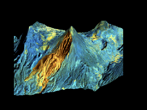
The basic description of the topography of a volcano is one of the most important parts of volcanic hazard evaluations, because most volcanic hazards are controlled by gravity and topography where volcanoes are topographic highs which threaten their lower lying surroundings through gravitational potential energy. At all volcanoes, including those in repose, synthetic aperature radar remote sensors can provide valuable data which describes the topography. Topographic data can be used for the formulation of models predicting which path a pyroclastic flow or lahar or any gravity driven hazard may follow.
In this study we are interested in highlighting the capability of a broad range of remote sensors, including radar, microwave, infrared, visible and ultraviolet. For the initial evaluations of the potential of these, we think that active volcanoes, which exhibit constant changes and which are not covered with masking vegetation are the best targets for study.
Active volcanoes make spectacular remote sensing targets because a variety of phenomena that are not common in the typical environment at the earth's surface can be found:
Each of these four features of the volcanic remote sensing targets is of potential use in hazard mitigation. In addition, repeated topographic surveys to define topographic changes is of critical value. In the sections that follow we will describe how remote sensing may be used effectively for hazard mitigation at an active volcano, using Santa María and existing satellite data as examples.
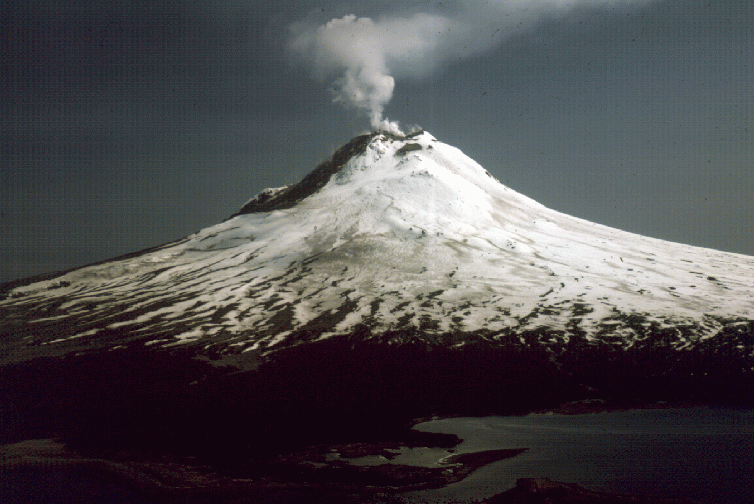
In response to the international recognition of the need for a concerted effort at natural hazard mitigation, the United Nations has sanctioned the International Decade of Natural Hazard Reduction and the International Association of Volcanology and Chemistry of the Earth's Interior (IAVCEI) has instituted a designation of International Decade Volcanoes, to focus volcanological efforts at hazard mitigation on a few especially relevant volcanoes (14). One of 15 officially designated decade volcanoes is Santa María, Guatemala (15), which has already been the subject of an international scientific workshop (16). An online version of the workshop's report is available. Santa María has been continuously active since 1922 and has a large variety of phenomena which make it an outstanding remote sensing target. We have selected this volcano as the subject of this paper, because it is a prime target for the evaluation of how remote sensing of an active volcano can be directed at mitigating hazards. There are many distinct environmental aspects of this volcano that make it a research site of particular value, both for testing algorithms and for general scientific merit. In this paper we will identify and highlight these, and also compare this site with some other useful choices. To view a map of Guatemala and the area surrounding Santa María click here .
C. Why do we need to go to the field and what kinds of field sites are best?
Field sites play a vital role in developing remote sensing capability by allowing verification of models and ensuring that remote sensing works in the way envisioned. It also provides an opportunity to develop better and more diverse models by ensuring that direct experience with the volcano occurs. Ideal field sites would be constantly active, and have activity which constantly changes in character allowing many experiments to be done in each field visit. In nature it is impossible to find a single volcano which has all kinds of activity, and we think that at least two frequently active volcanoes (one effusive and one explosive) are needed to allow for the kinds of ground truth that are needed for comprehensive algorithm development and verification.
D. Why remote sensing at active volcanoes?
The value of remote sensing as a hazard mitigation tool at volcanoes is not directed measuring things that forecast volcanic activity, but instead at mapping the changes resulting from activity that are and may be associated with subsequent hazards. There are many examples of these kinds of changes that lead to subsequent hazards:
These kinds of changes happen all the time at active volcanoes, but are not usually recorded, because regular field observations are very limited. Satellite remote sensors can detect and map many or all of these changes, and their regular coverage is a way to facilitate regular observation. We use TM as a main vehicle for demonstration here because it has been collecting repeated data for more than 12 years, and can demostrate the value of repeated observations. It also has capability which is also available through ASTER, with improved resolution in the EOS (Earth Observing System) platform.
E. Goals of this paper
A. Weather and ideal observation times
Volcanoes are typically in environments with strong characteristics. The shape of the volcano itself leaves a strong imprint on its local weather and topography. Santa María is in a highland tropical winter dry season climate regime, and is characterized by frequent fog. The mean annual temperature is about 15 C and does not vary much from month to month. The temperatures range from a maximum of about 35 C at noontime at low elevations south of the volcano to about 0-5 C at the summit of Santa María at dawn. The mean annual rainfall is about 4 m on the south flank near Santiaguito, with nearly all of it coming between April and October. Rainfall is much less (approx. 2 m) on the north flank of Santa María. The cloudiness and fog have a regular pattern which builds up clouds each day as solar energy heats the land surface. On many days, and particularly in the dry season (November-April) the atmosphere is cloud-free in the early morning. This is a fortunate fact given the morning overflight time (945 am equator, ascending orbit) of the LANDSAT TM, because in spite of the tropical wet location there are an abundance of cloud free TM images (table 1). The advantages of the AM overflight will be maintained by the EOS-AM1 satellite platform, because its orbits over Santa María (1030 am equator crossing, descending orbit) will put it over the volcano at about the same local time (1000 am). The EOS-PM1 will be far less favorable, with an equator crossing at 1330 local time, when conditions are nearly always cloudy.
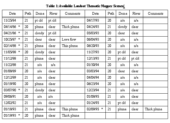
* denotes previously purchased scenes. n/a indicates scenes in which only quick looks or microfiche were available and their resolution is such that the information is difficult to determine.
B. The volcano and its surroundings
 Elevations in the area range from less than 500 m to 3768 m, the elevation of Santa María's summit. The regional topography slopes from the volcanic highland on the north at about 2500 m to sea level on the south, and the volcano is built on a sloping irregular basement. The summit of Santa María (3768 m) is a quiet accessible platform for viewing the active vent of Santiaguito.
This is a spectacular advantage for observations of thermal anomalies and volcanic eruptions.
Elevations in the area range from less than 500 m to 3768 m, the elevation of Santa María's summit. The regional topography slopes from the volcanic highland on the north at about 2500 m to sea level on the south, and the volcano is built on a sloping irregular basement. The summit of Santa María (3768 m) is a quiet accessible platform for viewing the active vent of Santiaguito.
This is a spectacular advantage for observations of thermal anomalies and volcanic eruptions. 
 Video, transferred to mpeg , was collected in 1993 during the international workshop. Access to Santa María is good: a 3 km hike to the summit which rises 1200 m in elevation over a steep trail takes 3-4 hours from the place where you can drive a car.
Excellent viewpoints from the south side of Santiaguito can be reached by 4WD vehicles. Ground access to Santiaguito itself is challenging, but two trails from the north are available. For details on access click here.
C. Variety of activity
Besides its advantages for viewing geometry, Santa María offers an extraordinary variety and frequency of volcanic activity. It has been continously active since 1922 and the kinds of activity that can be seen in a few days' observation typically include dome extrusion, lava flows, avalanching, pyroclastic flows, debris flows of various types and vertical ash eruptions. Of the satellite images so far acquired (Table 1), a majority show evidence of active eruption clouds, all show distinct thermal anomalies associated with the volcano, and there are substantial changes detectable with each new image. In the sections that follow, we show how observing Santa María will help us learn how to perfect methodology related to:
The various types of hazards associated with Santa María are available online.
D. Comparison with other field sites
Considering the unusual combination of access, topographic layout and the consistency and variety of activity, Santa María is clearly one of the very best volcanoes in the world to do basic ground truth for development of remote sensing for volcanic hazard mitigation. The following briefly describes some other sites and their particular advantages and disadvantages as a field site in comparison to Santa María.
Unzen, Japan.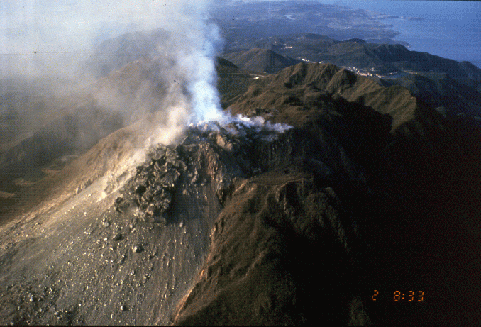
 Unzen is an active lava dome in Southern Japan. It began renewed activity in 1990 and has continued until the present. There were phreatic and phreatomagmatic eruptions in late 1990 and early 1991, followed by dome extrusion and pyroclastic "block and ash" flows in late 1991. The extrusion has continued, but is declining in its rate. The volume of lava extruded at Unzen in its first few years is of the same order of magnitude as that extruded in the first few years of Santiaguito (1922-25) and Mount St Helens (1980-83). The advantage of Unzen as a field site for thermal and gas emission measurements has already been demonstrated (17) , (18) , (19) , (20) .
Good lateral observation sites using nearby mountains are available, (but none from above the dome). The volcano has a variety of regular observational data available to support the context and interpretation of remote sensing. The volcano has most of the same kinds of activity that can be seen at Santa María and has better logistical access. It is a prime site for developing hazard capability, as long as activity continues.
Unzen is an active lava dome in Southern Japan. It began renewed activity in 1990 and has continued until the present. There were phreatic and phreatomagmatic eruptions in late 1990 and early 1991, followed by dome extrusion and pyroclastic "block and ash" flows in late 1991. The extrusion has continued, but is declining in its rate. The volume of lava extruded at Unzen in its first few years is of the same order of magnitude as that extruded in the first few years of Santiaguito (1922-25) and Mount St Helens (1980-83). The advantage of Unzen as a field site for thermal and gas emission measurements has already been demonstrated (17) , (18) , (19) , (20) .
Good lateral observation sites using nearby mountains are available, (but none from above the dome). The volcano has a variety of regular observational data available to support the context and interpretation of remote sensing. The volcano has most of the same kinds of activity that can be seen at Santa María and has better logistical access. It is a prime site for developing hazard capability, as long as activity continues.
White Island, New Zealand.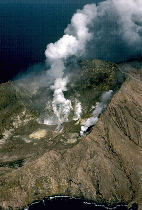
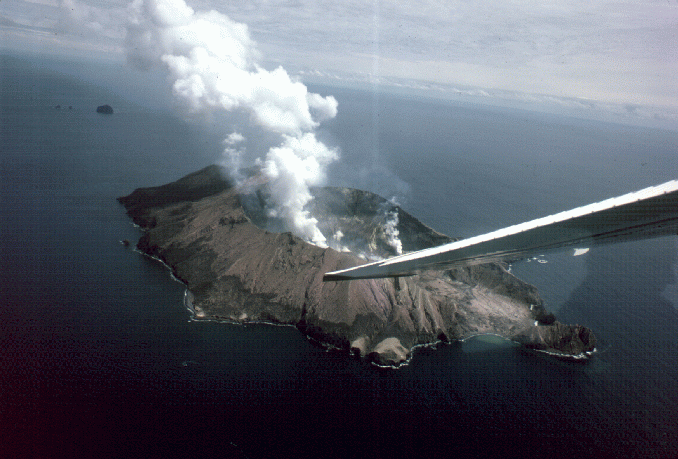 White Island is an active volcano 50 km offshore at the NE end of the Taupo Volcanic Zone of New Zealand's north island. It has been in continuous solfataric and fumarolic acivity for at least 150 years (21) . Small phreatic eruptions have been more common in recent years. This is an excellent gas emission field site, because high quality direct gas sampling is regularly possible and gas emission rates are high. There are no permanent inhabitants on the island and so hazards from its activity are limited to long range effects (tephra fall, acid fumes, etc) and to the possibility of tsunami. Volcanic hazard study applications there are mainly for the study of gas plumes, which are continuous and large. It has a lot of extensively altered areas in the crater, so study of clay alteration is also possible.
Colima, Mexico.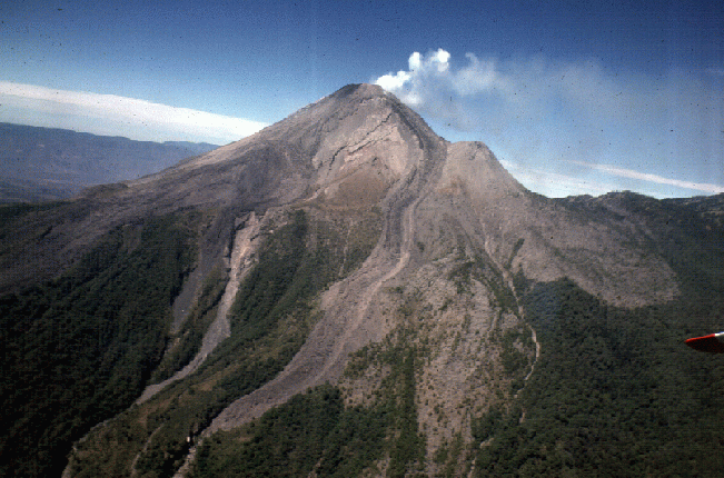
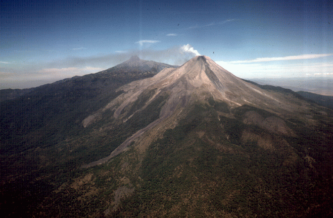 Colima, a Decade Volcano, is located at the western end of the Mexican Volcanic Belt, west of Guadalajara. It has been Mexico's most consistently active volcano over the past 400 years (22) . In recent years Colima has produced lava flows, dome extrusion, block and ash flows, mudflows and continual gas emissions. It has a drier climate and clearer atmospheric conditions than Santa María. Logistical access is similar to Santa María, although the height and relief of Colima is significantly greater. The topographic relationship between Nevado de Colima and Colima itself resembles Santa María and Santiaguito, but is not nearly as favorable a viewing site.
Augustine, Alaska.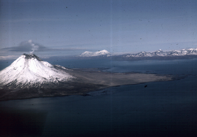
 Augustine, an island volcano in Cook Inlet, is a dome complex with pyroclastic fans surrounding it. Its activity has been sporadic in recent decades with activity in 1976 and 1986, and only weak gas emission since. It is a poor site for developing remote sensing capabilties for hazard mitigation unless activity resumes and unless this activity becomes long lived.
Etna, Sicily.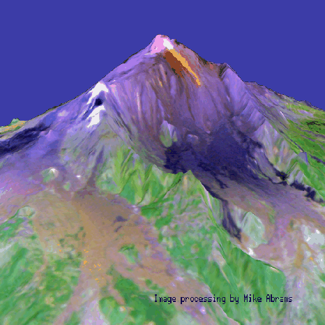 Etna is a large stratovolcano with frequent activity consisting of lava flows, vertical ash eruptions and continual gas emissions from both central and lateral vents.
Activity is varied and changeable and creates real and extensive hazard. It is intensively studied and is a prime site for learning hazard mitigation techniques for remote sensing, particularly those associated with lava flows and gas plumes (23) , (24) . The Istituto Internazionale di Vulcanologia in Italy has a homepage containing images and information regarding the volcano.
Etna is a large stratovolcano with frequent activity consisting of lava flows, vertical ash eruptions and continual gas emissions from both central and lateral vents.
Activity is varied and changeable and creates real and extensive hazard. It is intensively studied and is a prime site for learning hazard mitigation techniques for remote sensing, particularly those associated with lava flows and gas plumes (23) , (24) . The Istituto Internazionale di Vulcanologia in Italy has a homepage containing images and information regarding the volcano.
Kilauea, Hawaii.
 Kilauea has been almost continuously active since 1983. It has produced lava flows, lava fountains and continual gas emissions, and has presented serious lava flow and volcanic fog hazards to the Big Island. It is a prime site for development of lava flow and gas emission algorithms (25) , (26) , (27) . Logistics are excellent. (Pete Mouginis-Mark has a collection of slides on line of the ongoing eruption.)
E. Summary of site selection factors
In summary, no one site is optimal for all types of hazard mitigation efforts. It seems that at least two are needed, with one being Kilauea or Etna (effusive volcanoes), the other being Santa María, Unzen or Colima (silicic, Circum-Pacific type volcanoes). The differences are subjective and do not resolve into a clear rating. All five sites are excellent choices. The advantages of Santa María over Colima or Unzen are:
The advantages of Unzen are its smaller scale, simpler logistics and excellent supporting scientific infrastructure. The one clear advantage of Colima is its proximity to the US.
The specific aspects of how Santa María's environment is advantageous for developing hazard mitigation techniques using remote sensing are explained in the sections that follow.
A. Thermal anomalies
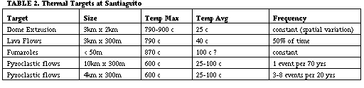
Actively erupting volcanoes typically have hot areas that can be detected by satellite sensors. Santa María has several types of thermal anomalies that are detectable (Table 2) and the pattern of thermal anomalies is different on each successive image.  The Landsat thematic mapper (TM) provides 30 m ground resolution in six spectral bands (3 visible, 1 near infrared and 2 mid infrared) and 120 m ground resolution in one band (band 6) of thermal infrared. Band 6 can be used to demonstrate differences in activity which affect larger anomalies such as active block lava flows at Santiaguito. For smaller and hotter (>100 C) anomalies the thermal infrared band can be saturated but other infrared bands can be used.
The thermal anomalies around the Caliente Vent are associated with active dome extrusion and fumarolic activity. They produce dual band signals (usually bands 5 and 7 of TM) which can be used to retreive the temperatures of subpixel thermal features, (28) and this subpixel information may be very useful in the interpretation of thermal anomalies (29); (30) . A
The Landsat thematic mapper (TM) provides 30 m ground resolution in six spectral bands (3 visible, 1 near infrared and 2 mid infrared) and 120 m ground resolution in one band (band 6) of thermal infrared. Band 6 can be used to demonstrate differences in activity which affect larger anomalies such as active block lava flows at Santiaguito. For smaller and hotter (>100 C) anomalies the thermal infrared band can be saturated but other infrared bands can be used.
The thermal anomalies around the Caliente Vent are associated with active dome extrusion and fumarolic activity. They produce dual band signals (usually bands 5 and 7 of TM) which can be used to retreive the temperatures of subpixel thermal features, (28) and this subpixel information may be very useful in the interpretation of thermal anomalies (29); (30) . A  comparison of TM band 7 anomalies around the Caliente Vent and the results from a dual band subpixel calculation was made by Andres and Rose (34) using the 1986-88 TM images.
We conclude that imagery with the spatial resolution and thermal band pattern similar to TM can provide very useful data on the activity at volcanoes like Santa María, but there is a need for descriptions and observations of the thermal
anomalies that are found on volcanoes like Santa María (31) .
comparison of TM band 7 anomalies around the Caliente Vent and the results from a dual band subpixel calculation was made by Andres and Rose (34) using the 1986-88 TM images.
We conclude that imagery with the spatial resolution and thermal band pattern similar to TM can provide very useful data on the activity at volcanoes like Santa María, but there is a need for descriptions and observations of the thermal
anomalies that are found on volcanoes like Santa María (31) .

We recommend that high resolution thermal study of Santiaguito be made with thermal radiometers from ground survey points such as the Santa María summit. Such surveys will give valuable detail for the interpretation of satellite based anomalies. Although there has been initial discussion about some of the thermal anomalies on domes (32) , (33) , there is a need for careful ground truthing of thermal patterns, which could provide a valuable tool for understanding the internal structure and potential failure patterns.
Eventually satellite based observations should target regular analysis of thermal infrared data aimed at detection of changes in activity. At Santiaguito there are several examples of changes in activity that are detectable by regular thermal imagery:
Regular observations of thermal data at Santa María are expected to provide valuable experience to enable the development of satellite based thermal measurements at active circum- Pacific type volcanoes. Substantial changes seen in the thermal patterns at Lascar, Chile, over a period of eight years using TM data (33) demonstrate that changes will be detected by satellite sensors. We can anticipate that at Santa María, where activity has affected a much larger area than Lascar, that the record of thermal changes there will be far more varied and extensive, and results by Andres and Rose (34) for a 2 year period strongly support this. So a ten year period of study is likely to produce a record that mirrors a substantial variety of changes in activity. A retrospective look at thermal changes in the past ten years, based on the thermal data from the images in Table 1 is underway. This study will allow the evaluation of whether thermal patterns of the dome can be used to measure eruption rates as well as the variety of changes in eruptive style, because we have independent observational data over the past 10 years to compare with the satellite results.
The Advanced Very High Resolution Radiometer (AVHRR) data of the Kupaianaha lava flow field, Hawaii, have been used to develop a model for a thermal alarm for large basaltic eruptions (35) . Anomalies must exceed 60m2 and have temperatures in excess of 1000 C before they are detected by AVHRR sensors (IFOV of 1000m). Quantitative analysis of these targets may not be possible due to the dynamic range settings of the sensor and its coarser spatial resolution (36) . The size and temperatures of typical anomalies at Santa María (table 1) suggest that moderate resolution sensors are ineffective tools for continual studies at active silicic vents similar to Santiaguito. Several AVHRR images have been viewed and no anomalies have been detected near any of the active vents in the Guatemalan highlands. However, unlike TM, the orbital timing of AVHRR puts the satellite over Santa María at times when clouds may be inhibiting collection of useful data.
Application of a thermal alert is planned for use with the Moderate Resolution Imaging Spectroradiometer (MODIS) (37) , scheduled for a 1998 launch aboard NASA's EOS AM-1 platform. Four of MODIS' 36 channels could be used for the alarm, three of which have an IFOV of 500m. The higher spatial resolution of these channels may allow the alarm to be applied more successfully at vents similar to Santiaguito.
B. Volcanic cloud sensing
Volcanic clouds may be detected by sensors that measure absorption by gases in the cloud such as TOMS (38) or TIMS (24) , by infrared sensors such as AVHRR (39) or HIRS (40) which detect particles in semitransparent drifting clouds, by comprehensive sensors such as TM which can detect both opaque and transparent clouds with a resolution of about 30 m, and by microwave or radar sensors such as SSM/I (41) , which can detect only large active eruption columns or very young (<1 hr old) clouds. Santa María has very frequent vertical eruptions, often more than 1/hr, but they are limited in height (usually < 2 km), in duration (usually < 2 minutes), in area (usually < 50 km2) and in gas burden (usually < 2 kt SO2). The small scale limits the utility of satellite detectors: 1. AVHRR and HIRS have limits that demand both significant plume area (> about 100 km2) and significant plume height (> about 1 or 2 km) to map clouds 2. TOMS requires a significant burden (>about 10 kt) of SO2 and 3. SSM/I requires both significant area and eruption intensity, so it may only be useful on large eruptions (41) .
TM imagery is demonstrably valuable at volcanoes like Santa María for volcanic cloud detection. 
 The clouds can be analyzed for determination of heights and areas, and the observations of such events can be used as a measure of a minimum level of activity. We note that such clouds are visible in a significant percentage of TM images at Santa María (Table 1). Large clouds (especially those detectable by TOMS, AVHRR, HIRS and SSM/I) will be relatively uncommon, but when they do occur their tracking and information retrieval will be useful in mitigating aircraft hazards (42) .
The consistent small scale explosive eruptions and the excellent viewing access makes Santa María an exceptional site for ground truth study of small scale eruption clouds. Video taken from the summit of Santa María shows the evolution of a small eruption cloud. It is possible to plan systematic repeated observations of evolving eruption clouds from a variety of perspectives including observations with a background of "warm" ground. Field campaigns with a variety of sensors to observe the eruption clouds could help develop and verify a variety of gas and particle sensing algorithms.
C. Sensing fresh rock surfaces
One of the most useful aspects of remote sensing in a tropical volcanic region like Guatemala is the ability of the visible and infrared radiation to discriminate between fresh rock and vegetated surfaces. This is useful because vegetation quickly develops on all areas except those disturbed by the volcano or other causes (urban development, etc). Fresh rock surfaces are found on all the active parts of the volcano, and they become vegetated as activity no longer affects certain areas. So the spectral characteristics of volcanoes vary from being very similar to surrounding vegetated areas, to the distinctly different responses of bare rock. Fresh rock surfaces are typically found along the river valleys where active sedimentation is occurring, and can continue for many miles from the volcano, portraying the areas of accelerated sedimentation affected by the volcanic activity.
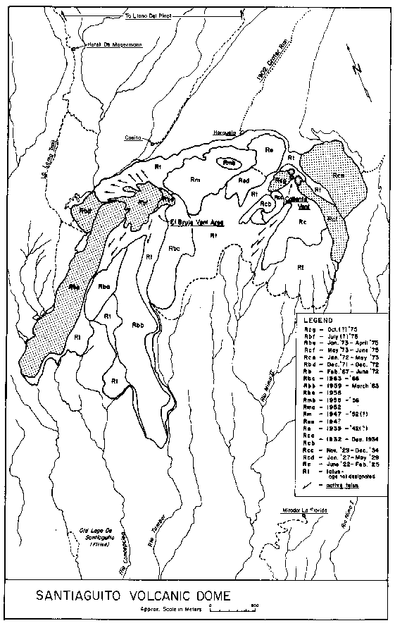
Variations in the dome complex itself can be seen in the response of different parts of the dome. This is a reflection of the time since the eruption of a particular part of the dome. The older units are increasingly covered by vegetation. Repeated imagery of the active dome shows changes and in particular new units of the dome. 
Comparison of three images of the river valley in the lower elevations south of the dome depicts changes in the sedimentation patterns that have occurred during the three years of observation.
The aggradation of streams in this environment of rapid sedimentation leads to frequent stream capturing and changes of channels. Each change of channel can in turn lead to downstream changes where aggradation begins in a channel that has not experienced this before. Because settlements occur commonly along river valleys, these shifts in sedimentation caused by the volcano cause disruption of settlements and can be anticipated by satellite observations of river valleys leading from the volcano. 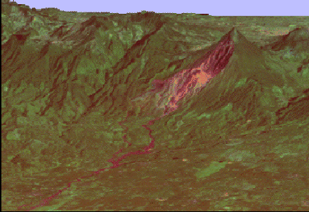 Because hazards of one kind frequently lead to another (e.g. pyroclastic flows to lahars to floods) governed by gravity and topography, the visualization of the hazard zone with respect to topography is vital for forecasting subsequent hazard.
A time perspective of ten years will provide a tool to estimating the age of a fresh rock surface because we know, from regular ground observations and mapping, the ages of a variety of surfaces and therefore the time that revegetation has been operating. The 10 years of TM data can be used to characterize the site specific spectral responses due to revegetation. This will demonstrate how multispectral imagery can be used to estimate relative and absolute ages of fresh surfaces (exposure ages). This tool is expected to work well at Santa María, because the humid nature of the area causes revegetation to occur rapidly, and areas of the Santiaguito dome active in the 1970's (El Brujo) are already covered with a significant veneer of plants.
D. Clay minerals, linear features and other miscellaneous items
Volcanoes, and Guatemalan volcanoes in particular (43) are well known sites for edifice collapse. This kind of hazard is rare (about 4 per century worldwide) but extremely devastating. Dome collapses are especially serious, because they can involve hot dome cores that lead to pyroclastic flows (44) . We know too little about precursors of collapse, but there are several aspects of Santa María/Santiaguito which are worthy of consideration:
It makes sense to try to use remote sensing data to attempt to detect precursives to edifice collapse, and we suggest two ways that this may be attempted: 1. To look for clay mineral spectral patterns in the fresh rock exposures of the dome complex and the steep 1902 crater walls. Clay minerals have distinct absorption characteristics that make them distinguishable from other silicates in TM images, as studies of hydrothermally altered areas in desert regions have shown.2. We aim to examine in detail the spectral characteristics to see if areas of anomalous clay minerals may exist. We also plan to examine whether any linear or arcuate patterns of fractures and/or alteration can be seen in any of the bare rock surface areas exposed in the TM images. Because high spatial resolution is required, the lower resolution detectors are not so useful in these efforts.
E. Need for topographic data
Lack of current topographic data is an important gap in our capability to demonstrate hazard information from remote sensing at Santa María. We have digital topography derived from topographic maps based on 1954 air photos, obtained through the USGS (Al McEwan, Flagstaff) which covers the immediate area of the volcano and part of the way to the coastal plain. We have requested stereo SPOT, but so far it has not been possible, because of clouds (SPOT is about 1 hour later in the morning, apparently a significant factor). It is vital to get more recent topography, and to develop a method of measuring changes, because these kinds of changes, both on the volcano and along the river valleys to the south, drive hazard zonation changes. It is important that we investigate and push the possibility of a special flight from NASA for TOPSAR and TIMS. This effort would provide vital data for our project, and because of the advantages of the site, would provide a highly useful data set on an active volcano. If planned carefully, a roundtrip flight from San Jose, Costa Rica to Guatemala along the volcanic front could be done in one day and could obtain basic TOPSAR and TIMS data of twelve of the world's most active volcanoes (Santa María, Fuego, Pacaya, Izalco, San Miguel, San Cristobal, Telica, Cerro Negro, Masaya, Arenal, Irazu and Poas), which would be a vital baseline data set for activity in the next decade. We have contacted OFDA and Central American volcanologists about making a formal request from the Central American governments. This should be high priority, because it is very likely that one or two of these sites will have disasters in the next decade. The data can be used in mitigation efforts at those locations.
F. Transfer of learning from Santa María to other volcanoes
Santa María is representative of many convergent plate boundary volcanoes that are erupting magmas of andesite or dacite such as Mount St. Helens, Merapi, Pinatubo, Unzen, Colima, Nevado del Ruiz and hundreds of others, especially along the Pacific rim. Santa María exhibits many different volcanic hazards: tephra falls, pyroclastic flows, silicic lava flows, debris flows, edifice instability and volcanic dome collapses (15) . The continuous activity means that study over only a few years will present a variety of practical challenges that are likely to improve our hazard applications of remote sensing. And because the tropical location of Santa María is analogous to the world's most densely populated volcanic regions (Indonesia, Phillipines, Central America), the liklihood of transfer of skills to a large number of potentially hazardous volcanoes is high.
IV. Concluding remarks
 In order to learn how to use remote sensing to mitigate volcanic hazards, practice on a volcano which is continually active is vital, because hazard mitigation can best be made from repetitive imagery which detects and maps changes. The interpretation and mapping of successive changes provides a tool for anticipating the hazards that may happen next, and the places that will most probably be affected.
No one volcano is adequate as a field training focal point, because no one volcano exhibits regular activity of all varieties. We think that two sites can provide nearly all of the activity styles, however. The two sites should consist of one circum-Pacific (or convergent plate boundary) volcano and one effusive volcano. Candidates for the former are : Santa María, Colima, Unzen, Augustine and White Island, while candidates for the latter are Kilauea and Etna.
Santa María has some exceptional advantages.
There is no other site we know of with all these advantages.
Disadvantages of the Santa María site are:
There is a compelling need for updated topographic information about the Santa María site, and we recommend that it be targeted for a special NASA flight to use TOPSAR and TIMS instruments to obtain important baseline observations. On the same flight 12, other hazardous volcanoes in Central America could also be imaged.