Priorities of Current Hazard Study

- Local residents of Guatemala's volcanic front, coming home from market day at Santiago Atitlán. The volcanic front is densely populated in Guatemala. Photo by Bill Rose.
Santiaguito is a dangerous volcano, and has shown continuous activity. There are two potential hazards which should concern Guatemalans most. First is the virtually certain problem associated with rivers south of the volcano that receive the volcanic debris. Problems have been occurring at El Palmar for more than 10 years, but the things are worsening and could spread to other, more populous towns downstream. Second, is the possiblility of a recurrence of dome collapse and associated pyroclastic flows such as those that occurred in 1929. Although not a certainty, such collapses represent such serious catastrophes that they merit efforts which possibly could detect warning signals.
A synopsis of each of these problems, and some simple recommendations are included in the following paragraphs.
I. Hazards in rivers south of Santiaguito and attempts to anticipate the effects of coninual aggradation of river channels:
The current and coninuing activity at Santiaguito is causing accelerating problems for rivers which receive the volcanic debris. The problem is now serious for the town of El Palmar, but it could also affect several towns farther downstream. Some of the points along the river valleys are very close to a radical readjustment which would direct flow of rivers, causing dramatic erosional and depositional effects. This could affect towns and roads profoundly. The possiblilities here are diverse and require historic data that may not be available. In summary the rivers are building up their base levels, which will eventually cause them and their tributaries to flood neighboring areas. The situation should be watched with periodic river surveys and new aerial photographs will be obtained. The river surveys are being carried out by INSIVUMEH Engineers, and will be periodically repeated to keep track of elevation changes at critical points along the rivers. The new photos will be taken by the Instituto Geográfico Militar in May, and the USGS plans to use them to make a revised topographic map. This map is necessary to allow better forecasting of areas which could be flooded. It also may form a basis for diversion efforts, which may be possible to ameliorate part of the problem.

II. Clarify the descriptions of the 1929 catastrophic dome collapse and interpret it in current context:
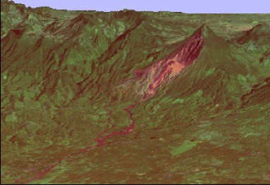
In 1929 a catastrophic collapse of Santiguito occurred, devastating more than 15 km², destroying several plantations and killing at least several hundred people (some sources report as many as 5,000 people killed). The best account of this eruption (Sapper and Termer, 1930) documents many details of this eruption and the affected area (see figure below).

- Map showing the areas affected by some large block and ash flows from Santiaguito.
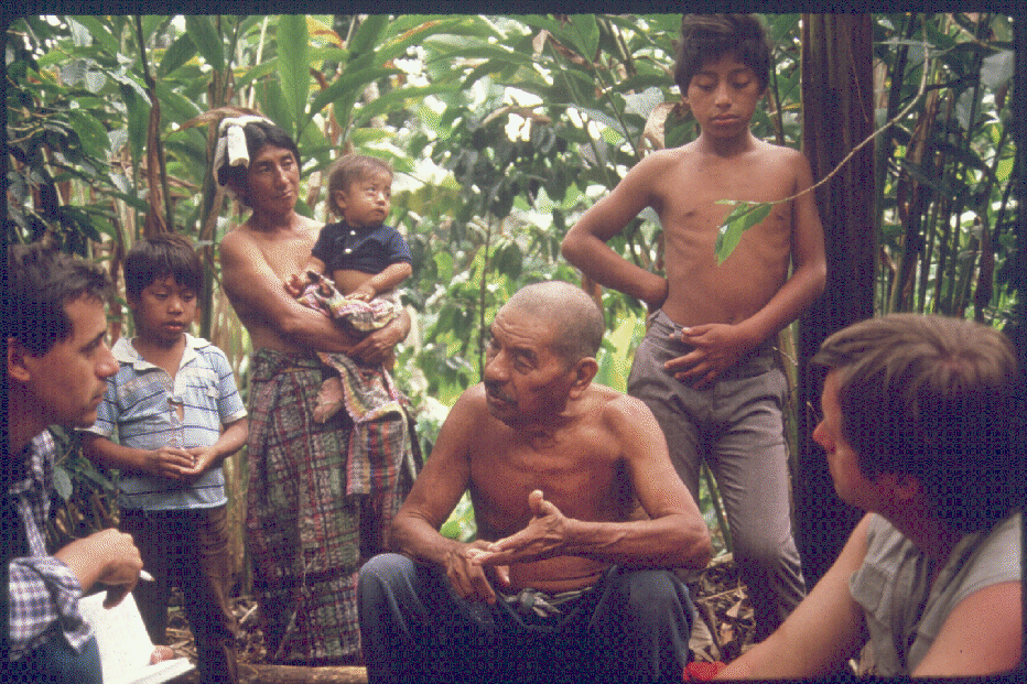
We had the opportunity to interview a 78 year old witness of the disaster; his memories of the event closely matched Sapper and Termer's account.

- Interviewing Don Patricio Herrera, a witness to the November 1929 eruption of Santiaguito, near El Palmar. Photo by Jon Fink.
This eruption has many analogies with dome collapse eruptions such as those described at Marapi Volcano, Indonesia. This example shows that reoccurrence of such eruptions is possible or likely, and that the scale of such phenomena may vary. Santiaguito has shown a similarly variable scale with small (1973) and moderate (1929) collapses. The activity of Santiaguito is similar to 1929 and the height of the dome is similar, although the dome has spread laterally and is now much more complex. We suggest that the possiblility of dome collapse and associated pyroclastic flows are still a real possibility, and the dome should be monitored for precursory deformational changes which could provide notice of possible collapse. EDM surveys with targets on the dome itself would be advisable.
Expected Hazards from Continued Dome Extrusion
Based on Santiaguito's activity since 1922, it is possible to forecast expected hazards for areas surrounding the dome. Most of the hazard zones reflect the topographic slope to the south, which is an overwhelming influence.
I. Zone of extreme hazard due to active dome extrusion, lava flows, avalanches, block and ash flows, lahars, and floods:
This comprises the immediate area of the dome and areas downslope. Most of it has slopes of more than 10 degrees and it is generally uninhabited. Within this zone, all hazards tend to focus on the current active part of the dome, which can shift periodically. Given the steep slopes wouth of Santiaguito, this zone would be hazardous even without constant volcanic activity. Because of the increased tendency for lava flows to be extruded to the south, this hazard zone is expanding southward. It is possible that a new part of the dome could appear, which would expand all of the hazard zones.

- Small block and ash flow descending from the El Brujo vent at Santiaguito, July 1967. Photo from Magermann site by Bill Rose.

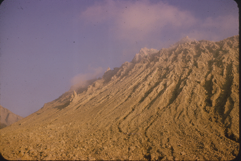
- Active rockfalls from the activity of the El Brujo vent, July 1967. During dome extrusion at Santiaguito, rockfalls are very common, building up broad talus aprons. Photo by Bill Rose.

- The broad talus slope north of the El Monje Dome Unit at Santiaguito. The El Monje spine can be seen at the midpoint of the talus slope. Photo by Bill Rose, 1969.
II. Zone of potential extreme hazard due to block and ash flows and associated pyroclastic surges generated from collapse of the dome:
This zone is based on the 1929 eruption (Sapper and Termer, 1930; Ospina, 1930). The effects of such collapses may be expected to reoccur at volcanic domes. Large areas might be buried with several meters of hot debris and larger areas affected by hot volcanic surges. We have outlined this zone in 2 divisions, one which follows closely the 1929 example, with a source at the Caliente Vent portion of the dome. We consider this somewhat more likely, in view of the continual activity at this central vent. The second zone outlines areas that could be affected if peripheral parts of the dome collapsed. As the 1929 example shows, such collapses can apparently occur without much warning. This makes them a difficult type of hazard to confront.

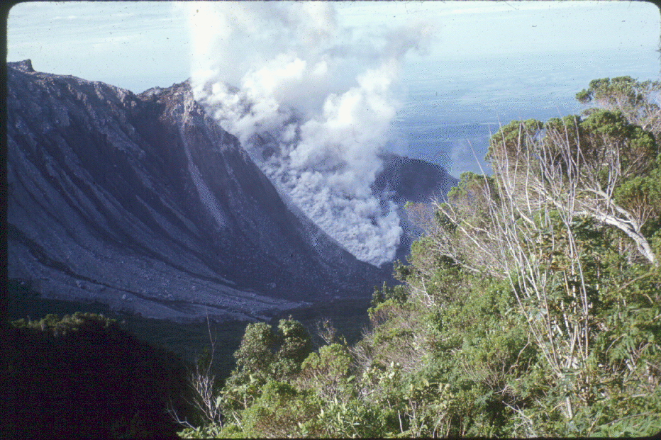
- Active block and ash flow and elutriated ash cloud from the Caliente vent area, July 19, 1989. This flow traveled about 4 km down the valley of the Río Nimá II. The photograph was taken from El Palmar, 10 km S of Santiaguito, by F. Michael Conway.
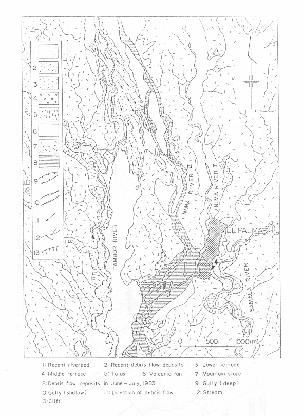
III. Zone of extreme hazard due to laharic deposits and floods:
These are areas encompassing the floodplains of rivers which drain the area affected by volcanic sedimentation from Santiaguito. These river valleys are filling, full or overflowing with mudflow and fluvial sediments. Thus the areas expand continually as the river aggrades and may eventually overflow into neighboring drainages. Bridges crossing these rivers can be expected to periodically need attention and flooding at the confluence of tributaries should be expected. The intensity of problems with these zones correlates with the position of volcanic activity- the current focus on the Río Nimá II reflects the loading of that drainage by the Caliente Vent. Only areas showing active or imminent aggradation are included.

- Damaged area of El Palmar and geomorphological condition (Flood Control Project No. 72, 1985).

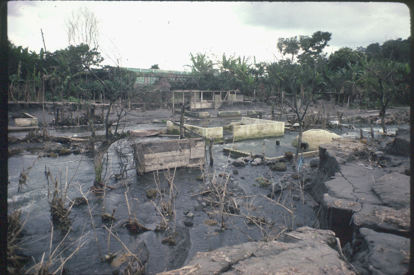
- A view of some of the buildings of El Palmar that were devastated by a mudflow in September 1983. Photo by Bill Rose.
IV. Zone of potential extreme hazard due to flooding, laharic deposits, and alluvial sediments:
These areas are those most likely to receive aggraded materials at some time in the future if activity continues. Generally it includes areas between the aggraded channels and the next south-flowing river valley. In an active alluvial fan environment, channels often shift as aggradation occurs. Thus some adjacent apparently well-graded channels will probably be affected!

- Boulders atop laharic deposits in the valley of the Río Samala near Retalhuleu. Photo by Bill Rose, July 1986.
Scenarios (In order of probability)
1. Continued Dome Extrusion: (Status Quo)
With this scenario, the hazard map based on 1922-1988 activity should serve as a basic indication of what is likely to occur next. This scenario is regarded as very likely, since Santiaguito shows no sign of slowing down.

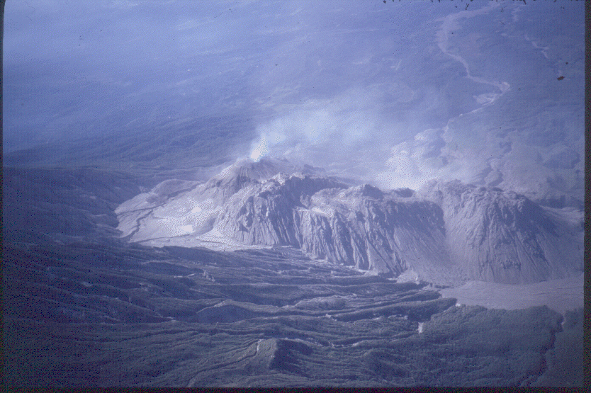
- Aerial view of Santiaguito and Santa Maria from the south. Photo by Bill Rose, March 1980.

- Aerial view, looking south at Santiaguito. The Caliente vent is to the left, with gas emissions, and the El Brujo vent is to the right. In between, an area of increased mass wasting along the north side of the El Monje dome can be observed. Photo by Sam Bonis, 1992.
2. End of Dome Extrusion
If dome extrusion stops, hazards will differ, but not disappear. Sedimentation below the dome would slowly decline. The possibility of block and ash flow would be removed and flooding dangers lessened. Collapse of a cold dome edifice is still a possibility. In this case debris avalanches might affect an area similar to Zone II, but perhaps somewhat less area.
3. Renewal of Plinian Activity:
Perhaps possible in view of the 1902 eruption, the scale of these effects are shown in another hazard map. This is based entirely on the 1902 eruption and the variability of local winds. An eruption of this scale does not generally occur with a frequency of more than 1/1000 years.

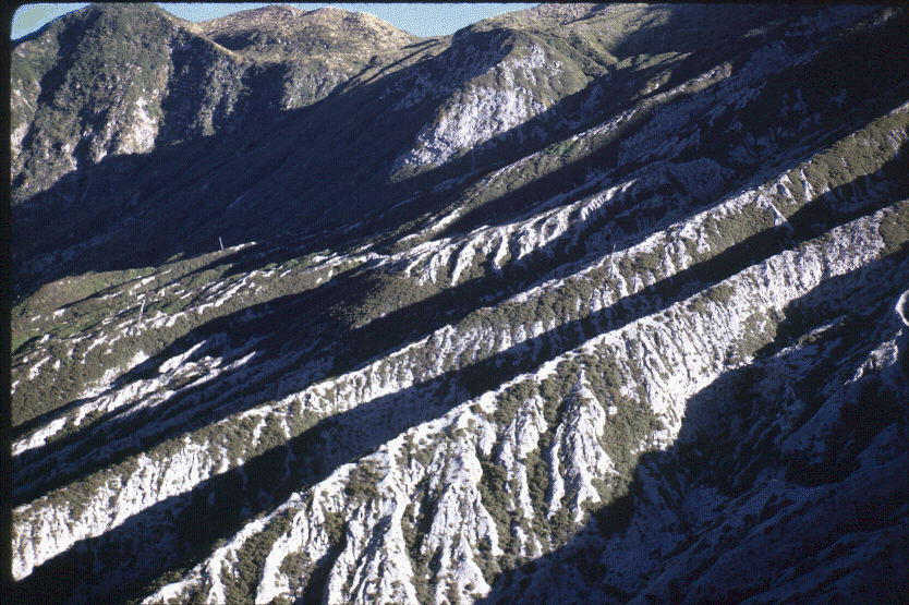
- View looking N from the summit of Santiaguito across the west slope of Santa Maria, showing the deeply dissected 1902 eruption deposits. Photo by Bill Rose, January 1970.

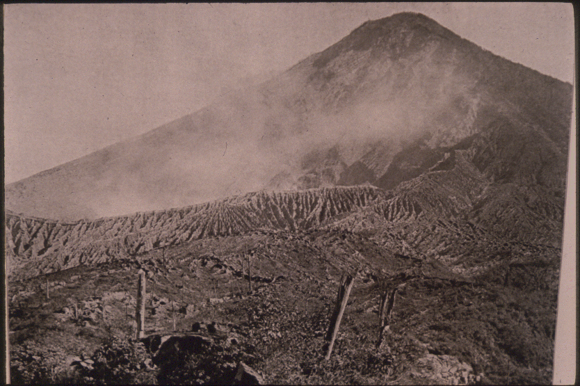
- Photo of the 1902 explosion crater of Santa Maria, as viewed from the south.
4. Renewal of Basaltic or Andesitic Activity:
The existence of basaltic admixtures in all Santiaguito and 1902 dacite suggest that Santiaguito could eventually be covered by a new basaltic andesite cone. This change would make a major difference in hazard assessment. Compositional studies of lavas should be made to anticipate this change. We do not know the likelihood of this.
5. Collapse of Santa María:
Because it is so highly oversteepened, it is highly possible that Santa María itself could collapse. This could result in a debris avalanche covering more than 100 km², most probably to the south or southwest. While statistically unlikely in the short term, such events must be mentioned in view of their gravity. A collapse of Santa María may be less likely as long as Santiaguito remains active because the focus of inflation during intrusion is not central to Santa María.

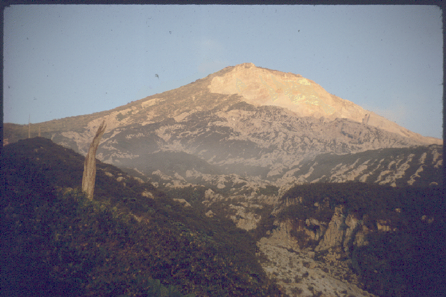
- The Santa María cone viewed from the foot of Santiaguito's talus apron about 1 km directly south of the 1902 crater. The inner face of the explosion crater is reflecting alpenglow, and the foreground views show the thick 1902 fall deposits with a few of the large 1902 forest trees still upright. Photo by Bill Rose, February 1970.

(Rose et al., 1989)