ERUPTION HISTORY
Prior to 1902, Santa María volcano was inactive for at least 500 to several thousand years (Rose et al., 1977).
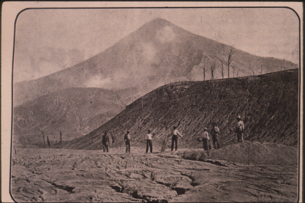
On October 25, 1902 Santa María erupted violently following a January-October series of earthquakes centered in the Central American-Caribbean region. These severe earthquakes and the extensive volcanic activity in the region were the unmistakeable indicators of the upcoming eruption. As there was no historical record of previous volcanic activity, these warning signs were not recognized. The Plinian eruption killed at least 5000 people (undoubtedly an underestimate) and tore a gaping hole in the south flank of the cone, and darkened the skies over Guatemala for days (Sapper 1903).The worldwide impact was significant, as ash was detected as far away as San Francisco, CA. Although deviations in temperature caused by stratospheric perturbations are essentially undetectable, this is probably due to the dacitic composition of the magma as opposed to the intensity of the eruption. (Williams and Self, 1983).

- Santa María, as seen from the south. Photo by J.M. Cardenas, November 1902.
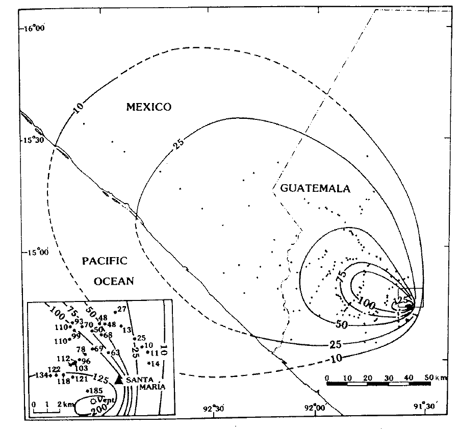
By far one of the largest and most explosive eruptions of this century (magnitude of 8 on the Tsuya scale), it produced a vertical column at least 28 feet high(Williams and Self, 1982). 10 km³ of dacite were erupted in a 36 hour period (Sapper, 1904; Rose, 1972; Williams and Self, 1983). The volcanic debris was almost entirely pumice deposit, deposited over 273,000 km² NW of the volcano. As is typical of widespread airfall deposits, the pumice deposit thickens toward the source, where it is 5 m thick (Williams and Self, 1983).

- Isopach map of the 1902 plinian deposit of Santa María Volcano. Inset gives detail near volcano (Williams and Self, 1983).
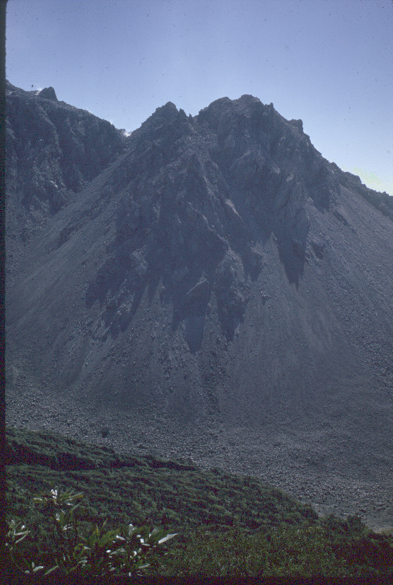
Following almost 20 years of repose, in June 1922 a volcanic lava dome began forming within the 1902 crater (Sapper, 1926). This new dome, located on the SW side of Santa María, was called Santiaguito. The dacite this dome extrudes is nearly identical to the lava of 1902. Santiaguito has been continuously active since its inception. Besides dome extrusion, which is relatively passive, Santiaguito has extruded lava flows, has had vertical explosive eruptions and has had numerous block and ash flows with accompanying pyroclastic surges. As a consequence of this, there is always avalanching near the dome and the 1902 crater and extensive sedimentation in rivers south of the dome(Rose, 1972).

- View, looking south, of the El Brujo Dome unit of Santiaguito from the descent trail south of Magermanns. Photo by Bill Rose, February 1970.
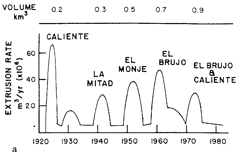
Santiaguito volcano, active for the past 62 yr, has produced almost 1 km³ of compositionally uniform, soda-rich, calc-alkalic dacvite lava that is preserved in 22 distinct extrusive units. The volcanic activity has consisted of endogenous extrusions, block-lava flows, Merapi-type block and ash flows, vertical pyroclastic eruptions, and lahars. Since 1960, block-lava flows have been volumetrically more important than endogenous domes, which were dominant in earlier periods. A 10-12-yr cyclic pattern of activity is marked by the laternation of 3-5 yr periods of high extrusion rates with longer periods of low extrusion rates. The most recent period of high extrusion rates (1972-1975) was marked by several large lava flows accompanied by large block and ash flows. During the high extrusion rate period, two distinct vents erupted. However, since 1977 only the Caliente vent, the principal vent at Santiaguito, has remained active. From 1975 through 1984, vertically directed pyroclastic eruptions were especially conspicuous. These erupted bread-crust blocks and locally dispersed fine phreatomagmatic ash. Since 1979, small Merapi-type block and ash flows have been erupted repeatedly from the toe of a small, 400-m-long block-lava flow that is being extruded from the Caliente vent and is flowing down a steep southern slope. On the basis of past behaviour, a new period of high extrusion rates is overdue. It may cause an increased extrusion rate for the block-lava flow, or it may result in the extrusion of a new lateral dome unit. At present, the most serious hazards are mudflows, which occur in each monsoon season and which affect areas more than 10 km from the dome. This problem is worsened by the mid-1970's shift of extrusion to the east side of the dome, which affects river valleys that have been resettled during the past 40 yrs. If the next expected high extrusion rate period focuses on the Caliente vent, as the trends now suggest, the hazard could increase markedly. The last extrusion rate maximum of this type, in 1929-33, resulted in very large block and ash flows that caused many deaths. (Rose, 1987)

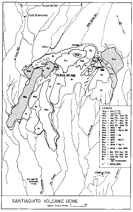
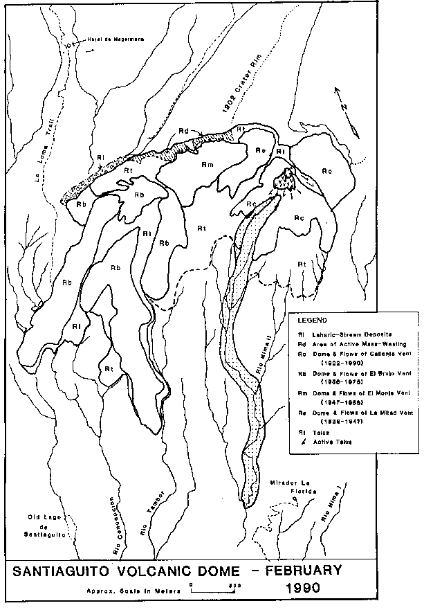
- Map of the individual units of the Santiaguito dome, showing individual units and the dates of their extrusion. The units extruded in the 1972-1975 spurt are shaded, and the locations of the El Brujo and Caliente vents are shown. Symbols used are consistent with previous papers (Rose, 1972b, 1973a; Rose and others, 1977a)(Rose, 1987).

- Plot showing the estimated variation of magma extrusion rates at Santiaguito as a function of time since 1922. The approximate volume of the dome complex at various times is listed above. Six extrusive spurts are shown. The spurts mainly associated with extrusion at a particular vent are labeled with the name of that vent. The sixth spurt was marked by extrusion at both the El Brujo and Caliente vents (Rose, 1987).

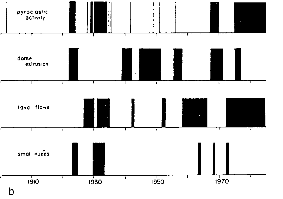
- Schematic representation of the timing of different types of activity at Santiaguito, without any attempt to show the relative scale of different types of activity (Rose, 1987).
Partial collapse of Santiaguito in 1929 produced pyroclastic ash and block flows which flowed more than 10 km to the south of Santiaguito. This devastating flow resulted in hundreds of deaths and extensive damage to villages and plantations (Sapper and Termer, 1930). The continued activity of Santiaguito has caused similar flows since 1929, but these are on a much smaller scale. Hence, little damage has incurred in populated areas.
On November 2, 1929 at 9:30 PM (local time) the Santiaguito Volcanic
Dome emitted a substantial (>1.5x10^7 m³) pyroclastic flow. It
extended more than 10 km with a vertical drop of 1800 m down the
valleys of the Rivers Nimá II and Tambor, devastating at least
15 km² and killing at least several hundred and possibly as many as
5000 people. River valleys were filled with block and ashflow deposits
and an intense hot pyroclastic surge was described by eyewitness a
major cause of deaths. Ash fell for 9 hours at Retalhuleu, 27 km from
the dome. The dome was marked by a large notch following the eruption,
suggesting the eruption was the result of collapse of the 350 m high
dacite dome which grew from 1922-1929. This collapse represents the
most hazardous event in Santiaguito's continuous 66 years of activity.
No unusual precursors were noted by local residents. The deposits of
the 1929 eruption have been mapped and described by field work in
February-April, 1988. It is a block and ash flow with abundant dacitic blocks (4 cm to 6 m diameter) set in a matrix varying from coarse to fine sand size. Thin sections and bulk chemical analyses of the blocks show they are similar to the dome rocks. The 1929 deposit is thinner and more hummocky where it is preserved between river valleys. The larger blocks are found between the river valleys, but outside of the hummocky areas. Hummocks are largely absent within the river valleys, but the discontinuously preserved deposits are thicker. Debris-free pockets are found within the devastated area, these are topographic highs and areas partially shielded by topography. From a hazard point of view, the partial protection made no difference, people within the pockets were killed by the hot surge. The hazards of such dome collapses are influenced strongly by topography, because the flows are guided by valleys. Surges affect areas near the dome and along the affected valleys, including topographic highs. Debris fills the river channels, damming and rerouting the rivers. This in turn results in widespread flooding and lahars. (Mercado et al., 1988)

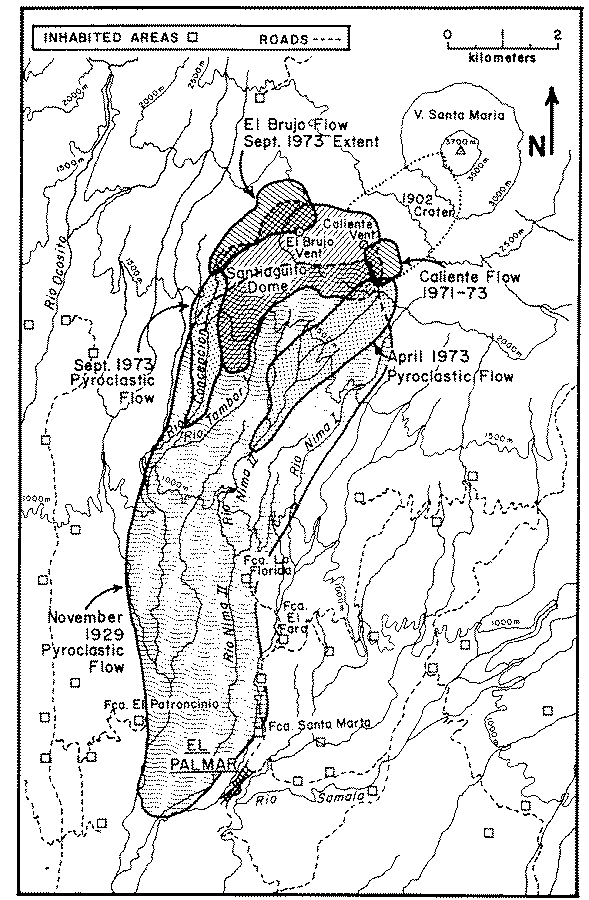
- Map showing the areas devastated by large pyroclastic flows at Santiaguito in 1929 and in 1973. The extent of lava flows in 1973 is shown by shading(Rose, 1987).

- Active block and ash flow and elutriated ash cloud from the Caliente vent area, July 19, 1989. This flow traveled about 4 km down the valley of the Río Nimá II. The photograph was taken from El Palmar, 10 km S of Santiaguito, by F. Michael Conway.
More recent activity (1975-present) is characterized by laharic sedimentation and small-scale lava flows, along with the activity described above. These extrusions have caused flooding and daming of regional rivers such as Río Nimá II and Río Samala. Current hazard studies concentrate on the consequences of this aspect of Santa María activity.

- Areas of Santiaguito which have been unusually active in recent years: Rd, Rl, active lava flow 1987-1991 (stippled), and Caliente Vent dome.