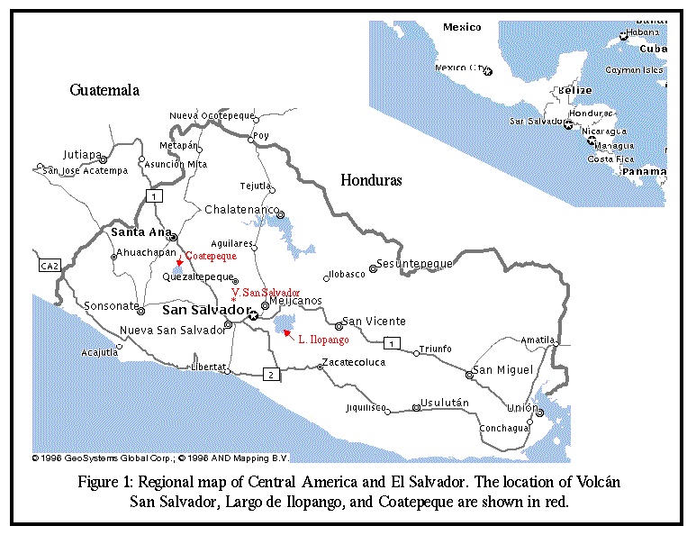
The capital city, San Salvador (pop. 2 million) sits in the shadows of a volcano with an impressive array of hazards. The volcanoes around San Salvador have not exhibited any volcanic hazard for four generations. Overpopulation has caused people to build higher on the flanks of the volcano, with little comprehension of the risks. Earthquakes (1986) and mudslides (1992) have been the main focus of environmental hazard concern. Historic activity of Volcán San Salvador includes summit pyroclastic eruptions, and crater collapse, as well as phreatomagmatic explosion craters, cinder cones, and lava flows along N40W striking faults on its flanks. The city is within the hazard zones of both the summit (1000 meters above and 7 kilometers away from the city's center) and the flank faults (traversing through a portion of the city itself), it is important for people to understand the possible hazards.
The goals of the work are; to collaborate with Salvadorian officials, to figure out the eruptive history of the volcano and its associated fissures, and to begin communication about the volcanic risks that Salvadorians face.
This poster presents the progress of collaboration with Centro de Investigaciones Geotecnicas, the Comision Ejecutiva Hidroelectrica del Rio Lempa, and Universidad de El Salvador. Together, we forged a working hypothesis of the historic activity of the region. A detailed geologic map was compiled. Samples were collected for analysis. And most importantly there is an agreement to take the information gathered from the work completed to publish and disseminate it to the public and officials within El Salvador.
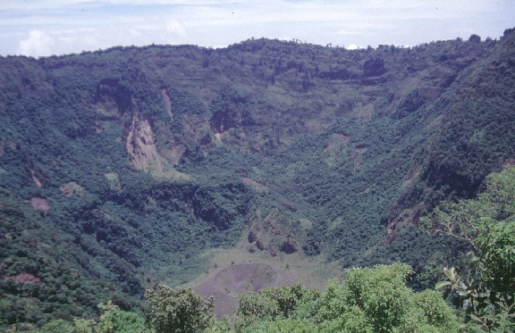
Photo of the inside of El Boqueron (the mouth) the younger crater of Volcán San Salvador.
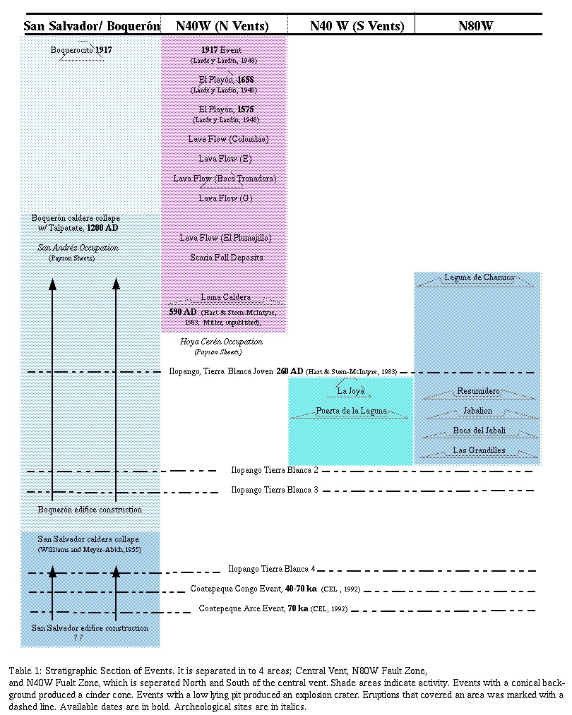
The volcano begins, with the construction of primary edifice. Lavas are found ponded against a graben fault. During construction there are plinian eruptions of Ilopango (Tierra Blanca 4) and Coatepeque. The first caldera collapse occurs producing a plinian andesitic ash fall deposit. A second edifice begins construction (Boquerón) while two more Plinian eruptions of Ilopango (Tierra Blanca 3 and 2) occur. Eruptive activity moves to the flanks with a combination of lava flows, cinder cones and hydromagmatic explosions deposits. A Ppinian eruption of Ilopango (Tierra Blanca Joven) blankets field area. Hydrated pyroclastic flow, `Talpetate" caps the western flanks of volcano, and causes multiple secondary landslides. Eruptions continue on the flanks, but there were no hydromagmatic eruptions after Talpetate. (Table 1)
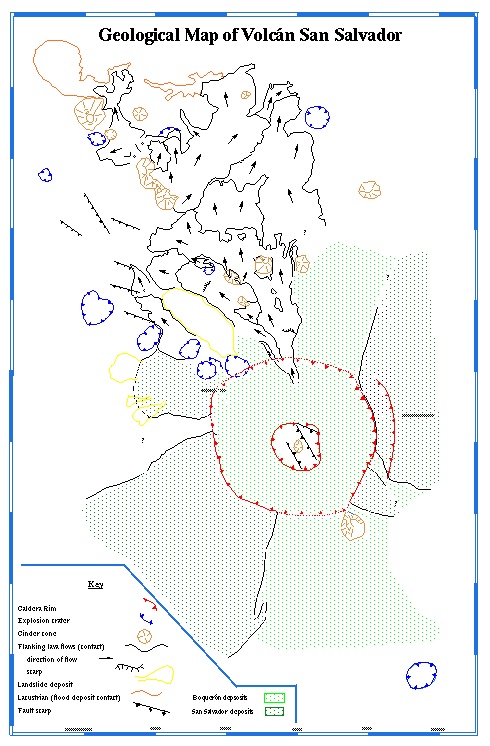
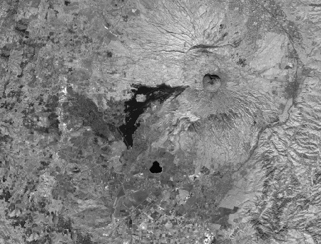
Williams and Meyer-Abich (1955) first proposed that Volcán San Salvador had two caldera collapses. A Landsat satellite can produce an image with a scale large enough to see the structures that they proposed (Figure 2b).
Landsat image show two rims, Boquerón inside of a less distinct older San Salvador caldera.
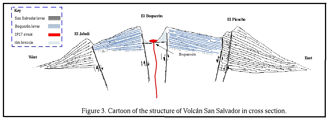
Jabalí and Picacho are remnants of the older caldera rim
Older lavas are more deeply eroded. Boquerón lavas breach the caldera rim to the North and Southeast.
Field observations support the visual evidence.
Differences in topography and morphology; older lavas are more deeply eroded than Boquerón lavas
Different stratigraphic sequences on El Picacho and near Nueva San Salvador.
An unconformity at base of El Picacho.
Figure 4. Cartoon of the structure of Volcán San Salvador in cross section.
N80W Trend
All activity along this trend has been hydromagmatic, resulting in explosion craters.
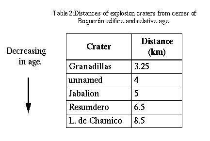
Activity over time has migrated further away from the Boquerón edifice. (Table 2)
Last eruption that formed Laguna de Chamico occurred between 260 and 1100 AD.
Could this fault zone include a graben that trapped groundwater facilitating hydromagmatic explosion?
N40W Trend
All of the eruptions along trend have been monogenetic.
Fault runs through the Boquerón crater.
Last eruption south of the edifice was more than 1700 years ago
The most recent activity is on the northwestern side of the volcano, furthest from the city of San Salvador and Nueva San Salvador (Santa Tecla).
Fault scarps of N40W trend can be found all over the central graben valley of El Salvador.
Figure 5: Photo of Laguna de Chamico, one of the youngest explosion
crater.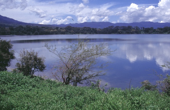
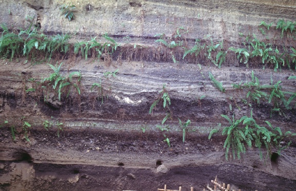
Hydromagmatic explosions may occur when magma interacts with groundwater. Rapid conversion of water to steam, causes a rapid increase in pressure. The explosion is the result from release of pressure. There are eleven hydromagmatic explosion craters in the field area.(Figure 5). The explosion were powerful enough to rip up the country rock (lithic clasts make up 20-80 percent of the deposits).
There has not been a hydromagmatic explosion in this area for over 900 years (Table 1). In fact there seems to be a shift from hydromagmatic eruption to lava extrusions on the flanks of San Salvador. The last ten magmatic events have been relatively dry; lava flow, cinder and splatter cones. (Table 1) The best hypothesis for the absence of hydromagmatic explosions in recent past is that the Talpetate deposit acts as an impermeable cap that reduces recharge of the groundwater aquifers. This would decrease the volume of water that interacts with the magma and prevents the explosive hydromagmatic eruptions. Talpetate is an indurated fine grain volcanic ash, that is appears to be impermeable, although no laboratory test for permeability have been completed. (Figure 6). It varies in thickness but was deposited over the majority of the active flanks.
Figure 6: Photo a Talpetate deposit, 5 meters thick near Finca Las Brisas.
Since the eruption of talpetate (~800 years ago), all the flank eruptions have been cinder cones and andesitic lava flows which are slow moving and are not a threat to life. The flows can destroy buildings and towns as well as bury productive corn fields or sugar and coffee fincas cover nearly the entire mountain. In 1650, El Playon lavas forced the relocation of an agricultral town,, Nejapa 6 Km to the east. Problems associated with relocation of a town would be compounded, today by the lack of available unused land.
Another hazard related to lava flows is damming of rivers. Historically, Río Sucio has been dammed twice (a result of El Playon and Tronadora Flows) The damming caused flooding upstream creating two lakes with a surface area of 1.1 and 2.7 Km2 respectively. There is also the possibility of flooding downstream, when the lava dam fails. There was no evidence suggesting that downstream flood occurred in these historical cases.
Field observations indicate that there has been 11 hydromagmatic explosions with in this field area. Two have occurred in the last 1700 years. These explosions were violent, explosively ripping up part of the earth as well as tossing hot juvenile magma away for the vent. Typically a crater remains, with meters of rocks deposited around it.
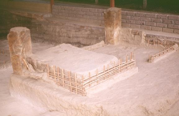
Deposits from the hydromagmatic explosions, that were exposed by the Cerén archeological dig.
The archeological cite, Hoya Cerén provides the best indication about the hazards of a hydromagmatic eruption in this area. In 1976, a bulldozer operator leveling ground uncovered a building covered in volcanic ash. Two years passed before, an archeologist Dr. Payson Sheet realized the importance of this discovery. The building was part of a peasant community of Mayans later found to be to be 1400 years old. Sheets and others have returned to the cite, and have unearthed a wealth of discoveries and deductions. Dan Miller, a USGS geologist has completed the most thorough survey the area. He determined the ash came for a hydromagmatic explosion crater a proximately 400 m. away from the cite. The village was covered by more than 4 m. of volcanic material. (Figure 8) Bed forms amd ramping of sediments suggest that the eruption was explosive and hurled material at a high velocity. Charred thatch and scorch marks on the dwellings suggest that the material was hot. The absence of human remains suggest that earthquakes or precursory eruptions warned the people to flee. Sheets suspects that the eruption occurred at night with little warning, because all the farm tools were found near the dwellings. Discoveries of domesticated animals, pots, and possessions suggest that the residence where in a hurry to father their things.
The size of the Loma Caldera (0.21 Km2) is small compared to the other explosion craters found on the flanks of San Salvador. (Figure4). Miller completed an isopach map of the tephra and found deposits more than 2 Km away. None of the other explosion craters have been studied as well as the Loma Caldera. La Puerta de la Laguna had the most extensive deposits, 0.5 meters of fine ash was found 4 Km from the center of its crater. In any case, it appears that a hydromagmatic explosion in this heavy populated region would effect people, dwellings, and crops.
The affect of an edifice collapse or central vent eruption historically can vary within orders of magnitude. But there were two historic eruptions of Volcán San Salvador worth mentioning. The largest, associated with the collapse of Salvador edifice has not been studied in detail, but field studies found deposits that were 1-4 meters 4km from the rim, and a thin tephra layer was found up to 18 kilometers away. The most recent event that produced a deposit informally called, Talpatate occurred around 1200 AD (Payson Sheets). A total area of 300 Km2 was affected by the deposit of an indurated ash layer at least 7 cm thick.(Hart, 1983) The west and northern flank of the volcano were most heavily effected. Closer to the vent the same event has the characteristics of a pyroclastic flow. One archeological site of ceremonial ruins, San Andrés was covered by the Talpetate deposits. Payson Sheets, believed that people where living in the Zapotitán Valley, but we are unsure of the effect this eruption had on their lives. If a similar eruption occurred today, thousands of people living in remote locations, as well as booming industrial areas might be covered in a meter or more of ash.
This region has been affected by many large earthquakes. The city of San Salvador was completely or practically destroyed during these years: 1576, 1659, 1798, 1839, 1854, 1873, 1880, 1917, 1919 (Lomnitz and Schulz 1965). In 1986 an earthquake killed 1500 people and made 100,000 homeless. There were many landslides of volcanic deposits. The hazards of earthquakes were magnified because of the thick unconsolidated tephra layers, and hasty construction on top of them. (Harlow, 1986) Three of these destructive earthquakes mentioned by Lomnitz and Schulz were associated with magmatic eruptions. All recorded eruptions (records go back to Spanish Conquest) have been preceded by an earthquake. An eyewitness of the 1917 eruption, Manuel Martinez said, 15 minutes after the first earthquake started, he began to see steam coming from Boqueron. These findings suggest that precursive seismicity may be useful to forecast magma movement or eruptions.
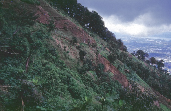
A secondary hazard are mudflows of eroded volcanic rocks or tephra which occur during the rainy season. Steep slopes of Picacho and Jabali as well as steep canyons west of Santa Tecla and northwestern San Salvador are common sites for mudflows. In 1992, a mudflow on the east slope of Picacho killed six. The best defense for preventing mudflows is to reforest slopes.
The steep slopes of El Picaho with the capital city, San Salvador in the background.
Gaps along the N40W trend that have no had a monogenetic eruptions. These are more likely to be a site of a vent than directly over an plugged vent. Low Lying areas were lava flows are more likely to flow
Areas prone to flood from a lava dam.
Barberi, 1985 Mecansimos de interaccion explosiva del magma con acuiferos subterraneos. In: Arana, V (Ed), Mecanismos eruptives y estructuras profundas se volcanoes Espanoles e Italiansos. Reunio Cientifica CSIC (Espana) CNR (Italia) Prog. No. 5: 13-23.
Burbach, G. V., C. Frohlich, W. D. Pennington, and T. Matumoto, 1984. Seismicity and Tectonics of the subducted Cocos plate. Journal of Geophysical Research 89: 7719-7735.
Carr, M. J. and R. E. Stobier, 1977. Geologic setting of some destructive earthquakes in central America. Bulletin of the Geologic Society of America 88(1):151-156
Carr, M.J., l984. Symmetrical and segmented variation of physical and geochemical characteristics of the Central American volcanic front. Journal of Volcanology Geothermal Research, v. 20: 231-252.
Fairbrothers, G. E. Carr, M.J., and Mayfield, D.G.,1978. Temporal magmatic evolution at Boqueron Volcano, El Salvador. Contributions to Mineralogy and Petrology 67: 1-9.
Fierstein, J., Nathenson, M., l989. Calculation of tephra volume using ln(thickness) - (area)1/2
plots. EOS, v. 70: 1412-1416.
Heiken, G. 1971 Tuff rings: examples from the Fort Rock-Christmas Lake Valley south central-Oregon. Journal of Geophysical Research 76:5615-5626
Finnson, C. B. H.,1994. Landslide hazard at the San Salvador Volcano. Royal Institute of Technology, Division of soil and rock mechanics, Department of civil and environmental engineering.
Harlow, D. H. and W., Randall. A1985. Shallow earthquakes along the volcanic chain in Central America: evidence for oblique subduction. Earthquake Notes 55: 58.
Harlow, D. H. W., Randall. A., Rymer, Michael J., and Alverez, Salvarez, 1993a. The San Salvador Earthquake of 10 October 1986 and its historical context. Bulletin of Seismological Society of America 83(4): 1143-1154.
Hart, W.J. 1983. W.J.E. Classic to Postclassic tephra layers exposed in Archeological sites, eastern Zapontitan Valley, in Archeology and Volcanism in Central America (ed. Sheets, P.D.) University of Texas Press, Austin.
Hart, W.J. and Steen-McIntyre, V. Terra Blanca tephra, in Archeology and Volcanism in Central America (ed. Sheets, P.D.) University of Texas Press, Austin.
Joyner, W. B., R.E. Warrick, and T.E. Fumal, 1981. The effect of Quarterary alluvium on strong ground motion in the Coyote Lake California, Earthquake of 1979. Bulletin of Seismological Society of America 71: 1333-1349.
Larde y Lardin, J.,1948. Genesis del volcan del Playon. Volcanologica Salvadorena, Revista del Ministerio de Cultura 7-24: 101-111.
Lomnitz, C. and R. S., 1966. The San Salvador Earthquake of May 3, 1965. Bulletin of the Seismological Society of America 56(2): 561-575.
Martinez, M. A., 1976. Importancia de la Geologia del Subsuelo en el Planeameinto Urbano. Universidad de el Salvador Facultad de Ingenieria y Arquitectura Oficina de Relaciones
Meyer-Abich. H, 1954 Los volcanes activos de Guatemala y El Salvador,Anales del Servicio Geologico Nacional de El Salvador 3: 67-70
Schidt-Thome, M. ,1975. The geology in the San Salvador area (El Salvador, Central America), a basis for city development and planing. Geol. Jb. B13: 207-228.
Sheets, P. 1994, Ceren Cite. Archaeology and Volcanism in Central America (ed. Sheets, P.D.) University of Texas Press, Austin: 30-33.
Stoiber, R.E., Carr, M.J., 1973 Quaterernary volcanic and Tectonic segmentation of Ceneral America. Bulletin of Volcanology 37 (3), 304-325.
White, R. A. a. Harlow, D.H. , 1973. Destructive Upper-crustal Earthquakes of Central America since 1900. Bulletin of Seismological Society of America 83(4):
Wohletz, K., 1983 Mechanisms of hydrovolcanic pyroclast formation: grain-size,scanning electron microscopy and experimental results. J. Volc. Geotherm. Res17:31-63
Wohletz, K. and Heiken, G.,1992 Volcanology and Geothermal Energy
University of California Press Publicas.
1988. Programma di Ricostruzione. Geotermica Italiana.
Hazards of a central vent eruption or an edifice collapse
Earthquakes and Mud Slides, and Heavy Rain
Hazards Zones
Area at rick to a Pyroclastic flow
Steep Sloping terrain that is prone to mud slides and landslides.
Major Population centers were many people work or live.
Resources