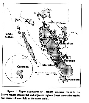
Activities: We made two trips across the Sierra Madre Occidental (SMO): from Mazatlán to Durango and from Chihuahua to Hermosillo. This Mother of all Mountain Ranges makes the Huron Mountains of Michigan look like "topes" or speed bumps. "The SMO is the largest continuous expanse of silicic volcanic rocks in the world" (Aranda-Gomez et al, 1997). The northern section begins north of Guadalajara and stretches northwest to the US Border (1200km). For 100's of kilometers there is no flat land only ridges, cliffs, and alluvial fans. Swift rivers cut deep into the thickest and most voluminous volcanic tuff deposit on earth. Barranca del Cobre, in the heart of the Sierra Madre, is considered the deepest canyon system in the world.
Background: The main outcrop of the SMO is a volcanic plateau (>1200 km long) that runs parallel to the Pacific coastline, from the U.S.-Mexico border (31 N) to the Trans-Mexican Volcanic Belt (21 N). Near the base of the plateau is exposed a thick (~1 km) Cretaceous to early Tertiary magmatic sequence (Lower Volcanic Complex) dominated by a granitic batholith and propylitically altered andesites. Resting atop the Lower Volcanic Complex, and separated by a major unconformity, is a thick succession of mid-Tertiary (30-40 Ma) felsic volcanic rocks dominated by ash-flow tuffs (Upper Volcanic Supergroup). Isolated exposures of similar volcanic rocks extend into the surrounding regions of the Basin and Range Province (BRP) and Gulf of California Basin (GCB) and produce a total aerial distribution of approximately 300,000 km2. The origin of the calc-alkaline rocks of the SMO is tied to the eastward subduction of the Farallon Plate along the western Cordillera of North America. By mid- to late-Tertiary (30-2.0 Ma) subduction gradually ceased and a broad zone of normal faulting, more than 3,000 km long, was developed in the western U.S. and in northern Mexico (i.e. the BRP). As a consequence of this change, the voluminous subduction related calc-alkaline magmatism was succeeded by small-volume eruptions of intra-plate alkali basalts and basanites. In northern Mexico the faulted area is split into two branches separated by the relatively unextended SMO block. West of the SMO is the faulted region bordering the Gulf of California and to the east is the Central Meseta. In the region between Durango and Mazatlan, the transition between compression and extension occurred at about 30 Ma and the earliest known alkaline basalts began to erupt at 24 Ma in the Rodeo area. A new period of faulting and associated volcanism occurred in the Rio Chico-Otinapa graben at 12 Ma. By the Pliocene and Quaternary (5.3 Ma to resent), basanitic magmas, which carried deep crustal and upper mantle xenoliths to the surface, were erupted both in the Meseta Central (Durango Volcanic Field) and in the Gulf of California area (Punta Piaxtla). (From Aranda-Gomez et al, 1997)
View of the Sierra Madre from a pit stop at road marker km 214. Photo by Carlos Pullinger.
Activities: Our first trip through the Sierra Madre Occidental from Mazatlán to Durango was less than perfect. Okay, "290 km of Hell". This long drive didn't allow us much time to stop and see the outcrops. The dizzying heights and hundreds of the switch-backs didn't help our morale. There were countless breathtaking views of some of deep canyons and rugged mountains. If we were to do it again I think we would take our time and make it a three day trip.
Our only geological stop during the day was at the bottom of a fantastic outcrop of an individually welded tuff. Darrell leans against the tuff sequence for scale. The basal surge layer and contact between eruptive events is the thin white unconsolidated unit about twenty feet above this head. Photo by Colleen Riley. Talk to Lenny about hand samples. Lesson: Here we learned about the typical depositional sequence for a single plinian eruption. The first deposit from an eruption is usually a basal surge layer. It is composed of a thin (>1 meter) unconsolidated, moderately well sorted, and sometimes stratified ash. On top of the surge deposit is an ash flow deposit that is often divided into sub-units; vitrophyre, welded, and vapor phase units. Ash flows are poorly sorted and commonly contain visible pumice fragments. An ash flow can be deposited as a very hot mass. The temperature and thickness of this deposit will dictate the presence and extent of these sub-units. The vitrophyre is typically at the base of a welded tuff. It is a glassy unit that is consolidated but not welded. The lower unit of ash quickly cooled and did not crystallize from the heat of the ash flow. Above the vitrophyre is the welded unit. Here the heat was substantial enough for the vitric ash to crystallize. Typically the pumices become compressed and elongated. This is the densest portion of the flow. The vapor phase unit is distinguished by a region where the glass in the pumices are dissolved by escaping gases. The result looks like a tuff of swiss cheese or rock with many voids or holes distributed throughout.
The asymmetrical bomb sag (to the right of Amanda's head) indicates the eruption occurred to the right of Amanda. Photo by Carlos Pullinger.
Background and Activites: El Jaguey and La Brená are the names of two maars north of the capital city of Durango. They are the only two maars that erupted in the Pliocene-Quaternary (1.6-5.3 Ma) in the Durango Volcanic Field. There were the first hydromagmatic craters we saw in our trip. Jim Luhr, a volcanologist suggested we do a mapping project there, and we were glad he pointed the maars out. The complex is made of the two maars whose deposits covered two or possibly three cinder/spatter cones and three lava flows. The pits from the explosion craters exposed the lavas and cones. One of the craters truncated the other. Our project was to find evidence for which eruption occurred first, make a stratigraphic column, and geological map.
Lesson: One thing we found was that the lava on the floor of La Brena crater contained xenoliths of crystal rich olivine. It is believed that they are parts of the upper mantle. By analyzing xenoliths like these, geologists have a better understanding of what material is deep beneath the earth's crust.
Darrell and Len search in a bedded surge deposit for clues about its origin (Photo by Colleen Riley). Here the types of clasts within the surge deposit can give a geologist an idea of the deposits that the explosion ripped up.
After a long day we found a great camp site at the base of these welded tuffs associated with the SMO. Our campsite was in the back of the canyon. Photo by Carlos Pullinger.
Location: Chihuahua City, Chihuahua, Mexico.
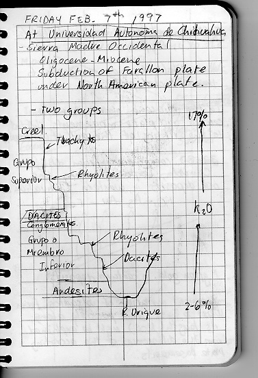
Activites: While at the Universidad Autonoma de Chihuahua we were given a lecture about the Sierra Madre that helped us to understand the time frame and geochemical trend observed in the massive assemblage of tuffaceous rocks.
Cross Section of deposits in the Sierra Madre Occidental from Creel (town near the edge of Barranca del Cobre) to Rio Urique. Notes from Carlos Pullinger. Lesson: The Sequence of events that formed the Sierra Madre Occidental can be described by this cartoon (above). The entire sequence was deposited from the Oligocene to Miocene (36-6 Ma). The magma for this region was generated by the subduction of the Farallon plate under the North American plate. In the Miocene (23-6 Ma), the plate movement ceased, eastward subduction and volcanism stopped. Extension began forming the fualted topography called basin and range. These extensional forces thinned the crust on the western side of the SMO which is thought to be the reason why magma surfaced in the Durango area during the Pliocene (5.3-1.6 Ma). The end of subduction correlates to the beginning of the rifting of the Sea of Cortez, which will be discussed in more detail in part 4 of the road trip.
This rugged terrain is the site of major mining exploration. Because of the lack of roads its wilds are now only beginning to be known. The roads we took are some of the only ones that cross the mountains.
Location: Hillside by route 16 approximately 200 km west of Chihuahua City.
Background: Here on the eastern most outcorps of the Sierra Madre
Occidental we began to see the complexity of ash flows in the rock record. At the first ash flow we visited (Mazatlán to Durango) we saw a single ash flow, that cooled independently from the one below it. It had distinct sub-units that were clearly recognizable. At Tomachi we saw ash flows that weren't so clear cut. Some units cooled together, forming indistinct contacts. There were mineralogical differences in the ash of the flows that indicated that the ash flows were from two different eruptive centers. And some of the subunits didn't form. Our instructions were to make a stratigraphic section from the deposits we found on the hillside and explain the geological history. Here is an example.
Location: The falls and canyon are part of the 14,300 acre Basaseachic Falls National Park. It is located just off route 16 or 305 km west of Chihuahua and 372 km east of Hermosillo.
Photo of the Basaseachic Falls and Barranca de Candaména by Bill Rose.
Background: The waterfall is the third highest in North America, 299 meters (980 feet). The water flow fluctuates between a small stream when we saw it, to a torrent river in the late summer. The water plunges into a breath-taking deep canyon (Barranca de Candaména) with walls that average 2000 feet high. The walls are composed of a single homogeneous ash tuff. Units of ashthat thick are only found inside the caldera where most of the erupted deposits come to rest. If this statement is true, then the unit is considered a intracaldera tuff. Little is know about this particular caldera and its deposits, but it is one of the estimated 350 calderas in the Sierra Madre Occidental (Swanson and McDowell, 1985).
The photos above and below show how the Rio Candaména has carved out a path through the jointed intracaldera tuffs. Jointing occurs as an ash tuff is cooling. Jointing propagates from the top of a deposit into the center, it facilitates the removal of gases and heat. Photos by Carlos Pullinger.
Location: Approximately 20 km west of Hermosillo, it is north of the Airport, west off of the road to Bahia Kino.
View from the top of the Cerro Bolo, vapor phase ash flow tuff in foreground.
Photo by Bill Rose. Background and Activites: With advice and leadership from Fransico Paz Moreno, a Professor at la Universidad de Sonora we went to Cerro Bolo for a stratigraphic mapping project. Cerro Bolo is a rocky hill that stands above the flat plains in and around the city of Hermosillo. The outcrops were exposed by extensional faulting. We saw a dacitic volcanic breccia overlain by alkaline lava flows. This lava was localized but overlain by a welded ash flow tuff 50+ meters thick. The ash flow was unique in that proportionally it had a very thick vapor phase zone.
Location: About 30 mile south of Hermosillo, it is west of route 15 to Guaymas.
Background: Francisco Paz Moreno, two students from the Universidad de Sonora, and the rest of our group drove up an access road to a Microwave Tower on the top of Sierra Libre. The top had a nice view of the basin and range mountains south of Hermosillo. The road had an outcrop of massive flow-banded rhyolite with huge spherulites and complexly folded fall deposits. See Darrell or Len for hand samples.
Click here to continue the Road Log to Part 4: East Pacific Rise and deposits on the Baja.
To the return to the Homepage
Drive from Mazatlán to Durango: Day 24, Feb 5th
El Jaguey-La Bren á Maar Complex: Day 25, Feb 6th
Universidad Autonoma de Chihuahua: Day 26, Feb 7th.
Tomachi Tuffs: Day 27, Feb 8th
Basaseachic Falls and an intracaldera tuff: Day 28, Feb 9th
Cerro Bolo Project: Day 31, Feb 12th
Sierra Libre: Day 33, Feb 14th