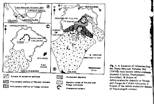
Figure 1, from Nelson and Herge, 1990.
This is a descriptive road log of Michigan Tech's 1997 Volcanology Field Trip to Mexico. The Drive started in Houghton, MI and went as far south as Colima, Mexico. This is accompanied by a map and home page.
Day 1, Jan 12th: Houghton to Nebraska
Day 2, Jan 13th: Nebraska to Albuquerque, NM
Day 3, Jan 14th: Albuquerque, NM to Holbrook AZ
Day 4, Jan 15th: Holbrook AZ to Jon Fink's house in Phoenix, AZ (Unfortunately , a scheduled field trip was cancelled by a snowstorm delay in Flagstaff.
Day 5, Jan 16th: Phoenix, AZ to Hermosillo, Sonora
Day 6, Jan 17th: Hermosillo, Sonora to Mazatlán, Sinaloa
Day 7, Jan 18th: Mazatlán, Sinaloa to Puerta Vallarta
The Conference gave some people their first professional meeting experience. Some of us presented our own work. We all learned from the wide range of talks and presentations about all facets of volcanology.
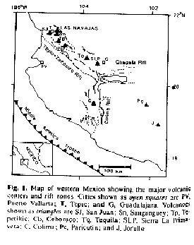
Background: The Western Trans-Mexican Volcanic Belt (WTMVB) is one province in the Trans-Mexican Volcanic Belt (TMVB), which is an andesitic continental volcanic arc. It is about 1200 km long and runs from the mouth of the Gulf of California across central Mexico through the Los Tuxtla area and ending at El Chichon volcano where it is linked to the Central America Volcanic Arc. Volcanoes of the TMVB result from subduction of the Cocos and Rivera plates beneath the North American plate along the Middle American Trench. The TMVB consists of three distinctive provinces choosen for their tectonic, volcanological and petrological characteristics. These zones are: 1) the western TMVB, dominated by the Colima-Chapala-Zacoalco triple junction where both alkaline and calc-alkaline volcanic products are present, 2) the central TMVB, characterized by huge andesitic stratovolcanoes, which form an E-W trending volcanic chain through central Mexico an dis dominantly where calc-alkaline volcanism and, 3) the eastern TMVB, including El Chichon volcano and Los Tuxtla areas which are sodic-alkaline volcanoes.
The western Trans-Mexican Volcanic Belt (WTMVB) includes three regional graben structures: The Colima Graben, The Chapala Graben, and The Zacoalco Graben. These three structures intersect about 50 km SSW from Guadalajara. The main TMVB axis, which contains andesitic composite volcanoes, is located along the Tepic-Zacoalco Rift about 200 to 230 km from the trench (Lange and Carmichael, 1991). Within the WTMVB two tectonic regimes are superimposed: aseismic subduction of the Rivera Plate beneath Mexico (Nixon, 1982; Burbach et al, 1984; DeMets and Stein, 1991) and rifting along the Colima Graben (Luhr et al,1985; Luhr et al, 1989).
The Colima, Zacoalco, and Chapala grabens come together at a triple junction which appears to mark an eastward jump of 550 km of the East Pacific Rise segment located between the Rivera and Tamayo Fractures Zones and the Colima Graben site. If this is the case, the Colima Graben eventually will develop into a spreading center, the Chapala Graben will become an aulacogen, and the Zacoalco Graben will become a right-lateral fault zone. The Colima and Zacoalco rifts (Allan et al, 1989) will eventuallyseparate the Jalisco Block from the Mexican mainland and the Pacific Plate (Luhr et al, 1985; Allen et al, 1989).
This complex tectonic framework has generated contemporaneous calc-alkaline and alkaline volcanism during the last 4.6 m.y. in the Colima Graben area (Allan, 1986). Similar volcanism occurred outside the Colima Graben but within the Jalisco Block during the last 3 m.y. (Wallace and Carmichael, 1989; Lange and Carmichael, 1991).
A lamprophyric volcanic belt located about 40 to 50 km trench-ward from the TMVB has been recently described near the towns of Mascota, Los Volcanes, and San Sebastian (Wallace and Carmichael, 1989; Lange and Carmichael, 1990; Lange and Carmichael, 1991). These authors suggest that the emplacement of potassic lavas on the Jalisco Block is the direct consequence of extension in the Tepic-Zacoalco and Colima rifts. The Colima Volcanic Complex within the Colima Graben is offset 90 km to the south of the main TMVB axis. (Sheridan and Macias, 1992)
Our tour of the WTMVB took us to volcanoes along the Colima and Zacoalco Grabens as well as the Michoacan-Guanajuato Volcanic Field (just east of the Colima Graben). The young volcanoes we visited in detail (Colima and Ceboruco) are calc-alkaline and are associated with subduction of the Rivera Plate under the North American Plate. Volcán Las Navajas and other portions of the Sangangüey region are alkaline and are associated with extension or rifting. We also visited Volcán de Paricutin, a cinder cone in the Michoacan-Guanajuato Volcanic Field which erupted only about 50 years ago.
East side of Fuego de Colima, by Carlos Pullinger
Location: 19.514N 103.62W
Background: The complex is made of two stratovolcanos, the dormant Nevado de Colima (Colima with snow), elevation of 4,200 m and the active Fuego de Colima (Colima of Fire), elevation 4100 m. The volcanos are steep sloped, heavily vegetated and uninhabited. However, at their base is the heavily populated, fertile, and prosperous state of Colima. From the capital, Fuego de Colima is in full view to the north. Nevado de Colima is 5 km further north from Fuego de Colima in the neighboring state of Jalisco.
Volcanologists believe this volcano is a threat to the capital, Colima. The capital sits on multiple layers of thick volcanic deposits. (Figure 1: Shows the extent of debris deposits from Volcán de Colima (from Robin et al., 1990).Colima Volcanic Complex: Days 15-18, Jan 26-29:
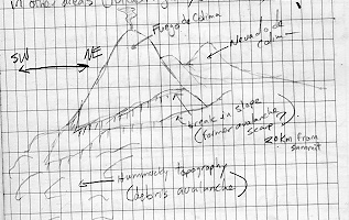
James Luhr first noticed that Fuego de Colima has a cyclical history of lava extrusion and cone growth followed by an explosive eruption and/or cone collapse. Colima's last large explosive eruption occurred on January 20, 1913 and it is currently constructing its cone again. This cycle historically averages about 70 years in length, which makes it about due. Because of its activity and threat to the people of Colima, Fuego de Colima has been listed as an IAVCEI Decade Volcano. Currently, an observatory monitors the activity of the volcano with seismographs to warn people of potential danger.
Our Activities: Our first post conference trip was the Colima Volcanic Complex, which is about 200km southeast of Puerto Vallarta. We had a long drive and we didn't arrive in the capital Colima until after dark and couldn't really see the volcanoes. Most of the people on our trip had never seen an active volcano and did not know what to expect. The next morning, we were taken by how massive and steep Fuego de Colima was.
We spent the first days looking at the different types of deposits (block and as flows, pyroclastic flows, lavas, and debris avalanches) around the base of the volcano. One day we visited the Centro Universitario de Investigaciones en Ciencias del Ambiente. Dr. Ignacio Galindo showed us the department and its labs. They have been using AVHRR and weather stations to see if and what kind of weather an active volcano creates. The next day we visited a state archeology museum. (Most of the archeological digs in this area remove volcanic deposits to uncover the artifacts of previous civilizations.) Then we hit the coast to make models of volcanos in the sand. Colima's beaches are composed primarily of volcanic sand that was eroded from the Volcano 80 kilometers upstream.
The last day in Colima, a master's student at the university, Alejandro helped us get to the saddle between the dormant Nevado and active Fuego de Colima. At the saddle, we split into groups: some helped Alejandro service a meteorological tower located on a flank of the volcano, while others looked at an active andesitic lava flow and learned some basics about how a Global Positioning System (GPS) can aid in field mapping.
Other Websites: There are a number of good websites related to Volán de Colima. We used, the Field Guide to Colima Volcano by Sheridan and Macias. It has a good introduction to the western Trans-Mexican Volcanic Belt (TMVB), the Colima Graben, and the geology/history of the Colima Volcanic Complex, as well as a summary of potential hazards. Unfortunately we found the guide had vague directions to the outcrops.
More information on Colima can be found on Volcano World's and Nasa's webpages. CARDI at the Geophysical Institute, (Universidad Nacional Autonoma de Mexico; UNAM) has a Landsat image of Colima that is worth the downloading time.
Volcán de Paricutin and associated lava flows, photo by Colleen Riley
Location:19.5N, 102.2W, 250km SE of Guadalajara
Elevation: 10,400 feet (3,170 m)
Background: Paricutin is better known as the volcano born in a Mexican corn field. You may have seen a picture of the volcano in an old Life or National Geographic magazine. In short, this cinder cone is the youngest in a large field of 10,000 cinder cones, called Michoacan-Guanajuanto Volcanic Field. In 1943 a fissure broke open the earth in a native mexican's cornfield. Over the next 9 years a cinder cone formed (336 meters high) and lava flows were extruded which covered two towns and land once farmed by thousands of Native Mexicans. This eruption unique since it is one of the only cases where the entire growth sequence of a volcano was well documented. An intriguing book, "Paricutin: The Volcano Born in a Mexican Cornfield" by James Luhr and Tom Simkin explains the history and the volcano's effect on the region's Native Mexicans, hydrology, and fauna.
Joanna and Seth walking in a stream channel and in front of eroded airfall deposits from Volcán de Paricutin. Photo by Carlos Pullinger
Activities: We camped at a modest tourist center with a great view of the volcano. It is located just outside of the Native Mexican village of Anghuan. The first day we hired a guide and hiked through the vast lava flows to the top of the prominent cinder cone of Paricutin. Bill Rose lectured on the sequence of events of the new eruption and the distribution of airfall deposits. We saw many types of lava flow structures including; lava levees, pressure ridges, aa blocks, and pahoehoe flows. After reaching the summit, we circled the lava flows (on the sand-sized airfall ash deposits) to the site of the abandoned town of San Luis Parangricutiro. There we saw a church that withstood the advancing lava. The lava flowed around and into the church, while covering, 3/4 of the town. The next day we worked on a "pace and compass" map of the town's remaining walls and lava flow contact.
Church of San Luis Parangricutiro with Volcán de Paricutin in the background, photo by Bill Rose.
Lesson: An eruption of andesitic magma generally begins with explosive ejecta. Paricutin, like other volcanoes began its eruption by violently ejecting blocks, lapilli, and cinders of magma that formed a cone. The cone in the pictures above was formed in the first year. After a period of time the activity shifted away from explosive ejecta to more passive lava extrusion. At Paricutin, lava continued to flow out of vents and over the surrounding land eight years after the cone construction had stopped. Scott Rowland has put together a slide show of the depositional evolution of Paricutin.
Website:
Driving tour from Paricutin to Volcán de Ceboruco through the Guanajuato-Michoacan Volcanic Field: Day 22, Feb 2nd
We started near Paricutin in the heart of the Guanajuato-Michoacan Volcanic Field (GMVF). There are approximately 10,000 volcanic cones of different sizes and shapes and therefore different ages (Connor,1987). As we drove east to Zamora (the strawberry capital of Mexico) we observed a gradual transition of volcano morphology in the GMVF, from cinder cones to shield volcanos. This reflected a change in the composition of magma and volcanic processes. Shield volcanoes are composed of less evolved magma than the magma that forms cinder cones.
We drove NW on Route 15, through Gaudalajara. La Primavera Caldera is north and west of the city. Although we choose not to stop, we could see some of the caldera's rhyolitic domes from afar. (Mahood, 1981)
Marcia looking at the Tequila banded rhyolite flow, photo by Colleen Riley.
Next in the chain of volcanic features was Volcán de Tequila. Tequila actually means sharp rock. It was named after the outcrops of obsidian near the town bearing the same name. This region of Jalisco is perfect for growing the succulent plant agave azul or "blue agave." The town of Tequila is where much of the agave is mashed and distilled to make the alcohol. We stopped at a banded rhyolite flow along the highway. It is called a banded rhyolite flow because; 1] it has a chemical composition of a rhyolite (Si02 >72%) 2] the visible banding is caused by micro shearing of the viscous rhyolite glass as it flowed from a vent. The banded rhyolite flow contained spherulites (ball like nudules) caused by partial devitrification of the flows. Some of us cut our hands on the sharp hydrated obsidian while knocking off pieces. This was our first "cool rock" collection locality. So we celebrated that night with that tasteful ``water'' from Tequila.
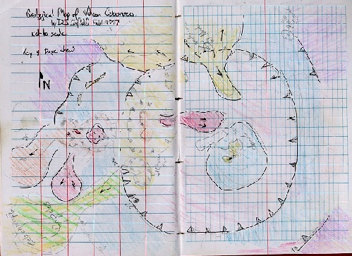
Geological Map of Volán Ceboruco, by Darrell Sofield
Location: 120 Km WNW of Guadalajara, in Nayarit along the Tepic-Zacoalco Rift. 21.145N 104.50W
Elevation: 2164m
Activities: Volcán de Ceboruco was one of the gems of our trip. This was a perfect example of a convergent plate boundary volcano and a gorgeous place for a mapping project. Ceboruco rises about 1000 m above its base. There is a well maintained cobble access road that heads out of the town of Jala to a microwave tower. The road starts east of the volcano, cuts some of the younger plinian fall deposits and lava, then wraps clockwise around the volcano to the west and to a breech in the crater wall. We chose a camping site in the moat between the andesite crater and the dacite dome. What a perfect spot to see the stars. With some help from the petroleum industry we got a fire going. The next day we set off to figure out the mysteries of the volcano. Below is what we found out about the volcano's history.
Small plug dome on the southwestern side of Volcán de Ceboruco. Photo by Bill Rose.
History: Activity at Ceberuco began with the build up of an andesitic lava edifice. Lava was fed by radiating dikes that can be seen in the present caldera wall. There was a period of repose when weathering was the dominant process and formed a thick paleosol which separates the youngest lavas. Soil erosion has made deep barancas around the southern side of the edifice. Approximately, 1000 years ago the volcano reactivated erupting a plinian pumice fall and subsequent pyroclastic flows in a westerly direction. The air fall (Jala Pumice) had a northerly dispersal axis. The edifice subsided forming a caldera, which collapsed on the western side. A dacite dome (Dos Equis Dome) formed in the center of the andesitic caldera which also collapsed. Rim dikes fed an andesite flow to the north (El Norte Flow). On Feb 22nd, 1870 the west side of the volcano became active. Cinder cones, flows, and domes formed. Today, hydrothermal fumaroles continue to emit steam. (Nelson and Sanchez-Rubio, 1986)
Click here to see one of the maps and time scales that were made.
View to the west from on top of Ceboruco. In the foreground is the remains of Ceboruco's crater wall and part of the El Norte lava flow. On the horizon is Volcán de Tepetillic (right), Volcán de Sangangüey (middle), and Volcán de San Juan (left). Photo by Bill Rose.
Location: 30 km NW of Ceboruco in Nayarit, Mexico along the Tepic -Zacoalco Rift.
Volcán Las Navajas is in the background as we (Darrell, Marcia, Joanna, Bill, and Lenny) try to comprehend the size of a caldera. Photo by Colleen Riley.
Background: This area includes a wealth of volcanos and volcanic deposits. The history is unclear until the Pliocene, when a suite of alkaline lavas began to fill the floor of the NW trending basin. The lava was concentrated in one area and resulted in the formation of a basaltic-trachytic shield volcano, Las Navajas. Las Navajas evolved to erupt comenditic and pantelleritic rhyolite ash flows and lavas. About 200,000 years ago activity ceased at Navajas and calc-alkaline lavas began to erupt south of Navajas, producing the Sangangüey cone. Currently dormant, Sangangüey has a resilient central stock sticking out above the rest of its eroding cone. Alkaline lavas and cinder cones continued to erupt in a NW linear fashion south of Sangangüey up to about 1000 years ago (Ferrari et al., 1997).
View of Volcán de Sangangüey from the southeast. Photo by Carlos Pullinger.
Activities: We visited one of the younger alkaline cinder cones which was altered (palagonitized) by water. We also visited an outcrop of the pantelleritic rhyolite lavas from las Navajas. Finally, we looked at some of the structural features of a caldera collapse and magma resurgence.
While in the Sangangüey region we camped on the shore of Laguna de Santa Maria del Oro, which appears to have formed in Miocene ash-tuffs (Ferrari et al, 1997). The age of the crater formation is not known, but it created a beautiful lake with great tasting fish and friendly locals.
To continue with Part 3 of the road log (Sierra Madre Occidental and extensional volcanism) click here.
Or to return to the Homepage click here.