Terascan XVU Commands: Select Locations and Select Point List
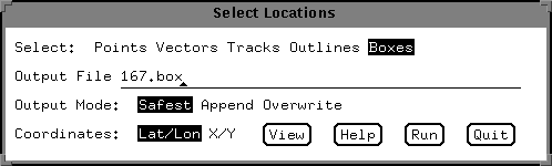
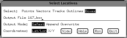 Now
that the data file has been registerd, and the volcanic cloud
identified, the data values can be subset for use in the volcanic
cloud retrieval. The first step is to select the general region of
the volcanic cloud. This is done using the Select/Locations function.
If you choose this, a window like the one on the right appears.
Select an output filename, whether you want the region to be a box or
an outline, and make sure that the lat/lon coordinates are select on
the bottom. First click "run" button
Now
that the data file has been registerd, and the volcanic cloud
identified, the data values can be subset for use in the volcanic
cloud retrieval. The first step is to select the general region of
the volcanic cloud. This is done using the Select/Locations function.
If you choose this, a window like the one on the right appears.
Select an output filename, whether you want the region to be a box or
an outline, and make sure that the lat/lon coordinates are select on
the bottom. First click "run" button
To define a box, click with the
left mouse button, and drag the window over the desired region, hit
the middle button to anchor the window, and then the right button to
write the file.
To define an outline, click around the perimeter with the
left button, close the polygon with the middle button, and hit the
right button to write the file.
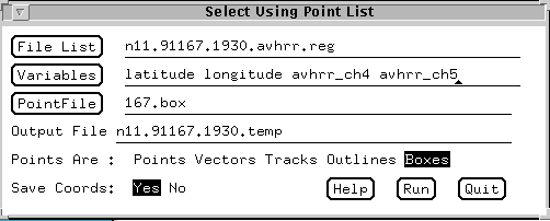 Now
that the location is selected, subset the point in that region using
the Select/Point List function of xvu. Select the filename
(registered TDF file), variables to be output (in this case,
latitude, longitude, achrr_ch4 and avhrr_ch5) and the name of the
point file (box or outline file). Specify the output filename, and
whether the point file is an outline or a box. Finally, answer yes to
the save coords question. Once this is done, the data file is ready
to be exported out of Terascan and into the volcanic cloud retrieval.
Now
that the location is selected, subset the point in that region using
the Select/Point List function of xvu. Select the filename
(registered TDF file), variables to be output (in this case,
latitude, longitude, achrr_ch4 and avhrr_ch5) and the name of the
point file (box or outline file). Specify the output filename, and
whether the point file is an outline or a box. Finally, answer yes to
the save coords question. Once this is done, the data file is ready
to be exported out of Terascan and into the volcanic cloud retrieval.
This page maintained by Dave
Schneider (djschnei@mtu.edu)
 Now
that the data file has been registerd, and the volcanic cloud
identified, the data values can be subset for use in the volcanic
cloud retrieval. The first step is to select the general region of
the volcanic cloud. This is done using the Select/Locations function.
If you choose this, a window like the one on the right appears.
Select an output filename, whether you want the region to be a box or
an outline, and make sure that the lat/lon coordinates are select on
the bottom. First click "run" button
Now
that the data file has been registerd, and the volcanic cloud
identified, the data values can be subset for use in the volcanic
cloud retrieval. The first step is to select the general region of
the volcanic cloud. This is done using the Select/Locations function.
If you choose this, a window like the one on the right appears.
Select an output filename, whether you want the region to be a box or
an outline, and make sure that the lat/lon coordinates are select on
the bottom. First click "run" button