VAR: Radius-Optical Depth Plots
Why is this plot important?
Using the refractive index numbers for water and volcanic ash,
examples of each type of cloud can be simulated using
the radiative transfer model of Wen and Rose [1994]. The relationship
between the band 4-5 temperature difference and the band 4 temperature
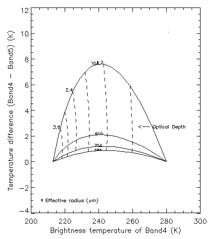
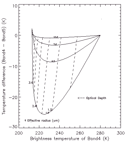
over a range of cloud particle sizes and optical depths are shown below.
In these plots, the envelop formed by the radiative
transfer model converge at two band 4 boundary conditions; the
temperature at the top of the cloud (Tc=215 K), and the temperature of the
surface underlying the cloud (Ts=280 K). The continuum of optical depths
extend from opaque (Tc) to transparent (Ts). Transparent
meteorological clouds, composed of water droplets or ice
particles (left), have a characteristic concave up form,
indicating a positive band 4-5 temperature difference, while
transparent volcanic clouds (middle)
have a convex up form, indicating a
negative band 4-5 temperature difference. These scatter plots form
the basis of the retrieval of the cloud properties.


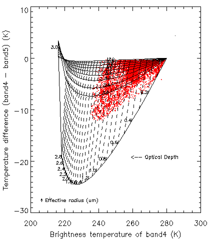
The retrieval of the ash of volcanic ash using the technique of
Wen and Rose [1994] is accomplished in several steps: 1) The
radiative transfer equation for a scattering, plane-parallel volcanic
ash cloud is solved at a series of effective particle radii (1 to 10
microns radius: shown above as the solid lines), and optical depth values
(from 0 to 3: shown above as the dashed lines). Note that the
theoretical values converge at 215 K, the temperature totally opaque
region of the cloud and 280 K, the temperature of the surface
underlying the transparent cloud. 2) The mean particle size and mean
optical depth of each pixel is determined by comparing the theoretical
curves to actual pixel values (shown above on the right as the
red dots). Each pixel is assigned an optical depth and effective radius
value based on its proximity to each of those lines. In effect, the
data are being put into "bins". 3) The mass of silicate ash in each
pixel is determined by multiplying the volume of ash in each pixel from
size and optical depth retrievals) by an average ash density (2.5 g/cm3).
 The first step in doing a volcanic cloud retrieval is the production of the
radius-optical depth plot. This plot illustrates whether the boundary conditions
of the model have been set correctly, and whether the volcanic cloud is underlain by a uniform background. The processing sequence is:
The first step in doing a volcanic cloud retrieval is the production of the
radius-optical depth plot. This plot illustrates whether the boundary conditions
of the model have been set correctly, and whether the volcanic cloud is underlain by a uniform background. The processing sequence is:
- Select Radius/Optical Depth from the VAR Simulation Model menu
- Select the proper choice from the Ash/Aerosol Material Properties menu.
For ash, we typically use the Andesite values of Pollack
- Use the default (BTD Grid Retrieval) for the submodel
- The optical depth model is typically used
- The log normal particle distribution is typically used
- Set the appropriate Cloud Top Temperature and Cloud Base Temperature.
See below for more information
- Save the case, and then run it.
- Plot the results, and overlay the AVHRR Pixel data on top of it.
- Repeat steps 6, 7, and 8 if necessary to improve the selection of the
boundary conditiions
The last parameter to set is the number and range of the effective
radii levels, and the number and increment of the optical depth levels.
These values determine the density of the retrieval grid. The retrieval code
assigns each pixel to the nearest effective radius and optical depth value,
(shown in the ROD plots above). The greater the number of lines, the finer
the grid. Maximum values for the levels are about 100. For clouds with a
low optical depth, the delta x value may have to be reduced to about 0.01.
Setting the Temperature Boundary Conditions
 As you can see in the example shown above, the AVHHR data converge
naturally towards the Cloud Base boundary condition. A typical retrieval
involves making an intial guess at the cloud base temperature, based on
examination of clear pixels near the edge of the volcanic cloud, and
then adjusting the cloud base temperature until the envelop
converges with the observed values. It is a bit of a judgement call to
be sure.
As you can see in the example shown above, the AVHHR data converge
naturally towards the Cloud Base boundary condition. A typical retrieval
involves making an intial guess at the cloud base temperature, based on
examination of clear pixels near the edge of the volcanic cloud, and
then adjusting the cloud base temperature until the envelop
converges with the observed values. It is a bit of a judgement call to
be sure.
Setting the cloud top temperature is also a bit of an art form. There
are several ways to do this.
- If there is a satellite observation of the eruption cloud
made while it is still opaque, the brightness temperature of that
portion of the cloud can be used. If no other observation is available,
this value is kept constant in subsequent retrievals, as the cloud disperses.
- If wind data is available, and the conditions are favorable, it may
be possible to get a cloud height based on the azimuth of movement and/or
the speed of cloud movement. Once a height is obtained, it can be related to
an atmopsheric temperature profile.
This page maintained by Dave Schneider (djschnei@mtu.edu)