The new generation of imagers, currently aboard GOES-8 (centered at 75 W) and GOES-9 (centered at 135 W) have several significant improvements for the detection, tracking and measurement of volcanic clouds. Imager data are now collected simultaneously in five spectral bands (0.52-0.72, 3.78-4.03, 6.47-7.02, 10.2-11.2, 11.5-12.5 microns), at higher spatial resolution (4 km for the thermal channel at the sub-satellite point), and are available as frequently as every 15 minutes. This paper reports on a test of GOES imager data to detect and discriminate volcanic clouds. Twenty-two GOES-8 images of a minor ash emission event from Popocatepetl Volcano, Mexico (March 10-11, 1996) were analyzed using a two band technique, and the results show that it is possible to detect small volcanic clouds using GOES. The mass of airborne volcanic ash was retrieved from the GOES data using a slight modification of the technique developed by Wen and Rose [1994] for use with AVHRR. The frequency of the available imagery allow for detailed observations of the eruptive activity of the volcano.
On March 5, 1996, a small explosion cleared the vent, and between that time, and the period covered by the satellite observations presented herein, the activity was characterized by a number of small, continuous ash emission events. These ash emission events typically lasted for several hours to tens of hours, and were accompanied by continuous tremor, which has been interpreted as high-speed exhaust of volcanic gases that remobilize non-juvenile ash (Smithsonian Institution, 1996). On March 7, 1996, the tremor amplitude and duration increased to levels exceeding those of December 1994, and persisted until 2000 UT on March 10, when it slowly decreased until its end at 2110 UT. (Smithsonian Institution, 1996). The seismic activity continued at low levels until 0000 UT on March 12, when continuous tremor resumed. The satellite observations in this paper are of the end of continuous tremor, and the subsequent low-level seismic activity.
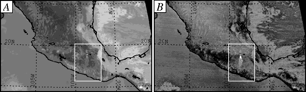
The band subtraction technique is demonstrated in Figure 1, an image from a small ash emission event of Popocatepetl Volcano, collected at 1945 UT (local time=UT-6) on March 10, 1996. Figure 1a is a band 4 image, and Figure 1b is the corresponding band 4-5 image. In the band 4 image (Fig. 1A) bright features, such as high clouds, are cold (~-20 C.), and dark features, such as land, are warm (~25-30 C). Note that although a small bright feature exists near the volcano, it looks very similar to other features in the image. By comparison, in the band 4-5 image (Fig. 1B), bright features have a negative brightness temperature difference (maximum value: -4 C), while dark features have positive differences (maximum value: 2 C). In this image, the detected volcanic cloud is indicated by its characteristic negative temperature difference (bright feature), and clearly discriminated from meteorological clouds (dark features).
The mass of fine-grained (1-10 micron radius) volcanic ash was retrieved from the GOES image data, following the technique developed by Wen and Rose (1994) for use with AVHRR. The retrievals assume a single layer, partially transparent cloud, which is parallel to a homogeneous underlying surface, and composed entirely of spherical andesitic particles having a lognormal size distribution. The retrieval model was modified to account for the slight difference in position of the GOES band 4 (10.2 to 11.2 microns) versus AVHRR band 4 (10.3 to 11.3 microns). The volcanic cloud height was estimated at 400 mb (6.5 km), by comparing the cloud trajectory to radiosonde wind data from Mexico City, which yields a corresponding radiosonde temperature of -23 C.
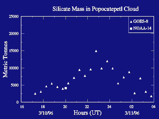
The results of the mass retrievals are shown in Figure 2, and demonstrate that GOES image data can be used to detect and measure the volcanic ash from small explosive eruptions. The retrieved mass ranges from 2-15 kT of volcanic ash, which compares very well with a mass retrieval conducted on an AVHRR (4km spatial resolution) image collected at 2000 UT on March 10. Based on cloud height, the event described in this paper had a Volcanic Explosivity Index (VEI) (Self and Newhall, 1982) of 1 or possibly 2. The temporal resolution of the GOES imager, should allow for more observations of the highly ephemeral ash clouds from small to moderate explosive eruptions (VEI 1-2), which occur much more frequently than moderate to large eruptions (VEI 3-4) (Simpkin and Siebert, 1994).
Maps of the retrieved volcanic ash mass are shown in Figure 3, and document the extent of the ash plume, and the eruptive state of the volcano, from 1715 UT on March 10 to 0215 UT on March 11 at one hour intervals. In the first image analyzed (Fig. 3A), the detected volcanic cloud extended approximately 140 km south of the vent, was about 15 km wide, and covered 1300 km2. By 1915 UT (Fig. 3C), the cloud started to fan out and form a v-shaped plume, with its vertex at the vent. The detected cloud had a maximum width of 45 km, at a point 75 km south of the vent, and covered 2450 km2. The area of cloud continued to increase, and by 2115 UT (Fig. 3E) the cloud covered 5350 km2, and was 75 km wide at a point 100 km south of the vent. By 2245 UT, the v-shape of the cloud starts to diminish, and the cloud starts a transition to an elongated plume. By 0015 UT on March 11 (Fig. 3H), the plume appears to detach from the vent, and drift to the south. Ash in the drifting cloud is visible in the imagery for about 3 hours, until 0245 UT. At 0115 UT (Fig. 3I), a new, much smaller plume is visible, extending 25 km from the vent. This plume was the result of an ash emission event which started at 0045 UT, and was accompanied by a small 2-minute duration volcanic earthquake (Smithsonian Institution, 1996). By 0215, the plume extends about 75 km to the south, and covers 2125 km2. The small plume detaches from vent at 0315 UT and is seen drifting to the south until the end of studied imagery at 0345 UT on March 11, 1996.

The frequent measurements of ash masses in volcanic clouds, available with the GOES imager, allows for a new type of monitoring of activity. The fall rate for simple particles with an effective radii of 5 microns (as determined from the mass retrieval model) and an initial height of 7 km, is 300-400 m/hr. Thus, the ash would be expected to be removed in about 10 hours with no replenishment. The rate of mass increase measured from 1700 UT until 2300 UT on March 10 show that the volcano was erupting continually at a rate which is faster than the rate of fallout, which resulted in the increase in the total retrieved mass shown in Figure 2. The decreasing mass observed after 2315 UT show that eruption rate declined, and this was followed by the observation of detachment at 2345 UT. The half life of the mass of the drifting cloud is about 2 hrs, suggesting that the ash may be falling out faster that could be explained by the fall of simple particles, perhaps reflecting agglomeration.
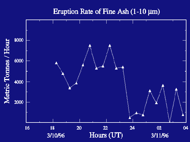
An estimate the eruption rate of fine ash (1-10 micron radius) was made and is shown in Figure 4. The estimate was made by subtracting the cloud mass at t0 from the subsequent cloud mass, t1, and adding a constant fallout rate [(mass t1 - mass t0) + fallout rate)]. A three- point moving average was applied to individual mass retrieval values to reduce the noise level, and the fallout rate was determined from the mass retrievals of the detached cloud (from 0015 UT to 0215 UT on March 11.) Two main pulses of activity are indicated in figure 4; one which ends at 1915 UT, and the other from 1915 UT to 2315 UT. A minor pulse from 0045 to 0315 UT on March 11 is also observed. Because the eruption rate estimate is based on the satellite retrievals of airborne ash, which is typically several percent of the total mass of an eruption, the actual rate may be up to 100 times greater.
A primary factor in the successful discrimination of the volcanic cloud from this small explosive event was the high thermal contrast (as great as 50 C) between the volcanic cloud and the underlying surface. Due to the height of the volcano (5465 m), small ash clouds that rise several kilometers above the vent, cool to the ambient atmospheric temperature of -20 to -30 C. This combined with warm ground temperatures (20 to 25 C), produce adequate thermal contrast. It is important to note that the discrimination was done under clear meteorological conditions, and it is doubtful that the volcanic cloud would have been detected if it was overlying cold, meteorological clouds, because the thermal contrast would be much lower.
The mass of airborne ash, and the areal extent of the detected volcanic cloud, increased after the end of continuous tremor, at 2110 UT on March 10. AVHRR data from the period of continuous tremor was analyzed to determine if the GOES analysis post-dated a larger ash emission event. The area of the volcanic cloud detected by the AVHRR at March 10 at 0845 UT, was only 1000 km2. Thus, it seems that the GOES imagery did record an actual increase in the ash emission, after the end of continuous tremor. It is unknown why the eruption rate of volcanic ash increased after the volcanic tremor stopped, but these observations reinforce the usefulness of the satellite imagery in determining the eruptive state of the volcano.
The thermal band difference technique was successful in discriminating the very small volcanic clouds from Popocatepetl volcano, under favorable atmospheric conditions. The frequency of available imagery provides much greater detail on eruptive events than could be observed using AVHRR. Twenty-two GOES images were analyzed for this study, for a time period that was covered by just two AVHRR images. For this study the GOES imager data was analyzed at 30 minute intervals, but imagery was available for analysis at 15 minute intervals. The high temporal resolution enables observation of many details of the eruption, especially time trends. Mass retrievals document an increase in ash emission over a six hour period, and the fallout of ash that followed. Analysis of the imagery was able to determine when the volcanic cloud detached from the vent and drifted away, and was able to detect the onset of a new, small, eruptive pulse.
The high temporal resolution of the GOES imager data make it possible to provide frequent observations of the status of volcanic activity, which is vital to the reduction of aviation hazard, and to estimate the eruption rate of fine volcanic ash. In addition, cloud mass retrievals can be used to verify cloud trajectory and fallout models, which are used to forecast the movement of volcanic ash [Heffter and Stunder, 1993; D'Amours, 1994] for aviation purposes. It might be possible to improve the forecasts by providing frequent updates to the models.
We would like to thank Mellisa Seymour of the Earth Scan Laboratory, Coastal Studies Institute at Louisiana State University for providing the GOES data. Funding was provided by the NASA Earth System Science Fellowship Program.