Klyuchevskoi: Radiannet Example
The 1994 eruption of Klyuchevskoi Volcano in Kamchatka, Russia produced
a volcanic cloud that was potentially hazardous to aircraft. The cloud
from this eruption moved easterly for thousands of kilometers and
crossed the polar air routes. To view a complete set of AVHRR images
of the Klyuchevskoi volcanic cloud,
click here. Additonal
information on the eruption can be found on the
Michigan Tech Volcanoes Page.
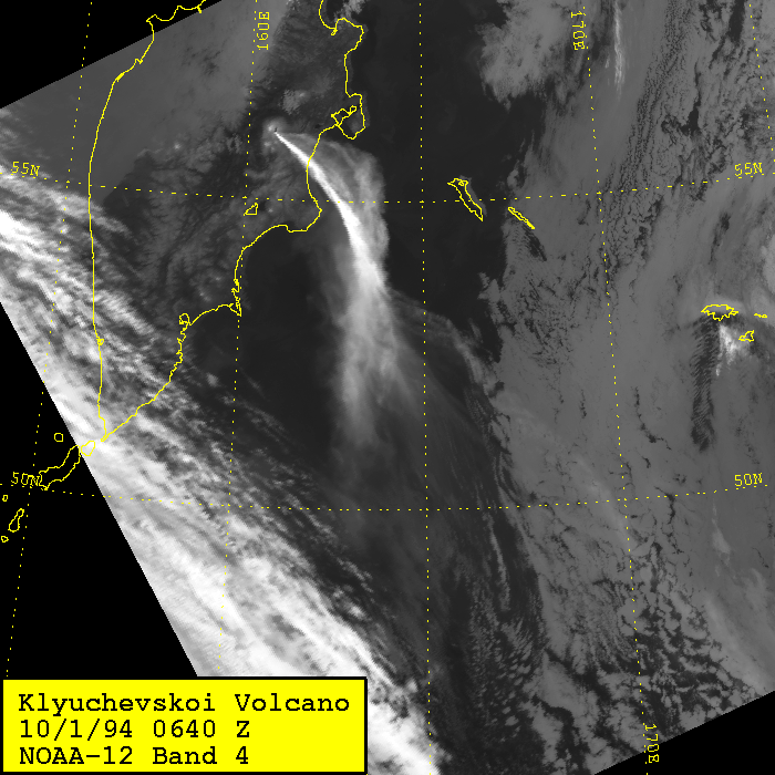
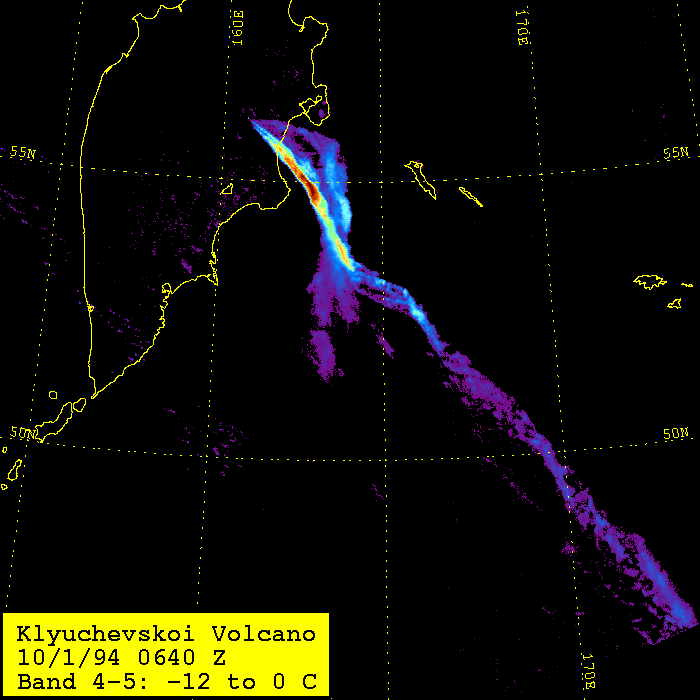
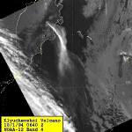
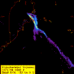
October 1, 1994 at 0640 Z
The band 4 image shows the volcanic cloud moving towards the south over
the Pacific Ocean. Note that the presence of a wind shear near the
volcano. In the band 4-5 image, the cloud is easily discriminated from
the meteorlogical clouds, and an addtion region of the cloud is clearly
defined where it is underlain by low clouds (in the southwest quadrant).
AVHRR Band 4 image (left) and Band 4-5 image (right).
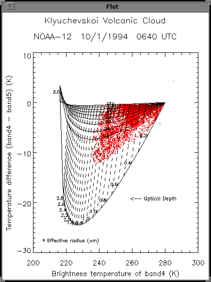
Radiannet Plots
These plots are generated by Radiannet, using the input parameters
specified by the user, and are used to evaluate if the appropriate
parameters were choosen. Click here
for a discription of the plots generated by Radiannet.
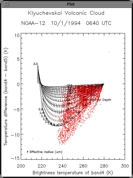
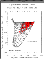
The plot on the left is the Radius-Optical depth plot for the image
shown above. The red dots are the actual AVHRR pixel values for the cloud, the
solid lines are theoretical effective radius values and the dashed lines are
theoretical optical depth values. Note that the cloud has a wide range of
optical depths, and that the AVHRR values fit well inside the Radius-Optical
Depth envelope constructed using the input conditions. (See below for input
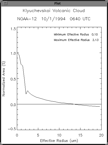
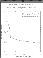
values). The plot in the middle is the range of effective radius values
that can be retrieved using the input values for effective radius of .1 to 20
microns. Note that there are two ranges
of values that can be retrieved uniquely: from 0.10 to 2.13 and from about
2.5 to 15 microns. In a case like this a decision needs to be made.
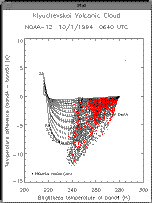
The plot on the right shows that if the range from 2.5 to 15 microns
is choosen, most of the AVHRR values fit inside of the envelope. Those
that are outside the envelope are mapped to a value of 2.5.
Input parameters and output values
Execution Date  . . . . . .               Thu May  4 11:50:45 EDT 1995
ASCII Input Data File Name                                  ascii.0640
Plot Title  . . . . . . . .                Klyuchevskoi Volcanic Cloud
Plot Subtitle . . . . . . .               NOAA-12  10/1/1994  0640 UTC
Theoretical Particle Size Distribution  . . . .              Lognormal
The Scale of the Mass Retrieval . . . . . . . .  Frame Scale Retrieval
Aerosol Type  . . . . . . . . . . . . . . . . .               Andesite

Minimum Effective Radius (um)  . . . . . . . . . . . . . .        2.50
Maximum Effective Radius (um)  . . . . . . . . . . . . . .       15.00
Cloud-Top Temperature (K)  . . . . . . . . . . . . . . . .      216.00
Cloud-Base Temperature (K) . . . . . . . . . . . . . . . .      280.00
X Image Dimension  . . . . . . . . . . . . . . . . . . . .    14721.00
Y Image Dimension  . . . . . . . . . . . . . . . . . . . .        1.00
Pixel Area (km^2)  . . . . . . . . . . . . . . . . . . . .        4.00
Delta X  . . . . . . . . . . . . . . . . . . . . . . . . .        0.05
Band 4 Minus Band 5 Maximum Cutoff Value . . . . . . . . .        0.00
Number of Horizontal Lines . . . . . . . . . . . . . . . .       30.00
Number of Radii Lines  . . . . . . . . . . . . . . . . . .       20.00

Total Number of Volcanic Pixels  . . . . . . . . . . . . .    14721.00
Mean Effective Radius (um) . . . . . . . . . . . . . . . .        7.07
Mean Optical Depth of the Volcanic Pixels  . . . . . . . .        0.47
Mean Volcanic Pixel Mass (Mt)  . . . . . . . . . . . . . .       16.74
Total Volcanic Cloud Mass (Mt) . . . . . . . . . . . . . .   246500.00
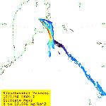
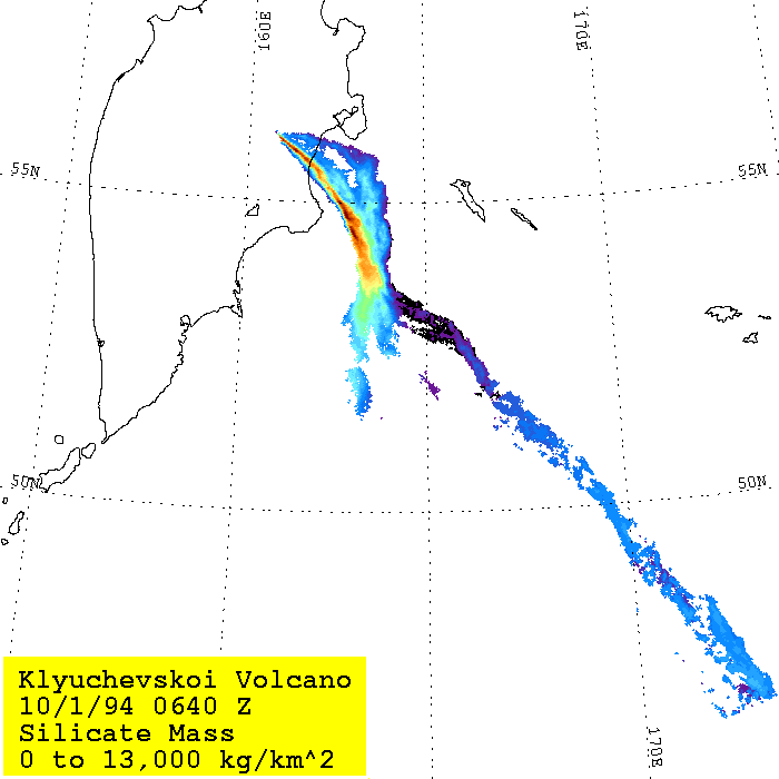
Map of Silicate Mass Retrieval
The following image is a map of the mass retrieval using the parameters
shown above. Note that in this case, the regions of high mass correspond
closely with the regions of large band 4-5 temperature difference.