 (639x317 GIF - 151K)
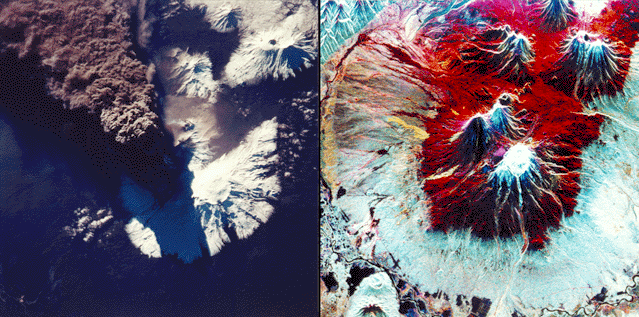
This comparison shows optical and radar imaging of Kliuchevskoi volcano in Kamchatka, Russia, which began to erupt on September 30, 1994, as space shuttle mission STS-68 was beginning with its Spaceborne Imaging Radar C/X-Band Synthetic Aperture Radar (SIR-C/X-SAR) payload.
The optical photo at left was taken by shuttle astronauts during the early hours of the eruption on September 30. The ash plume, which reached heights of more than 18 kilometers (50,000 feet), is emerging from a vent on the north flank of Kliuchevskoi, partially hidden by the plume and its shadow in this view. The photograph is oriented with north toward the bottom, for comparison with the radar image at right acquired a few days later. Near the center of the photo, a small whitish steam plume may be seen emanating from the growing lava dome of a companion volcano, Bezymianny.
In the radar image at right, Kliuchevskoi is the blue triangular peak in the center of the image, towards the left edge of the bright red area that delineates bare snow cover. The image was acquired by SIR-C/X-SAR aboard the space shuttle Endeavour on its 88th orbit on October 5, 1994. The image shows an area approximately 75 kilometers by 100 kilometers (46 miles by 62 miles) that is centered at 56.07 degrees north latitude and 160.84 degrees east longitude. North is toward the bottom of the image. The radar illumination is from the top of the image. The Kamchatka volcanoes are among the most active volcanoes in the world. The volcanic zone sits above a tectonic plate boundary, where the Pacific plate is sinking beneath the northeast edge of the Eurasian plate. The Endeavour crew obtained dramatic video and photographic images of this region during the eruption, which will assist scientists in analyzing the dynamics of the recent activity. The colors in this image were obtained using the following radar channels: red represents the L- band (horizontally transmitted and received); green represents the L-band (horizontally transmitted and vertically received); blue represents the C-band (horizontally transmitted and vertically received). In addition to Kliuchevskoi, two other active volcanoes are visible in the image. Bezymianny, the circular crater above and to the right of Kliuchevskoi, contains a slowly growing lava dome. Tolbachik is the large volcano with a dark summit crater near the upper right edge of the red snow covered area. The Kamchatka River runs from right to left across the bottom of the image. The current eruption of Kliuchevskoi included massive ejections of gas, vapor and ash, which reached altitudes of 15,000 meters (50,000 feet). Melting snow mixed with volcanic ash triggered mudflows on the flanks of the volcano. Paths of these flows can be seen as thin lines in various shades of blue and green on the north flank in the center of the image.
For a full-resolution copy of the radar image (P-44823) (1202x835 JPG - 418K)
For a full-resolution copy of the optical image (P-44828) (2254x2248 JPG - 6946K) (Big, but very cool!)
Spaceborne Imaging Radar-C and X-band Synthetic Aperture Radar (SIR-C/X-SAR) is part of NASA's Mission to Planet Earth. The radars illuminate Earth with microwaves, allowing detailed observations at any time, regardless of weather or sunlight conditions. SIR-C/X-SAR uses three microwave wavelengths: L- band (24 cm), C-band (6 cm) and X-band (3 cm). The multi- frequency data will be used by the international scientific community to better understand the global environment and how it is changing. The SIR-C/X-SAR data, complemented by aircraft and ground studies, will give scientists clearer insights into those environmental changes which are caused by nature and those changes which are induced by human activity. SIR-C w as developed by NASA's Jet Propulsion Laboratory. X-SAR was developed by the Dornier and Alenia Spazio companies for the German space agency, Deutsche Agentur fuer Raumfahrtangelegenheiten (DARA), and the Italian space agency, Agenzia Spaziale Italiana (ASI), with the Deutsche Forschungsanstalt fuer Luft und Raumfahrt e.v.(DLR), the major partner in science, operations and data processing of X-SAR.