
San Salvador volcano is a composite stratovolcano which at its base has a diameter of approximately 15 km. The elevation of the Boquerón crater is 1893 m and has a diameter close to 1.5 km and a depth of about 500 m. In the interior of the crater lies a small cinder cone that was formed during the last eruption in 1917. Prior to the eruption a small crater lake existed.
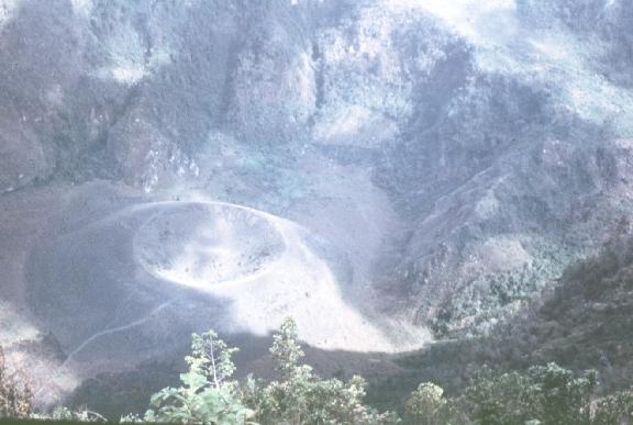
Photo of the scoria cone inside Boqueron crater formed during the 1917 eruption, by Fairbrothers, 1979
West of the main crater along a line parallel to the Central American graben (WNW-ESE), four explosion craters are found. The most westerly of these is a maar locally called "Laguna de Chanmico". It has a diameter of approximately 1 km and is at 466 m.a.s.l. The remaining three explosion craters lie on the flanks of the volcano at elevations of 580, 820 and 1100 m.
Along the NNW-SSE trend several explosion craters, cinder cones and eruptive fissures are found. At the SSE end of this trend, an explosion crater locally called "Plan de la Laguna" lies among one of the capital city's suburbs. Several factories and botanical gardens are built inside the crater, while on its rim the United States Embassy was recently built. At an elevation of 1172 m on the southern flank of the volcano, a small cinder cone has active low temperature fumaroles. On the northwestern side of San Salvador volcano, several eruptive fissures have been the center of historical eruptions, having produced extensive lava fields, cinder cones and explosion craters.