Source:
http://worldatlas.com/webimage/countrys/namerica/camerica/gt.htm
General
Information
History Infrastructure Media Outlets Government
Agencies Universities Embassies and Consulates
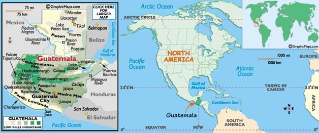
Maps and geographic Information Government
To know more about
http://en.wikipedia.org/wiki/Guatemala
http://
www.deguate.com
https://www.cia.gov/cia/publications/factbook/geos/gt.html
History:
The
Mayans were dominant through much of
The
government of Colonel Arbenz Guzman attempted various
land reforms in the early 1950s, but was overthrown by a US-backed invasion led
by military opponents of Arbenz. The country then
slid into a state of almost perpetual civil war between a series of right-wing
military governments and various leftist guerrilla movements: a major figure
during this period was the former general Efrain Rios Montt,
a self-styled evangelist who as army chief of staff and (briefly) president
during the 1970s and 80s presided over a vicious counter-insurgency campaign
whose savagery was exceptional even by the standards of the era and the region.
Although
The
most recent polls in December 2003 brought victory for the FRG for a second
consecutive term. The FRG and PAN now dominate Guatemalan politics. Only now
has the Government been prepared to admit that its predecessors, especially the
Rios Montt regime, were responsible for massive human
rights abuses: this is still a central and highly sensitive issue in Guatemalan
domestic politics. An exhaustive UN-sponsored investigation concluded in 1999
that the army was responsible for 90 per cent of the estimated 200,000
killings. The complicity and active assistance of successive American
governments in the counter-insurgency campaign was also highlighted, and drew
an unprecedented apology from
From
(http://www.iexplore.com/dmap/Guatemala/History)
Infrastructure
Railways
total:
* 322 km (200 miles) operated by RDC,
freight only
* 563 km (350 miles) closed
narrow gauge: 884 km 0.914-m gauge (single
track)
Railway links with adjacent countries
*
*
*
*
Highways
total:
13,100 km
paved:
3,616 km (including 140 km of expressways)
unpaved: 9,484 km (1996 est.)
Waterways
260
km navigable year round; additional 730 km navigable during high-water season
Ports and harbors
Atlantic Ocean
* Puerto
Barrios, Santo Tomás de Castilla
Pacific Ocean
* Champerico, Puerto Quetzal, Puerto San José
Airports
477
(1999 est.)
Airports - with paved runways
Total:
11
2,438
to 3,047 m: 3
1,524
to 2,437 m: 2
914
to 1,523 m: 5
under
914 m: 2 (1999 est.)
Embassies and
Consulates:
Link
to the list of Embassies in
http://www.minex.gob.gt/SistemaProtocolo/ProtocoloS/ConsultaM.asp?T=MRE0SPQ&A=DGI3S
Universities
(Information in
Spanish)
Universidad
Galileo
Universidad
de San Carlos de Guatemala
Universidad del Istmo
Universidad
del Valle de Guatemala
Universidad
Francisco Marroquín
Universidad Mesoamericana
Universidad Panamericana
Government Agencies
Related to
natural resources
(most
of the information is in Spanish)
Ministries
Ministerio de Energía y Minas: http://www.mem.gob.gt
Ministerio de Ambiente y Recursos Naturales http://www.marn.gob.gt
Institutions
INSIVUMEH. Instituto Nacional de Sismología, Vulcanología,
Meteorología e Hidrología. http://www.insivumeh.gob.gt/
IGN: Instituto Geográfico Nacional: http://www.ign.gob.gt/
CONRED: Coordinadora Nacional Para la Reducción de
Desastres www.conred.org/principal.php
CONAP:
Consejo Nacional de Areas Protegidas
http://conap.online.fr/
Geographic
Information
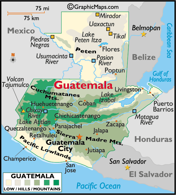
Links to other sources of maps:
http://209.15.138.224/inmochapin/maps.htm
Media Outlets
PRESS (In Spanish)
|
PRENSA LIBRE |
|
|
LA HORA |
|
|
SIGLO VEINTIUNO |
|
|
EL PERIODICO |
|
|
DIARIO DE CENTRO |
|
|
LA REPUBLICA |
------- |
|
NUESTRO DIARIO |
|
|
AL DIA |
------- |
|
EL QUETZALTECO |
------- |
|
EL METROPOLITANO |
Government
Under
the 1986 constitution, legislative power is vested in a single-chamber elected assembly
with 80 members directly elected every four years. The President, also elected
every four years, holds executive power.