 (Minnesota Geological Circular XXX)


T. Bornhorst (Michigan Tech), L. Woodruff (USGS), and S. Nicholson (USGS)
(Minnesota Geological Circular XXX)
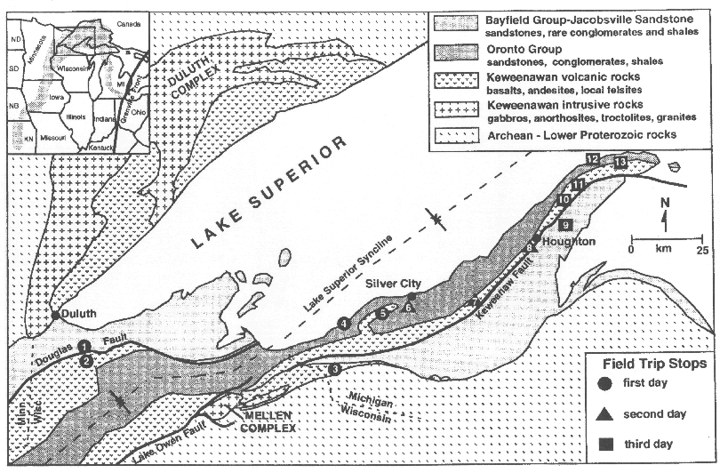
The Midcontinent Rift system of North America extends for more than 2000 km northeasterly from Kansas through the Lake Superior region and then southeasterly through lower Michigan. The rift has been postulated to be the result of a mantle plume, based on the enormous volume of dominantly tholeiitic composition igneous rocks and the short subaerial eruption interval (Paces and Bell, 1989; Hutchinson et al., 1990; Nicholson and Shirey, 1990). A traverse from west to east through northern Wisconsin and upper Michigan provides a complete temporal and stratigraphic cross-section of the rift. Early and late rift-filling volcanic rocks,sedimentary rocks in both the central rift graben and flanking basins, and the major reverse faults (originally graben-bounding normal faults) bounding the central graben can all be seen.
Also visible are rift rocks in Michigan which host the active world-class copper deposit in black shale at White Pine, the dormant famous Keweenawan native copper district, and a zone of chalcocite mineralization in basalt for which production is planned in 1995.
This summary of the stratigraphy, structure, and mineralization of rift rocks provides an overview of rift rocks in northern Wisconsin and upper Michigan.