Connection to the Earth Science Curriculum
Essential Lessons:
1. How does energy from wind and water shape a landscape?
Big Idea 4.6 – Earth’s materials take many different forms as they cycle through the geosphere.
Big Idea 4.8 – Weathered and unstable rock materials erode from some parts of Earth’s surface and are deposited in others.
1. Earth/rocks do not change.
2. The Earth has always been pretty much the way it is now.
3. All rocks are the same.
Michigan State Science Content Expectations Addressed:
E.SE.06.12 Explain how waves, wind, water, and glacier movement shape the land
surface of the Earth by eroding rock in some areas and depositing sediments in
other areas.
E.SE.06.41 Compare and contrast the formation of rock types (igneous, metamorphic,
and sedimentary) and demonstrate similarities and differences using the rock
cycle model.
P.EN.07.33 Demonstrate how waves transfer energy when they interact with matter (for
example: a tuning fork in water, waves hitting a beach, earthquake knocking
over buildings).
E3p1B Explain how physical and chemical weathering leads to erosion and the
formation of soils and sediments.
E3p1C Describe how coastal features are formed by wave erosion and deposition.
E3.1A Discriminate between igneous, metamorphic, and sedimentary rocks and
describe the processes that change one rock into another.
E3.1B Explain the relationship between the rock cycle and plate tectonics
theory in regard to the origins of igneous, sedimentary, and metamorphic
rocks.
Basalt – a volcanic rock, dark in color; forms when lava flows onto the surface of the Earth and cools quickly creating a fine grain
Conglomerate – a sedimentary rock; made up of a variety of pebbles cemented together by fine particles
Rhyolite – a volcanic rock, lighter in color than basalt; forms when lava flows onto the surface of the Earth and cools quickly creating a fine grain
Date Visited
Horseshoe
Harbor Beach
Horseshoe
Harbor is located on the northern shore at the tip of the Keweenaw
Peninsula. This pristine beach is a
prime location for understanding the Earth’s past, and how the Earth constantly
changes to create its present.
Difficulty: 4.5 (This site
is only accessible by a trail head located on a two-track dirt road.)
Terrain: 4.0 (Mildly hilly hike, approximately .5 mi,
terrain includes rocks and roots on dirt path.)
Directions:
1. Before you leave check, the batteries in your
GPS.
2. Be sure you know how
to use your GPS to enter and label waypoint coordinates and navigate to waypoints.
3.
Answer the logging questions below.
Coordinates:
Background and History Information
Upon arrival at the beach, your first glimpse is the beauty of Lake Superior. On either side of the beach, you’ll also notice large Copper Harbor Conglomerate rock formations jutting into the water, providing some protection from the amazing power of the wind and waves that can be created on this large lake. The protection is limited though, and you’ll notice as you walk along the beach that Horseshoe Harbor does not have the beautiful white sand found on much of the Michigan shorelines; this shoreline is different.
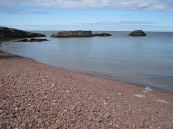
Figure 1 A view from the trail at Horseshoe Harbor, with
the Copper Harbor conglomerate structures jutting into the water. The sheer size of Lake Superior dominates the
background. Photo by A. Ernstes
The
origin of the rock formation here happened approximately 1 billion years ago
when a rift valley was formed in the center of the North American
continent. This caused many sequences of
lava flows, which is why we now find volcanic basalts and rhyolites
here. However, eruptions were not
consistent over time, and this allowed for periods of erosion to occur between
lava flows. Repetition of these
sequences combined with tremendous pressure from the layers piling atop one
another formed the conglomerate structures now visible at Horseshoe Harbor.
These
formations were revealed through series of faults and fractures in the northern
Michigan region. A continental collision
caused the Copper Harbor Conglomerates to be squeezed upward, causing them to
become exposed both along the northern shore of the Keweenaw, and at Isle
Royale.
Tour of Horseshoe Harbor
To
reach Horseshoe Harbor, begin in Copper Harbor and travel east on Highway 41. Continue east until you reach 47°27.757’ N,
087°49.359’ W. At this point you will be
turning north onto a two-track dirt road.
Continue along this two-track road until you reach the trailhead located
at 47°28.153’ N, 087°48.224’ W. At this
point, park your vehicle and proceed along the trail until you reach 47°28.340’
N, 087°48.077’ W. (Insect repellent is
recommended for this hike.)
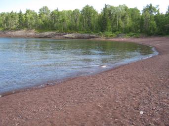
Figure 2 Horseshoe Harbor is located on the northern
shore of the Keweenaw Peninsula. Note
the reddish brown color of the rhyolite pebbles on the beach. Photo by A. Ernstes
When
you reach the beach, make an observation of the shoreline. You’ll notice that it is unlike the white sand
beaches so typically found on Michigan shorelines.
Logging Q1: Describe the pebbles/cobbles found here. (Size, shape, colors, makeup etc.)
Compare/contrast those found near the shoreline to those found near the tree
line.
Logging Q2: What natural process(es)
could have caused the pebbles and cobbles to be deposited here and arranged in
such a way?
Now,
notice the large conglomerate structures found on either side of the
beach. These are the structures formed
many years ago through sequences of volcanic activity separated by weathering
and erosion. Initially, about a billion
years ago, lava poured onto the Earth’s surface from openings created by a Mid-continent
rift. The lava filled the valley created
by the rift, and cooled rather quickly forming the basalt and rhyolite found
here. During a time of little or no
volcanic activity, weathering and erosion from the edge of the volcanic rift
along with ancient mountains led to deposition of sediments in the rift
valley. These two processes alternated
over time. The immense weight caused the
entire area to sink, and become cemented together. Finally, a collision of continental plates
caused the entire rock formation to be tilted and revealed the structures that
you see here today at Horseshoe Harbor. They are formed mainly of igneous rock, with a
high percentage of densely formed basalt and rhyolite. Cementing the conglomerate structure is a
small percentage of sedimentary rock such as shale and sandstone which are generally
not as strong and durable as igneous formations.
Logging Q3: Take a closer look at one of the conglomerate
formations on either side of the beach. What
is the connection between these conglomerate structures to the pebbles that now
exist on the shoreline?
Bonus Logging Question: Make note of any exceptions to the
pebbles/cobbles generally found on the beach.
Make a claim and include evidence about how these rocks came to rest on
this beach.
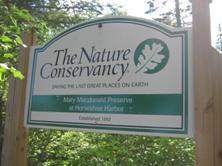
Figure 3 The Michigan chapter of the Nature Conservancy
is dedicated to preserving this location.
Photo by A. Ernstes
Access Information
This
land is owned by the Michigan Chapter of the Nature Conservancy. It is only open during summer months as the
dirt road and parking area are not maintained during the winter.
References and Citations
Robinson,
S. (2001). Is
this an agate?:
An illustrated guide to Lake Superior’s beach stones Michigan. Hancock, Mich: Book Concerns Printers.
Schaetzl,
Randall J., Joe T. Darden, and Danita S. Brandt. Michigan Geography and Geology. New York:
Custom, 2009. Print.
United
States Geological Survey. Copper Harbor conglomerate on
Isle Royale. Retrieved
July 25, 2011 from http://www.nps.gov/history/history/online_books/geology/publications/pp/754-B/sec2.htm