Connection to the Earth Science Curriculum Essential Lessons: When in the
Quincy Mine you will see a dramatic high, scaffold “stope,” the enlarge rock
diggings where copper deposits have been found. Essential Questions: How are faults associated with
mining? What can you tell me about the stopes
in the mine? (Optional question)
#4 Earth is continuously changing #7 Humans depend on Earth of
resources Geologic and
social history cannot be found in rocks. Earth’s
resources are not finite-there is an endless supply of water, petroleum, and
mineral resources. All we have to do is
explore for them. E.SE.E1 Earth Materials- Earth materials that occur in
nature include rocks, minerals, soils, water, and the gases of the
atmosphere. Some Earth materials have
properties which sustain plant and animal life.
E.SE.E 2 Surface Changes- The surface of Earth changes, some changes are due to slow processes, such
as erosion and weathering, and some changes are due to rapid processes, such as
landslides, volcanic eruptions, and earthquakes. E.SE.E3 Using Earth Materials- Some Earth materials have
properties that make them useful either in their present form or designed and
modified to solve human problems. They
can enhance the quality of life as in
the case of materials used for building or fuels used for heating and
transportation. Drift- underground tunnel where trammers
and miners worked. Stope- underground area where copper rock
was removed. Fault- In geology a fault is a planar
fracture or discontinuity in a volume of rock, across which there has been
significant displacement. Fault line- the surface trace of a fault, the
line of intersection between the fault plane and Earth’s surface. Slip- The relative movement, including direction, of the land on either side of a fault
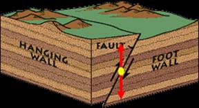
Figure 3. Diagram demonstrating the concepts of hanging
wall and foot wall associated with a fault. http://serc.carleton.edu/quantskills/methods/quantlit/stressandstrain.html Hanging wall- To geologist this means the block of
land that sits above the fault; Miners define this as the rock above a mineral
deposit in a mine (or where their lanterns would hang). Foot wall- To geologist this means the block of land that sits below the fault; Miners define this as the rock underneath a mineral deposit in a mine (or where their feet would be). Date Visited: | Quincy Mine/ Hancock Fault
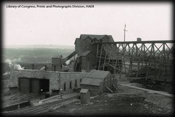
Figure 1.Quincy Mine
Library of Congress, Prints and Photographs Division, HAER Short Description: One of the
most celebrated and successful mine along the Keweenaw atop Quincy Hill. This mine produced 1.5 billion pounds of
copper and paid out 30 million dollars in dividends for almost a century. This mine
was established in 1846 and did not pay a single dividend until almost 20 years
later. Around 1857 the mine began to
show progress and the rest is history. In this
EarthCache visitors will explore the Hancock fault and its effects on the
copper miners at the Quincy Mine. This
feature will be explored above ground at various points along the fault line
or, for an optional closer look, at a below ground exposure during the Quincy
Mine Tour. Difficulty:
3.5 Terrain: 2.5 Coordinates: N 47 o 08.013’ W 88 o
34.748, Optional below ground view of the
Hancock fault from inside the Quincy Mine: 47o08.13’ N
88 o 34.28’ W
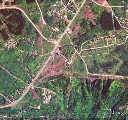 Figure 2. Google Earth Image of the Quincy Mine Area with
the Hancock Fault crossing in red.
Google Earth Content Explanation and Images: A fault is a
fracture or zone of fractures between two blocks of rock. Faults allow the blocks to move relative to
each other. This can happen fast, such
as in an earthquake or it could happen slowly in the form of creep. During an earthquake, the rock on one side of
the fault suddenly slips with respect to the other side. The surface of the faults can be horizontal
or vertical or somewhere in between. Faults were
very important to miners in the 1900’s.
These mines usually follow one mineral rich layer and faults disrupt the
regular order of layers. When miners encountered a fault, they would
have to find the mineral rich layer on the other side of the fault before they
could mine more. A miner needs to know
whether it’s a normal or reverse fault, or they won’t be able to find the
mineral rich layer. Earth
scientist uses the angle of the fault with the dip and the direction of slip
along the fault to classify it.
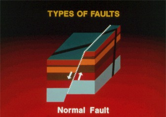
Figure A normal
fault is a dip-slip fault in which the block above the fault has moved downward
relative to the block below. This type
of fault is usually found in the Western United States Basin and Range Province
and along oceanic ridge systems. 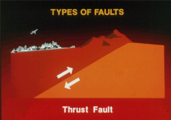 Figure 5. Source: Wikipedia.org/wiki/fault/geology A thrust fault (figure 5) is a dip-slope fault in which the upper block, above the fault plane, moves up and over the lower block. This type of faulting is found in the areas of compression, such as regions where one plate is being subducted under another. 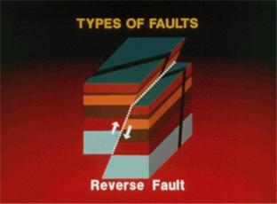 Figure 6.
Source: Wikipedia.org/wiki/fault/geology When the dip angle is shallow,
a reverse fault (figure 6) is often
described as a thrust fault.
Figure 7. Source: Wikipedia.org/wiki/fault/geology
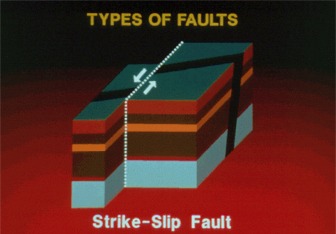
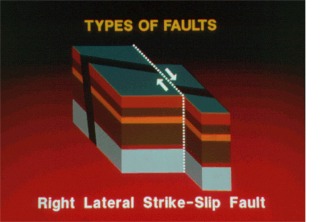
Figure 8. Source: Wikipedia.org/wiki/fault/geology In a strike- slip fault occurs when two blocks slide past one
another (figure 7). The San Andreas Fault in
California is an example of a right lateral, strike-slip fault (figure 8). As is often the case, standing on the surface at Quincy Mine you never see the Hancock fault itself but can sometimes detect the offset of the rock layers. Underground, inside the mine, you can see the fault exposed and classify its type. The major fault of the region is the Keweenaw Fault. This is a thrust fault and it exposed the ~1.1 billion year old lava layers by raising them thousands of feet above which the much younger sandstone layer. Above ground tour of the Hancock
Fault: Stop #1: N 47 o 08.013’ W 88 o 34.748- Quincy
Mine Office Stop #2: N 47 o
08.083’ W 88 o 34.565-
Quincy Shaft No. 7 Broiler House
with Jacobsville Sandstone blocks to South and Shaft No. 4 Hoist House to North
Stop #3: N 47 o
08.158’ W 88 o 34.367- Hoist
House #2 and impressively large core sample Stop #4: N 47 o
08.303’ W 88 o 33.990- Local
neighborhood with houses built for the miners of Quincy. Logging Questions: Choose one
of the four places you visited along the fault and give a few short sentences
describing what you see. How was this location important to the operation of the mine? Notice that
there is NO indication that the fault is below our feet. Describe something that is in your view. Optional Logging Question: Take the
full Quincy Mine Tour to go nearly one-half mile straight into the side of the Quincy
Hill just as the Copper Miners of the past. For information tours visit http://quincymine.com/ . Along the way you will pass an
exposure of the Hancock fault at: 47o08.13’
N 88 o 34.28’ W By looking
at the fault line inside the mine what type of fault do you think it is and how
do you know? Access Information: Quincy Historic Copper Mine Museum Surface and Underground Tours Quincy Mine Hoist Association 49750 US Highway 41, Hancock Mi.
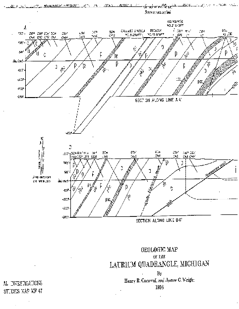
49930 906-482-3101 References and Citation: Cornwall, Henry R. & Wright, James C. (1956). Geologic Map of the
Laurium Quadrangle, Michigan. Ormand, Carol & Baer, Eric. (May
28, 2010). Teaching Quantitative Skills in the Geosciences, Stress and Strain.
Retrieved from http://serc.carleton.edu/quantskills/methods/quantlit/stressandstrain.html Quincy mine hoist association. (2011). Retrieved from http://www.
quincymine.com Ralph, J. (2011). Retrieved from http://www.mindat.org Usgs bc heritage. (2009). Retrieved from http://www.wells.entirety.ca/mining.htm Wikimedia foundation, inc. . (2011, July). Retrieved from http://www.wikipedia.org/wiki/fault/_geology.htm
Figure 9. Geologic
Map of Laurium Quadrangle, Michigan. Map
displays both the Hancock and Keweenaw Faults. Authors: Cornwall & Write |