|
The Menominee Crack |
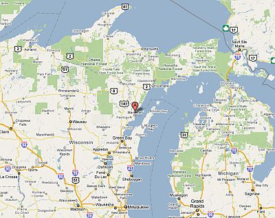
Figure 1

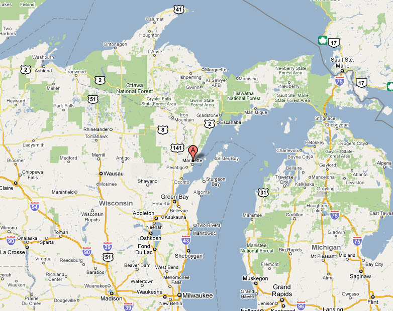
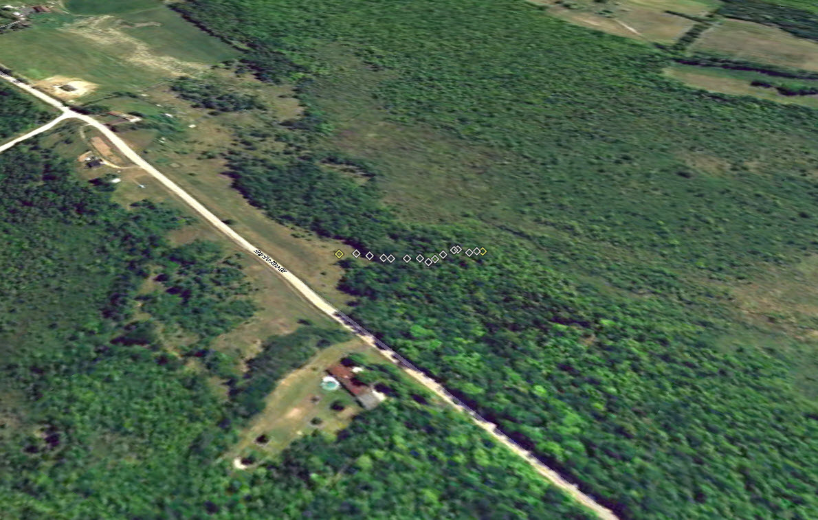
Figure 2: Click to enlarge (Image from Google Earth Pro)
|
On Monday morning, 04 October 2010, a large noise and shaking were observed in a small area north of the town of Menominee, in Michigan’s Upper Peninsula. The following day, a local resident returned to the site of a fallen tree that was being removed for firewood, and observed a large crack in the ground. This feature was reported to local officials, who contacted Michigan Tech, and the news media.
On Sunday, 09 October, Dr Wayne Pennington, Chair of the Department of Geological and Mining Engineering and Sciences of Michigan Technological University, visited the site (figure 1 and figure 2). The following is a report of observations and tentative conclusions.
|

Figure 3 Click to enlarge
|
Description of features:
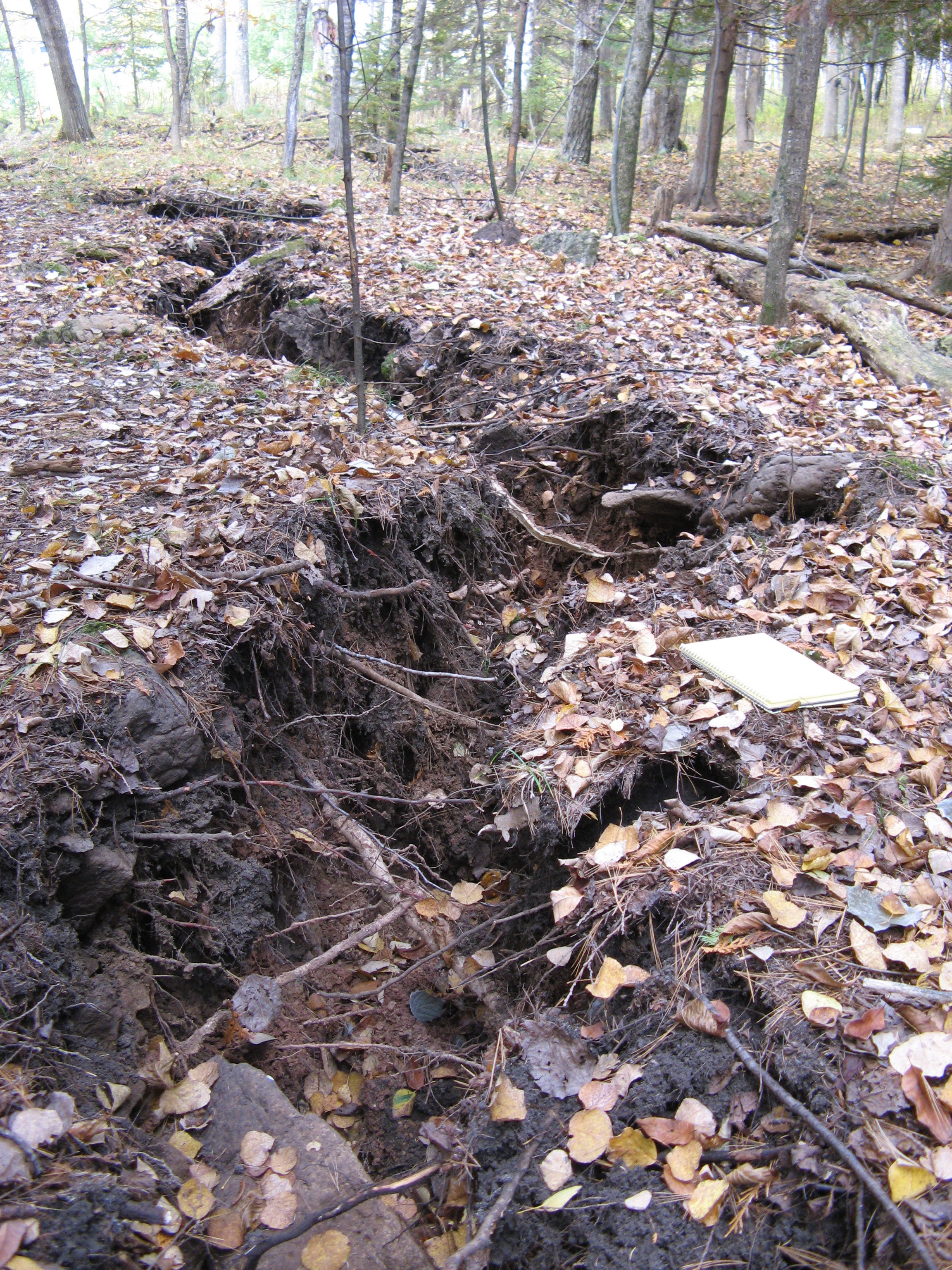
The crack (figure 3) is 361 ft in length (from GPS measurements), and about 2 ft wide and 5 ft deep at its maximum. The crack is in clay, overlain by a superficial layer of topsoil, a few inches at most. From nearby well records, we know that the clay is underlain by limestone at depths of about 10 to 20 ft, and some loose or erratic pieces of limestone can be observed at the surface. The crack has separated trees from their roots, and in some instances has split small tree trunks as some roots went one way and others went the opposite way (figure 4).
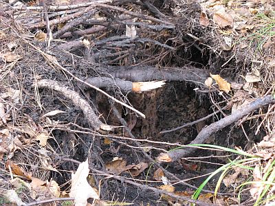
Figure 4
|
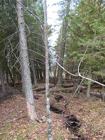
Figure 5
|
The trees are observed to tilt away from the crack dramatically (figure 5). The strongest tilting is exhibited by trees nearest the crack, at about 13.5°, and the trees further from the crack tilt at smaller angles.
The crack is at the crest of a small, long ridge, measuring over 360 ft in length, reaching just over 5 ft in height and 30 ft in width at its maximum, roughly in the middle of its length. The ridge appeared at the same time as crack, and the features are assumed to have the same cause. |
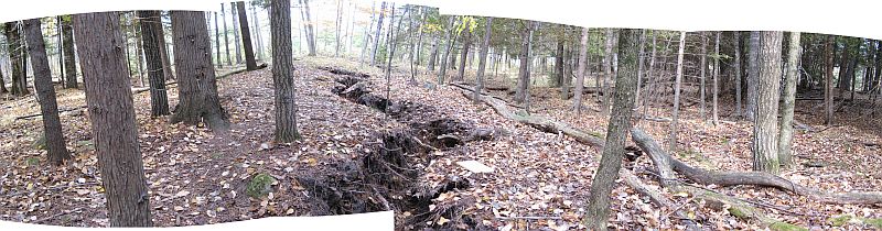
Figure 6 |
| Local residents were startled to observe the ridge where the land had been smooth and flat earlier; the trees tip in a way that is perpendicular to the surface of the ridge, confirming that the ridge is a new feature (figure 6). |
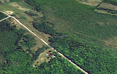
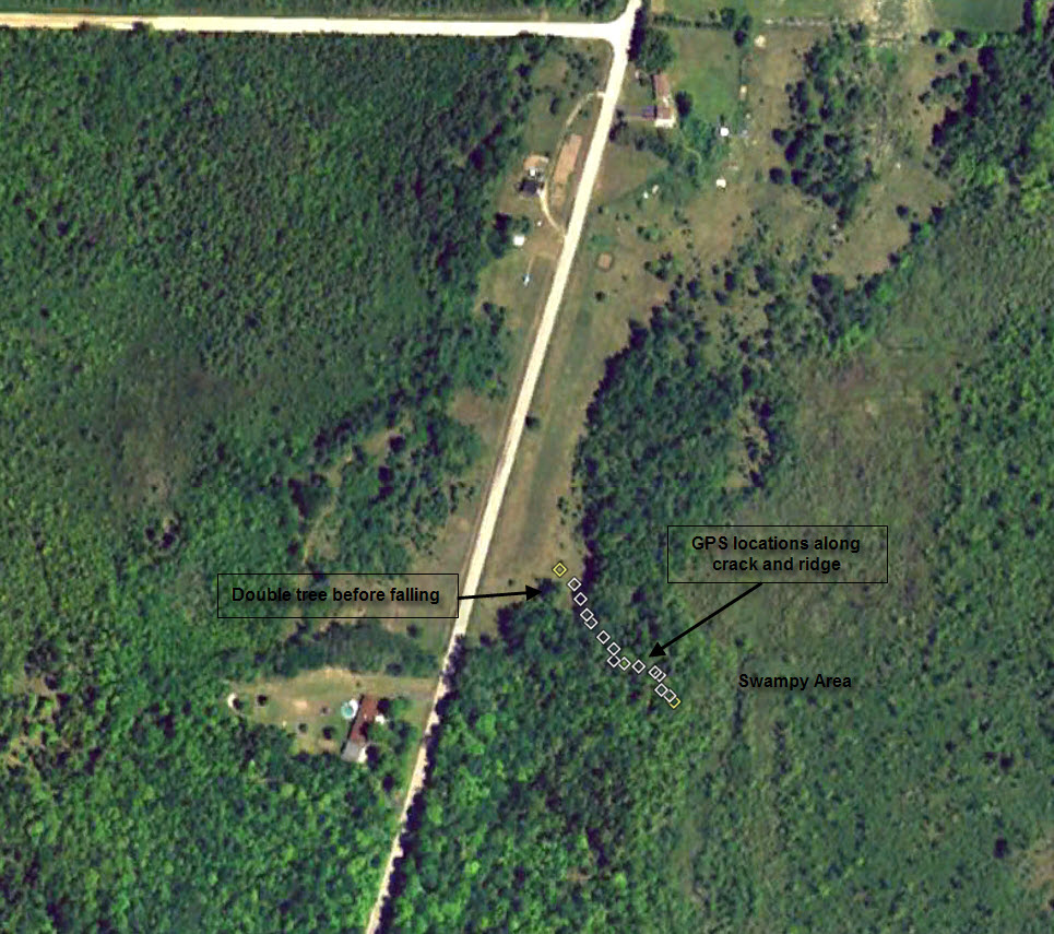
Figure 7 Click to enlarge (Image from Google Earth Pro) |
The crack and ridge extend in a direction 140° East of North (roughly SE-NW). The general slope of the surface in this area is slightly downhill in the SE direction, and the SE terminus of the ridge and crack are at the edge of a marshy area, while the NW terminus is in a clearing in a relatively low area (by about 20 ft) between higher land on which some homes are situated, and the county road. Most of the crack and ridge are in a wooded area that slopes gently to the marsh or swamp (figure 7).
|
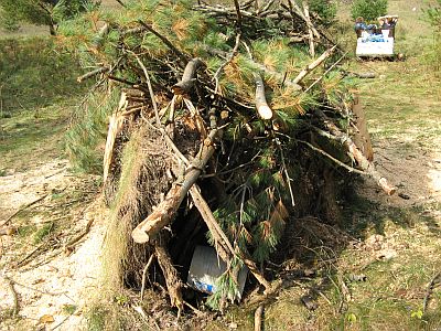
Figure 8 |
A double tree, with two trunks growing from one root ball, had fallen a couple of days after a strong windstorm about a week or ten days prior to the loud noise accompanying the formation of the crack and ridge. The tree was located about 25 feet from the crack near the uphill (NW) end. The two trunks fell in opposite directions, and had been salvaged in place for firewood (in fact, it was the person logging the fallen tree who first discovered the crack and ridge). The root balls, now exposed, seem too large to fit back in the hole from which they came (figure 8); it is unclear if this appearance is real and associated with the formation of the crack and ridge, or simply coincidental.
|
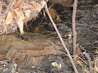
Figure 9
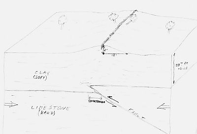
Figure 10
|
Tentative Explanation:
The crack itself is a remarkable and visible feature of the new landscape, but it is not the truly informative feature; that title is claimed by the ridge formed at the same time. The ridge (and tilting of the trees) indicates that the source of the disturbance is buried at a shallow depth – a 30-ft wide ridge is likely to have a source no deeper than about 30 ft. If the source of the deformation is extremely narrow, the depth could be about 30 ft; if the source is wider, then the depth is likely shallower. The clay layer is unlikely to be the source of the deformation itself. The crack exposes layers of clay for at least 5 feet depth, and the clay is undeformed for the entire depth that it can be observed (figure 9).
The deformation that caused the ridge and crack is certainly in the upper layers of the limestone that directly underlies the clay. At this location, the top of the limestone is apparently at 20 to 30 ft depth, based on records from nearby water wells.
One model, originally proposed, is that a small thrust fault in the limestone caused the uplift of the overlying clay layer (figure 10). This model, however, requires a shortening of several feet to result in the uplift seen, and is unreasonable because (1) such movement would result in a very large earthquake, and (2) the fault would be much longer than the 361 ft observed.
A very reasonable model, first proposed to us by Dr Norm Sleep of Stanford, is that the limestone underneath the clay experienced a “pop-up” due to lateral stresses. This model satisfactorily explains the features observed, but some questions remain as to the source of these lateral stresses and the timing of the event.
|
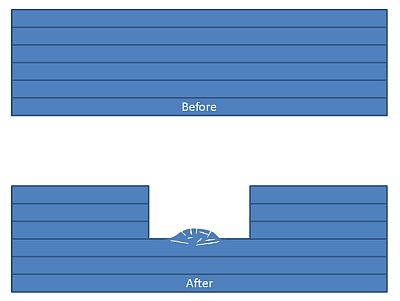
Figure 11 |
The Pop-Up Model
In the case of most pop-ups observed, the limestone has been lying under additional layers of limestone (or ice), and quarrying (or the retreat of a glacier) results in the sudden release of overburden weight holding the rock in place. The layer of limestone has been subjected, for a geologically long time, to the overburden, and this weight has been supported by stresses in the rock: because rock cannot deform by spreading out laterally, horizontal stresses exist in the rock as each piece pushes against its neighbor, supporting the load. When that load is removed, many of these lateral stresses may still exist, having been “locked in” the rock over geologic time; in some cases of quarries, the neighboring rocks still have the overburden weight on top of them, and the resulting lateral stresses can be large. Because the newly exposed layer no longer is confined from above, any small instability may initiate an upward buckling of the layer, which rapidly accelerates, resulting in a sudden noise and quite violent upheaval of rock (figure 11).
Pop-ups are known from many quarries worldwide, where the rock is exposed. They are also recognized in the geologic record, where they are buried under more-recent sediments, and can generally be explained by unloading due to the retreat of continental glaciers about 10,000 years ago. (Another usage of the term “pop-up” can refer to larger, tectonic-scale structures; this is not what is meant here.)
We are currently unaware of other examples of pop-ups that have been observed by humans that are not the result of quarrying operations; this may be the first known case of a contemporary pop-up that resulted from natural causes.
|
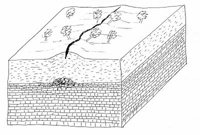
Figure 12 |
Despite this lack of other modern examples, we postulate that the Menonimee Crack is a result of a limestone pop-up immediately beneath the ridge. The limestone violently buckled upward, heaving the uppermost rock layers and the overlying clay layer, resulting in the ridge (figure 12). The crack is simply a superficial feature, resulting from the stretching of the surface clay as it bent upward, much as a crack forms in the top of a loaf of bread as the dough rises.
There are two remarkable aspects to this feature and the pop-up explanation: (1) there is no evidence for recent removal of the overburden that could have unloaded the limestone and triggering the buckling that initiates the pop-up; and (2) this is the first (to our knowledge) example of a modern, natural (not due to quarrying) pop-up that has been clearly documented by human observation. It is quite possible that other previously unexplained earthquake-like sounds and sensations have been due to similar events, but that the associated ridge (and crack) were never observed or reported.
Was it an Earthquake?
We have chosen to identify the sound and shaking that local residents experienced as evidence of an earthquake because the event fits the technical definition – a sudden movement of rock mass that resulted in the release of seismic energy through the earth. The event was too small to be recorded on seismographs, none of which are operating in the immediate area, but the observations of the residents clearly identify the seismic energy that was released, and formation of the ridge confirms that the sounds originated from rock movement. Therefore, this event can be labeled an earthquake, albeit a very small one, with magnitude of about 1 or 2. This classification means that it can be considered to be the first clearly documented earthquake in the Upper Peninsula that was not associated with an underground mine collapse (as are known from the Houghton/Hancock area in the early 1900’s, for example). This earthquake, however, has almost nothing in common with the usual concept of a natural tectonic earthquake, which would occur on a fault and result from large stresses rooted deeply within the earth’s crust.
What Does this Mean for the Future?
The limestone underneath the ridge has already had its stresses relieved, and is extremely unlikely to experience another, similar event. The areas beyond the current ridge and crack, to the SE and NW, may possibly be under stresses that are similar to those which caused the Menominee Crack, and could, conceivably, be at risk for a similar event. But because we do not (currently) understand what triggered this event, we do not know if another trigger could occur in those areas.
The region is not experiencing increased stress that would result in future larger earthquakes. The stresses that caused this event were located in the uppermost few tens of feet, regardless of the (unknown) trigger, whereas large earthquakes result from stresses that are miles deep in the earth. |
| |
|
|
Modified on November 18, 2011
Copyright © 2011
Department of Geological/Mining
Engineering & Sciences
630 Dow Environmental Sciences
and Engineering Building
1400 Townsend Drive
Houghton MI, 49931-1295
Telephone: 906-487-2531
Fax: 906-487-3371
College
of Engineering
Michigan Technological
University is an equal opportunity
educational institution/equal opportunity employer.
If you have comments, corrections or suggestions send to:
geo@mtu.edu |
|