Chassell Twp

Bedrock Geology
The entire township is underlain by the Jacobsville Sandstone, a formation made of fluvial “red bed” sandstone, laid down by rivers which carried sediments from the ancient Huron Mountains into the gaping hole of the Keweenaw Rift zone. The Jacobsville Sandstone was the late stage of the rift filling sequence, which started after the termination of lava eruptions, about 1087 million years ago, and ended before the activity of the Keweenaw Fault, which cuts the Jacobsville formation and so must be younger. Our best idea of the age of the fault is that it was active at the same time as the Grenville Orogeny, a continental collision which apparently drove the thrusting event. We don’t have a precise idea of age, but 1060 million years was its peak, with perhaps a range from 1080-1040 million years before present.
The Jacobsville formation has many distinctive features, and its presence beneath the Township means that we can take advantage of the Jacobsville as an important aquifer--a source of abundant high quality groundwater. Redbed sandstones, being river deposits made up of quartz and feldspar grains that are subrounded to rounded and sorted, make up beds that may have substantial porosity and permeability, so they are aquifers. Groundwater is filtered through aquifers, and this purifies the water. Jacobsville water is usually safe. The Jacobsville Aquifer is important on the Keweenaw, with many water wells drilled into it. Since the layers in the Jacobsville are variable and irregular, like the channels of anastomosing rivers, there can be problems with water quality. The rock has mineral impurities and considerable variability in permeability. Some wells have to be drilled multiple times to find a favorable horizon. Uranium is sometimes present in the water. It comes from mineral grains that weathered out of granitic rocks of the eroded UP mountain ranges. The uranium moves in solution in the ground water and it can deposit uranium in pockets within the sandstone.
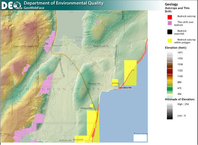
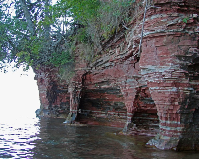
Outcroppings of the Jacobsville occur west of Chassell and farther south along the west side of Pike River, and along the west side of the Sturgeon River Valley pink areas on the map). The most dramatic exposure of the Jacobsville occur in cliffs along the shore of Keweenaw Bay, east of Klingville and Arnheim (red areas on map).
Because of the uranium that occurs in the Jacobsville, houses in the Township should be checked for radon levels in their basements, to insure safe health conditions.
The are no oil and gas wells, mineral leases or gravel quarries listed by the state in the Township.
Glacial landscape and surficial cover.
The landscape shape of the Township is distinctive, as shown by the topographic map. There are gentle hills which are elongated in a N-S direction, probably reflecting glacial erosion patterns which occurred during the most recent glacial period just over 10,000 years ago. A broad alluvial valley which is occupied by the Sturgeon River bisects the township from Arnheim to the Sturgeon Delta and continues North, where it is filled by Portage Lake. This alluvial valley is mostly poorly drained and occupied by wetlands. It was filled by outwash sediments derived from glacial till and moraine when the glaciers retreated. The entire shape of the topography resembles much of Northern Quebec, where smooth gentle hills alternate with flat filled valleys, reflecting the subglacial surface topography which was eroded in the direction of ice flow, and then the low spots were filled with the outwash materials and evolved into lakes and flat river valleys. Agricultural use of the land in the Township is mostly outside of the alluvial valley, which is filled with fine glacial and fluvial sediments and remains saturated with water. The hills surrounding are partly near surface Jacobsville and partly glacial materials covering the Sandstone. The Pike River Valley parallels the Sturgeon but is much narrower.
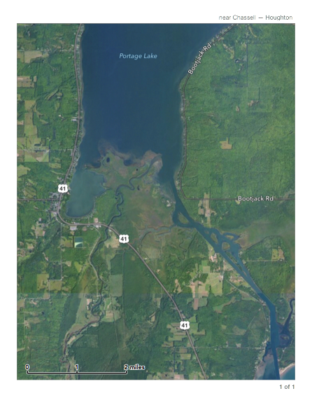
Outstanding Geological Feature: Birdfoot Delta of the Sturgeon River
The Sturgeon River Delta (right) is a classic “birdfoot” delta, like the Mississippi River and many other examples around the world. Birdfoot Deltas form when an active river with currents carrying sediment arrives at its mouth and there is relatively calm water. In this case the calm water is Portage Lake and the delta is built from the accumulation of dropping sedimentary particles. This site could be a focus for educational geological interpretation, along with several other spots in the Township. The access to this feature, both on the surface and by boat offers educational/tourist opportunities for ecoconscious people, and an interpretive plan could be in the Township’s interest.
Alluvial Valley
Jim Belote
Keweenaw Bay Shoreline