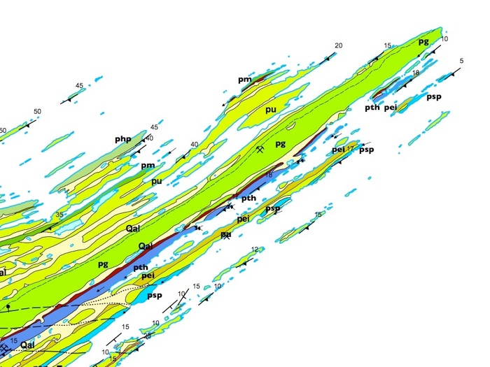
As we round the tip of Isle Royale to Blake Point, we are moving up in the stratigraphic succession. We will first cross the Hill Point flow (php) at Hill Point, then the Minong flow (pm) near Locke Point, and finally the Greenstone flow (pg) at the Palisades. The Greenstone flow is perhaps the earth's largest lava flow.
Hill Pt
Locke Pt
Blake Pt
The following are comments by Longo (1984):
Similarities in the stratigraphic sequence of Isle Royale and the Keweenaw Peninsula of Michigan were recognized by numerous workers prior to 1851. The first thorough study of both areas, conducted by Lane (1893, 1911), resulted in the correlations of specific rock units. One unit in particular, due to its persistence as a prominent ridge on both Isle Royale and the Keweenaw Peninsula, became Lane's most convincing evidence for a correlation across this section of the Lake Superior syncline.
Lane (1893) states, "The backbone ridge thus agrees in every way with the great corresponding ridge on the Keweenaw Point. " Outcrop and drill core data by Lane (1893) reveal this unit as a single immense, differentiated lava flow. Lane (1893) refers to the flow as "the Greenstone, the 'backbone' and biggest ophite of all, with the bed at its base we correlate as the Allouez Conglomerate. " The Greenstone's great thickness and differentiated nature led some workers to consider it as an intrusive sill (Seaman and Seaman 1944; Van Hise and Leith 1911). However, convincing data have proven this unit to be a lava flow (Lane 1893,1911; Butler and Burbank 1929; Broderick 1935, 1946; Cornwall 1951), and henceforth known as the Greenstone flow. Huber (1973a) confirms the similarities of the Greenstone flow on Isle Royale and the Keweenaw Peninsula, and he supported the correlation.
--Longo 1984
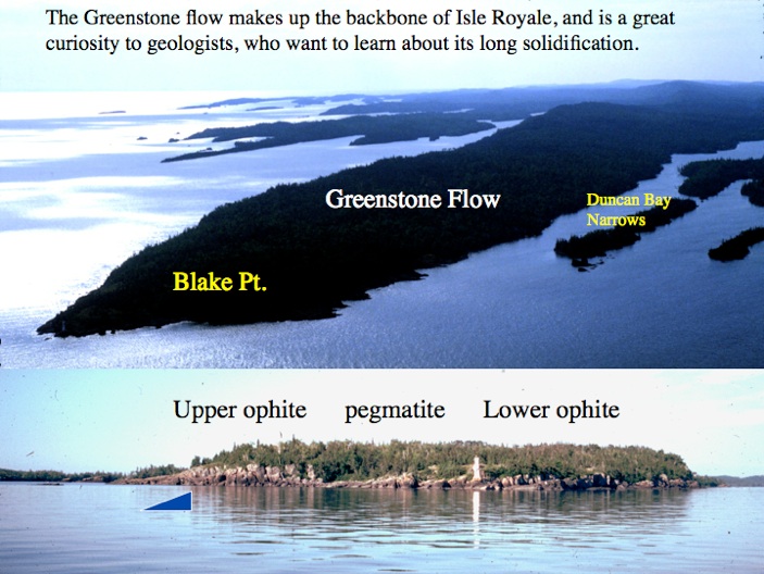
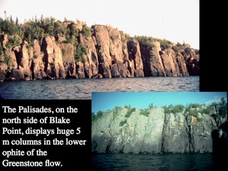
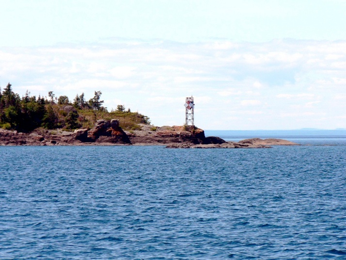
The shoreline around Blake Point offers the best view of the Greenstone flow, better than any other sites at Isle Royale or the Keweenaw Peninsula. On the way to the campground in Merrit Lane, the starting point of our Blake Point walk, we will pass the NW side of Edwards Island, which has good exposures of entablature columnar joints in the Edwards Island flow (pei). The boat will let us off at the Merrit Lane Campground for our walk to Blake Point. We will follow the shoreline from Merrit Lane around the point, remaining close to the wave-washed rocks, yet trying to keep our feet dry. Most of the walk is on the upper ophite unit of the Greenstone flow. (The entablature part of the Greenstone and its flow top is underneath Merrit Lane, and we will see parts of this from the boat later). The upper ophite exhibits a rude columnar structure all along the walk, with the columns perpendicular to the bedding. The size of the oikocrysts increases from top to bottom. After rounding the comer, we will cut through the bushes to descend a cliff that marks the lower anti-dip face of the upper ophite. At the base of this cliff, we will see wave-washed exposures of the pegmatoid, here about 23 m (75 ft.) thick. The contact here appears to be quite sharp, although Huber (1973a) says it is frequently gradational. The pegmatoid underlies the low shoreline and also the area under the light tower. A section of the Greenstone flow is exposed on Passage Island, a 2 km (1.2 mi) long island that can be seen about 4 km (2.5 mi) offshore from Blake Point. Around the corner from the tower and vertically down about 4 m (13 ft.) is the contact with the lower ophite (which is too difficult for us to reach safely). Longo (1984) describes the contact as a gradation over about 1 m of thickness. From here, we will return by the same route to Merrit Lane. Weather permitting, we will travel around the point in the boat to examine the lower ophite cliffs along the Palisades. The columns exposed on the anti-dip slope are up to several meters across. The base of the Greenstone flow is not exposed here.
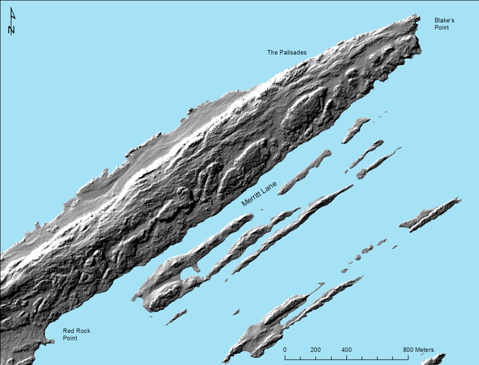
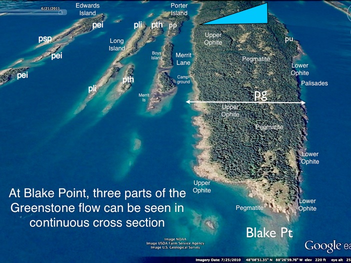
LIDAR survey of all of Isle Royale, with a nominal resolution of about 2 m is newly available for study. The image above came from Seth De Pasqual, at Isle Royale National Park. Most of the land imaged here is the Greenstone Flow and this image is remarkable in showing indications of layering, and also the different character of layers. On the south side of the main land body, facing Merrit Lane, is the eroded fragments of the Upper Ophite layer, with its columnar jointing and dipslope aspect. On the North side there is a steep slope (the Palisades) where the Lower Ophite is exposed on an anti dip slope. In between these two layers lies the pegmatite of the Greenstone, which is 75 ft thick and which appears to be eroding in a somewhat irregular, wavy pattern. It is remarkable that the lidar may show information about these three layers. This information is valuable because we do not have very good exposures most of the time. With field examination, the LIDAR may reveal information about the variable textures in the pegmatite and its origin.