Explosive volcanic eruptions (VEI=4) produce plumes that inject fine pyroclasts called ash (<2mm in diameter) into the stratosphere approximately every 2 years [Textor et al., 2003], with larger events every 5.5 years [Grainger and Highwood, 2003]. Volcanic clouds resulting from these eruptions contain significant proportions of fine ash particles 25 μm diameter [Rose et al., 1980], with atmospheric residence times of hours to days. Fine volcanic ash presents hazards to: (1) aviation [e.g., Casadevall, 1994]; (2) human and animal health [e.g., Baxter et al., 1999]; and (3) infrastructure [e.g., Spence et al., 2005]. Volcanic ash transport and dispersion models (VATDMs) are used to model cloud trajectory and are employed operationally by Volcanic Ash Advisory Centres (VAACs) around the globe to mitigate hazards from fine volcanic ash in the atmosphere following an explosive eruption. The Montreal VAAC is based at the CMC, Montreal, and integrates volcanological, meteorological and aeronautical information to provide warnings to aircraft in the event that a volcanic cloud enters Canadian airspace. Eruptions that may impact this region generally orig- inate from volcanoes in the Pacific �Ring of Fire� and the Mid-Atlantic Ridge.
Why is Cloud Trajectory Analysis Useful?
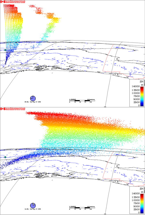
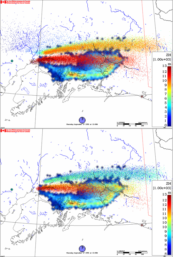
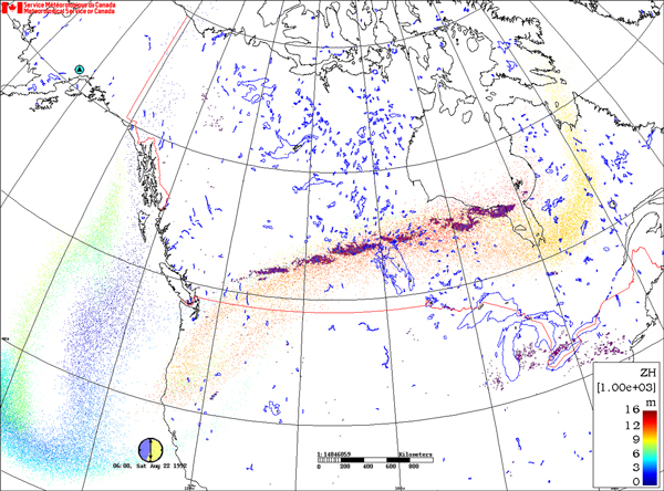
Satellite remote sensing is a powerful method for making rapid observations over a wide area of the Earth. For this reason, it is especially suited to observing the dispersal of volcanic clouds over long distances. Using the �split window techique� (e.g. Prata, 1989) under certain conditions, volcanic clouds can be discriminated through an associated negative brightness temperature difference (BTD). Determination of cloud top temperature can be used to approximate cloud height. However, information on cloud thickness (important for modeling dispersion) cannot be determined using satellite-based remote sensing. Lagrangian VATDMs can be employed to estimate cloud parameters such as thickness and height as a function of time. A simulation is carried out under specified boundary conditions that reflects observations of a given eruption (e.g. maximum cloud height, emission duration, grain-size, mass erupted). Cloud height and thickness can be constrained through comparison of model predicted particle position with satellite-observed cloud position after dispersion from a specified point source (volcano). Included in the boundary conditions is a description of the emission source with initial vertical particle number/mass distribution, which subsequently evolves according to the atmospheric dynamics.
1992 Eruptions of Mount Spurr
Crater Peak and Mount Spurr are located approx. 125 km west of Anchorage, Alaska. Crater Peak is a basaltic-andesite stratocone which has been active for at least the last 5,000 years. It is the surface expression of a satellite vent that formed 10,000-20,000 B.P. and truncates an ancestral stratovolcano. Mount Spurr is an ice-covered, andesite lava dome complex adjacent to Crater Peak, and has not erupted in historic times. Crater Peak erupted on 27 June, 18 August, and 16-17 September 1992. Many sources of observational data exist for the volcanic cloud and associated fallout deposit from this eruption including radar [Rose et al., 1995], satellite remote sensing [Bluth et al., 1995; Rose et al., 2001; Schneider et al., 1995] and field-focused studies [McGimsey et al., 2002; Neal et al., 1995]. For this reason, the 1992 Spurr eruptions provide an excellent source of data to test atmospheric dispersion and fallout models, essential for the mitigation of volcanic clouds.
Baxter, P.J., J.C. Baubron, and R. Coutinho, Health hazards and disaster potential of ground gas emissions at Furnas volcano, Sao Miguel, Azores, J. Volcanol. Geotherm. Res., 92 (1-2), 95-106, 1999.
Bluth, G.J.S., C.J. Scott, I.E. Sprod, C.C. Schnetzler, A.J. Krueger, L.S. Walter, and T.E.C. Keith, Explosive emissions of sulfur dioxide from the 1992 Crater Peak eruptions, Mount Spurr Volcano, Alaska, in T.E.C. Keith (ed), The 1992 eruptions of Crater Peak Vent, Mount Spurr volcano, Alaska, pp. 37-45, U. S. Geological Survey, Reston, VA, 1995.
Casadevall, T.J., Volcanic ash and aviation safety: proceedings of the first international symposium, Seattle, Washington, July 1991, US Geological Survey Bulletin, 2047, 450, 1994. E
ichelberger, J.C., T.E.C. Keith, T.P. Miller, and C.J. Nye, The 1992 eruptions of Crater Peak vent, Mount Spurr Volcano, Alaska; chronology and summary, in T.E.C. Keith (ed), The 1992 eruptions of Crater Peak Vent, Mount Spurr volcano, Alaska, pp. 1-18, U. S. Geological Survey, Reston, VA, 1995.
Grainger, R.G., E.J. Highwood, C. Oppenheimer, D.M. Pyle, and J. Barclay, Changes in stratospheric composition, chemistry, radiation and climate caused by volcanic eruptions, in C Oppenheimer, D M Pyle and J Barclay (eds), Volcanic Degassing, pp. 329-347, Geological Society of London, London, United Kingdom, 2003. Keith, T.E.C. (ed), The 1992 eruptions of Crater Peak Vent, Mount Spurr volcano, Alaska, U.S. Geological Survey Bulletin 2139, 1995.
McGimsey, R.G., C.A. Neal, and C.M. Riley, Areal distribution, thickness, mass, volume, and grain size of tephra-fall deposits from the eruptions of Crater Peak vent, Mt. Spurr Volcano, Alaska, U.S. Geological Survey Open-File Report 01370, 2002.
Neal, C.A., R.G. McGimsey, C.A. Gardner, M.L. Harbin, C.J. Nye, and T.E.C. Keith, Tephra-fall deposits from the 1992 eruptions of Crater Peak, Mount Spurr Volcano, Alaska; a preliminary report on distribution, stratigraphy, and composition, in T.E.C. Keith (ed), The 1992 eruptions of Crater Peak Vent, Mount Spurr volcano, Alaska, pp. 65-79, U. S. Geological Survey, Reston, VA, 1995.
Prata, A.J., Observations of volcanic ash clouds in the 10-12 μm window using AVHRR/2 data, Int J Remote Sens, 10, 751-761, 1989.
Rose, W.I., G.J.S. Bluth, D.J. Schneider, G.G.J. Ernst, C.M. Riley, L.J. Henderson, and R.G. McGimsey, Observations of volcanic clouds in their first few days of atmospheric residence; the 1992 eruptions of Crater Peak, Mount Spurr Volcano, Alaska, Journal of Geology, 109 (6), 677-694, 2001.
Rose, W.I., Jr., R.L. Chuan, R.D. Cadle, and D.C. Woods, Small particles in volcanic eruption clouds, Am. J. Sci., 280 (8), 671-96, 1980.
Rose, W.I., A.B. Kostinski, L. Kelley, and T.E.C. Keith, Real-time C-band radar observations of 1992 eruption clouds from Crater Peak, Mount Spurr Volcano, Alaska, in T.E.C. Keith (ed), The 1992 eruptions of Crater Peak Vent, Mount Spurr volcano, Alaska, pp. 19-26, U. S. Geological Survey, Reston, VA, 1995.
Schneider, D.J., W.I. Rose, L. Kelley, and T.E.C. Keith, Tracking of 1992 eruption clouds from Crater Peak vent of Mount Spurr Volcano, Alaska, using AVHRR, in T.E.C. Keith (ed), The 1992 eruptions of Crater Peak Vent, Mount Spurr volcano, Alaska, pp. 27-36, U. S. Geological Survey, Reston, VA, 1995.
Spence, R.J.S., P.J. Baxter, and G. Zuccaro, Building vulnerability and human casualty estimation for a pyroclastic flow: A model and its application to Vesuvius, J. Volcanol. Geotherm. Res., 133 (1-4), 321-343, 2004.
Textor, C., H.-F. Graf, M. Herzog, and J.M. Oberhuber, Injection of gases into the stratosphere by explosive volcanic eruptions, J Geophys Res, 108 (D19), 5-1, 2003.
Many thanks to Rene Servranckx and others at CMC for making this possible. Please contact Adam Durant for more information: ajdurant @ mtu.edu